卞子浩 , 马小雪
, 马小雪
Bian Zihao, Ma Xiaoxue
中图分类号: P90
文献标识码: A
文章编号: 1000-0690(2017)02-0252-07
通讯作者:
收稿日期: 2016-03-4
修回日期: 2016-05-18
网络出版日期: 2017-02-25
版权声明: 2017 《地理科学》编辑部 本文是开放获取期刊文献,在以下情况下可以自由使用:学术研究、学术交流、科研教学等,但不允许用于商业目的.
基金资助:
作者简介:
作者简介:卞子浩(1994-),男,安徽,硕士研究生,研究方向:自然地理与生态水文学。E-mail: bianzihao@126.com
展开
摘要
基于快速城镇化背景下秦淮河流域土地利用历史状况,选择CLUE-S模型对其2020年土地利用情况进行模拟预测。分别使用线性回归、Markov模型、灰色GM(1,1)模型预测CLUE-S模型非空间模块的土地利用需求量,再嵌入CLUE-S中得到3种预测结果,对预测结果进行比较。另外设定“自然发展”情景与考虑规划政策影响的“优化格局”情景,模拟2020年不同情景下秦淮河流域土地利用格局情况,并进行景观格局分析。结果表明:线性回归模型、Markov模型、灰色GM(1,1)模型的Kappa指数分别为0.866、0.849、0.867,3种方法均满足模型精度要求;自然发展情景中2020年水域、水田、林地、城镇用地、旱地面积相对于2010年分别变化21.5%、-15.3%、-9.0%、51.5%、-28.9%,而优化格局情景下水域、水田、林地、城镇用地、旱地面积分别变化3.1%、-1.6%、10.8%、6.3%、-10.6%,相比于自然发展情景,优化情景土地利用状况更符合保护基本农田、增加生态用地连通性、提高雨水下渗能力以及缓解城市热岛效应的要求,为后期土地利用规划提供了依据。
关键词:
Abstract
Under the background of rapid urbanization in the Qinhuai River Watershed, models of land use change are primary tools for analyzing the causes and consequences of land use changes. We choose CLUE-S model to simulate the land use situation of it in 2020. We use linear regression model, Markov model and the gray GM (1, 1) model respectively to predict the demand for land use which is needed by the non-spatial module of CLUE-S model, then we compared the three forecast results.In order to further verify the influence of policy on land use change, two prediction scenarios were established, one is "natural development" scenario where land use will change according to historical trend and the other is "optimization" scenario which considered the effects of planning policy. We simulated the Qinhuai River Watershed land use pattern in 2020 under different scenarios, and analyze the landscape pattern of it. The results shows that the Kappa index of Linear regression model, Markov model, the gray GM (1, 1) model are 0.866, 0.849, 0.867 respectively, so three methods all satisfy the requirements of model accuracy; In “natural development” scenario, the water area, paddy field, forest land, urban land and the dry farm change, compared to 2010, by 21.5%, 15.3%, 9.0%, 9.0%, 9.0%, respectively, while in “optimization” scenario water area, paddy field, forest land, urban land and the dry farm change by 3.1%, 1.6%, 10.8%, 6.3%, 10.8%, respectively; Under the “optimization” scenario, the land use condition can meet the requirement of protection of basic farmland and ecological land, increasing infiltration capacity of rainwater, and alleviating the urban heat island effect. This work could be the reference for the choice of the method of non-spatial module and provide scientific support for land use planning and managements of the watershed.
Keywords:
陆地表层是未来地球计划的研究主体,土地利用变化是陆地表层中人类活动对地球环境变化影响的最直接体现[1,2]。近20 a来,国际全球环境变化人类行为计划(IHGP)和国际地圈生物圈计划(IGBP)的共同执行计划LUCC(Land Use and Land Cover Change)的实施,极大促进了土地利用变化科学的发展[3]。土地利用变化模型可以帮助人们更好地理解社会、经济、物理变量对土地利用变化影响的机制[4],因而已得到广泛地应用,尤其在未来土地利用情景模拟和预测中越来越发挥重要作用[5]。土地利用模拟常用元胞自动机方法,即根据周边土地利用类型和人为定义的驱动力确定元胞内土地利用类型,但是其邻域转换规则依赖于用户的经验知识,驱动力与土地利用的关系也通常是经验性的。此外还有部分模型常常只能模拟一种土地利用类型转变,因而它们都没有解释好不同土地利用类型之间的竞争性。CLUE-S模型属于一种动态的、较小尺度上的土地利用变化空间分布模拟模型,其根据土地利用与驱动因子之间的关系来模拟土地利用变化,和其它模型相比,其可以在模拟过程中考虑不同土地利用类型之间竞争性。但目前CLUE-S模型只支持土地利用变化的空间分配,而非空间的土地利用变化需要事先运用其它方法进行计算或估计,再作为参数输入模型。目前已有诸多方法被应用于非空间土地需求量计算上,其中包括Markov模型[6]、GM(1,1)模型[7]和时间序列函数方法[8]等预测方法。在目前的研究中,对于非空间部分模型的选择,通常受到研究者自身认识和数据获取的局限,不同嵌入模型之间效果的比较和总结研究较少[9]。本文利用CLUE-S模型模拟秦淮河流域2020年土地利用变化情况,并分别使用线性回归、Markov模型、灰色GM(1,1)模型模拟计算土地需求量嵌套入CLUE-S模型非空间模块中,并对模拟结果进行比较,为后期该模型使用过程中非空间方法的选择提供依据。同时,CLUE-S模型通过输入不同的土地需求参数以及土地转换参数,能够较好模拟政策控制下土地利用变化情况[10],因此被较多的应用于区域土地利用优化[8]。通过模拟不同情景下秦淮河流域土地利用情况,反映政策导向下未来土地利用优化方式,为流域土地利用规划提供参考。
秦淮河流域位于江苏省西南部,流域面积2 635.75 km2,流域范围介于31°55′N~32°02′N、118°39′E~118°53′E之间。流域涉及到南京和镇江的句容两市,其中南京占全流域的64.38%,镇江的句容市占35.62%。秦淮河流域的地形为完整的构造盆地,呈蒲扇形,四面环山,为茅山山脉和宁镇山脉所包围,中间低洼平原地区,地势平坦,最高海拔为450 m。流域气候属于亚热带湿润季风气候,流域年平均气温15℃,多年平均降水量1 034~1 276 mm。
土地利用图来自地球系统科学数据共享网项目“江苏省1:10万土地利用数据集”,包括2000年、2005年、2010年3期土地利用数据;土地利用类型分为水域、林地、水田、城镇用地、旱地5种土地利用类型。DEM数据来自于NASAwist网站ASTERG-Dem数据集;交通路网数据通过在1:193万江苏省全图基础上矢量化得到;水系数据来自于江苏省水利厅。
根据表1,2000~2010年,秦淮河流域经历了快速城镇化过程,城镇用地增长了64%,而水田、林地、旱地均有部分减少[11]。此外,2005~2010年城镇化速度大于2000~2005年的城镇化速度,表明秦淮河流域城镇化速度在近期有增长态势。这些过程与秦淮河流域内快速城镇化过程相关[11]。
表1 秦淮河流域土地利用变化(hm2)
Table 1 Land use change of the Qinhuai River Watershed (hm2)
| 年份 | 水域 | 水田 | 林地 | 城镇用地 | 旱地 |
|---|---|---|---|---|---|
| 2000 | 12056.25 | 109006.30 | 31900.00 | 37600.00 | 73012.50 |
| 2005 | 13425.00 | 105712.50 | 31650.00 | 44687.50 | 68100.00 |
| 2010 | 13387.50 | 100631.30 | 31256.25 | 61662.50 | 56637.50 |
CLUE-S模型借用Logistic回归分析法对不同土地利用类型与各种驱动因素之间的关系进行定量分析。
式中,
CLUE-S模型通过对土地利用变化进行空间分配迭代以实现模拟,迭代方程为:
式中,
CLUE-S模型的非空间模块为研究区土地需求量预测值,其需要通过外界直接输入,因此在非空间模块需要嵌入其它模型或方法进行计算。基于时间数据序列的预测方法是土地利用预测的主流方法之一,其主要根据研究对象的时间数据序列分布特征,寻找系统规律,并预测其未来发展趋势。对于外部资料相对较少的秦淮河流域,时间序列法是预测土地需求量较为合适的方法。目前土地利用时间序列方法的主流方法包括回归方程预测法、灰色GM(1,1)模型预测法和马尔可夫链预测法[13]。回归方程预测主要采用线性回归的方法进行预测分析,灰色GM(1,1)模型预测法和马尔可夫链预测法介绍如下:
1)灰色GM(1,1)模型。该模型令
式中:
2) 马尔可夫模型。
本文分别使用这3种模型模拟计算土地需求量并嵌套入CLUE-S模型之中,并进行计算结果比较。
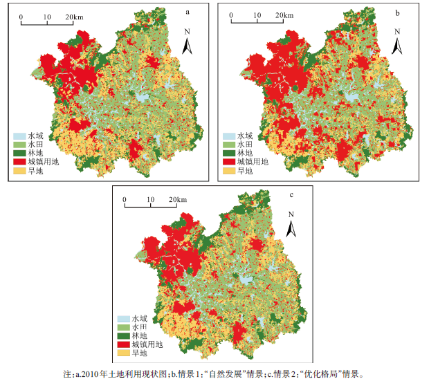
土地利用变化是以人类活动为主导的地表系统变化,其发展受政策、规划等人为影响很大。本研究情景研究中模拟2020年秦淮河流域景观格局,分别设置2种不同情景:情景1“自然发展”情景和情景2“优化格局”情景。
情景1是按照2000~2010年的土地利用转移速率发展模拟得到2020年土地利用格局,在需求量模拟方法上选择Markov模型进行模拟。
情景2是根据不同政策要求以及经济发展与环境保护需求进行综合设置。首先根据《南京市土地利用总体规划(2006~2020年)》、《镇江市土地利用总体规划(2006~2020年)》中关于基本农田保护、严格控制建设用地、生态绿地建设等要求,将耕地面积(水田和旱地)控制在流域面积56.8%,城镇用地控制在24.9%,林地面积提高至13%。其次,根据最严格水资源保护条例,保证水域面积最终稳定在5.2%。最后,根据生态廊道建设,海绵城市建设等理念,通过调整不同用地转换规则以及弹性参数进行土地利用格局的优化布局。
以2005年秦淮河流域土地利用数据为基础,设置到道路距离、到行政中心距离、人口、GDP、到河流距离、坡度、高程等社会经济因子和自然因子作为土地利用变化的驱动力。通过公式(1)计算得到Logistic回归参数,使用ROC值检验Logistic方程回归结果,水域、水田、林地、城镇用地、旱地的ROC值分别为:0.694、0.705、0.936、0.790、0.629。所选取的驱动力因子满足模型的回归要求,可以应用于秦淮河流域土地利用空间布局模拟。
分别使用线性回归、Markov模型、灰色GM(1,1)模型根据秦淮河流域2000~2010土地利用变化历史趋势计算得到2020年各用地类型土地需求值,结果见表2。对比3种方法模拟的需求结果可知,通过灰色GM(1,1)模拟得到的城镇用地、旱地、水田等需求量大于线性回归和Markov模型;Markov模型模拟的结果中旱地、水田需求量相对较小,而水域需求量较大;线性回归方法模拟得到的结果中城镇用地、水域等需求量相对较小,林地需求量接近灰色GM(1,1)模拟结果,而旱地需求与Markov模型模拟的结果一致。从土地利用变化幅度来看,相比于2005年,Markov模型的模拟结果土地利用变幅较大,水域、水田、林地、城镇用地、旱地变幅分别为21.1%、-19.4%、-10.1%、109.0%、-40.9%;线性回归模型模拟结果土地面积变幅较小,水域、水田、林地、城镇用地、旱地变幅分别为9.6%、-12.7%、-3.3%、91.8%、-40.9%;灰色GM(1,1)模拟结果变幅大多与线性回归模型接近,但是城镇用地变幅达到133.5%,相对偏高,而旱地变幅则相对偏低。
表2 2020年秦淮河流域土地利用需求量(hm2)
Table 2 Land use demand of the Qinhuai River Watershed in 2020(hm2)
| 模型 | 水域 | 水田 | 林地 | 城镇用地 | 旱地 |
|---|---|---|---|---|---|
| 线性回归 | 14718.75 | 92256.25 | 30612.50 | 85725.00 | 40262.50 |
| Markov | 16262.50 | 85193.75 | 28450.00 | 93406.25 | 40262.50 |
| 灰色GM(1,1) | 14837.57 | 93028.72 | 30631.40 | 104366.10 | 44829.32 |
将Logistic回归结果、主参数文件、转换规则等相关参数输入模型中,同时分别在非空间模块中嵌入3种方法计算得到的土地需求量数据,模拟得到2020年秦淮河流域土地利用模拟图(图1)。以2010年实际土地利用现状图为参照,对3种方法下模拟得到的土地利用结果进行验证,分别计算得到线性回归模型、Markov模型、灰色GM(1,1)模型的Kappa指数为0.866、0.849、0.867,说明分别嵌套这3种模型的CLUE-S模型均可以较好地模拟未来秦淮河流域的土地利用空间格局。
图1 秦淮河流域2005年土地利用现状图与2020年模拟结果
Fig.1 Land use status in 2005 and simulation results in 2020 in Qinhuai River Watershed
图1与2005年土地利用现状图相比,3种方法的模拟结果均在空间格局上发生较大变化,但是图1b、1c、1d之间的空间格局具有较高的一致性。在3种方法的模拟下城镇化过程均主要以原有的城镇用地为基础向外扩散的形式扩张,其中流域西北部地区即南京市市区部分城镇用地面积增长最快,而流域内江宁区、溧水县、句容市原城镇区的扩展也相对较大。所以快速城镇化过程依然是未来秦淮河流域土地利用变化的重要原因。3种方法模拟结果空间结构一致性较大的原因一方面是由于线性回归模型、Markov模型、灰色GM(1,1)模型均是调整CLUE-S模型中非空间模块的变量,而空间模块仍然一致;另一方面,秦淮河流域处于快速城镇化时期,变化幅度最大的城镇用地的年际差异大于各个模型计算得到土地需求的差异,故反映在最终模拟结果上效果不明显。
根据2.3中情景设置方法,以实际2010年景观格局为基础,得到模拟结果如图2(自然情景用Markov模型模拟,优化情景根据规划文件进行设置)。情景1中2020年水域、水田、林地、城镇用地、旱地面积相对于2010年分别变化21.5%、-15.3%、-9.0%、51.5%、-28.9%,情景2中2020年水域、水田、林地、城镇用地、旱地面积变化率分别为3.1%、-1.6%、10.8%、6.3%、-10.6%。从土地利用面积变化看,情景2中城镇用地面积得到控制,林地面积得到提高,耕地面积减少速度得到控制,并综合考虑经济发展用地需求与环境保护用地需求之间的关系。为了具体研究不同情景下CLUE-S模型的模拟结果空间分布差异,从能表征景观的破碎度、多样性和物理连接度等景观意义出发,本研究选取斑块密度(PD)(值越大景观破碎程度越高)、香农多样性指数(SHDI)(值越高表明景观多样性程度较高)、聚集度指数(CONTAG)(值越高表明景观斑块的空间聚集程度越高)、斑块连通性指数(COHES)(值越高土地类型景观在空间上的连通性越好)4类景观格局指数[14],比较2种情景下模拟得到结果的景观格局差异,结果见表3。
图2 2010年土地利用现状与2020年秦淮河流域2种情景下土地利用空间布局模拟
Fig.2 Land use status in 2010 and land use simulations under two kinds of scenarios in 2020
表3 不同情景下秦淮河流域土地利用景观格局指数
Table 3 Land use scape pattern index under different situations
| 情景 | PD | SHDI | CONTAG | COHES |
|---|---|---|---|---|
| 2010年实际 | 1.061 | 1.442 | 23.406 | 97.802 |
| 2020年情景1 | 1.007 | 1.431 | 25.111 | 97.452 |
| 2020年情景2 | 1.068 | 1.451 | 23.659 | 97.771 |
情景2预测得到的土地利用景观格局指数中PD大于情景1,而CONTAG小于情景1。这主要是因为相对于情景1,情景2中城镇用地扩张面积较小,因而景观整体上破碎程度更高,不同土地聚集程度相对更低。情景2中SHDI值和COHES值均高于情景1,反映情景2中土地利用整体多样性较高、空间异质性较强,景观连接性较好。因此情景2中过度的城市扩张得到缓解,生态用地连通性得到了保护,此外通过将城镇用地与其它用地镶嵌布局可以达到缓解热岛效应[15]、建设海绵城市[16]的目的。
通过结合不同土地利用模型,可以综合单一模型的优势来模拟预测复杂的土地利用变化情况[17]。目前不同模型相结合进行土地预测研究较多,而不同模型结合的土地利用模拟结果之间比较偏少。CLUE-S模型提供了一个适用于多模型结合的平台[18],目前与CLUE-S模型想结合进行土地利用研究的模型,除了常用的线性回归模型、Markov模型、灰色GM(1,1)模型,还包括SD模型[17]、GLP模型[19]、GTAP模型[20]等。不同模型对不同研究区的适用性比较对于后期模型方法的选择十分必要,因此后期还需要进一步研究。
本文不同模型结合的计算结果存在差异,但是反映在最终土地利用空间布局上差异不大,一方面说明了3种方法在进行土地利用时间序列预测上均存在有效性,另一方面导致该结果的原因是由于秦淮河流域处于快速城镇化时期,变化幅度最大的城镇用地的年际差异大于各个模型计算结果之间的土地需求的差异,故反映在最终模拟结果上效果不明显。因此在未来土地利用变化预测研究中需要进一步地进行多模型模拟结果的比较研究,充分研究不同模型所适用于的不同模拟环境条件、数据条件等。此外,灰色模型是针对单一地类进行模拟,为保证总用地面积一致需要按比例进行调整,而对于这一调整方法的有效性仍需要进一步证明。
分别使用线性回归模型、Markov模型、灰色GM(1,1)模型3种方法与CLUE-S模型相结合来模拟2020年秦淮河流域土地利用模拟情况。3种方法所得到的模拟结果均满足精度要求,说明这3种基于时间序列的土地利用模拟方法均适用于秦淮河流域。
土地利用预测分别设置自然发展情景与土地优化情景,并通过调整模型参数得到不同情景下秦淮河流域土地利用发展模拟结果。优化情景下土地利用考虑基本农田保护、严格控制建设用地、最严格水资源保护条例等规划政策背景下的土地利用需求,在模拟结果中实现保护耕地,缓解城市扩张以及稳定水域面积的目标。同时,通过调整模型参数优化情景进一步改善土地利用的景观格局,使得生态用地连通性提高,此外通过城镇用地与其它用地镶嵌布局,提高雨水的下渗能力以及能缓解城市热岛效应。本研究将为后期土地利用规划提供了一定参考。
The authors have declared that no competing interests exist.
| [1] |
面向“未来地球”计划的陆地表层格局研究 [J].https://doi.org/10.11820/dlkxjz.2015.01.002 URL [本文引用: 1] 摘要
未来地球计划是目前国际上关于全球环境变化前沿研究的综合科学计划,集国际科学理事会(ICSU)所领导的四大科学计划为一体,旨在将自然科学与社会科学结合在一起,并加强决策支持和研究交流,寻求地球系统可持续途径,全球环境变化研究与人类学、社会学合作构建综合集成平台,推进科学研究为社会经济可持续发展服务。本文剖析陆地表层格局特点,分析陆地表层格局的国内外关注焦点及其研究理念的转变与应用领域的拓展。分析表明陆地表层是未来地球计划关注的重点之一,陆地表层要素与过程相互作用并在人类活动驱动下形成的格局,可作为未来地球计划进一步研究的区域基础框架。未来,陆地表层格局研究应力求方法论的突破,为自然地理学综合研究的发展提供支撑。
Tang Qiuhong et al. Land surface pattern study under the framework of Future Earth. https://doi.org/10.11820/dlkxjz.2015.01.002 URL [本文引用: 1] 摘要
未来地球计划是目前国际上关于全球环境变化前沿研究的综合科学计划,集国际科学理事会(ICSU)所领导的四大科学计划为一体,旨在将自然科学与社会科学结合在一起,并加强决策支持和研究交流,寻求地球系统可持续途径,全球环境变化研究与人类学、社会学合作构建综合集成平台,推进科学研究为社会经济可持续发展服务。本文剖析陆地表层格局特点,分析陆地表层格局的国内外关注焦点及其研究理念的转变与应用领域的拓展。分析表明陆地表层是未来地球计划关注的重点之一,陆地表层要素与过程相互作用并在人类活动驱动下形成的格局,可作为未来地球计划进一步研究的区域基础框架。未来,陆地表层格局研究应力求方法论的突破,为自然地理学综合研究的发展提供支撑。
|
| [2] |
Future Earth. Future Earth initial design report [R/OL].2013. . 2015-10-05. |
| [3] |
土地利用/土地覆被变化(LUCC)模型研究进展 [J].https://doi.org/10.3321/j.issn:0375-5444.2009.04.008 URL [本文引用: 1] 摘要
土地利用/土地覆被变化(LUCC)是全球环境变化的重要原因,LUCC模型研究始终是土地变化科学研究的重点。论文系统总结了近10年来国内外LUCC模型在理论、方法、实践应用等方面取得的新进展,指出了亟待解决的问题,并对今后的发展方向进行了展望。研究发现,①LUCC模型的功能和作用呈现多样化趋势,是了解、认识和解释土地利用系统的动态变化特征、过程和效应的有效工具,可以服务于土地利用管理和政策的制订。②模型的核心内容是研究LUCC时空变化格局,模型发展正经历从单一的非空间模型向非空间模型和空间模型融合的演进过程,但多数模型只重视空间变化机制研究,而对时间机制考虑不足。③反馈机制是LUCC系统的一个重要特征,现有模型在反馈机制方面的研究尚十分薄弱,研究不同时空尺度的反馈机制必将是未来LUCC模型的新焦点。④LUCC研究本质上是“人类-环境”关系研究,以往模型多为局部均衡分析模型,未来LUCC模型发展趋向应从系统观和整体观角度来综合考虑“人类-环境”相互作用机制,这也是LUCC模型的最高更次的科学难点问题。⑤多尺度、多层次的综合研究是LUCC模型的必然要求,模型空间尺度已经从早期的单一空间尺度转变到现今的多空间尺度,但尺度推移仍是模型研究中值得深入探讨的问题。⑥尽管LUCC模型验证方法趋于多元化,但目前还没有一个模型验证的统一标准和规范,参考数据的不足也大大限制了模型验证效果,如何对LUCC模型的可靠性和科学性进行合理验证始终是LUCC模型所面临的关键挑战之一。
Recent progresses of land use and land cover change(LUCC) models. https://doi.org/10.3321/j.issn:0375-5444.2009.04.008 URL [本文引用: 1] 摘要
土地利用/土地覆被变化(LUCC)是全球环境变化的重要原因,LUCC模型研究始终是土地变化科学研究的重点。论文系统总结了近10年来国内外LUCC模型在理论、方法、实践应用等方面取得的新进展,指出了亟待解决的问题,并对今后的发展方向进行了展望。研究发现,①LUCC模型的功能和作用呈现多样化趋势,是了解、认识和解释土地利用系统的动态变化特征、过程和效应的有效工具,可以服务于土地利用管理和政策的制订。②模型的核心内容是研究LUCC时空变化格局,模型发展正经历从单一的非空间模型向非空间模型和空间模型融合的演进过程,但多数模型只重视空间变化机制研究,而对时间机制考虑不足。③反馈机制是LUCC系统的一个重要特征,现有模型在反馈机制方面的研究尚十分薄弱,研究不同时空尺度的反馈机制必将是未来LUCC模型的新焦点。④LUCC研究本质上是“人类-环境”关系研究,以往模型多为局部均衡分析模型,未来LUCC模型发展趋向应从系统观和整体观角度来综合考虑“人类-环境”相互作用机制,这也是LUCC模型的最高更次的科学难点问题。⑤多尺度、多层次的综合研究是LUCC模型的必然要求,模型空间尺度已经从早期的单一空间尺度转变到现今的多空间尺度,但尺度推移仍是模型研究中值得深入探讨的问题。⑥尽管LUCC模型验证方法趋于多元化,但目前还没有一个模型验证的统一标准和规范,参考数据的不足也大大限制了模型验证效果,如何对LUCC模型的可靠性和科学性进行合理验证始终是LUCC模型所面临的关键挑战之一。
|
| [4] |
Simulating land use change in urban renewal areas: A case study in Hong Kong [J].https://doi.org/10.1016/j.habitatint.2014.10.008 URL [本文引用: 1] 摘要
A considerable amount of research has been conducted on land use change, as it is extremely helpful when it comes to decision-making and policy formulation. Although land use change in urban renewal areas differs from that in new towns, very little research has focused on urban renewal and even less at the local or district level where most decisions need to be made. This study therefore developed a model for simulating land use change in urban renewal districts by combining the conversion of land use and its effects at small regional extent (CLUE-S) model and the Markov chain prediction model. The Yau Tsim Mong district of Kowloon in Hong Kong was the study area for the simulation, and historical land utilization data from 2000 to 2009 was used to validate the proposed model. By applying the validated model, four future land use scenarios were simulated for 2018 (the baseline scenario, the open space scenario, the residential scenario and the balanced scenario). The results not only indicate the effectiveness of the proposed model but also provide alternatives for future urban renewal based on different policy directions taken in the land use planning process.
|
| [5] |
Scenario-based studies of future land use in Europe [J].https://doi.org/10.1016/j.agee.2005.11.023 URL [本文引用: 1] 摘要
Atmospheric aerosols from natural and anthropogenic processes have both primary and secondary origins, and can influence human health, visibility, and climate. One key process affecting atmospheric concentrations of aerosols is the formation of new particles and their subsequent growth to larger particle sizes. A field study was conducted at the Blodgett Forest Research Station in the Sierra Nevada Mountains of California from May through September of 2002 to examine the effect of biogenic volatile organic compounds on aerosol formation and processing. The study included in-situ measurements of concentration and biosphere-atmosphere flux of VOCs, ozone, aerosol size distribution, aerosol physical and optical properties, and meteorological variables. Fine particle growth events were observed on approximately 30 percent of the 107 days with complete size distribution data. Average particle growth rates measured during these events were 3.8 +/- 1.9 nm hr(-1). Correlations between aerosol properties, trace gas concentrations, and meteorological measurements were analyzed to determine conditions conducive to fine particle growth events. Growth events were typically observed on days with a lesser degree of anthropogenic influence, as indicated by lower concentrations of black carbon, carbon monoxide, and total aerosol volume. Days with growth events also had lower temperatures, increased wind speeds, and larger momentum flux. Measurements of ozone concentrations and ozone flux indicate that gas phase oxidation of biogenic volatile organic compounds occur in the canopy, strongly suggesting that a significant portion of the material responsible for the observed particle growth are oxidation products of naturally emitted very reactive organic compounds.
|
| [6] |
基于CLUE-S和Markov复合模型的土地利用情景模拟研究——以江苏省环太湖地区为例 [J].https://doi.org/10.3969/j.issn.1000-0690.2009.04.019 URL [本文引用: 1] 摘要
基于江苏省环太湖地区1990、2000年TM影像和2005年中巴卫星遥感影像,综合集成区域DEM、交通图和居民点分布图等,充分利用CLUE—S模型空间模拟特长和Markov模型数量预测优势,应用CLUE—S和Markov复合模型及GIS分析技术分别对现有土地转移速率发展和根据规划约束对转移概率进行调整的严格保护耕地的土地利用变化情景进行时空模拟,揭示不同情景下的土地利用格局变化。通过模拟得知,江苏省环太湖地区今后确需控制建设用地总量,提高节约集约用地水平,最严格地保护水田等优质耕地。
ZuoTianhui et al. Land use scenarios simulation based on CLUE-S and Markov Composite model——A Case Study of Taihu Lake Rim in Jiangsu Province. https://doi.org/10.3969/j.issn.1000-0690.2009.04.019 URL [本文引用: 1] 摘要
基于江苏省环太湖地区1990、2000年TM影像和2005年中巴卫星遥感影像,综合集成区域DEM、交通图和居民点分布图等,充分利用CLUE—S模型空间模拟特长和Markov模型数量预测优势,应用CLUE—S和Markov复合模型及GIS分析技术分别对现有土地转移速率发展和根据规划约束对转移概率进行调整的严格保护耕地的土地利用变化情景进行时空模拟,揭示不同情景下的土地利用格局变化。通过模拟得知,江苏省环太湖地区今后确需控制建设用地总量,提高节约集约用地水平,最严格地保护水田等优质耕地。
|
| [7] |
基于CLUE-S模型和GIS的土地利用变化模拟研究 [D].Simulation of land use change based on CLUE-S model and GIS: The case of Wuzhong country, Suzhou city. |
| [8] |
基于CLUE-S模型的土地利用空间布局多情景模拟研究——以甘肃省榆中县为例 [J].
利用CLUE-S模型,以甘肃省榆中县为案例区,基于1996年土地利用现状,对2008年土地利用进行模拟,在200 m×200 m模拟尺度下,Kappa指数为0.82.在此基础上,设置耕地保护、建设发展和生态保护3种土地利用空间布局情景,模拟2020年不同情景下榆中县土地利用空间布局.结果表明:耕地保护情景下,耕地稳定性较高,分布集中连片,主要集中在榆中盆地,耕地转出主要集中在北部地区,主要转变为草地和林地;建设发展情景下,建设用地围绕榆中县城关镇扩展,主要由耕地和草地转入,耕地的稳定性较差;生态保护情景下,林地和草地得到较好保护,呈现集中连片特征,地势较高处的耕地转变为林地和草地.生态保护情景下,土地利用空间格局的聚集性最高,连通性最好.CLUE-S模型是模拟榆中县土地利用空间布局的有力工具,模拟结果可为该区土地利用规划修编和未来城市规划布局提供科学依据.
Multi-simulation of Spatial Distribution of Land Use Based on CLUE-S Model: A Case Study of Yuzhong County, Gansu Province.
利用CLUE-S模型,以甘肃省榆中县为案例区,基于1996年土地利用现状,对2008年土地利用进行模拟,在200 m×200 m模拟尺度下,Kappa指数为0.82.在此基础上,设置耕地保护、建设发展和生态保护3种土地利用空间布局情景,模拟2020年不同情景下榆中县土地利用空间布局.结果表明:耕地保护情景下,耕地稳定性较高,分布集中连片,主要集中在榆中盆地,耕地转出主要集中在北部地区,主要转变为草地和林地;建设发展情景下,建设用地围绕榆中县城关镇扩展,主要由耕地和草地转入,耕地的稳定性较差;生态保护情景下,林地和草地得到较好保护,呈现集中连片特征,地势较高处的耕地转变为林地和草地.生态保护情景下,土地利用空间格局的聚集性最高,连通性最好.CLUE-S模型是模拟榆中县土地利用空间布局的有力工具,模拟结果可为该区土地利用规划修编和未来城市规划布局提供科学依据.
|
| [9] |
CLUE-S模型应用进展与改进研究 [J].https://doi.org/10.11820/dlkxjz.2012.01.001 URL [本文引用: 1] 摘要
土地利用变化是景观生态学重要的研究领域,通过模型模拟土地利用变化趋势是该领域的主要研究内容之一。CLUE-S模型可以全面考虑自然和人文因子,通过迭代方法综合空间分析和非空间分析,较好地模拟小尺度范围内土地利用变化情景,具有综合性、开放性、空间性、竞争效率性等特点,已经在国内外多个地区的土地利用变化研究中得到广泛应用,形成了较为成熟的研究方法。本文概括了CLUE-S模型在LUCC、环境效应和政策效应3方面的应用,从驱动因子选择、土地需求计算探讨了CLUE-S模型的改进和修正,总结出CLUE-S模型当前发展方向是提高预测精度和扩展模型应用,并指出与其他模型的耦合、模型的均衡假设和土地利用变化的过程效应是CLUE-S模型的下一步研究方向。
Recent progresses on the application and improvement of the CLUE-S Model. https://doi.org/10.11820/dlkxjz.2012.01.001 URL [本文引用: 1] 摘要
土地利用变化是景观生态学重要的研究领域,通过模型模拟土地利用变化趋势是该领域的主要研究内容之一。CLUE-S模型可以全面考虑自然和人文因子,通过迭代方法综合空间分析和非空间分析,较好地模拟小尺度范围内土地利用变化情景,具有综合性、开放性、空间性、竞争效率性等特点,已经在国内外多个地区的土地利用变化研究中得到广泛应用,形成了较为成熟的研究方法。本文概括了CLUE-S模型在LUCC、环境效应和政策效应3方面的应用,从驱动因子选择、土地需求计算探讨了CLUE-S模型的改进和修正,总结出CLUE-S模型当前发展方向是提高预测精度和扩展模型应用,并指出与其他模型的耦合、模型的均衡假设和土地利用变化的过程效应是CLUE-S模型的下一步研究方向。
|
| [10] |
Modeling the Spatial Dynamics of Regional Land Use: The CLUE-S Model [J].https://doi.org/10.1007/s00267-002-2630-x URL PMID: 12148073 [本文引用: 1] 摘要
Land-use change models are important tools for integrated environmental management. Through scenario analysis they can help to identify near-future critical locations in the face of environmental change. A dynamic, spatially explicit, land-use change model is presented for the regional scale: CLUE-S. The model is specifically developed for the analysis of land use in small regions (e.g., a watershed or province) at a fine spatial resolution. The model structure is based on systems theory to allow the integrated analysis of land-use change in relation to socio-economic and biophysical driving factors. The model explicitly addresses the hierarchical organization of land use systems, spatial connectivity between locations and stability. Stability is incorporated by a set of variables that define the relative elasticity of the actual land-use type to conversion. The user can specify these settings based on expert knowledge or survey data. Two applications of the model in the Philippines and Malaysia are used to illustrate the functioning of the model and its validation.
|
| [11] |
秦淮河流域1980-2010年土地利用变化及驱动机制 [J].
[目的]研究近30a来秦淮河流域不同时期土地利用/覆被变化特征及驱动力,为秦淮河流域的生态经济系统可持续发展和流域管理提供科学依据。[方法]利用GIS功能对秦淮河地区1980,1995,2000,2005,2008,2010年土地利用现状图进行叠加转换,建立土地利用变化转移矩阵,在此基础上分析秦淮河地区近30a来的土地利用变化特征,并结合相应的社会统计资料分析土地利用变化的驱动力。[结果]流域内耕地面积逐年减少,建设用地面积逐年增加,林草覆盖面积略有减少;土地利用程度变化存在明显的时间差异性,2005—2008期间变化最大;建设用地的增加主要源于耕地的转入,其次是林地、水域;经济发展、人口增长和人民生活水平的提高是该区土地利用/覆被变化的主要驱动力。[结论]城市化发展要素是推动该区建设用地增加、耕地面积减少这一现象的主要驱动力。
Land use change and its driving mechanism in Qinhuai river watershed during 1980-2010.
[目的]研究近30a来秦淮河流域不同时期土地利用/覆被变化特征及驱动力,为秦淮河流域的生态经济系统可持续发展和流域管理提供科学依据。[方法]利用GIS功能对秦淮河地区1980,1995,2000,2005,2008,2010年土地利用现状图进行叠加转换,建立土地利用变化转移矩阵,在此基础上分析秦淮河地区近30a来的土地利用变化特征,并结合相应的社会统计资料分析土地利用变化的驱动力。[结果]流域内耕地面积逐年减少,建设用地面积逐年增加,林草覆盖面积略有减少;土地利用程度变化存在明显的时间差异性,2005—2008期间变化最大;建设用地的增加主要源于耕地的转入,其次是林地、水域;经济发展、人口增长和人民生活水平的提高是该区土地利用/覆被变化的主要驱动力。[结论]城市化发展要素是推动该区建设用地增加、耕地面积减少这一现象的主要驱动力。
|
| [12] |
Land-cover change model validation by an ROC method for the Ipswich watershed, Massachusetts, USA [J].https://doi.org/10.1016/S0167-8809(01)00187-6 URL [本文引用: 1] 摘要
Scientists need a better and larger set of tools to validate land-use change models, because it is essential to know a model鈥檚 prediction accuracy. This paper describes how to use the relative operating characteristic (ROC) as a quantitative measurement to validate a land-cover change model. Typically, a crucial component of a spatially explicit simulation model of land-cover change is a map of suitability for land-cover change, for example a map of probability of deforestation. The model usually selects locations for new land-cover change at locations that have relatively high suitability. The ROC can compare a map of actual change to maps of modeled suitability for land-cover change. ROC is a summary statistic derived from several two-by-two contingency tables, where each contingency table corresponds to a different simulated scenario of future land-cover change. The categories in each contingency table are actual change and actual non-change versus simulated change and simulated non-change. This paper applies the theoretical concepts to a model of deforestation in the Ipswich watershed, USA.
|
| [13] |
中国区域土地利用需求量预测方法研究进展 [J].https://doi.org/10.3969/j.issn.1000-2324.2009.04.037 URL [本文引用: 1] 摘要
研究目的:对1990年以来,我国土地利用需求量预测方法研究的论文进行了检索与分类统计,以预测方法的发展趋势为主线进行回顾分析.研究方法:文献法与比较分析法.研究结果:自1990年以来,我国土地利用需求量预测方法研究逐步深入,其中,灰色预测、马尔可夫链预测方法应用最多,分别占检索论文总数的24.2%和27.4%,研究论文分布在几十种期刊上,论文作者比较分散;在市、县级区域空间尺度上研究较多.研究结论:我国土地利用需求量预测方法主要应用在耕地需求量预测、建设用地量预测、土地利用结构预测等方面,基于RS和GIS技术的数据获取方法得到应用.
The progress of forecast methods of region land use demand in China. https://doi.org/10.3969/j.issn.1000-2324.2009.04.037 URL [本文引用: 1] 摘要
研究目的:对1990年以来,我国土地利用需求量预测方法研究的论文进行了检索与分类统计,以预测方法的发展趋势为主线进行回顾分析.研究方法:文献法与比较分析法.研究结果:自1990年以来,我国土地利用需求量预测方法研究逐步深入,其中,灰色预测、马尔可夫链预测方法应用最多,分别占检索论文总数的24.2%和27.4%,研究论文分布在几十种期刊上,论文作者比较分散;在市、县级区域空间尺度上研究较多.研究结论:我国土地利用需求量预测方法主要应用在耕地需求量预测、建设用地量预测、土地利用结构预测等方面,基于RS和GIS技术的数据获取方法得到应用.
|
| [14] |
Relationships between land use patterns and water quality in the Taizi River basin, China [J].https://doi.org/10.1016/j.ecolind.2014.02.003 URL [本文引用: 1] 摘要
Using land use types and landscape metrics, as well as statistical and spatial analysis, we determined the relationships between land use patterns and river water quality in the Taizi River basin, China, during dry and rainy seasons in 2009. Correlation and multiple linear regressions indicated that vegetated areas had a positive contribution to river water quality and predicted total nitrogen during the rainy season. Built-up land use strongly influenced nitrogen and phosphorus parameters in river water. Agricultural land use was associated with most physicochemical variables and nitrogen during the rainy season. Landscape metrics during both seasons were significantly associated with river water quality. Shannon's diversity index was the primary predictor for chloride and ammoniacal nitrogen. Mean Euclidean nearest neighbor index defined ammoniacal nitrogen, orthophosphate, and total phosphorus during the dry season. Biological oxygen demand and permanganate index were expressed by Contagion during the rainy season. Factor analysis indicated that the river suffered organic, phosphorus, and nitrogen pollution and a zone dominated by agricultural and built-up land uses in the river basin tended to have worse water quality than other areas. The results provide a useful approach that uses landscape patterns to estimate water quality in rivers for water pollution control and land use management.
|
| [15] |
基于景观格局的城市热岛研究进展 [J].https://doi.org/10.5846/stxb201106280965 URL [本文引用: 1] 摘要
首先对城市热岛效应的研究历史、大气城市热岛(AUHI)和地表城市热岛(SUHI)等概念、以及数据获取方式等方面进行简要地概述;随之着重综述从景观格局角度对城市热岛效应进行的研究。统计描述、传统景观格局指数分析和模型模拟法是目前该方向研究的主要方法,统计和景观格局指数分析的研究方法相似,主要统计地表参数或地表景观格局指数与地表温度的相关关系,在SUHI的研究中用得较多;AUHI和SUHI的数据源和机理不尽相同,其研究方法也不同;AUHI一般使用固定气象站点的数据和精细的局部移动气象站数据,较难和景观格局指数结合;模型模拟法则既可以使用地表温度也可以使用大气温度,其结果具体可靠,但目前模型模拟中涉及的景观格局参数,尤其是二维或多维的格局参数并不多;最后从数据源和景观格局参数的参与两个角度讨论了该方向研究存在的问题并提出今后研究的重点,包括(1)针对研究目标,选取或生产最合适的高质量数据;(2)深入从景观格局角度模拟城市热岛效应的研究,尤其是二维和三维景观格局的模拟,并发展多维度的景观格局指数;(3)中尺度上充分利用多光谱遥和热红外遥感数据,结合小尺度的测量和模拟,建立基于机理的景观模型或格局指数以评价中尺度的城市热岛效应;(4)多领域数据的融合和多学科方法的交叉研究和应用。
Studies on urban heat island from a landscape pattern view: a review. https://doi.org/10.5846/stxb201106280965 URL [本文引用: 1] 摘要
首先对城市热岛效应的研究历史、大气城市热岛(AUHI)和地表城市热岛(SUHI)等概念、以及数据获取方式等方面进行简要地概述;随之着重综述从景观格局角度对城市热岛效应进行的研究。统计描述、传统景观格局指数分析和模型模拟法是目前该方向研究的主要方法,统计和景观格局指数分析的研究方法相似,主要统计地表参数或地表景观格局指数与地表温度的相关关系,在SUHI的研究中用得较多;AUHI和SUHI的数据源和机理不尽相同,其研究方法也不同;AUHI一般使用固定气象站点的数据和精细的局部移动气象站数据,较难和景观格局指数结合;模型模拟法则既可以使用地表温度也可以使用大气温度,其结果具体可靠,但目前模型模拟中涉及的景观格局参数,尤其是二维或多维的格局参数并不多;最后从数据源和景观格局参数的参与两个角度讨论了该方向研究存在的问题并提出今后研究的重点,包括(1)针对研究目标,选取或生产最合适的高质量数据;(2)深入从景观格局角度模拟城市热岛效应的研究,尤其是二维和三维景观格局的模拟,并发展多维度的景观格局指数;(3)中尺度上充分利用多光谱遥和热红外遥感数据,结合小尺度的测量和模拟,建立基于机理的景观模型或格局指数以评价中尺度的城市热岛效应;(4)多领域数据的融合和多学科方法的交叉研究和应用。
|
| [16] |
“海绵城市”理论与实践 [J].https://doi.org/10.11819/cpr20150605a URL [本文引用: 1] 摘要
当今中国正面临着水资源短缺,水质污染,洪涝灾害,水生物栖息地丧失等多种水问题。这些水问题综合症是系统性、综合的问题,亟需一个更为综合全面的解决方案。"海绵城市"理论的提出正是立足这一背景。文章基于生态系统服务、景观安全格局等理论,结合北京市、六盘水市以及哈尔滨群力国家湿地公园等案例,详细阐述了"海绵城市"概念的源起、发展、内涵和构建方法体系,指出"海绵城市"有别于传统的工程依赖性治水思路和"灰色"基础设施,它作为一种生态途径,其构建核心在于建立跨尺度的水生态基础设施,以综合解决中国城乡突出的水问题,并对未来"海绵城市"的研究方向提出了展望。
“Sponge City”: Theory and practice. https://doi.org/10.11819/cpr20150605a URL [本文引用: 1] 摘要
当今中国正面临着水资源短缺,水质污染,洪涝灾害,水生物栖息地丧失等多种水问题。这些水问题综合症是系统性、综合的问题,亟需一个更为综合全面的解决方案。"海绵城市"理论的提出正是立足这一背景。文章基于生态系统服务、景观安全格局等理论,结合北京市、六盘水市以及哈尔滨群力国家湿地公园等案例,详细阐述了"海绵城市"概念的源起、发展、内涵和构建方法体系,指出"海绵城市"有别于传统的工程依赖性治水思路和"灰色"基础设施,它作为一种生态途径,其构建核心在于建立跨尺度的水生态基础设施,以综合解决中国城乡突出的水问题,并对未来"海绵城市"的研究方向提出了展望。
|
| [17] |
Combining system dynamic model and CLUE-S model to improve land use scenario analyses at regional scale: A case study of Sangong watershed in Xinjiang, China [J].https://doi.org/10.1016/j.ecocom.2010.02.001 URL [本文引用: 2] 摘要
Uses of models of land use change are primary tools for analyzing the causes and consequences of land use changes, assessing the impacts of land use change on ecosystems and supporting land use planning and policy. However, no single model is able to capture all of key processes essential to explore land use change at different scales and make a full assessment of driving factors and impacts. Based on the multi-scale characteristics of land use change, combination and integration of currently existed models of land use change could be a feasible solution. Taken Sangong watershed as a case study, this paper describes an integrated methodology in which the conversion of land use and its effect model (CLUE), a spatially explicit land use change model, has been combined with a system dynamic model (SD) to analyze land use dynamics at different scales. A SD model is used to calculate area changes in demand for land types as a whole while a CLUE model is used to transfer these demands to land use patterns. Without the spatial consideration, the SD model ensures an appropriate treatment of macro-economic, demographic and technology developments, and changes in economic policies influencing the demand and supply for land use in a specific region. With CLUE model the land use change has been simulated at a high spatial resolution with the spatial consideration of land use suitability, spatial policies and restrictions to satisfy the balance between land use demand and supply. The application of the combination of SD and CLUE model in Sangong watershed suggests that this methodology have the ability to reflect the complex behaviors of land use system at different scales to some extent and be a useful tool for analysis of complex land use driving factors such as land use policies and assessment of its impacts on land use change. The established SD model was fitted or calibrated with the 1987鈥1998 data and validated with the 1998鈥2004 data; combining SD model with CLUE-S model, future land use scenarios were analyzed during 2004鈥2030. This work could be used for better understanding of the possible impacts of land use change on terrestrial ecosystem and provide scientific support for land use planning and managements of the watershed.
|
| [18] |
Projecting land use transitions at forest fringes in the Philippines at two spatial scales [J].https://doi.org/10.1023/B:LAND.0000018370.57457.58 URL [本文引用: 1] 摘要
Abstract This paper presents two applications of a spatially explicit model of land use change at two spatial scales: a nation-wide application for the Philippines at relatively coarse resolution and an application with high spatial resolution for one island of the Philippines: Sibuyan island, Romblon province. The model is based on integrated analysis of socio-economic and biophysical factors that determine the allocation of land use change in combination with the simulation of the temporal dynamics (path-dependence and reversibility of changes), spatial policies and land requirements. Different scenarios of near-future developments in land use pattern are simulated illustrating the effects of implementing spatial policies. Results from the coarse scale model with national extent mainly serve to identify the overall pattern of land use change and hot zones of deforestation. The detailed application provides more insight in the pattern of land use change and its consequences for ecological processes. The use of the results for environmental assessments is illustrated by calculating spatial indices to assess the impact of land use change on forest fragmentation. It is concluded that spatially explicit modeling of land use change yields important information for environmental management and land use planning. The applications illustrate that the scale of analysis is an important determinant of the model configuration, the interpretation of the results and the potential use by stakeholders. There is no single, optimal, scale for land use change assessments. Each scale enables different types of analysis and assessment: applications at multiple scales therefore give complementary information needed for environmental management.
|
| [19] |
Simulating the optimal land-use pattern in the farming-pastoral transitional zone of Northern China [J].https://doi.org/10.1016/j.compenvurbsys.2008.01.001 URL [本文引用: 1] 摘要
This paper describes land-use pattern optimization simulation in the farming-pastoral zone of Northern China. For simulating land-use pattern optimization, the improved Conversion of Land Use and its Effects (iCLUE) model is used, which takes into account both physical and economic factors. The iCLUE model is composed of three modules: gross demand control, spatial analysis, and spatial allocation. In the gross demand control module, the Grey Linear Programming (GLP) method is used to analyze 11 constraint factors covering eight themes of the study area which are then solved by the simplex method. The simulated model is verified by the comparison between the actuality of 2000 and simulated state of 2000. Verified results of the simulation indicate that the iCLUE model can perform land-use optimizing simulation at the regional level effectively, which provides useful information for improving the ecological environment at the regional level.
|
| [20] |
Downscaling of land use change scenarios to assess the dynamics of European landscapes [J].https://doi.org/10.1016/j.agee.2005.11.024 URL [本文引用: 1] 摘要
Abstract Europe's rural areas are expected to witness massive and rapid changes in land use due to changes in demography, global trade, technology and enlargement of the European Union. Changes in demand for agricultural products and agrarian structure are likely to have a large impact on landscape quality and the value of natural areas. A spatially explicit, dynamic, land use change model has been used to translate European level scenarios into a high resolution assessment of changes in land use for the 25 countries of the European Union. Scenarios differ in worldview, ranging from enhanced global cooperation towards strong regionalisation on one hand and strong to weak government intervention on the other. Global economic and integrated assessment models were used to calculate changes in demand for agricultural area at country level while a spatially explicit land use change model was used to downscale these demands to land use patterns at 1 km2 resolution. The land use model explicitly accounts for the variation in driving factors among countries and the path dependence in land use change trajectories. Results indicate the large impact abandonment of agricultural land and urbanization has on European landscapes and the different scenarios indicate that spatial policies can make an important contribution to preserve landscapes containing high natural and/or historic values. Furthermore, the dynamic simulations indicate that the trajectory of land use change has an important impact on resulting landscape patterns as a result of the path-dependence in land use change processes. The results are intended to support discussions on the future of the rural area and identify hotspots of landscape change that need specific consideration.
|

/
| 〈 |
|
〉 |
