杜会石 , 张爽, 陈智文
吉林师范大学生态环境研究所,吉林 四平 136000
Du Huishi, Zhang Shuang, Chen Zhiwen
中图分类号: P931
文献标识码: A
文章编号: 1000-0690(2017)03-0400-06
通讯作者:
收稿日期: 2016-03-7
修回日期: 2016-06-1
网络出版日期: 2017-03-20
版权声明: 2017 《地理科学》编辑部 本文是开放获取期刊文献,在以下情况下可以自由使用:学术研究、学术交流、科研教学等,但不允许用于商业目的.
基金资助:
作者简介:
作者简介:杜会石(1983-),男,吉林伊通人,博士,副教授,主要从事干旱区地貌研究。E-mail:duhs@163.com
展开
摘要
以图们江下游跨国界地区圈河流域河岸沙丘为研究对象,运用遥感与GIS技术,结合遥感影像、地形图等资料,分析该区1984~2015年河岸沙丘空间分布与格局演变,计算河岸沙丘分维值与稳定性指数。结果表明:该区河岸沙丘主要分布在弯曲型河道东岸,呈WNW-ESE向带状展布,面积15.71 km2。近31 a沙丘面积总体呈减少态势,净减少0.09 km2,其中,较少有人类活动的A区,沙丘面积呈减少趋势,减少幅度为8.21%;而受人类活动影响较大的B区,沙丘面积持续增加,尤其近5 a增幅达32%。河岸沙丘分维值虽总体高于内陆沙漠沙丘,但变化不显著,说明河岸沙丘处于相对稳定的发育演化过程中。该研究为图们江下游跨国界地区生态环境可续持发展提供科学依据。
关键词:
Abstract
This article takes the riparian dune of the Quanhe River Basin as the research object which is in trans-boundary area of Tumen River downstream. Based on remote sensing and GIS technology combined with data of remote sensing images and relief map in this area during 1984 to 2015, the spatial distribution and pattern change of riparian dune were analyzed, fractal dimension value and stability index of riparian dune calculated and the formation mechanism and development mode of riparian dune discussed. The results show that the riparian dune of study area is distributed in right coast of the river mainly. The main aeolian landform type include parabolic dunes, barchan dunes and longitudinal dunes, covering an area of about 15.71 km2 and extending as a strip in WNW-ESE direction. On the whole, the aeolian sand landform area of A region is 7.06 km2, and the landform type is mainly composed of fixed parabolic dune. The area of aeolian sand landform in B is 8.65 km2, which is dominated by barchan chain. In resent 31 years, the area of sand dunes in the study area slightly decreased on the whole with a net decrease of 0.09 km2. Besides, the A region that is far away from human activities continued to decrease with a range of 8.21% by now. There appears a trend of continuous reduction during the period of 1984 to 2010 with a decrease of 0.67 km2 with the main performance being the fixed dunes because the vegetation was fixed with an increasing trend during the period of 2010 to 2015. The riparian dune of study area moves toward ESE-SE on the whole which is consistent with the main regional wind direction. The longitudinal section line of parabolic dune in A region extends as a strip in WNW-ESE direction; riparian dune appears as a forward migration in a way that spreads as the tongue shape at the leading edge, with an annual average moving rate of 1.8 m. The B region which is affected by human activities has a significant continuous increasing trend, and the increasing extent reached up to 32% in resent 5 years. It increased by 31% compared with the same period in A region, which also shows that the intensity of human activities greatly influence the development of sand dunes under the background of the same climatic change. The fractal dimension value of riparian dune is higher than that of desert dunes of inland area on the whole. However, there are no significant changes, which shows that riparian dune was in a relatively steady development and evolution process. The research provides scientific basis for sustainable development of ecological environment in trans-boundary area of Tumen River downstream.
Keywords:
沙丘是风力作用下沙粒堆积而成的丘状或垄状地貌[1],学者已对内陆沙漠沙丘及海岸沙丘开展了大量研究,并取得重要成果[2,3]。河岸沙丘是发育在河谷环境,并叠加于河流地貌之上,受风、水交互侵蚀作用而形成的一种风沙地貌类型[4,5]。多发育在干旱半干旱地区河流两侧,其发育的规模和类型因地而异,并与河谷形态、走向、区域风况密切相关[6]。学者逐步认识到风力-河流交互侵蚀对河岸沙丘发育的重要作用,因而,研究并不局限于地层学、沉积学、年代学[7~9]等工作,最近,Liu等[10]基于全球230个河岸沙丘典型分布区遥感影像,对风力、流水交互作用类型进行了6种划分,并对河岸沙丘发育类型与净输沙方向、区域主风向与河流交角、河谷形态与沙丘格局等方面进行了探讨。总体而言,目前对河岸沙丘发育模式的科学假设为:因河流的洪、枯水期交替变化,加之新构造运动,河道发生摆动,砂质河岸的松散冲积砂,在枯水期受风力作用在河流阶地边缘堆积形成沙丘,并在盛行风作用下进一步发育成沙丘链(带)[5,11]。因各地区气象因素、地质环境、人类干预条件不尽相同,学者对其形成机理和发育模式尚未达成共识,亟需开展相关研究,以加深对其发育演化等地表过程的认识和理解。
地处图们江下游跨国界地区的圈河流域,河岸沙丘发育较为典型,是开展河岸沙丘发育演化研究的理想靶区。目前针对该区研究多集中在沙粒结构与碎屑成分[12]、粒度分布特征[13]等方面。3S技术已成为沙漠科学研究的重要手段[14,15],而该区尚缺少长时间序列遥感监测,以揭示沙丘动态演化规律。因此,本文以图们江下游圈河流域河岸沙丘为研究对象,解译分析1984~2015年Landsat系列TM、OLI影像数据,基于遥感和GIS技术,辅以地形图、区域气象水文资料和社会经济统计数据等,研究该区河岸沙丘空间分布、时空动态、格局指数等,并探讨河岸沙丘发育演化的作用机理,为圈河流域区域可持续发展、生态环境建设提供科学依据。
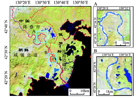
圈河流域位于图们江下游,地处敬信盆地南缘,沉积环境以第四纪更新世冲洪积为主,发育的土壤为草甸暗棕壤。具有显著的温带大陆性气候特点,因距日本海较近,也受到海洋性气候的影响,年平均气温为5.9℃,最高气温32.9℃,最低气温-24.5℃,降水量变化大,季节分布不均。该区是中、朝、俄三国交界鼎足地带[16],圈河的北岸是中国吉林省延边朝鲜族自治州,南岸是朝鲜咸镜北道,东岸是俄罗斯的滨海边疆区(图1),区内湿地资源丰富。圈河两岸地势平坦,平均海拔约16 m,河道坡降较小、水面宽阔,河床以细砂为主,多汊流、江心洲、边滩分布。沿河两侧的沙丘主要分布在圈河流域中段,以及河流末端临近日本海入海口附近,面积约16 km2。河岸沙丘以新月形和抛物线形为主,沙丘主体多以舌状蔓延形式向前迁移,年均移动速率约为0.5~3.6 m。多期遥感影像对比发现,伴随沙丘因沙源供给减少、植被定植而自然固定的同时,部分固定沙丘的前缘也呈现活化现象。河岸沙丘的形态发育,受控于自然因素(区域风况、沙源供给、植被覆盖等)和人文因素,因此,在相似区域地理条件下,考虑沙丘发育演化与人类活动干扰强度的关系,本研究选取2个典型区,分别位于42°34′N~42°37′N,130°27′E~130°32′E(面积64.99 km2)(图1A)与42°26′~42°29′N,130°33′~130°36′E(面积41.16 km2)(图1B),这2个样区也是圈河流域沙丘分布的集中区。其中,A区地势平坦,平均海拔12 m,圈河在此处河床曲折率大于1.5,河岸沙丘分布在河谷的南侧,以固定、半固定、流动抛物线形沙丘为主,该区受人类活动影响较小;而B区位于圈河洋馆坪至防川村段,平均海拔9 m,沙丘分布在NNW-SSE向河谷右岸,以流动新月形沙丘及沙丘链为主,珲春政府在现有沙丘基础上开发了以旅游观光为主要盈利方式的沙丘公园,面积12 km2,2002年被批准为国家级风景区。这2个样区包含了圈河流域河岸沙丘分布的主体,且各样区沙丘发育的类型、形态参数、受人类干扰程度不同,因此,对其开展研究有助于揭示圈河流域河岸沙丘动态演化特征与规律。
1.2.1 数据来源与数据预处理
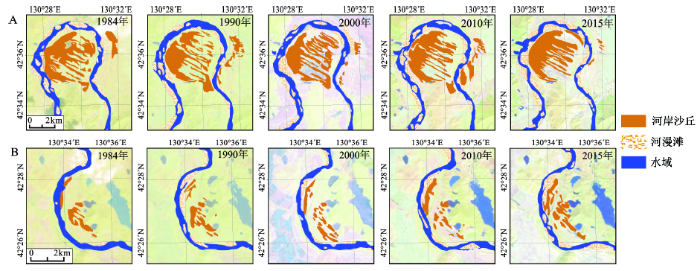
为准确把握沙丘动态变化特征,需选取具有一定时间跨度的遥感数据进行对比分析。本文选用了1984~2015年Landsat TM和OLI影像数据,均为晴空无云影像资料,空间分辨率30 m。同时收集研究区1:10万地形图、植被分布图、地质地貌图,用作影像几何精校正和辅助解译。选取影像数据TM742、OLI753通道进行假彩色合成,以1:10万地形图和野外RTK GPS实地考察验证点为基准,对遥感影像进行几何精校正,误差控制在0.5个像元以内。对同期影像作直方图匹配和拼接处理,再按研究区矢量边界范围对图像进行裁剪。以GIS 平台为技术支持,为提高分类精度,采用人工目视解译的方法,生成研究区河岸沙丘演化图谱(图2)。利用ArcGIS 空间分析(Spatial Analyst)工具,得到近31 a研究区河岸沙丘面积转移数据,用以分析圈河流域河岸沙丘的动态变化情况。
图2 1984~2015年研究区河岸沙丘动态变化
Fig.2 Dynamic change of riparian dune in study area in 1984-2015
1.2.2 景观分形研究
用r为尺度去分析某种景观要素斑块的几何形态[17],则有:
式中,r为景观斑块类别,P(r)为景观斑块周长,A(r)为面积,k为常数。D为景观斑块结构分维值,表示某景观斑块结构的稳定性,其值越大,说明该要素斑块结构越复杂[18]。因此,可用稳定性指数来衡量:
式中,SK为景观斑块结构稳定性,D为景观斑块结构分维值。
从2015年遥感影像可见(图2),河岸沙丘主要分布在河流的右岸。沙丘类型有抛物线形沙丘、新月形沙丘、纵向沙垄等风沙地貌类型,沙丘总体走向WNW-ESE。其中,A区风沙地貌面积7.06 km2,主要分布在圈河九曲的南侧,位于北朝鲜境内,以固定抛物线形沙丘为主,以及由抛物线形沙丘前缘、丘臂活化而形成的新月形沙丘和纵向沙垄,此外,也有小面积风蚀坑分布。从抛物线形沙丘长宽比分析,呈叶形(叶形指数LLWR在1.0~3.0之间)结构,具有较成熟的抛物线沙丘长宽比特点。B区风沙地貌面积8.65 km2,主要分布在圈河右岸,位于中国珲春市敬信镇境内,以新月形沙丘链为主,以及由抛物线形沙丘前缘活化而形成的小面积单体新月形沙丘。
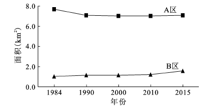
通过对研究区近31 a遥感影像解译数据分析,得到圈河流域河岸沙丘面积变化信息(图3)。研究期内,圈河流域河岸沙丘面积总体呈减少趋势,净减少0.09 km2。但各样区风沙地貌面积变化趋势各异,其中,A区面积总体呈减少趋势,净减少0.63 km2,1984~1990年减少速度较快,年均减少0.10 km2,1990~2010年减速放缓,净减少0.07 km2,而2010~2015年略呈增加趋势,年增长率0.12%,该区人类干扰强度变化不显著,而沙丘面积增加,则主要受区域径流量减少[19]、气候暖干化[20]的影响。B区面积总体呈增加趋势,净增加0.54 km2,其中1984~2010年增速平缓,年增长率0.58%,2010~2015年呈快速增加趋势,年增长率6.39%,实地走访调研发现,自2009年珲春沙丘公园运营以来,年均接待旅游人数约9.2万人次,在与A区具有相同区域气候条件背景下,B区内人类活动的加强对年际尺度沙丘面积快速增加具有重要影响。
沙丘移动性质(移动方向和方式)受控于区域风信状况[1]。该区河岸沙丘移动总体朝ESE-SE向,与区域主风向基本一致。其中,A区抛物线形沙丘纵剖线走向呈WNW-ESE,因该区水分、植被条件较好,加之沙源较少(沙丘多就地起沙或固定沙丘活化),故河岸沙丘以其前缘舌状蔓延形式向前迁移,年均移动速率(以背风坡坡脚位置计算)为1.8 m。而B区新月形沙丘及沙丘链纵剖线走向呈NW-SE,因河谷走向对近地表气流的影响,故该区沙丘走向与A区有所差异,B区沙丘物质基础多为河流边滩、迎风岸风蚀提供,沙源相对丰富,丘体较大,故以背风坡滑落面坍塌形式向前移动,年均移动速率3.4 m。
圈河流域河岸沙丘在空间上具有一定分布格局和自相似性特征,并形成一个复杂的系统体系,该系统具有分形结构特征。在ArcGIS 10.2中将沙丘矢量数据转换成ESRI GRID格式,利用Fragstas 4.2软件计算河岸沙丘分维值,进而计算稳定性指数(表1)。结果表明,该区河岸沙丘分维值在1.070 7~1.136 9之间,高于内陆沙漠沙丘[21],但沙丘稳定性指数较低,复杂程度较高。其中,A区分维值呈波动增加趋势,随着河岸沙丘的形态发育和格局演化,其分维值增加,而其稳定性指数降低;B区分维值总体变化不显著,但近5 a分维值增幅较大。综上所述,该区沙丘分维值相对变化不显著,说明该区河岸风沙地貌处于相对稳定的地表演化过程之中。
表1 圈河流域河岸沙丘分维值
Table 1 Fractal index of riparian dune in the Quanhe River Basin
| 年份 | 分维值D | 稳定性指数SK | ||
|---|---|---|---|---|
| A | B | A | B | |
| 1984 | 1.0975 | 1.0926 | 0.4025 | 0.4074 |
| 1990 | 1.1168 | 1.0901 | 0.3832 | 0.4099 |
| 2000 | 1.1026 | 1.0873 | 0.3974 | 0.4127 |
| 2010 | 1.1369 | 1.0707 | 0.3631 | 0.4293 |
| 2015 | 1.1268 | 1.0944 | 0.3732 | 0.4056 |
风力和流水交互作用已被证实是干旱半干旱区地貌景观的重要外营力[22,23],但在中温带半湿润季风气候区的图们江下游圈河流域,也同样存在这样地表作用过程。河流通过其动力和形态要素等控制沙丘的发育、格局及其演变,并为风沙地貌发育提供物质基质,学者在科尔沁沙地东部的响水河[9]、库布齐沙漠十大孔兑区[24]河岸沙丘的相关研究中得到了证实;同时,本研究区河谷的迎风岸侵蚀成顺风向长条状风蚀坑,以及坑体后缘发育的积沙区也证明这一点。沙丘通过移动和表面沙物质输移改变河流水文状况和河床形态特征;而河流水文和河床形态变化又将影响风沙地貌的发育演化。因学者研究视角不同,对河岸沙丘的物质来源问题尚未达成共识,曲希玉等认为该区沙丘形成于晚第四纪,是陆源碎屑的海滩沙,因海平面下降,经风力再造作用而成(就地起沙部分)[13];此外,河岸沙丘沙源还包括河流冲积物的吹积物,而目前,该区尚缺少系统沉积物粒度组成和矿物成分实验分析,以定量识别沙源问题。该区沙丘(链)和丘间地相间分布,沙丘走向与区域主风方向(NW-SE)基本一致[25],这种分布格局,在区域尺度上主要受季风环流影响[26]。
而在样区尺度上,河谷是陆-水-气交互作用地带,具有沙源、风动力和堆积场等河岸风沙地貌发育的条件[4]。圈河地区河流两岸地势低平,坡降小,水流缓慢、水量大,河床易游荡摆动,多汊道、边滩和江心洲分布,枯水期为沙丘发育提供物质基础。在该区,只有弯曲河道处,且河流走向与主导风方向夹角在30°以上,才于河流下风侧发育河岸沙丘,而有关其形成机理,尚需开展进一步实验研究。此外,自2009年,珲春市敬信沙丘公园正式对外开放以来,B区沙丘面积快速增加,这也说明人类活动会加速河岸沙丘发育的地表过程。
通过对图们江下游圈河流域近31 a影像解译分析,研究了该区河岸沙丘的空间分布、面积变化、移动性质、景观格局指数等特征,主要结论如下:
该区河岸沙丘主要分布在河道弯曲处的东岸,并呈条带状展布,沙丘走向与区域主风向略有交角,面积为15.71 km2。近31 a沙丘面积呈减少趋势,但相同区域气候条件下的各典型区,因沙源供给方式与人类活动扰动不同而表现出不同的变化特征。A区为本地起沙,沙源较少,且人类活动影响较小,沙丘面积总体呈减少趋势,其中,1984~2010年面积持续减少,景观上表现为沙丘因植被定植而被固定;2010~2015年面积缓慢增加,主要是气候暖干化所致。而B区为现代河流系统供沙,沙源丰富,加之人类活动干扰较大,沙丘面积持续增加,近5 a面积增幅较前26 a多17%,较A区同期面积增幅高31%。这说明在相同气候变化背景下,人类活动强度对沙丘发育具有重要影响。
处于自组织过程的河岸沙丘,当外界阈值条件发生变化时,尤其短期高强度人类活动的干扰,会加速系统的演化。图们江下游圈河流域沙丘分维值在1.070 7~1.136 9之间,虽高于内陆沙漠沙丘,但其稳定性指数仍较低。因此,该区应制定合理的发展规划,促进区域生态环境可持续发展。
下一步工作应集中在风季对风沙地貌进行动力过程观测,以及河流泥沙含量监测等方面,以便更深入理解河岸沙丘的地表发育过程和形成机理。
The authors have declared that no competing interests exist.
| [1] |
|
| [2] |
Mapping the interactions between rivers and sand dunes:Implications for fluvial and aeolian geomorphology [J].https://doi.org/10.1016/j.geomorph.2014.12.011 URL [本文引用: 1] 摘要
The interaction between fluvial and aeolian processes can significantly influence landforms. When rivers and sand dunes meet, the interaction of sediment transport between the two systems can lead to change in either one or both systems. However, these two systems are usually studied independently which leaves many questions unresolved in terms of how they interact. This study investigated interactions between fluvial and aeolian processes, focusing on the triggers that switch the dominance between one process and the other, and the consequent changes in geomorphology that may occur. Firstly, a global inventory of fluvial-aeolian interactions at 230 globally distributed locations was collected using satellite imagery. At each site, the following attributes were measured: net sand transport direction, fluvial-aeolian meeting angle, dune type and river channel pattern. From these data, six different types of interaction were classified that reflect a shift in dominance between the fluvial and aeolian systems. Results from this classification confirm that only certain types of interaction were significant: the meeting angle and dune type, the meeting angle and interaction type and finally the channel pattern and interaction type. These results show the importance of fluvial aeolian interactions, but also reveal the difficulties of understanding dynamic geomorphic systems from images taken at a single moment in time. A highly novel cellular fluvial and aeolian/dune model was then developed to simulate the process interactions over longer periods of time. Results from the global inventory were used to set up the computational domain and different flow regimes (perennial and ephemeral) were simulated interacting with different magnitudes of aeolian sand transport. The model results demonstrated the same six types of interaction that were identified in the global survey, and also provided a better understanding of the dynamics of landform change which cannot be interpreted from single napshot images. In perennial fluvial systems, when the ratio between fluvial discharge (Rs) and aeolian sand transport rate (Dc) was in a range of critical values, the landscape exhibited cyclic behaviour with abrupt large-scale changes in the absence of external forcing. River channels would avulse around dunes significantly altering the river/dune configuration and affecting sediment output. The interaction types observed in the modelled scenarios also exhibited transient characteristic with gradual or rapid shifts between various interaction types even under stable conditions. In contrast, landform evolution in ephemeral fluvial systems was very different from perennial environments. Dunes crossed the river channel more easily in ephemeral environments and channel development was more irregular with wetland areas developing and frequent changes in channel pattern. The results suggest that the duration of the wet season is more important than the timing of the wet season on the sediment output rates. This study has demonstrated the importance of fluvial-aeolian interactions for understanding landform development in certain fluvial-aeolian environments and has shown that these systems may show complex responses even with constant input conditions.
|
| [3] |
The spatial and temporal variability of sand erosion across a stabilizing coastal dune field [J].https://doi.org/10.1111/j.1365-3091.2006.00787.x URL [本文引用: 1] 摘要
This study aimed at quantifying the temporal and spatial variability in sand erosion and deposition over a coastal dune field in Israel. These were measured monthly over 2 years using 315 erosion pins over four transects that were placed perpendicular to the coastline. Vegetation cover was estimated based on aerial photographs and Landsat satellite images, whereas the relative height was based on a digital elevation model. These variables were calculated for the area upwind (south west) of the erosion pins, at various lengths, ranging from 15 to 400 m. Nine geomorphologic units were defined, five related to active units, and four to stabilized units. In active units at least 65% of the temporal variance in the annual absolute changes in sand level was explained by the index of Resultant Drift Potential, with most of the sand movement occurring during winter storms. Local rainfall had no apparent impact on sand mobility, due to the low coincidence of sand carrying winds and rainfall in Israel during the passage of frontal cyclones. As for the spatial variables, only a weak correlation was found between sand mobility with the distance from the coastline (R 2 = 18%). Rather, sand erosion and deposition were influenced by vegetation cover and the relative height of an area of 100-200 m upwind. The values of Soil Adjusted Vegetation Index were significantly negatively correlated with annual absolute changes (R 2 = 40%), whereas the relative height was significantly positively correlated (R 2 = 36%). Applying a multiple regression model, 68% of the spatial variability in sand mobility was explained. The resulting map of sand activity clearly shows that at this stage of the stabilization process, most of the dunes are now disconnected, and movement of sand grains from the beach or between the dunes, is very limited. These methods can be applied into spatial and temporal models of sand mobility, thus assessing the impact of different management practices on coastal dunes.
|
| [4] |
雅鲁藏布江河谷风沙地貌分类与发育问题 [J].Classification and development of aeolian sand landform in the yurlung zangbo valley. |
| [5] |
Linear dune pattern variability in the vicinity of dry valleys in the southwest Kalahari [J].https://doi.org/10.1016/S0169-555X(97)00090-1 URL [本文引用: 2] 摘要
Linear sand dunes in the southwest Kalahari dunefield have been widely observed to change pattern, size and orientation in the vicinity of river valleys, yet few explanations for this change have been put forward. This paper identifies and describes four main associations between dunes and valleys which occur in the southwest Kalahari: (i) dunes which adjoin the valley on both sides with no discernible change in pattern or orientation; (ii) dunes which adjoin the valley and change pattern; (iii) dunes which adjoin the upwind valley flank but not the downwind side; (iv) dune-free zones on both sides of the valley. The two main factors which influence the evolution of these associations are identified as the effect of the valley upon sediment supply and the effect of the valley upon wind regime. Our current state of knowledge about the potential geomorphological effects of these two variables is evaluated with reference to each association described.
|
| [6] |
Fluvio-aeolian dynamics in the north-eastern Sahara: the relationship between fluvial/aeolian systems and ground-water concentration [J].https://doi.org/10.1006/jare.1999.0581 URL [本文引用: 1] 摘要
The relationship between sand accumulation and groundwater resources in the title area is summarized and the link between aeolian activity and the palaeo-fluvial landscape is described. Radar images showed the spatial organization of palaeo-channels, the localization of main sand areas in topographic depressions. During periods of drier climates, the fluvially deposited sand was reshaped by aeo...
|
| [7] |
TL chronology and stratigraphy of riverine source bordering sand dunes near Wagga Wagga, New South Wales, Australia [J].https://doi.org/10.1016/S1040-6182(01)00039-8 URL [本文引用: 1] 摘要
Riverine source bordering dunes are found throughout the Murray Basin of southeastern Australia at the eastern and northern margins of Late Quaternary palaeochannels. The dunes are dominated by locally derived sand but often contain a minor calcareous clay component originating from a distant westerly source. In the bedrock-confined valley of the Murrumbidgee River near Wagga Wagga the dunes occur as discrete mounds on the floodplain or as drapes over the marginal valley side slopes. TL dating of three stratigraphic units within the dunes shows that phases of sand accumulation occurred between 15 and 25 ka in Oxygen Isotope Stage 2 (Clarendon Unit), between 35 and 60 ka in Stage 3 (Glenfield Unit) and between 80 and 120 ka in Stage 5 (Yarragundry Unit). The TL ages here, which show excellent agreement with those determined respectively for the Yanco, Kerarbury and Coleambally phases of palaeochannel activity on the Riverine Plain (J. Quat. Sci. 11 (1996) 311), extend the emerging regional model of Late Quaternary climatic and hydrologic change for southeastern Australia.
|
| [8] |
The interaction of aeolian and fluvial processes during deposition of the Upper Cretaceous capping sandstone member, Wahweap Formation, Kaiparowits Basin, Utah, USA [J].https://doi.org/10.1016/j.palaeo.2008.08.009 URL 摘要
Detailed examination of the Upper Cretaceous capping sandstone member of the Wahweap Formation in the Kaiparowits Basin, Utah reveals the presence of aeolian stratification. Deposition by aeolian processes is recognized and distinguished from subaqueous deposition by the presence of centimeter-scale, inversely graded wind-ripple stratification. The aeolian stratification in the Wahweap Formation is the first occurrence reported from Upper Cretaceous strata on the Colorado Plateau of the western U.S.A. Aeolian stratification occurs as thin wind-reworked caps of fluvial-bar sandstones deposited within low-sinuosity braided streams and as more extensive deposits of small-scale dunes that developed in geographically restricted dune fields. Aeolian reworking of bars took place during low-stage flow and was possibly controlled by intermittent (seasonal) discharge variations. Prolonged aridity led to increased sand supply entering the aeolian system, dunes nucleated and grew rapidly between the braided stream systems. These small-scale dunes rarely developed extensive or tall slip faces as evidenced by the rare preservation of grain flow strata and the dominance of wind-ripple stratification. The dune field was characterized by sinuous-crested dunes, probably barchans, amid and linked to the extensive braided stream systems. Based on modern analogs, the resulting change in sand storage/supply probably is related to a short-term shift to a more semi-arid/arid climate, possibly seasonally. However, a longer-term climate change to semi-arid/arid may be indicated for the dune complex near the boundary with the overlying Kaiparowits Formation.
|
| [9] |
河岸沙丘粒度分布特征 [J].https://doi.org/10.13866/j.azr.2016.01.28 URL [本文引用: 2] 摘要
沙丘沉积物粒度特征分析是研究风沙地貌过程的主要内容之一.通过野外实地考察与测量,并沿盛行风向对西辽河平原西部响水河两岸的河岸沙丘进行样品采集,经室内激光粒度仪测试,研究河岸沙丘的粒度分布规律.结果表明:①响水河东岸沙丘粒径粗于西岸沙丘.东岸沙丘由迎风坡脚到背风坡中下部粒径总体变细,从两侧坡脚到丘顶分选性逐渐变好.西岸沙丘由两侧坡脚到丘顶粒径变细,偏度趋于正偏,分选均较好.河流砂最细,其平均粒径总体细于东、西岸沙丘砂,分选性好于东岸沙丘,差于西岸沙丘.②东岸沙丘受河流与风力作用可以从较深地层获取沙源,西岸沙丘主要受风力作用从较浅地层获得沙源.
Grain size distribution of sand dunes at river banks. https://doi.org/10.13866/j.azr.2016.01.28 URL [本文引用: 2] 摘要
沙丘沉积物粒度特征分析是研究风沙地貌过程的主要内容之一.通过野外实地考察与测量,并沿盛行风向对西辽河平原西部响水河两岸的河岸沙丘进行样品采集,经室内激光粒度仪测试,研究河岸沙丘的粒度分布规律.结果表明:①响水河东岸沙丘粒径粗于西岸沙丘.东岸沙丘由迎风坡脚到背风坡中下部粒径总体变细,从两侧坡脚到丘顶分选性逐渐变好.西岸沙丘由两侧坡脚到丘顶粒径变细,偏度趋于正偏,分选均较好.河流砂最细,其平均粒径总体细于东、西岸沙丘砂,分选性好于东岸沙丘,差于西岸沙丘.②东岸沙丘受河流与风力作用可以从较深地层获取沙源,西岸沙丘主要受风力作用从较浅地层获得沙源.
|
| [10] |
Mapping the interactions between rivers and sand dunes:Implictions for fluvial and aeolian geomorphology [J].https://doi.org/10.1016/j.geomorph.2014.12.011 URL [本文引用: 1] 摘要
The interaction between fluvial and aeolian processes can significantly influence landforms. When rivers and sand dunes meet, the interaction of sediment transport between the two systems can lead to change in either one or both systems. However, these two systems are usually studied independently which leaves many questions unresolved in terms of how they interact. This study investigated interactions between fluvial and aeolian processes, focusing on the triggers that switch the dominance between one process and the other, and the consequent changes in geomorphology that may occur. Firstly, a global inventory of fluvial-aeolian interactions at 230 globally distributed locations was collected using satellite imagery. At each site, the following attributes were measured: net sand transport direction, fluvial-aeolian meeting angle, dune type and river channel pattern. From these data, six different types of interaction were classified that reflect a shift in dominance between the fluvial and aeolian systems. Results from this classification confirm that only certain types of interaction were significant: the meeting angle and dune type, the meeting angle and interaction type and finally the channel pattern and interaction type. These results show the importance of fluvial aeolian interactions, but also reveal the difficulties of understanding dynamic geomorphic systems from images taken at a single moment in time. A highly novel cellular fluvial and aeolian/dune model was then developed to simulate the process interactions over longer periods of time. Results from the global inventory were used to set up the computational domain and different flow regimes (perennial and ephemeral) were simulated interacting with different magnitudes of aeolian sand transport. The model results demonstrated the same six types of interaction that were identified in the global survey, and also provided a better understanding of the dynamics of landform change which cannot be interpreted from single napshot images. In perennial fluvial systems, when the ratio between fluvial discharge (Rs) and aeolian sand transport rate (Dc) was in a range of critical values, the landscape exhibited cyclic behaviour with abrupt large-scale changes in the absence of external forcing. River channels would avulse around dunes significantly altering the river/dune configuration and affecting sediment output. The interaction types observed in the modelled scenarios also exhibited transient characteristic with gradual or rapid shifts between various interaction types even under stable conditions. In contrast, landform evolution in ephemeral fluvial systems was very different from perennial environments. Dunes crossed the river channel more easily in ephemeral environments and channel development was more irregular with wetland areas developing and frequent changes in channel pattern. The results suggest that the duration of the wet season is more important than the timing of the wet season on the sediment output rates. This study has demonstrated the importance of fluvial-aeolian interactions for understanding landform development in certain fluvial-aeolian environments and has shown that these systems may show complex responses even with constant input conditions.
|
| [11] |
河流演变在科尔沁沙地形成和演化中的作用初探 ——以科尔沁沙地南部教来河中游沙地为例 [J].https://doi.org/10.3321/j.issn:1000-694X.2001.02.005 URL [本文引用: 1] 摘要
由于河流洪枯水交替变化,加之新构造运动的影响,本区的河流改道频繁。河流作用所形成的各种松散砂堆积体,在枯水季节受风力作用而形成大量沙丘,进而对洪水期的河道演变施加重要影响;当河流改道或发生大的变迁时,已成沙丘会在盛行风的影响下移动变形,相互连接而形成沙丘群,经长期的发展演化则可形成大范围的沙地;同时,河流在横向摆动过程中,会夷平一部分已成沙丘,但由于沙丘群本身的障碍作用、植被的积极作用和河流改道的不均匀性,使得本区的地表过程以沙丘群的形成为主。相应地,改道后的河流又在新流路上重复上述过程。其中河流的部位(凸岸和凹岸、上游和下游)及其与风向的对应关系(迎风侧与背风侧、直交和斜交或平行)不同,所起的作用有很大差异。在研究区内的现代河流及古河道两岸,沙丘群、湖沼、草甸及干草原相间和交错分布,沙带线状延伸,而在第四纪地层中,风成砂、湖沼相、河流相堆积物交替变化,有些地段甚至相互过渡。这些足以说明,在自然状况下,河流演变在沙丘群和沙地形成演化中起着非常重要的促进作用。
Effects of river evolution on formation and development of horqin sandy land. https://doi.org/10.3321/j.issn:1000-694X.2001.02.005 URL [本文引用: 1] 摘要
由于河流洪枯水交替变化,加之新构造运动的影响,本区的河流改道频繁。河流作用所形成的各种松散砂堆积体,在枯水季节受风力作用而形成大量沙丘,进而对洪水期的河道演变施加重要影响;当河流改道或发生大的变迁时,已成沙丘会在盛行风的影响下移动变形,相互连接而形成沙丘群,经长期的发展演化则可形成大范围的沙地;同时,河流在横向摆动过程中,会夷平一部分已成沙丘,但由于沙丘群本身的障碍作用、植被的积极作用和河流改道的不均匀性,使得本区的地表过程以沙丘群的形成为主。相应地,改道后的河流又在新流路上重复上述过程。其中河流的部位(凸岸和凹岸、上游和下游)及其与风向的对应关系(迎风侧与背风侧、直交和斜交或平行)不同,所起的作用有很大差异。在研究区内的现代河流及古河道两岸,沙丘群、湖沼、草甸及干草原相间和交错分布,沙带线状延伸,而在第四纪地层中,风成砂、湖沼相、河流相堆积物交替变化,有些地段甚至相互过渡。这些足以说明,在自然状况下,河流演变在沙丘群和沙地形成演化中起着非常重要的促进作用。
|
| [12] |
图们江口附近沙丘沙的结构与碎屑成分特征[D] .The characteristics of the fragmental texture and clastic constituents of the sand dune by the vicinity of tumenjiang river. |
| [13] |
图们江口附近沙丘的成因 [J].https://doi.org/10.3969/j.issn.1009-2722.2002.06.002 URL [本文引用: 2] 摘要
图们江口沙丘沙主要由石英和长 石组成 ,其次为岩屑和黑云母。沙的平均粒径为 2 .1 6~2 .1 8 ,相当于 0 .2 2 mm,标准偏差为 0 .55~ 0 .59,偏度为正偏 ,峰态以中等至窄峰态为主。磨圆程度较差 ,以次棱角状—次圆状为主。石英表面主要发育有碟形坑、三角痕、麻坑以及贝壳状断口等机械作用痕迹 ,还发育有溶蚀沟、硅质球沉淀、硅质磷片和硅质薄膜等化学作用痕迹。上述特征表明 ,图们江口沙丘为经过风沙再次改造作用的海滩沙
Origin of sand dune in the vicinity of the tumen river. https://doi.org/10.3969/j.issn.1009-2722.2002.06.002 URL [本文引用: 2] 摘要
图们江口沙丘沙主要由石英和长 石组成 ,其次为岩屑和黑云母。沙的平均粒径为 2 .1 6~2 .1 8 ,相当于 0 .2 2 mm,标准偏差为 0 .55~ 0 .59,偏度为正偏 ,峰态以中等至窄峰态为主。磨圆程度较差 ,以次棱角状—次圆状为主。石英表面主要发育有碟形坑、三角痕、麻坑以及贝壳状断口等机械作用痕迹 ,还发育有溶蚀沟、硅质球沉淀、硅质磷片和硅质薄膜等化学作用痕迹。上述特征表明 ,图们江口沙丘为经过风沙再次改造作用的海滩沙
|
| [14] |
遥感技术在中国土地荒漠化监测中的应用进展 [J].https://doi.org/10.11820/dlkxjz.2009.01.008 URL [本文引用: 1] 摘要
土地荒漠化已成为一个全球性的重大环境问题,也是我国面临的严重生态环境问题。遥感技术以其信息量大、获取速度快、覆盖范围广、受人力物力的限制小等优点,在过去的30多年中,已逐渐成为土地荒漠化监测的重要数据来源和技术手段。本文首先概述了土地荒漠化遥感监测中使用的遥感数据源,综述了各类卫星遥感影像、影像的不同季相、波段和各类植被指数的选择等;讨论了土地荒漠化信息遥感提取的多种方法,综合比较不同遥感提取方法的优缺点,进而分析土地荒漠化遥感监测中多采用计算机自动分类与人工手动分类结合的原因。最后。指出遥感技术在土地荒漠化监测中存在的一些问题,并提出土地荒漠化遥感监测中综合指标与综合方法集成研究等发展方向。
The application of remote sensing technology to land desertification monitoring. https://doi.org/10.11820/dlkxjz.2009.01.008 URL [本文引用: 1] 摘要
土地荒漠化已成为一个全球性的重大环境问题,也是我国面临的严重生态环境问题。遥感技术以其信息量大、获取速度快、覆盖范围广、受人力物力的限制小等优点,在过去的30多年中,已逐渐成为土地荒漠化监测的重要数据来源和技术手段。本文首先概述了土地荒漠化遥感监测中使用的遥感数据源,综述了各类卫星遥感影像、影像的不同季相、波段和各类植被指数的选择等;讨论了土地荒漠化信息遥感提取的多种方法,综合比较不同遥感提取方法的优缺点,进而分析土地荒漠化遥感监测中多采用计算机自动分类与人工手动分类结合的原因。最后。指出遥感技术在土地荒漠化监测中存在的一些问题,并提出土地荒漠化遥感监测中综合指标与综合方法集成研究等发展方向。
|
| [15] |
Estimation of the quantity of aeolian saltation sediments blown into the Yellow River from the Ulanbuh Desert, China [J].https://doi.org/10.1007/s40333-013-0198-3 URL [本文引用: 1] 摘要
The Ulanbuh Desert borders the upper reach of the Yellow River. Every year, a mass of aeolian sand is blown into the Yellow River by the prevailing wind and the coarse aeolian sand results in serious silting in the Yellow River. To estimate the quantity of aeolian sediments from the Ulanbuh Desert blown into the Yellow River, we simulated the saltation processes of aeolian sediments in the Ulanbuh Desert. Then we used a saltation submodel of the IWEMS (Integrated Wind-Erosion Modeling System) and its accompanying RS (Remote Sensing) and GIS (Geographic Information System) modules to estimate the quantity of saltation sediments blown into the Yellow River from the Ulanbuh Desert. We calibrated the saltation submodel by the synchronous observation to wind velocity and saltation sediments on several points with different vegetation cover. The vegetation cover, frontal area of vegetation, roughness length, and threshold friction velocity in various regions of the Ulanbuh Desert were obtained using NDVI (Normalized Difference Vegetation Index) data, measured sand-particle sizes, and empirical relationships among vegetation cover, sand-particle diameters, and wind velocity. Using these variables along with the observed wind velocities and saltation sediments for the observed points, the saltation model was validated. The model results were shown to be satisfactory (RMSE less than 0.05 and |R-e| less than 17%). In this study, a subdaily wind-velocity program, WINDGEN, was developed using this model to simulate hourly wind velocities around the Ulanbuh Desert. By incorporating simulated hourly wind-velocity and wind-direction data, the quantity of saltation sediments blown into the Yellow River was calculated with the saltation submodel. The annual quantity of aeolian sediments blown into the Yellow River from the Ulanbuh Desert was 5.56x10(6) t from 2001 to 2010, most of which occurred in spring (from March to May); for example, 6.54x10(5) tons of aeolian sand were blown into the Yellow River on 25 April, 2010. However, in summer and winter, the saltation process occasionally occurred. This research has supplied some references to prevent blown sand hazards and silting in the Yellow River.
|
| [16] |
图们江下游敬信湿地生态安全评价研究 [J].https://doi.org/10.3969/j.issn.1004-4353.2011.02.021 URL [本文引用: 1] 摘要
以图们江流域下游敬信湿地生态安全评价为目的,基于压力-状态-响应(PSR)概念模型,选取典型性景观生态学和人文经济等12个指标,构建了湿地生态安全评价指标体系;采用专家打分法确定了各个指标的现状值,结合层次分析法对评价指标赋予权重,最终使用综合评价法对敬信湿地进行了生态安全评价.结果表明,敬信湿地的生态安全度在5.810左右,处于预警状态,急需加强对湿地的保护与管理.
Analysis of ecological security of jingxin wetland in tumen river downstream. https://doi.org/10.3969/j.issn.1004-4353.2011.02.021 URL [本文引用: 1] 摘要
以图们江流域下游敬信湿地生态安全评价为目的,基于压力-状态-响应(PSR)概念模型,选取典型性景观生态学和人文经济等12个指标,构建了湿地生态安全评价指标体系;采用专家打分法确定了各个指标的现状值,结合层次分析法对评价指标赋予权重,最终使用综合评价法对敬信湿地进行了生态安全评价.结果表明,敬信湿地的生态安全度在5.810左右,处于预警状态,急需加强对湿地的保护与管理.
|
| [17] |
|
| [18] |
基于3S技术的库布齐沙漠地表形态参数与分形特征研究 [J].https://doi.org/10.14088/j.cnki.issn0439-8114.2015.16.017 URL [本文引用: 1] 摘要
在Landsat TM和ASTER GDEM数据分析基础上,结合GPS定位,对库布齐沙漠风沙地貌类型、形态特征进行定量分析.结果表明,库布齐沙漠风沙地貌类型有新月形沙丘及沙丘链、灌 丛沙丘、格状沙丘、复合型沙丘、抛物线形沙丘、平沙地等;各类风沙地貌的分布与地形因子具有一定相关性;各类风沙地貌分维值变化不大,表明其处于相对稳定 的演化过程中.研究为库布齐沙漠综合治理提供基础资料.
Analysis of morphological parameters and fractal feature of the Hobq desert based on 3S technology. https://doi.org/10.14088/j.cnki.issn0439-8114.2015.16.017 URL [本文引用: 1] 摘要
在Landsat TM和ASTER GDEM数据分析基础上,结合GPS定位,对库布齐沙漠风沙地貌类型、形态特征进行定量分析.结果表明,库布齐沙漠风沙地貌类型有新月形沙丘及沙丘链、灌 丛沙丘、格状沙丘、复合型沙丘、抛物线形沙丘、平沙地等;各类风沙地貌的分布与地形因子具有一定相关性;各类风沙地貌分维值变化不大,表明其处于相对稳定 的演化过程中.研究为库布齐沙漠综合治理提供基础资料.
|
| [19] |
图们江流域径流量年际变化特征分析 [J].Trend analysis of annual streamflow in Tumenjiang River basin. |
| [20] |
延边州气候特征及主要极端气象事件变化规律浅析 [J].
利用线性倾向率、滑动平均、6阶多项式拟合、小波分析等方法,对延边州1960-2009年间7个县(市)气温、降水资料时空分布变化进行分析。结果发现:延边州近50a来增暖明显,尤其是近20年来增幅加大,延边西部和东部增暖最明显,冬季对气候变暖贡献最大;降水在近50a来呈略减少趋势,降水变化空间分布表现在东西部和北部减少,中南部增多,季节差异表现在夏季降水明显减少,春、秋季降水增多;延边州年降水存在着12a左右的短周期和25a左右的长周期。极端气象事件变化表现在:单站暴雨(雪)和高温日数增多、单站寒潮减少;区域暴雨(雪)和高温增多,局地暴雨(雪)减少;区域寒潮明显减少,局地寒潮和高温异常增多。
The change law of climatic characteristics and main extreme meteorological events in Yanbian State.
利用线性倾向率、滑动平均、6阶多项式拟合、小波分析等方法,对延边州1960-2009年间7个县(市)气温、降水资料时空分布变化进行分析。结果发现:延边州近50a来增暖明显,尤其是近20年来增幅加大,延边西部和东部增暖最明显,冬季对气候变暖贡献最大;降水在近50a来呈略减少趋势,降水变化空间分布表现在东西部和北部减少,中南部增多,季节差异表现在夏季降水明显减少,春、秋季降水增多;延边州年降水存在着12a左右的短周期和25a左右的长周期。极端气象事件变化表现在:单站暴雨(雪)和高温日数增多、单站寒潮减少;区域暴雨(雪)和高温增多,局地暴雨(雪)减少;区域寒潮明显减少,局地寒潮和高温异常增多。
|
| [21] |
库布齐沙漠沙丘动态变化研究[D] .Analysis of dynamic change of the Hobq desert. |
| [22] |
Airflow and sand transport variations within a backshore-parabolic dune plain complex: NE Graham Island, British Columbia, Canada [J].https://doi.org/10.1016/j.geomorph.2005.12.008 URL [本文引用: 1] 摘要
Onshore aeolian sand transport beyond the beach and foredune is often overlooked in the morphodynamics and sediment budgets of sandy coastal systems. This study provides detailed measurements of airflow, sand transport (via saltation and modified suspension), vegetation density, and surface elevation changes over an extensive (325 30 m) "swath" of a backshore foredune-parabolic dune plain complex. Near-surface (30 cm) wind speeds on the backshore ranged from 4.3 to 7.3 m s , gusting to 14.0 m s . Oblique onshore flow is steered alongshore near the incipient foredune then landward into a trough blowout where streamline compression, flow acceleration to 1.8 times the incident speed, and increasing steadiness occur. Highest saltation rates occur in steady, topographically accelerated flow within the blowout. As such, the blowout acts as a conduit to channel flow and sand through the foredune into the foredune plain. Beyond the blowout, flow expands, vegetation roughness increases, and flow decelerates. Over the foredune plain, localized flow steering and acceleration to 1.6 times the incident speed occurs followed by a drop to 40% of incident flow speed in a densely vegetated zone upwind of an active parabolic dune at 250 m from the foredune. Sediment properties reflect variations in near-surface flow and transport processes. Well-sorted, fine skewed backshore sands become more poorly sorted and coarse skewed in the blowout due to winnowing of fines. Sorting improves and sands become fine skewed over the foredune plain toward the parabolic dune due to grainfall of finer sands winnowed from the beach and foredune. During the fall-winter season, significant amounts of sand (up to 110 kg m ) are transported via modified suspension and deposited as grainfall up to 300 m landward of the foredune. No distinct trend in grainfall was found, although most fell on the depositional lobe of the blowout and at 200 m near an isolated, active parabolic dune. Grainfall amounts may reflect several transporting events over the measurement period and the transport process is likely via localized, modified suspension from the crest of the foredune and other compound dune features in the foredune plain. This evidence suggests that the process of grainfall delivery, though often overlooked in coastal research, may be a key process in maintaining active dunes hundreds of metres from the shoreline in a densely vegetated foredune plain. The effectiveness of this process is controlled by seasonal changes in vegetation cover and wind strength as well as shorter term (e.g., tidally controlled) variations in sand availability from the beach.
|
| [23] |
Introduction to the special issue on discontinuity of fluvial systems [J].https://doi.org/10.1016/j.geomorph.2013.04.004 URL [本文引用: 1] 摘要
Fluvial systems include natural and human-created barriers that modify local base level; as such, these discontinuities alter the longitudinal flux of water and sediment by storing, releasing, or changing the flow path of those materials. Even in the absence of distinct barriers, fluvial systems are typically discontinuous and patchy. The size of fluvial discontinuities ranges across scales from 10 0 02m, such as riffles, to 10 4 02m, such as lava dams or major landslides. The frequency of occurrence appears to be inversely related to size, with creation and failure of the small features, such as beaver dams, occurring on a time scale of 10 0 to 10 1 02years and a frequency of occurrence at scales as low as 10 1 02m. In contrast, larger scale discontinuities, such as lava dams, can last for time scales up to 10 5 02years and have a frequency of occurrence of approximately 10 4 02m. The heterogeneity generated by features is an essential part of river networks and should be considered as part of river management. Therefore, we suggest that “natural” dams are a useful analog for human dams when evaluating options for river restoration. This collection of papers on the studies of natural dams includes bedrock barriers, log jams and beaver dams. The collection also addresses the discontinuity generated by a floodplain — in the absence of an obvious barrier in the channel — and tools for evaluation of riverbed heterogeneity. It is completed with a study of impact of human dams on floodplain sedimentation. These papers will help geomorphologists and river managers understand the factors that control river heterogeneity across scales and around the world.
|
| [24] |
内蒙古孔兑区叭尔洞沟中游河谷段的风水交互侵蚀动力过程 [J].
本文选择内蒙古十大孔兑区的叭尔洞沟中游河谷段的观测小区开展研究,通过野外调查、气象观测、径流小区观测、地形测量和遥感监测等手段,应用“ 3S”技术,分析了叭尔洞沟中游河谷小区风水交互侵蚀的过程及其侵蚀产沙贡献率.研究得出:1)在叭尔洞中游河谷小区,将风水两营力作用下的侵蚀量作为衡量该区侵蚀力大小的指标,在2010年,风力侵蚀和水力侵蚀对本区侵蚀的贡献比约为3:1.在147794 m2观测小区里,风水交互作用下平均侵蚀量为0.1 kg·m-2.2)风季,风力的搬运作用为观测区形成的风水交互小系统提供了输入,雨季,洪水的侵蚀作用为系统进行了输出,通过沉积物的侵蚀、搬运和堆积的循环作用,对系统的输入物质进行再分配后输出系统.3)在近12年的少风多雨时期,叭尔洞沟中游河谷小区,东岸稳定,西岸的凸岸变窄、凹岸拓宽,摆幅变大,河岸沙丘后退,切沟不断发育,水力作用在风水交互侵蚀中贡献突显.
Dynamic process of aeolian-fluvial interaction erosion in the middle reaches of baerdong river in ten-watershed, Inner Mongolia of China.
本文选择内蒙古十大孔兑区的叭尔洞沟中游河谷段的观测小区开展研究,通过野外调查、气象观测、径流小区观测、地形测量和遥感监测等手段,应用“ 3S”技术,分析了叭尔洞沟中游河谷小区风水交互侵蚀的过程及其侵蚀产沙贡献率.研究得出:1)在叭尔洞中游河谷小区,将风水两营力作用下的侵蚀量作为衡量该区侵蚀力大小的指标,在2010年,风力侵蚀和水力侵蚀对本区侵蚀的贡献比约为3:1.在147794 m2观测小区里,风水交互作用下平均侵蚀量为0.1 kg·m-2.2)风季,风力的搬运作用为观测区形成的风水交互小系统提供了输入,雨季,洪水的侵蚀作用为系统进行了输出,通过沉积物的侵蚀、搬运和堆积的循环作用,对系统的输入物质进行再分配后输出系统.3)在近12年的少风多雨时期,叭尔洞沟中游河谷小区,东岸稳定,西岸的凸岸变窄、凹岸拓宽,摆幅变大,河岸沙丘后退,切沟不断发育,水力作用在风水交互侵蚀中贡献突显.
|
| [25] |
图们江地区的气候环境 [J].The climatic environment of Tumen River . |
| [26] |
近30年东北亚南北样带气候变化时空特征分析 [J].https://doi.org/10.11820/dlkxjz.2006.02.001 URL [本文引用: 1] 摘要
以东北亚南北样带为研究区,基于NCDC气象数据,采用统计分析、线性趋势分析和累积距平分析法,对近30 a来东北亚地区的气候变化进行了系统研究。结果显示:1980~2010年,样带温度变化整体以升温态势为主,1996年后进入偏暖阶段,显著升温区年升温速率在0.05℃/a以上。降水变化整体表现为南减北增的空间分异格局,南部在1999年后进入偏少阶段,北部在2004年后进入偏多阶段,降水显著减少区,年降水量减少速率在5 mm/a以上;降水显著增加区,年降水量增加速率在5 mm/a以上。
The spatio-temporal charateristics of climate change in North-south transect of Northeast Asia. https://doi.org/10.11820/dlkxjz.2006.02.001 URL [本文引用: 1] 摘要
以东北亚南北样带为研究区,基于NCDC气象数据,采用统计分析、线性趋势分析和累积距平分析法,对近30 a来东北亚地区的气候变化进行了系统研究。结果显示:1980~2010年,样带温度变化整体以升温态势为主,1996年后进入偏暖阶段,显著升温区年升温速率在0.05℃/a以上。降水变化整体表现为南减北增的空间分异格局,南部在1999年后进入偏少阶段,北部在2004年后进入偏多阶段,降水显著减少区,年降水量减少速率在5 mm/a以上;降水显著增加区,年降水量增加速率在5 mm/a以上。
|

/
| 〈 |
|
〉 |