樊敏 , 郭亚琳, 李富程, 王青
西南科技大学环境与资源学院,四川 绵阳 621010
Fan Min, Guo Yalin, Li Fucheng, Wang Qing
中图分类号: K901.8
文献标识码: A
文章编号: 1000-0690(2017)03-0464-09
通讯作者:
收稿日期: 2016-03-17
修回日期: 2016-05-5
网络出版日期: 2017-03-20
版权声明: 2017 《地理科学》编辑部 本文是开放获取期刊文献,在以下情况下可以自由使用:学术研究、学术交流、科研教学等,但不允许用于商业目的.
基金资助:
作者简介:
作者简介:樊敏(1984-),女, 重庆开县人,博士,讲师,主要从事山区生态服务与规划研究。E-mail:firstfanmin@hotmail.com
展开
摘要
基于岷江上游山区藏-羌-回-汉聚落生态位和植被生境适宜性的空间分布,借助分形和贝叶斯模型,定量刻画聚落生态位的民族属性对山区聚落生态位的空间分布特征的影响。结果表明:① 岷江上游藏-羌-回-汉聚落生态位间隙度维数分别为0.949、0.942、0.890、0.960,汉族聚落生态位的高间隙度维数,揭示了山区汉族聚落封闭性特点。同时,流域内1 667个聚落生态位间隙度维数(0.946)与藏族(0.949)相似,表明藏族聚落生态位空间异质性特征能够反映整个流域山区聚落生态位空间分异程度。② 岷江上游藏-羌-汉-回聚落生态位内的植被生境适宜性指数均值分别为:2.816、2.622、2.529、2.644,说明山区聚落生态位的空间分布与植被生境相适宜。同时,流域内1 667个聚落生态位几何特征对植被生境的敏感程度(0.601)与羌族(0.610)相似,表明羌族聚落生态位的几何特征具有典型性。③ 藏-羌-回-汉聚落生态位的空间聚簇性地域分异明显、地理边界清晰,说明聚落生态位的民族属性对聚落区位、规模和形态具有显著影响。
关键词:
Abstract
The settlement ecological niche is the basic element for studying human-land relationship in the mountainous area, which could reflect located spatial position of the settlement vertically along the mountain and resources space available to the settlement for sustenance. It is an effective approach of studying mountainous environmental change and how the human adapted to its change by revealing inner mechanisms about spatial structure of settlement ecological niche and vegetation habitat suitability. Based on the spatial distributions of mountainous settlement ecological niche of individual nationality categories and vegetation habitat suitability in the Upper Reaches of the Minjiang River, this study quantified the affect of nationality category on spatial distributed characteristics of mountainous settlement ecological niche by use of Fractal and Bayesian Models. The detailed results are as following: 1) The values of lacunarity dimensions of Tibetan, Qiang, Hui, and Han nationalities settlement ecological niches were 0.949, 0.942, 0.889, and 0.960, respectively. The maximum value of lacunarity dimension appeared in the Han nationality settlement ecological niche, and indicated that its spatial cluster was lowest and spatial differentiation was highest. The minimum value of lacunarity dimension occurred in the Hui nationality settlement ecological niche, and indicated that its spatial structure was highest and spatial differentiation was lowest. It also suggested that spatial distribution of Hui nationality settlement ecological niche possessed closeness characteristic. Meanwhile, the lacunarity dimension of all 1 667 settlement ecological niches in the studied watershed was 0.946, which approximated to the lacunarity dimension of Tibetan nationality settlement ecological niche (0.949). It indicated that the spatial heterogeneity of Tibetan nationality settlement niche played an important role in the spatial differentiation of all mountainous settlement ecological niches. 2) The average values of vegetation habitat suitability index of Tibetan, Qiang, Han, and Hui nationality settlement ecological niches were 2.816, 2.622, 2.529, and 2.644, respectively, which revealed that the harmony between spatial distribution of mountainous settlement ecological niche and vegetation habitat suitability was high. The sensitivity of all 1 667 settlement ecological niches in the studied watershed to vegetation habitat suitability (0.601) was close to that Qiang nationality settlement ecological niche (0.610), which indicated that Qiang nationality settlement ecological niche can reflect the whole geometrical characteristics of all settlement ecological niches in the studied site. 3) Nationality type significantly impacted on the spatial location, scale, and pattern of mountainous settlement ecological niche, which led to stronger spatial differentiation, and clearer geographical boundaries of Tibetan, Qiang, Hui, and Han different nationality settlement ecological niches. In summary, the study on quantifying of mountainous settlement ecological niche in the upper reaches of the Minjiang River could provide the data support for spatial reconstruction and ecological construction of mountainous settlement. The proposed research framework in this study could be extended to other coexistent area of multiple nationality categories to identify spatial distributed characteristics of settlements.
Keywords:
聚落是人与环境相互作用最密切的时空单元,山区聚落生态位的概念可引申为:一定时期内,人类聚落在山地生态系统中所处的地理位置及其居民生计所能利用的资源空间[1,2]。岷江上游是川西少数民族聚居区,拥有不同的聚落类型,既有藏族聚落,也有羌族和回族聚落等。在多源性的聚落文化背景下,人类对山地生态环境的干扰频繁而显著,使其成为长江上游典型的生态环境脆弱区[3,4]。许多学者从不同角度在聚落空间格局的形成、分布规律、所处空间的适宜性、环境及变迁等方面取得了大量研究成果[5~8]。国外对聚落的研究主要包括:聚落与自然环境的关系、聚落空间体系、聚落社会学、聚落格局演化等,总体上呈现出由单一尺度向多尺度、从定性描述到定量分析、由空间分析向人文社会范式的转变过程[9,10]。国内对聚落的研究起步较晚,主要集中在利用GIS和多元统计方法、结合土地利用类型或利用景观格局方法对聚落进行研究[11,12]。岷江上游山区聚落生态位的形成和发展是长期以来人类适应自然境、利用自然资源和民族融合的产物。在地理空间尺度上,山区聚落生态位与生境有着相同的涵义。近几年,围绕岷江上游聚落生态位的研究主要集中在山区聚落分布规律 [13~15]、 聚落生态区划[16~18]、聚落生态特征[19,20]等方面,但涉及民族类型对山区聚落生态位空间分异、山区聚落生态位几何特征与植被生境适宜性间相互关系及其影响的研究较少。为此,本文应用分形和多水平贝叶斯模型,系统阐释山区聚落生态位的民族属性与植被生境的内在机理,研究结果可为评估山区人地关系提供数据支撑。
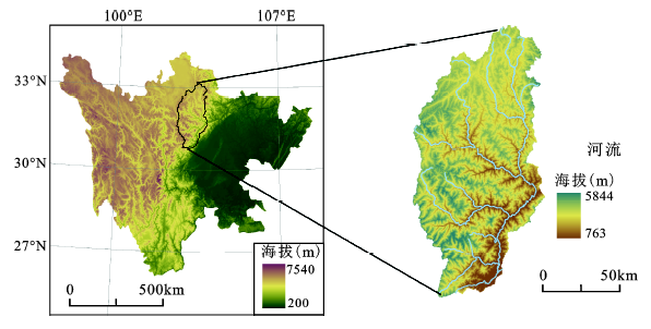
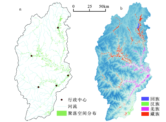
岷江上游位于31°26′N ~ 33°16′N,102°59′E ~ 104°14′E之间,地处青藏高原向四川盆地过渡地带,是藏-羌-汉-回多民族聚居共生的人文地理单元[20,21](图1)。藏族聚落生态位主要分布在海拔1 100~3 200 m,分布范围广,分布面积达562.27 km2;羌族主要位于干旱河谷和二半山地带,分布面积351.24 km2;回族聚落生态位少且分布集中;汉族主要分布在海拔小于1 600 m地带,分布面积为39.32 km2。作为中国横断山区北部干温河谷类型的典型分布区,流域内山地气候垂直分异显著,生态环境复杂,植被空间异质性独特。从河谷到山顶的气候带分布为:亚热带-山地暖温带-温带-山地寒带-山地亚寒带-山地冰川带。亚热带常绿阔叶林-灌丛(800~1 300 m)-干旱河谷小叶灌丛(1 300~2 200 m)-常绿、落叶阔叶林与针阔叶混交林(2 000~2 800 m)-云杉(Picea likiangenis)、冷杉林(Abies faxoniana)(2 800~3 600 m)-高山灌丛、草甸 (>3 600 m)。在此植被垂直带谱中,都江堰至草坡段以亚热带常绿阔叶林为山地基带,草坡以北的岷江上游干流及杂谷脑、黑水河支流以小叶灌丛为基带。
图1 岷江上游地理位置
Fig.1 The geographical location of the upper reaches of the Minjiang River
1) 基础地理数据:1999年的遥感影像数据为SPOT-2、4,包括10 m全色波段和20 m多光谱波段;2009年的遥感影像数据为SPOT-5卫星获取,包括5 m全色波段和10 m多光谱波段。影像数据覆盖整个岷江上游,成像所用传感器分别为HRV、HRVIR、HRG2,产品级别均为1A。
2) 数字高程模型(DEM):2009年的ASTER GDEM,其精度为30 m。
3) 山区聚落空间分布图:研究区共有1 667个山区聚落生态位,汉族聚落生态位为140个;羌族聚落生态位为667个;藏族聚落生态位为834个;回族聚落生态位为26个(图2)。
图2 岷江上游山区聚落生态位空间分布(a)与民族类型聚落生态位分布(b)
Fig.2 The spatial distribution(a) and nationality categories variation (b) of mountainous settlement ecological niche in the upper reaches of the Minjiang River
2.2.1 植被适宜性等级划分
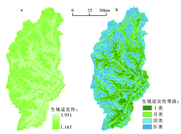
本文采用自然断点法,将研究区植被生境适宜性分为4类:Ⅰ类(3.951~2.830):植被生境适宜性最高;Ⅱ类(2.830~2.362):植被生境适宜性较高;Ⅲ类(2.362~1.894):植被生境适宜性较差;Ⅳ类(1.894~1.165):植被生境适宜性最差(图3)。
2.2.2 多水平贝叶斯模型
1) 山区聚落生态位间隙度指数
基于间隙度指数多水平贝叶斯模型[22~25],经改进后,山区聚落生态位间隙指数表达式如下:
式中:
2) 山区聚落生态位几何特征
为了消除原始数据量纲的影响,需对原始数据进行标准化[26~28]:
式中,Zi和zi分别为标准化前后的变量;m和s分别为标准化前变量的平均值和标准差。
本文聚落生态位几何特征多水平贝叶斯模型模拟分析中均采用标准化后的变量值,聚落生态位几何特征多水平贝叶斯模型表达式如下:
式中
3.1.1 山区聚落生态位间隙度指数
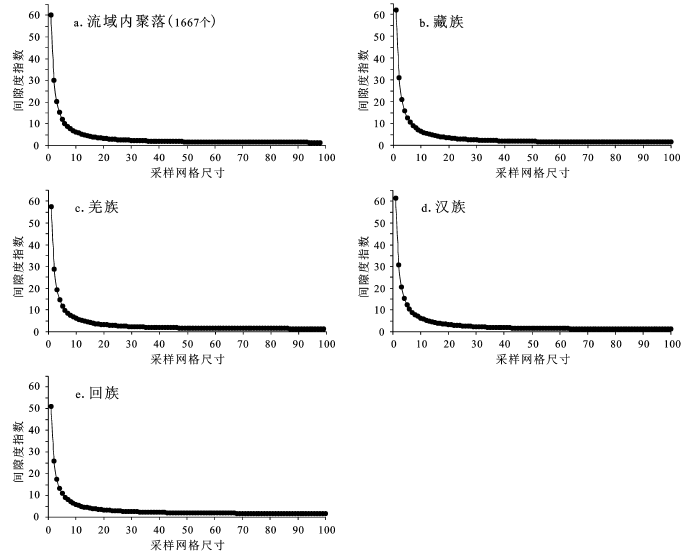
随着采样网格尺度的增加,山区聚落生态位间隙度指数呈幂指数函数递减(图4)。采样网格尺度为10(即5 m,10 × 0.5 m)时,间隙度指数曲线出现拐点,采样网格尺度小于等于10时,间隙度指数曲线下降的速率较快,采样网格尺度大于等于10时,间隙度指数下降的速率减缓,最终趋于不变,表明采样网格尺度10为岷江上游山区聚落生态位的空间变异特征尺度的特征点。汉族聚落生态位间隙度指数曲线在采样网格尺度10的曲率最大,表明其空间变异特征最为明显,而回族聚落生态位间隙度指数的曲率最小。藏-羌-汉-回族及流域内1 667个聚落生态位的间隙度指数曲线在采样网格尺度分别为70、50、50、50、60时,趋于不变,表明其空间变异减小,聚落生态位趋于空间均质分布,藏族聚落生态位空间均质分布对应的采样网格尺度最大,这与其分布范围广泛和聚落个数较多(834个)有关。
图3 岷江上游植被生境适宜性空间分布(a)及其等级分布(b)
Fig.3 The spatial distribution of vegetation habitat suitability(a) and its class (b) in the upper reaches of the Minjiang River
图4 岷江上游山区聚落生态的间隙度指数分布
Fig.4 Distributions of lacunarity index for mountainous settlement ecological niches in the upper reaches of the Minjiang River
藏族聚落生态位的初始间隙度指数为62.131,由于其分布范围广泛,对采样网格尺度十分敏感,空间分异大。该聚落生态位主要分布在海拔1 100~3 200 m,分布面积达562.27 km2。汉族聚落生态位的初始间隙度指数为61.362,与其它民族聚落生态位交错分布,对采样网格尺度较为敏感,空间分异较大,直接反映了山区汉族聚落相对于平原聚落,其空间封闭性较强。该聚落生态位主要位于海拔小于1 600 m,分布面积达39.32 km2,分布在岷江上游沿岸经济比较发达的城镇及河谷河坝地区。羌族聚落生态位的初始间隙度指数为57.426,对采样网格尺度敏感性较低,空间分异较小。该聚落生态位集中分布在海拔1 180~3 200 m范围内,主要位于以茂县为中心的干旱河谷地区和二半山地带,分布面积达351.24 km2。回族聚落生态位的初始间隙度指数为51.061,对采样网格尺度敏感性最低,空间分异最小,集中分布在海拔2 860~3 280 m的岷江干流河谷区,行政上隶属松潘县的进安镇和十里回族乡。
3.1.2 山区聚落生态位间隙度维数
多水平贝叶斯模型对山区聚落生态位间隙度维数的模拟结果表明:民族类型对山区聚落生态位的空间分异特征影响显著(表1),主要表现为:
表1 山区聚落生态位间隙度指数与采样网格尺度关系的拟合系数
Table 1 Fitting coefficients of lacunarity index for mountainous settlement ecological niches and sampling grid sizes under different nationality categories
| 系数 | 民族类型 | ||||
|---|---|---|---|---|---|
| 藏族 | 羌族 | 汉族 | 回族 | 流域内聚落(1667个) | |
| α | 61.21 [60.38, 62.05] | 56.5 [55.64, 57.32] | 60.67 [59.83, 61.51] | 49.64 [48.81, 50.47] | 59.04 [58.22, 59.89] |
| β | 0.949 [0.936, 0.961] | 0.942 [0.928, 0.955] | 0.960 [0.948, 0.973] | 0.889 [0.875, 0.903] | 0.946 [0.934, 0.959] |
1) 藏族聚落生态位的间隙度维数为0.949,空间聚簇性较低,主要位于高半山区,其分布集中偏小,基本无较大聚落形成,88.9%的聚落生态位面积小于4×10⁵m2,因为高山气候寒冷,不适宜人居住,加之交通不便,居住在高半山上的藏族聚落多为耐寒的游牧聚落,聚落生态位偏小。
2) 羌族聚落生态位的间隙度维数为0.942,空间聚簇性比藏族聚落生态位高,主要分布在低半山区和干旱河谷区,这与羌族居民生计以农业为主有关。同时,羌族在这一区域的居住历史悠久,占据着保持民族人口持续增长的高生产力区域。低半山区地势相对河谷开阔,但坡度较大,是河谷和高半山的过渡区,发展潜力受到自然环境的限制,适宜人类活动的范围较少,导致大型羌族聚落发展相对较少,只有少数地理条件优越的聚落生态位偏大。
3) 汉族聚落生态位的间隙度维数为0.960,空间聚簇性最低,主要分布于1 600 m 以下的河谷区,其分布多与政治管理以及森工的发展有关。汉族聚落生态位集中偏小,88.3%的聚落生态位集中在1.4×10⁶m2以下,其中分布最多的是在2.3×10⁴~4×10⁵m2。形成这一分布格局的原因在于岷江上游河谷深切,沟谷狭窄,山体陡峭,适宜人类开发和利用的土地资源较少,没有形成较为大型的聚落生态位。
4) 回族聚落生态位的间隙度维数为0.889,空间聚簇性较高,由于岷江上游区域地理的特殊性,在海拔较高的高原地貌区松潘县,河谷平坦,腹地开阔,适合发展大型聚落,所以位于该地区的回族聚落生态位普遍偏大,且聚落总数相对较少。流域内1 667个聚落生态位的间隙度维数为0.946,其值介于汉族与回族聚落生态位之间,空间聚簇性较低。
山区聚落位于山体的截留部分,是长期以来人与自然和谐相互耦合作用的结果。植被生境适宜性指数可反映土壤、植被、气候、和地形因子在空间上的叠加耦合作用。多水平贝叶斯模型的模拟显示:民族类型生态位的几何特征与植被生境适宜性间相关性显著(表2)。
表2 山区聚落生态位几何特征与植被生境适宜性关系的拟合系数
Table 2 Fitting coefficients of geometrical features for mountainous settlement ecological niches and vegetation habitat suitability under different nationality categories
| 山区聚落生态位 几何特征指标 | 系数 | 民族类型 | ||||
|---|---|---|---|---|---|---|
| 藏族 | 羌族 | 汉族 | 回族 | 流域内聚落(1667个) | ||
| 面积 | α | 0.545 [0.491, 0.598] | 0.422 [0.390, 0.454] | 0.377 [0.303, 0.458] | 0.616 [0.384, 0.824] | 0.441 [0.415, 0.467] |
| β | -0.00428 [-0.0937, 0.0828] | 0.109 [0.0463, 0.171] | -0.0622 [-0.258, 0.101] | 0.162 [-0.243, 0.691] | 0.119 [0.0709, 0.165] | |
| 周长 | α | 0.588 [0.532, 0.645] | 0.444 [0.411, 0.476] | 0.366 [0.294, 0.441] | 0.632 [0.439, 0.837] | 0.464 [0.437, 0.490] |
| β | -0.0775 [-0.173, 0.0172] | 0.0618 [-0.00220, 0.125] | -0.0389 [-0.203, 0.116] | 0.0275 [-0.384, 0.445] | 0.0728 [0.0260, 0.121] | |
| 周长/面积 | α | 0.590 [0.541, 0.641] | 0.610 [0.580, 0.641] | 0.455 [0.367, 0.544] | 0.481 [0.160, 0.747] | 0.601 [0.574, 0.627 ] |
| β | -0.216 [-0.303, -0.135] | -0.210 [-0.272, -0.152] | 0.515 [0.311, 0.717] | -0.336 [-0.912, 0.352] | -0.202 [-0.248, -0.153] | |
藏-羌-汉-回-聚落生态位内植被生境适宜性指数均值分别为:2.816、2.622、2.529、2.644,主要分布在Ⅰ、Ⅱ类植被生境适宜性区(图3),该区域能够提供丰富的生态系统服务功能,例如水源涵养、食物生产、土壤保护和气候调节等,是岷江上游山区理想的聚落场所。Ⅰ类植被生境适宜性区主要分布在海拔范围为2 100~2 800 m或者1 300 m以下,适宜的气候条件和土壤稳定性适合植被生长,其植被类型主要为常绿落叶阔叶混交林;Ⅱ类植被生境适宜性区位于2 800~3 600 m,良好的气候条件和土壤稳定性也较为适合植被生长,植被类型主要为针阔混交林。
3.2.1 山区聚落生态位几何表征
1) 回族聚落生态位面积、周长对植被生境适宜性的敏感性分别为0.616、0.632,面积与周长随植被生境适宜性的增加而增大,其变化系数分别为0.162、0.028。
2) 藏族聚落生态位面积、周长对植被生境适宜性的敏感性较高,其值分别为0.545、0.577,其面积和周长随植被生境适宜性的增加而减小(-0.004、-0.078)。
3) 羌族聚落生态位面积、周长对植被生境适宜性的敏感性分别为0.422、0.444,其面积和周长随植被生境适宜性的增加而增大,变化系数分别为0.109、0.061 8。
4) 汉族聚落生态位面积对植被生境适宜性的敏感性分别为0.377、0.366,面积和周长随植被生境适宜性的增加而减小(-0.062、-0.039)。
3.2.2 山区聚落生态位几何复杂程度
1) 羌族聚落生态位周长与面积的比率对植被生境适宜性的敏感性为0.610,生态位周长与面积的比率随着植被生境适宜性的增加而减小(-0.210)。
2) 藏族聚落生态位周长与面积的比率对植被生境适宜性的敏感性为0.590,其周长与面积的比率随着植被生境适宜性的增加而减小(-0.216)。
3) 回族聚落生态位周长与面积的比率对植被生境适宜性的敏感性为0.481,其周长与面积的比率随着植被生境适宜性的增加而减小(-0.336)。
4) 汉族聚落生态位周长与面积的比率对植被生境适宜性的敏感性为0.455,其周长与面积的比率随着植被生境适宜性的增加而增大(0.515)。
山区聚落生态位几何表征和几何复杂程度的计算结果表明:流域内1 667个聚落生态位面积、周长、周长与面积的比率对植被生境适宜性的敏感性(0.601)及变化趋势(-0.202),与羌族相似。这一研究结果深层次的科学价值在于:羌族聚落生态位可作为研究岷江上游山区聚落的“窗口”,有利于藏-羌-汉-回多民族共生区人地关系研究的简单化,这也是当今聚落生态研究的前沿。
表3模拟结果表明:民族类型对山区聚落生态位空间分布特征的影响显著。民族类型对山区聚落生态位间隙度指数对采样网格尺度敏感性的影响为9.212,对聚落生态位面积、周长、周长与面积的比率对植被生境适宜性敏感性的影响分别为0.247、0.242、0.190。民族类型对山区聚落生态位间隙度指数与采样网格尺度间变化关系的影响为0.622,对聚落生态位面积、周长、周长与面积的比率与植被生境适宜性间变化关系的影响分别为0.251、0.208、0.797。
表3 民族类型对山区聚落生态位空间分布特征的影响
Table 3 The effects of nationality categories on spatial distribution features of mountainous settlement ecological niches
| 影响系数 | 山区聚落生态位空间分布特征指标 | |||
|---|---|---|---|---|
| 间隙度 | 面积 | 周长 | 周长/面积 | |
| 9.212 [3.327, 25.100] | 0.247 [0.0521, 0.925] | 0.242 [0.0706, 0.763] | 0.190 [0.0374, 0669] | |
| 0.622 [0.0203, 3.168] | 0.251 [0.0264, 0.963] | 0.208 [0.0288, 0.796] | 0.797 [0.239, 2.443] | |
岷江上游聚落生态位独特的民族文化特征的形成和发展,除了受传统社会文化因素影响,其周围的地形、河流、气候、土壤和植被等因素对聚落生态位的区位选择、规模大小和外部形态均产生了重要的影响。同时,植被生境的宜居性,对岷江上游山区聚落生态位的发展方向及其形态又产生了空间引导作用。
分形和多水平贝叶斯模型,能够有效地揭示岷江上游藏-羌-回-汉聚落生态位空间分异特征,以及与植被生境适宜性的协调性,研究结果有助于山区聚落生态位的布局优化,为进一步促进山区用地的集约化利用和资源的合理配置提供有益参考。
1) 岷江上游聚落生态位的民族特征
藏-羌-回-汉聚落生态位空间聚簇程度依次为:汉<藏<羌<回。具体表现为:834个藏族聚落生态位分布于高半山区,小聚落与低聚簇性特征对应于藏民半定居和游牧生计方式;667个羌族聚落生态位主要分布在低半山区和干旱河谷区,空间聚簇性比藏族高,居民生计以农业为主;140个汉族聚落生态位分布于1 600 m 以下的河谷区,生态位面积集中偏小,空间聚簇性最低;26个回族聚落生态位集中分布在松潘县十里回族乡和进安镇,空间聚簇性较高。在流域尺度上,1 667个聚落生态位空间分异特征与藏族近一致。
2) 岷江上游聚落生态位的几何特征
聚落生态位几何面积、周长对植被生境的敏感程度依次为:回>藏>羌>汉,且羌族生态位几何面积、周长随植被生境适宜性的增加而递增。在流域尺度上,1 667个聚落生态位的几何复杂程度随植被生境适宜性的增加而递减。聚落生态位几何复杂程度对植被生境的敏感程度依次为:羌>藏>回>汉。特别是,1 667个聚落生态位几何特征对植被生境适宜性的敏感程度与羌族相似。
综上所述,藏族和羌族聚落生态位可作为认知岷江上游山区聚落的“窗口”,该“窗口”有利于揭示藏-羌-汉-回多民族共生区所蕴含的某种规律和特征,实现复杂人地系统问题的简化,这也是当今聚落生态研究的前沿。山区聚落生态位是表征山区人地关系的有效指标,本文通过分形和多水平贝叶斯模型,研究了岷江上游聚落生态位的空间尺度特征及其与植被生境适宜性的关系,在一定程度上,揭示了山区聚落生态位所蕴含的某种规律。本文仅选取自然环境因素,而对影响山区聚落生态位规模的人文因素尚待进一步研究。
The authors have declared that no competing interests exist.
| [1] |
西部大开发与聚落生态建设——以西南山区为例 [J].https://doi.org/10.3969/j.issn.1673-4831.2001.02.002 URL [本文引用: 1] 摘要
我国西部生态环境退化与广泛分布的农村聚落落后的生产方式和生活方式有密切关系。在西部大开发中 ,搞好生态环境必须与聚落建设统一规划 ,同步实施。重点应解决好环境恶劣的聚落、地方病聚落、自然保护区聚落、草场聚落、工程移民聚落。根据不同生态状况 ,可采取新建聚落、重建聚落与迁建聚落等聚落建设方略
Development of West China and the construction of settlement ecology—take the southwest mountainous area of China as an example .https://doi.org/10.3969/j.issn.1673-4831.2001.02.002 URL [本文引用: 1] 摘要
我国西部生态环境退化与广泛分布的农村聚落落后的生产方式和生活方式有密切关系。在西部大开发中 ,搞好生态环境必须与聚落建设统一规划 ,同步实施。重点应解决好环境恶劣的聚落、地方病聚落、自然保护区聚落、草场聚落、工程移民聚落。根据不同生态状况 ,可采取新建聚落、重建聚落与迁建聚落等聚落建设方略
|
| [2] |
岷江上游山区聚落生态位垂直分异研究 [J].https://doi.org/10.11821/dlxb201311011 Magsci [本文引用: 1] 摘要
以岷江上游山区聚落为研究对象,采用生态位的方法,利用遥感资料和GIS技术,提取岷江上游山区空间信息,定量研究山区聚落生态位影响尺度、人口密度及民族类型带谱垂直分异特征,并建立民族聚落生态位类型图谱。研究表明:聚落生态位地理半径随着海拔升高而增大,其数值介于300~600 m;相反,聚落生态位人口密度却随着海拔升高而递减,其数值介于200~630 人/km<sup>2</sup>;聚落生态位地理半径和人口密度的垂直分异特征,是山区居民长期适应山地环境的结果,与民族类型及其生计方式密切相关。在流域尺度上,岷江上游作为我国西南地区的一条民族廊道,聚落生态位民族类型空间格局具有典型的带谱特征:藏族和回族聚落生态位均处于河流干支流的上部,羌族聚落生态位对应于干旱河谷和V型河谷上部的低半山缓坡地带,汉族聚落生态位位于岷江上游入口处的河谷地带。
The vertual differentiation of the mountain settlement niche in the upper reaches of Minjiang River. https://doi.org/10.11821/dlxb201311011 Magsci [本文引用: 1] 摘要
以岷江上游山区聚落为研究对象,采用生态位的方法,利用遥感资料和GIS技术,提取岷江上游山区空间信息,定量研究山区聚落生态位影响尺度、人口密度及民族类型带谱垂直分异特征,并建立民族聚落生态位类型图谱。研究表明:聚落生态位地理半径随着海拔升高而增大,其数值介于300~600 m;相反,聚落生态位人口密度却随着海拔升高而递减,其数值介于200~630 人/km<sup>2</sup>;聚落生态位地理半径和人口密度的垂直分异特征,是山区居民长期适应山地环境的结果,与民族类型及其生计方式密切相关。在流域尺度上,岷江上游作为我国西南地区的一条民族廊道,聚落生态位民族类型空间格局具有典型的带谱特征:藏族和回族聚落生态位均处于河流干支流的上部,羌族聚落生态位对应于干旱河谷和V型河谷上部的低半山缓坡地带,汉族聚落生态位位于岷江上游入口处的河谷地带。
|
| [3] |
岷江上游山地生态系统的退化及其恢复与重建对策 [J].
阐述了岷江上游山地生态系统的主要特征及主要由人类活动引起的森林、草地、农用地和整个山地 生态系统环境退化现状。在此基础上,提出了岷江上游退化山地生态系统恢复与重建的对策,即加强资源和环境的合理利用和保护,提高全民环境保护意识;分区分 类治理;不同区城不同退化亚系统采取不同的技术方法。同时,就恢复与重建过程中应注意的几个问题出提出了解决的思路和方法。
Degradation of mountain ecosystem in the Upper Reaches of the Minjiang River and coutermeasures for their rehabilitation and Reconstruction.
阐述了岷江上游山地生态系统的主要特征及主要由人类活动引起的森林、草地、农用地和整个山地 生态系统环境退化现状。在此基础上,提出了岷江上游退化山地生态系统恢复与重建的对策,即加强资源和环境的合理利用和保护,提高全民环境保护意识;分区分 类治理;不同区城不同退化亚系统采取不同的技术方法。同时,就恢复与重建过程中应注意的几个问题出提出了解决的思路和方法。
|
| [4] |
山区人口与环境互动关系的初步研究 [J].A preliminary study on the interactive relationship between population and environment in mountains. |
| [5] |
吉林省近300年来聚落格局演变 [J].The pattern evoluation of settlements in Jilin province over the past 300 years. |
| [6] |
基于GIS的乡村聚落空间分布规律研究-以陕北榆林地区为例 [J].URL 摘要
本研究以地理信息系统为基本技术手段 ,以国家 1:2 5万基础地理数据库等数字信息为主要信息源 ,对陕北榆林地区乡村聚落的空间分布规律与区位特征进行了探讨。通过综合应用基于GIS的缓冲区分析、多层面的复合分析等空间分析方法 ,揭示了该地区乡村聚落的空间分布受自然条件与人为因素影响的基本特征。研究结果可望为该地区的城乡发展规划提供有益的借鉴资料。
A GIS based research on the distribution of rural settlements-Taking Yulin area as an example. URL 摘要
本研究以地理信息系统为基本技术手段 ,以国家 1:2 5万基础地理数据库等数字信息为主要信息源 ,对陕北榆林地区乡村聚落的空间分布规律与区位特征进行了探讨。通过综合应用基于GIS的缓冲区分析、多层面的复合分析等空间分析方法 ,揭示了该地区乡村聚落的空间分布受自然条件与人为因素影响的基本特征。研究结果可望为该地区的城乡发展规划提供有益的借鉴资料。
|
| [7] |
Modelling residential location choice in an area with spatial barriers [J].https://doi.org/10.1007/s001680200094 URL 摘要
A model is presented for residential location choice in rural areas with spatial barriers. We address the problem through comparative static analysis focusing on how residential location choices are affected by a new road link across the spatial barrier. We proceed through a probability theoretical approach: choose a family of utility functions representing every possible location, and equip this family with a probability measure. Then choose a representative within an equivalence class of utility functions, and represent the probability distribution by a parametrized family of distributions. Our analysis demonstrates that investments in new road links do not necessarily represent an adequate instrument for achieving ambitions in regional policy. We identify reasonable situations where a new road link could just as easily generate net migration from the area in which the investments are directed. In general, our analysis demonstrates how agglomeration and centralisation tendencies can be considerably affected by transportation infrastructure innovations.
|
| [8] |
Suitability evaluation of population and settlements spatial layout after Wenchuan Earthquake [J].https://doi.org/10.1007/s11442-011-0862-5 URL Magsci [本文引用: 1] 摘要
The suitability evaluation of population and settlements spatial layout in the mountainous areas is an important basis on which the scale of population and settlement after Wenchuan Earthquake is determined. Based on the statistical data of field research, this paper chooses 1264 towns in 51 counties as the scope of evaluation, selects eight indices in the evaluation index system which includes post-disaster population scale, population density, urbanization rate, the percentage of migrant workers, death rate by earthquake, the percentage of minorities, elevation-slope integrated terrain and comprehensive geological condition. Besides, this paper uses AHP supported by entropy technique and fuzzy membership function model to calculate the suitability evaluation index and then divides the disaster areas into five types: highly suitable area (area accounted for 11.03%), relatively highly suitable area (15.29%), moderately suitable area (29%), less suitable area (30.08%) and unsuitable area (14.6%). According to the result of suitability evaluation, this paper puts forward several suggestions for the reconstruction as follows: the urban system and the building of new countryside should be guided by the suitability evaluation subareas; post-earthquake reconstruction avoids zones near Longmenshan fracture and high-mountain gorge areas as far as possible; the scale of population and settlement should not exceed the capacity of resources and environment; population should be resettled as close as possible by considering adequately the heterogenicity and homogeneity of regional nationality culture characteristics; densely resettle the people at plains and hilly areas; encourage the migrant workers settle in the working place with their families voluntarily; and urban system reconstruction such as industry layout and important projects of lifeline should be guided by the spatial layout suitability evaluation.
|
| [9] |
Changing ruralities, changing landscapes: exploring social recomposition using a multi-scale approach [J].https://doi.org/10.1016/S0743-0167(03)00006-8 URL [本文引用: 1] 摘要
ABSTRACT Changes in agricultural practices have led to declines in the farming population and significant changes within the landscape. Paradoxically, many rural areas are recording significant demographic growth. Given the extent of rural areas experiencing these changes, little attention has been devoted to the relationship between rural migration processes and landscape developments. Therefore, the various rural dynamics resulting from these phenomena merit closer investigation. Moreover, we should explore these complex processes at scales where they are most evident. Through the multi-scale research approach used in this study, these processes are investigated in their regional, local, and domestic contexts.As shown by regional typological outlines, the great diversity of the rural areas indicates an increasing dissociation between the agricultural and socio-demographic trajectories. From our local-scale study, changes in lot occupation revealed new residential settlement patterns induced by an influx of in-migrants. Specific landscape characteristics seem to be a determining force shaping these population flows. At the same time, these population movements have dissimilar influences on evolving landscape dynamics. With the exception of isolated agricultural abandonment trajectories, migrant relocation does not seem to affect specific local-scale land use development. However, it is significantly associated with individual domestic practices. These practices are indicative of the migrant's identity in the rural landscape; further, they suggest specific values for the landscape's qualitative dimensions. These emerging urban and non-farming interests in rural landscapes challenge planning policies to guide the landscape's evolution for the benefit of its “producers” and “consumers”.
|
| [10] |
Settlement models,land use and visibility in rural landscapes:Two case in Greece [J].https://doi.org/10.1016/j.landurbplan.2006.09.004 URL Magsci [本文引用: 1] 摘要
<h2 class="secHeading" id="section_abstract">Abstract</h2><p id="">Settlement models and geographical site analysis contribute to the understanding of the ecological functioning of the landscape. In assessing land qualities, there is an increasing interest to include visibility analysis. The hypothesis is that settlements traditionally locate on places where the more fertile and intensively used grounds can easily be controlled. This can be tested in traditional landscapes where the initial settlement pattern and associated visibility are not very disturbed. This paper analyses two cases of traditional settlements in Greece, on the island of Paros (Cyclades) and on the Lassithi plain (Crete), which are exemplary for two distinct settlement models, respectively the island and the basin model. The relationship between settlement pattern, land use zoning and landscape visibility is analysed using a geographical information system (GIS). Cumulative and single viewshed analysis are performed for all settlements in the study areas using different distance zones, one in the visible proximity up to 1.2 km and one more extended in the landscape up to 4.7 km. Both cases show great degree of visual control of the territory. Intensively used land is significantly more visible. The relationship between visibility and land use varies however with the viewing distance and settlement model. Visibility is a factor explaining the settlement pattern.</p>
|
| [11] |
|
| [12] |
Two village ecosystems in the upper Minjiang River:A comparison of energy flow [J].
By using the concept of emergy and method of emergy analysis, this paper has studied two mountain settlement (village) ecosystems in two aspects: input and output of energy in the agro-systems and the use of fuel energy. The result reveals that the settlement agro-system in the valley of Minjiang River is better in both structure and function than that at the so-called half-high mountain. The former one is higher than the latter one regarding such indices as emergy yield ratio, labor productivity of emergy and emergy sustainable index, but lower than the latter one regarding environmental loading ratio. In terms of fuel emergy, the settlement in the valley enjoys more diversified sources and is less depending on bio-energy while the settlement at the half-high mountain has only one source (i. e. fuel wood), much depending on bio-energy, may exert a greater pressure on environment.
|
| [13] |
岷江上游山区聚落生态位及其模型 [J].
以生态位基本理论为基础,提出了山区聚落生态位的概念,即山区聚落生态位反映聚落在山地垂直方向上所处的空间位置及人类生活所能利用的资源空间。构建了山区聚落生态位宽度计测模型,以岷江上游杂谷脑河段上下孟沟为例,计算了区内12个聚落的生态位宽度。结果表明,在该聚落群的聚落生态位计算中,自然因素占主导地位,经济因素次之,社会因素影响最小;海拔高度为1900~2600 m时,山区聚落生态位宽度为0.03~0.11,海拔高度为>2600~3100 m时,山区聚落生态位宽度大多分布在0.12~0.13之间,聚落生态位随海拔升高呈增大趋势。山区聚落生态位研究可为揭示山区人地关系以及聚落空间规划提供新的评估方法。
Econiche of the settlements in mountains of the upper reaches of Min river and its mathematical model.
以生态位基本理论为基础,提出了山区聚落生态位的概念,即山区聚落生态位反映聚落在山地垂直方向上所处的空间位置及人类生活所能利用的资源空间。构建了山区聚落生态位宽度计测模型,以岷江上游杂谷脑河段上下孟沟为例,计算了区内12个聚落的生态位宽度。结果表明,在该聚落群的聚落生态位计算中,自然因素占主导地位,经济因素次之,社会因素影响最小;海拔高度为1900~2600 m时,山区聚落生态位宽度为0.03~0.11,海拔高度为>2600~3100 m时,山区聚落生态位宽度大多分布在0.12~0.13之间,聚落生态位随海拔升高呈增大趋势。山区聚落生态位研究可为揭示山区人地关系以及聚落空间规划提供新的评估方法。
|
| [14] |
岷江上游山区聚落生态位地域边界划分与垂直分异分析 [J].https://doi.org/10.3969/j.issn.1673-4831.2013.05.005 URL Magsci 摘要
山区聚落生态位是当地居民长期适应山地自然环境的结果,涵盖了人类居所在山地生态系统中所处的地理位置及居民生计所能利用的资源空间。基于SPOT-5遥感数据和GIS技术,对岷江上游山区聚落生态位边界进行甄别,提出了山区聚落生态位地域边界的划分方法,并对其分异特征进行定量分析。结果表明,河流、山脚、山沟、图像纹理和色差等因素对边界划分具有指示意义,是界定山区聚落生态位地域范围的关键因子;岷江上游山区聚落生态位地域面积介于2.27~528.67 hm<sup>2</sup>之间,且随着海拔升高而增大;在<1 600 m海拔段,聚落生态位的增速较小,当海拔高度超过1 600 m时,聚落生态位的增速明显增加。
Delineation of geographical boundaries of settlement niches in mountains of the upper reaches of the Min river and analysis of their vertical differentiation. https://doi.org/10.3969/j.issn.1673-4831.2013.05.005 URL Magsci 摘要
山区聚落生态位是当地居民长期适应山地自然环境的结果,涵盖了人类居所在山地生态系统中所处的地理位置及居民生计所能利用的资源空间。基于SPOT-5遥感数据和GIS技术,对岷江上游山区聚落生态位边界进行甄别,提出了山区聚落生态位地域边界的划分方法,并对其分异特征进行定量分析。结果表明,河流、山脚、山沟、图像纹理和色差等因素对边界划分具有指示意义,是界定山区聚落生态位地域范围的关键因子;岷江上游山区聚落生态位地域面积介于2.27~528.67 hm<sup>2</sup>之间,且随着海拔升高而增大;在<1 600 m海拔段,聚落生态位的增速较小,当海拔高度超过1 600 m时,聚落生态位的增速明显增加。
|
| [15] |
岷江上游聚落分布规律及其生态特征——以四川理县为例 [J].https://doi.org/10.3969/j.issn.1004-8227.2004.01.013 URL [本文引用: 1] 摘要
聚落是人类生存的重要空间形式,而聚落生态系统是人类生态系统的基本功能单位.山区聚落生态系统是山区人地关系的集中反映.岷江上游既是一个多民族聚居区,又是典型的生态环境脆弱区.岷江上游特殊的地理环境和生态条件决定了聚落垂直分布的超常规性及其与自然垂直生态带的适应性.生态脆弱区聚落的发展受到耕地、能源和水资源的制约.聚落生态系统是区域生态系统的重要组成部分.聚落生态系统质量的提高既有赖于区域环境的改善,又可以为区域环境的改善创造条件.目前,由于人口的大量增加,人类活动的加剧,岷江上游聚落生态系统面临着更加严峻的生态和经济问题.要解决这些问题,除采取区域性的措施外(如停止对天然林的砍伐),还必须在聚落生态系统的水平上采取适当的对策.
Distribution of human settlements in the upstream Minjiang River and their ecological characteristics-a case study of Lixian county. https://doi.org/10.3969/j.issn.1004-8227.2004.01.013 URL [本文引用: 1] 摘要
聚落是人类生存的重要空间形式,而聚落生态系统是人类生态系统的基本功能单位.山区聚落生态系统是山区人地关系的集中反映.岷江上游既是一个多民族聚居区,又是典型的生态环境脆弱区.岷江上游特殊的地理环境和生态条件决定了聚落垂直分布的超常规性及其与自然垂直生态带的适应性.生态脆弱区聚落的发展受到耕地、能源和水资源的制约.聚落生态系统是区域生态系统的重要组成部分.聚落生态系统质量的提高既有赖于区域环境的改善,又可以为区域环境的改善创造条件.目前,由于人口的大量增加,人类活动的加剧,岷江上游聚落生态系统面临着更加严峻的生态和经济问题.要解决这些问题,除采取区域性的措施外(如停止对天然林的砍伐),还必须在聚落生态系统的水平上采取适当的对策.
|
| [16] |
川西南山地民族聚落生态研究——以米易县麦地村为例 [J].https://doi.org/10.3969/j.issn.1008-2786.2005.01.014 URL [本文引用: 1] 摘要
麦地村位于四川省米易县,其聚落生态系统由庭院生态亚系统(人工生态系统),农田生态亚系统(半人工生态系统),森林生态亚系统(自然生态系统),荒地生态亚系统(自然生态系统)等构成。作为一个聚落生态系统,麦地村缺乏与外界的交流,包括物质、文化与人员方面的交流。为减少薪柴消费对现有森林资源带来的负面影响,除发展经济林和水土保持林外,应在荒山荒坡和裸地上大力种植薪炭林。同时,国家应在发展沼气、推广省柴灶、使用电能方面给予补助。
Ecological studies of human settlements of ethnic groups in southwestern Sichuan--A case study of maidi village, Miyi county. https://doi.org/10.3969/j.issn.1008-2786.2005.01.014 URL [本文引用: 1] 摘要
麦地村位于四川省米易县,其聚落生态系统由庭院生态亚系统(人工生态系统),农田生态亚系统(半人工生态系统),森林生态亚系统(自然生态系统),荒地生态亚系统(自然生态系统)等构成。作为一个聚落生态系统,麦地村缺乏与外界的交流,包括物质、文化与人员方面的交流。为减少薪柴消费对现有森林资源带来的负面影响,除发展经济林和水土保持林外,应在荒山荒坡和裸地上大力种植薪炭林。同时,国家应在发展沼气、推广省柴灶、使用电能方面给予补助。
|
| [17] |
岷江上游山区杂谷脑河流域聚落变迁规律及其驱动机制实证研究 [J].An empirical research on evolution characteristics and dynamic mechanism of rural settlements in mountain areas of the Upstream of Minjiang River. |
| [18] |
Assessment of habitat suitability in the Upper Reaches of the Min River in China [J].https://doi.org/10.1007/s11629-013-2662-0 URL [本文引用: 1] 摘要
Habitat richness influences and even determines biological diversity. Plant habitat suitability assessment can provide technical guidance and information support for ecological restoration. Thirteen factors in three categories of terrain, meteorology and soil were chosen to build a habitat suitability assessment index framework in the Upper Reaches of the Min River, based on the local natural environment and the actual influencing factors of vegetative growth. Combined with the Analytic Hierarchy Process(AHP) and entropy method, which were used to calculate weights of indexes, habitat suitability was studied by using a multi-objective linear weighting model and geographic information systems(GIS) spatial analysis techniques. The assessment results are as follows: Altitude, soil stability, aspect and slope have more important effects on plant habitat suitability in the Upper Reaches of the Min River, and their weights are 0.311, 0.260, 0.198 and 0.125, respectively. Suitable and sub-suitable habitats cover 4431.80 km2 and 6171.12 km2, respectively; most of which are distributed along both sides of rivers and have higher suitability. Unsuitable habitats cover the largest area(6679.76 km2), accounting for 29.83% of the whole area; and the worst unsuitable habitats are 5107.23 km2(22.81%); they account for more than half of the studyarea. These results indicate that the plant habitat in the Upper Reaches of the Min River is poor and ecological restoration is both urgent and difficult. Therefore, based on the principle of taking measures suitable to the habitat in ecological restoration projects, ecological and engineering measures should be combined to have better effects, while increasing the strength of ecological protection.
|
| [19] |
中国自然地理学的发展趋势与优先领域 [J].
科学研究需要把握学科的发展趋势和优先领域。影响自然地理学发展的主要因素包括社会需求、学科自身性质和其他学科的影响。自然地理学当前发展态势包括积极参与多学科研究计划、新思维和新领域的出现、模式(model)作为重要手段、在认识自然演变机理的基础上解释空间格局、成果得到更广泛应用等。未来自然地理学将出现更加综合、在全球变化的高度上进行研究、更深入地揭示过程及其动态变化的机理机制、更多运用高新技术武装、更加密切地为实现区域可持续发展服务等趋势。中国自然地理学未来的优先领域是:人类活动对全球变化的影响及适应,土地变化过程及其生态环境效应与调控,城市化过程及其资源环境效应与调控,流域地表过程与综合管理,土壤演变过程及其对土壤质量的影响,资源与生态的可持续性,污染物的区域环境过程、健康风险与控制,灾害形成机制与综合风险管理,生态系统服务功能综合评估。要加强特殊自然地理区域的综合研究,包括区域综合理论研究,寒区现代地表过程对气候变化的响应,干旱化过程与人地关系演化,湿地生态过程、服务功能与恢复模式,风成环境与风成过程及其调控,喀斯特生态系统的演变过程与可持续性,青藏高原生态屏障作用及区域生态安全,山地灾害与环境相互作用及区域生态安全。
Future development trends and priority areas of physical geography in China.
科学研究需要把握学科的发展趋势和优先领域。影响自然地理学发展的主要因素包括社会需求、学科自身性质和其他学科的影响。自然地理学当前发展态势包括积极参与多学科研究计划、新思维和新领域的出现、模式(model)作为重要手段、在认识自然演变机理的基础上解释空间格局、成果得到更广泛应用等。未来自然地理学将出现更加综合、在全球变化的高度上进行研究、更深入地揭示过程及其动态变化的机理机制、更多运用高新技术武装、更加密切地为实现区域可持续发展服务等趋势。中国自然地理学未来的优先领域是:人类活动对全球变化的影响及适应,土地变化过程及其生态环境效应与调控,城市化过程及其资源环境效应与调控,流域地表过程与综合管理,土壤演变过程及其对土壤质量的影响,资源与生态的可持续性,污染物的区域环境过程、健康风险与控制,灾害形成机制与综合风险管理,生态系统服务功能综合评估。要加强特殊自然地理区域的综合研究,包括区域综合理论研究,寒区现代地表过程对气候变化的响应,干旱化过程与人地关系演化,湿地生态过程、服务功能与恢复模式,风成环境与风成过程及其调控,喀斯特生态系统的演变过程与可持续性,青藏高原生态屏障作用及区域生态安全,山地灾害与环境相互作用及区域生态安全。
|
| [20] |
|
| [21] |
基于地形起伏度的山区人口密度修正-以岷江上游为例 [J].https://doi.org/10.1007/s11769-002-0041-9 URL Magsci [本文引用: 1] 摘要
<p>山区人口承载能力评价是山区国土空间管理的基础之一,而准确的人口密度数据是正确评价人口承载能力的基础。传统的人口密度算法并未考虑地形起伏度对人口分布带来的影响,不能客观反映山区人口聚集程度。引入地形起伏度、海拔高度因子,选择岷江上游作为研究区,首先运用GIS 技术提取地形起伏度,再运用SPSS软件对人口密度与地形起伏度相关性进行分析,确定县域不同地形起伏度与海拔人居适宜标准,剔除阈值以外不适宜人口聚居的面积,对人口密度进行修正。研究结果表明:① 岷江上游人口分布受地形起伏度的影响显著,二者的对数曲线拟合度为0.89,汶川县、茂县、理县、黑水县与松潘县地形起伏度与人口分布的相关性分别为:0.841、0.773、0.643、0.696 和0.730;② 应用地形起伏度对岷江上游人口密度修正,为真实反映山区人口密度提供了新的考量依据,剔除了人口密度空间噪音,5县地形起伏度与海拔适宜标准分别为:汶川3.2°和3 693 m,茂县4°和4 033 m,理县4.3°和3 790 m,黑水4.4°和3 853 m、松潘4.2°和3 966 m;地形起伏度高值区面积越大,修正前后的人口密度偏差越大,地形起伏度较大的理县和黑水县修正后的人口密度分别提高了7.8倍和5.6倍;地形起伏度较低的汶川县与茂县修正后人口密度仅分别提高2.3倍与2.4倍;③ 岷江上游人口潜在压力大,不同区域应因地制宜,汶川和茂县采取重点集约发展战略,理县和黑水县采取适度开发战略,松潘县应采取恢复与保护生态策略。</p>
Population density correction method in mountain areas based on relief degree of land surface:A case study in the Upper Minjiang River Basin. https://doi.org/10.1007/s11769-002-0041-9 URL Magsci [本文引用: 1] 摘要
<p>山区人口承载能力评价是山区国土空间管理的基础之一,而准确的人口密度数据是正确评价人口承载能力的基础。传统的人口密度算法并未考虑地形起伏度对人口分布带来的影响,不能客观反映山区人口聚集程度。引入地形起伏度、海拔高度因子,选择岷江上游作为研究区,首先运用GIS 技术提取地形起伏度,再运用SPSS软件对人口密度与地形起伏度相关性进行分析,确定县域不同地形起伏度与海拔人居适宜标准,剔除阈值以外不适宜人口聚居的面积,对人口密度进行修正。研究结果表明:① 岷江上游人口分布受地形起伏度的影响显著,二者的对数曲线拟合度为0.89,汶川县、茂县、理县、黑水县与松潘县地形起伏度与人口分布的相关性分别为:0.841、0.773、0.643、0.696 和0.730;② 应用地形起伏度对岷江上游人口密度修正,为真实反映山区人口密度提供了新的考量依据,剔除了人口密度空间噪音,5县地形起伏度与海拔适宜标准分别为:汶川3.2°和3 693 m,茂县4°和4 033 m,理县4.3°和3 790 m,黑水4.4°和3 853 m、松潘4.2°和3 966 m;地形起伏度高值区面积越大,修正前后的人口密度偏差越大,地形起伏度较大的理县和黑水县修正后的人口密度分别提高了7.8倍和5.6倍;地形起伏度较低的汶川县与茂县修正后人口密度仅分别提高2.3倍与2.4倍;③ 岷江上游人口潜在压力大,不同区域应因地制宜,汶川和茂县采取重点集约发展战略,理县和黑水县采取适度开发战略,松潘县应采取恢复与保护生态策略。</p>
|
| [22] |
A multiscale analysis of ecosystem services supply in the NW Iberian Peninsula from a functional perspective [J].https://doi.org/10.1016/j.ecolind.2014.10.027 URL [本文引用: 1] 摘要
In recent years, the assessment of ecosystem services (ES) supply has been based on the use of Land Use/Land Cover (LULC) data as proxies for spatial representation of ecosystems. Nevertheless, some shortcomings of this method, such as uncertainties derived from generalization of the ecosystem types and assumptions of invariance across spatial scales, indicate the need for new approaches. Such approaches could be aimed at improving knowledge of the relationships between ecosystem services and landscape structure and the spatial characteristics of ES patterns. In this study, we propose an integrative approach that involves the generation and analysis of continuous maps representing the supply of five ES potentially related to the amount of biomass. Five remote sensing images of the Northwestern Iberian Peninsula, obtained with Landsat-5 TM, were used to generate a proxy for net primary production by combining the normalized difference vegetation index (NDVI) of each image to calculate a NDVI index that could act as a potential indicator of some ecosystem services. This information was combined with three variables terrain slope, population density and occurrence of protected areas to produce spatial models for the five ES and eventually a series of five supply maps. Food, materials and energy provision services showed a clustered pattern, with high supply values in flat zones and areas with high population densities. In contrast, mass flow and climate regulation services were more widely distributed throughout the study area. The five ecosystem service patterns were analyzed at different scales by two methods: lacunarity and four term local quadrat variance (4TLQV) analysis. These methods revealed differences in the spatial pattern: lacunarity analysis was useful for detection of scale thresholds at the local level, whereas 4TLQV was more sensitive to scale thresholds at larger spatial levels. Thus, the variance analysis yielded higher values for larger windows sizes, particularly for provisioning services. The results demonstrated the suitability of the proposed approach for the spatially explicit modeling of ecosystem services, avoiding the uncertainty of other assessments such as those based on LULC data, and for the exploratory analysis of ES supply from a spatial point of view.
|
| [23] |
Analysis of spatial scales for ecosystem services: Application of the lacunarity concept at landscape level in Galicia (NW Spain) [J].https://doi.org/10.1016/j.ecolind.2013.09.010 URL 摘要
Ecosystem services research has become important in fields such as ecology and land planning in recent years. Several authors have emphasized the need to evaluate these services from a spatial perspective. The spatial distribution of the resources and processes that provide ecosystems have also been considered in relation to landscape. Because ecosystem services are provided by different ecological processes, the spatial scales probably also differ; this aspect may be of interest for analyzing the provision flow. In this study, we analyzed the spatial pattern of six services that are important in the study area (in Galicia, NW Spain). We first identified the landscape elements associated with these services, defining them as ecosystem service providers (ESP). To represent the ecosystem, we initially used cartographic information based on land use/land cover (LULC) and then generated two different raster ESP data sets: (i) binary and (ii) greyscale. We then explored the spatial patterns of ESP by lacunarity analysis, which is often used to study fractal elements, and by selecting landscape metrics. The results suggest that the spatial patterns of ecosystem services occur at different scales. We observed a strong relationship between lacunarity values and the different distribution patterns of ESP. Multiscale effects were also associated with changes in lacunarity values. Application of different spatial analysis techniques to study the relationships between landscape structure and service providers should provide a better understanding of service provision and enable evaluation of the ecological integrity of landscapes.
|
| [24] |
Lacunarity analysis of raster datasets and 1D, 2D, and 3D point patterns [J].https://doi.org/10.1016/j.cageo.2009.04.001 URL 摘要
Spatial scale plays an important role in many fields. As a scale-dependent measure for spatial heterogeneity, lacunarity describes the distribution of gaps within a set at multiple scales. In Earth science, environmental science, and ecology, lacunarity has been increasingly used for multiscale modeling of spatial patterns. This paper presents the development and implementation of a geographic information system (GIS) software extension for lacunarity analysis of raster datasets and 1D, 2D, and 3D point patterns. Depending on the application requirement, lacunarity analysis can be performed in two modes: global mode or local mode. The extension works for: (1) binary (1-bit) and grey-scale datasets in any raster format supported by ArcGIS and (2) 1D, 2D, and 3D point datasets as shapefiles or geodatabase feature classes. For more effective measurement of lacunarity for different patterns or processes in raster datasets, the extension allows users to define an area of interest (AOI) in four different ways, including using a polygon in an existing feature layer. Additionally, directionality can be taken into account when grey-scale datasets are used for local lacunarity analysis. The methodology and graphical user interface (GUI) are described. The application of the extension is demonstrated using both simulated and real datasets, including Brodatz texture images, a Spaceborne Imaging Radar (SIR-C) image, simulated 1D points on a drainage network, and 3D random and clustered point patterns. The options of lacunarity analysis and the effects of polyline arrangement on lacunarity of 1D points are also discussed. Results from sample data suggest that the lacunarity analysis extension can be used for efficient modeling of spatial patterns at multiple scales.
|
| [25] |
科尔沁沙地景观研究中的尺度效应 [J].Scale effects of landscape research in Kerqin Sandy Land. |
| [26] |
多水平贝叶斯模型预测森林土壤全氮 [J].https://doi.org/10.3321/j.issn:1000-0933.2009.10.059 URL Magsci [本文引用: 1] 摘要
多水平贝叶斯方法阐明了预测中观测值、模型和参数的不确定性,被越来越多的生态学家所使用。应用多水平贝叶斯方法建立了北京八达岭地区森林土壤全氮模型,分析了模型参数及其不确定性,并对该区不同土壤层(A、B、C)全氮含量进行了预测。得到如下结论:(1)该区森林土壤全氮多水平贝叶斯模型为yi~N(β0j\[i\],k\[j\]+β1j\[i\],k\[j\]xi,σ2y)。(2)对模型参数和其曲线不确定性分析表明,该模型能够很好的预测该区土壤全氮含量。(3)模型预测表明:土壤A层,随着海拔的增加,全氮含量递增。土壤B层,随着海拔的升高,植被类型0、1、2、3土壤全氮含量递增,而植被类型4土壤全氮含量出现递减现象。土壤C层,随着海拔的增加,植被类型0土壤全氮含量递增,而植被类型1、2、3、4土壤全氮含量均表现为递减。各植被类型土壤全氮含量都随着土层的深度而减少。
Hierarchical bayesian model for predicting the soil Nitrogen of forest. https://doi.org/10.3321/j.issn:1000-0933.2009.10.059 URL Magsci [本文引用: 1] 摘要
多水平贝叶斯方法阐明了预测中观测值、模型和参数的不确定性,被越来越多的生态学家所使用。应用多水平贝叶斯方法建立了北京八达岭地区森林土壤全氮模型,分析了模型参数及其不确定性,并对该区不同土壤层(A、B、C)全氮含量进行了预测。得到如下结论:(1)该区森林土壤全氮多水平贝叶斯模型为yi~N(β0j\[i\],k\[j\]+β1j\[i\],k\[j\]xi,σ2y)。(2)对模型参数和其曲线不确定性分析表明,该模型能够很好的预测该区土壤全氮含量。(3)模型预测表明:土壤A层,随着海拔的增加,全氮含量递增。土壤B层,随着海拔的升高,植被类型0、1、2、3土壤全氮含量递增,而植被类型4土壤全氮含量出现递减现象。土壤C层,随着海拔的增加,植被类型0土壤全氮含量递增,而植被类型1、2、3、4土壤全氮含量均表现为递减。各植被类型土壤全氮含量都随着土层的深度而减少。
|
| [27] |
Data analysis using regression and multilevel/hierarchical models [M].
|
| [28] |
Water yield, nitrogen and sediment retentions in Northern Japan (Teshio river watershed): land use change scenarios analysis, https://doi.org/10.1007/s11027-014-9574-3 URL [本文引用: 1] 摘要
We investigated the effects of changing land use on water yield, and nitrogen (N) and sediment retentions in the Teshio river watershed in northern Japan. The Land Use and it Effects (CLUE) model was used to predict land use change and multilevel Bayesian analysis was used to quantify relationships between water quality components and topographical slope. The Soil and Water Assessment Tool (SWAT) hydrology model was used to simulate water yield, N and sediment retentions under land use change scenarios. Most of the study area was covered by forest in 1976, 2006 and 2036, with rice fields totally converted to farmland by 2036. There were positive correlations between water yield, inorganic-N yield, sediment yield and organic-N yield and topographical slope, but there was negative correlation between nitrate nitrogen (NO 3 -N) in the bottom of soil profile and topographical slope. Sediment and organic-N yields of forest were less than those of other land uses. Water yield, organic-N and sediment retentions were largest in the southeast of the study watershed, while the inorganic-N retention was highest along the riverine area. In comparison with the 1976 land use pattern, water yield sediment retention and organic-N retention decreased under 2006 and 2036 land use patterns while inorganic-N retention increased. We conclude that planning a comprehensive adaptation and mitigation program (e.g. establishing riparian zones, planning nutrient management practices and integrating systematic conservation planning into agricultural expansion) is necessary to avoid negative impacts of land use change on water yield, N and sediment retentions in the watershed.
|

/
| 〈 |
|
〉 |