谭雪兰 , 安悦
, 安悦
Tan Xuelan, An Yue
中图分类号: K902
文献标识码: A
文章编号: 1000-0690(2018)10-1707-08
通讯作者:
收稿日期: 2018-03-13
修回日期: 2018-08-9
网络出版日期: 2018-12-12
版权声明: 2018 《地理科学》编辑部 本文是开放获取期刊文献,在以下情况下可以自由使用:学术研究、学术交流、科研教学等,但不允许用于商业目的.
基金资助:
作者简介:
作者简介:谭雪兰(1978-),女,湖南茶陵人,博士后,副教授,博士生导师,主要从事城乡规划、乡村地理及乡村土地利用研究。 E-mail:txl780120@163.com
展开
摘要
以江南丘陵湖南地区为研究对象,通过对18个抽样村进行实地走访与问卷调查,从乡村聚落的居住条件、居住设施和乡村居民的生产生活形态等方面,探讨江南丘陵湖南地区乡村聚落空间地域分异特征与规律。研究表明:乡村聚落研究是江南丘陵地区乡村聚落空间布局优化与调控的基础。由于地域范围广泛,区域内的资源禀赋与地域组合、经济发展基础、文化传统等条件差异悬殊,因此江南丘陵湖南地区乡村聚落发展的地域分异规律较为明显,在聚落空间格局(规模、密度、形态)、居住条件(住房面积、住房结构、建筑特色)、居住设施(道路、饮水安全、网络电视开通率等基础与公共服务设施)和生产生活形态等方面呈现出较为显著的盆地-丘陵-低山区、发达-欠发达-落后、近郊-远郊-偏远等地貌、经济、区位梯度差异。
关键词:
Abstract
In recent years, with the rapid industrialization and urbanization in China, the rapid development of the rural economy and the increase in the incomes of peasants have brought tremendous changes in the production, living spaces, structures and functions of rural settlements, and serious problems regarding the ecological environment. The smooth implementation of urban and rural development strategies will be seriously affected and constrained by these changes. Rural settlement spatial structure reorganization, the integration of urban and rural areas, the evolution of rural settlement spatial patterns and other fields have been hot issues in recent academic research. The method of participatory rural appraisal was adopted in this study. Through field visits and survey questionnaires conducted in 18 sample villages in the south of the Yangtze River of Hunan Province, data on the living conditions and patterns, the facilities for settlements and production, the living patterns of rural residents, and the characteristics and laws of the regional differentiation of rural settlement spaces were collected and analyzed. The results show that the spatial patterns of rural settlements are the basis for the optimization and regulation of rural settlement spatial distributions in the hilly areas of the south of the Yangtze River. Due to the great disparity in resource endowments and geographical combinations, the basis of economic development and cultural tradition in the area, and wide geographical scope, the regional differentiation of rural settlement development in Hunan's hilly areas are more obvious. The regional differentiation rule of the rural settlements in the south of the Yangtze River of China is also evident. Gradient differences lie in the pattern characteristics (size, density, shape), living conditions (housing area, housing structure, architectural features), living facilities (roads, drinking water safety, opening rates of network television, and other basic and public service facilities), production and life forms in the area of basin-hilly-low mountainous , developed-underdeveloped- backward, suburban-outher suburban-remote landforms.
Keywords:
乡村聚落是乡村聚落地理研究的核心问题之一,也是人地关系地域体系研究的重要领域之一[1,2,3]。近年来,随着中国工业化和城镇化的快速推进,农村经济的快速发展及农民收入的增加,给乡村聚落生产与生活的空间、结构及功能带来了巨大的变化,乡村聚落发展逐渐得到了乡村聚落地理学家的广泛关注[4,5,6]。目前,国内外学者对乡村聚落发展的地域分异特征、聚落类型、影响因素及优化调控等进行了大量的研究[7,8,9,10,11,12],并取得了较为丰硕的成果。从已有研究看,在研究方法方面,采用遥感、GIS和数学模型等多种定量方法集成的居多,而结合实地考察与问卷调查的研究较少;在研究地域方面,多集中在城镇化快速推进的沿海发达地域、传统农区、西部山区或平原地区,而较少对江南丘陵地区乡村聚落发展的特征进行较为系统的研究;在研究尺度方面,由于乡村聚落统计数据收集的困难性,现有研究多以省、市、县等宏观与中观尺度的研究为主,而对于乡村聚落最基本单元——村庄,这一微观尺度的研究相对较少,这在一定程度上阻碍了乡村聚落地域分异特征及规律的挖掘,也制约了区域乡村聚落合理有序发展模式与路径的探索。
中国是一个农业大国,农村人口众多,农村地域范围广阔,乡村聚落是农村人口聚居的主要形态[13],江南丘陵面积为274 581 km2,占全国土地总面积的2.86% [14],江南丘陵地区是国家粮食和经济作物产品的最大提供者,也是轻工业原料、畜禽产品、水产品等各种农副产品的主要产地[15],但是江南丘陵地区工业化与城镇化水平低、基础设施落后、农业投入不足等问题严重,再加上转型期所带来的传统聚落快速消亡、空心化、人居环境恶化等突出问题,已经在很大程度上成为江南丘陵地区发展的桎梏[16,17],在这一问题背景下,江南丘陵乡村聚落发展急需优化调整,只有妥善解决这些问题才能实现中国乡村聚落的良性有序发展。同时,江南丘陵区域内的经济发展条件、交通区位条件、地域文化与民族等差异显著,不同地域的乡村聚落规模、密度、形态、居住条件与设施等均存在较大差异,因此,研究江南丘陵地区乡村聚落发展的地域分异特征与规律,对于中国乡村振兴战略的顺利实施及城乡统筹发展具有十分重要的理论与实践研究意义。
江南丘陵地区是中国长江以南、南岭以北、武夷山以西、雪峰山以东的低山丘陵总称。地理位置为110°~120°E,25°~31°N,包括江西、湖南两省中南部、湖北南部、安徽南部、浙江西部的大片低山和丘陵地域,海拔高度多为200~600 m,区域内的低山、丘陵、盆地交错分布,且以红色盆地居多,以湘江、赣江流域为中心。本研究以江南丘陵湖南地区的8个市(长沙、株洲、湘潭、益阳、邵阳、娄底、怀化、衡阳)为研究区,2015年区域面积112 052 km2,国内生产总值为21 762.75亿元,人均国内生产总值为50 615.87元,总人口为4 259.59万人,农村人口2 037.25万人,城镇化率为52.62%,行政村19 888个,农村居民人均纯收入为13 238.75元,耕地面积为2 311.50×10³hm2[18]。江南丘陵湖南地区的地域范围辽阔,占江南丘陵区总面积的40.81%、农村人口的49.73%、行政村的52.64%,因此,以该地域为研究对象探讨江南丘陵地区乡村聚落的发展规律,具有较强的代表性。
利用湖南省2015年的高分辨遥感图及部分县市的土地利用现状图,对江南丘陵湖南地区的抽样村进行实地走访与问卷调查。首先,通过统计年鉴和国民经济与社会发展统计公报,收集江南丘陵湖南地区8个市的社会经济发展数据;然后,根据江南丘陵湖南地区的地形、区位条件、经济发展水平,选取18个代表性的典型村庄(图1),在地貌类型上涉及盆地村、丘陵村、低山村,在区位交通条件上包括近郊村、远郊村和偏远村,在经济发展水平上涉及发达村、欠发达村和落后村,在民族构成上涉及汉族、侗族、苗族;另外,深入农村与村支书、村长、会计及熟悉村情况的农民进行座谈,收集湖南省18个代表性村庄2015年的乡村经济发展、产业结构、家庭收入、住房条件、公共服务设施、土地资源利用等方面的信息;最后对每个村约100户农户进行访谈,补充和完善调查的数据[19],共发放问卷1 800份,收回有效问卷1 760份,有效率98%。
图1 江南丘陵湖南地区18个抽样村的空间分布
Fig.1 Spatial distribution of 18 sample survey villages in Hunan Province
表1 2015年江南丘陵湖南地区典型抽样村乡村聚落的规模与密度
Table 1 The size and density of rural settlements of sample survey villages in Hunan Province in 2015
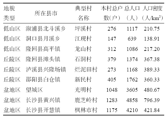 |
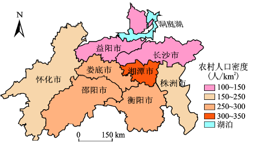
1) 聚落规模与密度。由图2与表1可知,江南丘陵湖南地区的农村人口密度存在着较大的地域差异,总体上呈现出由中心向东西两翼递减的态势。湘潭市、娄底市、衡阳市的农村人口密度较高,怀化市的农村人口密度最低,而株洲市和长沙市由于城镇化水平高,农村人口数量少,农村人口密度也相对较低。其中湘潭市农村人口密度最高,为309.15人/km2,而怀化市农村人口密度最低,仅为101.81人/km2。从18个典型抽样村的数据可以看出,不同地貌类型区乡村聚落的平均规模、农村人口密度等存在较大差异,呈现出较为明显的盆地-丘陵-低山区的地貌梯度分异规律,乡村聚落的低海拔指向性特征较为明显[20]。
图2 2015年江南丘陵湖南地区农村人口的空间分布
Fig.2 Spatial distribution of rural population in Hunan Province in 2015
2) 聚落形态。在典型抽样村分析的基础上,借助于遥感影像并结合实地调查,发现江南丘陵湖南地区乡村聚落的空间形态呈现出点、线、面相结合的多样化分布特征,与地貌类型分布的吻合度较高,其空间形态呈现为团块型、团簇型、散点型、条带型等。其中团块型主要分布在盆地区,乡村聚落形状较为规整,聚落周边一般都有大面积的农田,乡村基础设施较为完善,边界较为明显,聚落内部的联系较为密切,且聚落内的各项功能用地如居住、生产、生态、交通、公共设施较为明确清晰,如长沙县的武塘村、鹿芝岭村、金江新村、枫林市村及望城区的光明村等。散点型多分布在低山区,聚落的边界较为模糊,内部联系较为松散,聚落内的居住、生产、生态、交通、公共设施等功能用地较为模糊,农户的耕作半径不大,如新晃县的祥冲村、溆浦县的坪溪村、洞口县的江现村、隆回县的龙山村、绥宁县的梅口村等。丘陵区的聚落空间分布多以团簇型和干枝式、弧线式的条带型为主,公路、河流及山脉指向性特征明显,内部构成较为单一,聚落多与耕地、交通相结合,但聚落内的相互联系不足,管线布置不便,如洪江市的裕农村、芷江县的水宽村、溆浦县的白岩头村、新化县的方荣华村、隆回县的石洞村、泸溪县的烂泥田村、邵阳县的新民村、茶陵县的狮江村等。江南丘陵湖南地区的聚落形态呈现出较为明显的地貌梯度分异规律。
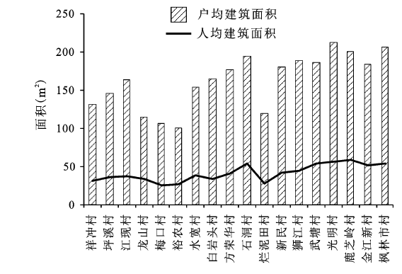
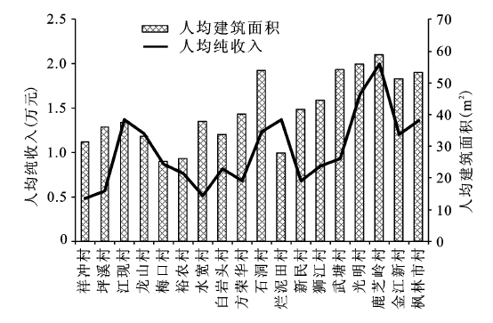
1) 住房面积。江南丘陵湖南地区18个抽样村的户均及人均住宅建筑面积总体上呈现出“西低东高,南低北高”的地域分异特征(图3,图4)。其中农村居民户均住宅建筑面积为162.72 m2,裕农村、梅口村、龙山村、烂泥田村、祥冲村、坪溪村、水宽村7个村的户均住宅建筑面积低于区域平均水平,光明村、枫林市村、鹿芝岭村的户均住宅建筑面积超过了200 m2。农村人均住宅建筑面积的地域分异则呈现出与经济发展、农民收入水平一致的梯度规律[21],50~55 m2主要是在盆地区和丘陵区的近郊村,其经济发展及农民收入水平高,即长沙市区的5个村和隆回的石洞村,40~50 m2主要是在丘陵区的近郊村,如狮江村、新民村和方荣华村,30 m2以下的主要分布在山区和丘陵的远郊和偏远村,如烂泥田村、裕农村和梅口村。江南丘陵湖南地区乡村聚落的住房面积呈现出较为明显的发达-欠发达-落后的经济梯度差异。
图3 2015年江南丘陵湖南地区18个抽样村人均与户均住房建筑面积
Fig.3 Housing area of per capita and per household of 18 sample survey villages in Hunan Province in 2015
图4 2015年江南丘陵湖南地区18个抽样村人均住宅建筑面积与人均纯收入
Fig.4 Per capita residential building area and per capita net income of 18 sample survey villages in Hunan Province in 2015
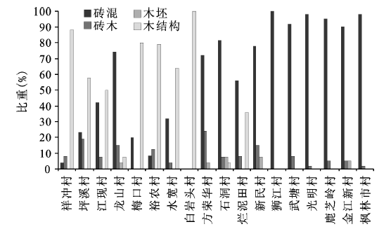
2) 住房结构。房屋建造多追求经久耐用,在建筑材料选用上多是利用本地所产材料,用最为经济的方式并结合当地气候和地形等自然条件来进行建造。从图5与图6可知,江南丘陵湖南地区18个抽样村农村住宅结构主要包括了砖混、砖木、木坯和木结构4种,但各地区的住房结构存在很大的差异。湘西多山,盛产木材,因此农村住宅建设中木结构最为普遍,祥冲村、龙山村、梅口村、白岩头村的抽样农户中近80%的农户住宅均为木结构,尤其是白岩头村达到了100%,而湘东及湘中地区由于经济较为发达,砖混、砖木结构较为普遍,武塘村、光明村、鹿芝岭村、枫林市村抽样调研农户的住宅均为砖混与砖木结构。从建造时间看,20世纪90年代以后建造的住宅占总住宅比例的近70%,但是各地区仍存在较大差异,祥冲村、坪溪村、梅口村、裕农村、白岩头村在20世纪90年代以前建造的住宅占总住宅比例的50%以上,而光明村、鹿芝岭村90%以上的住宅为2000年以后修建。抽样村的住宅建筑结构、建造时间与区域农村经济发展水平、农民收入水平呈现较大的相关性,也即住房结构的经济梯度差异较为明显。
图5 2015年江南丘陵湖南地区18个抽样村农村住宅结构
Fig.5 Rural residential structure of 18 sample survey villages in Hunan Province in 2015
图6 2015年江南丘陵湖南地区18个抽样村农村住宅建造时间
Fig.6 Construction time of rural houses of 18 sample survey villages in Hunan Province in 2015
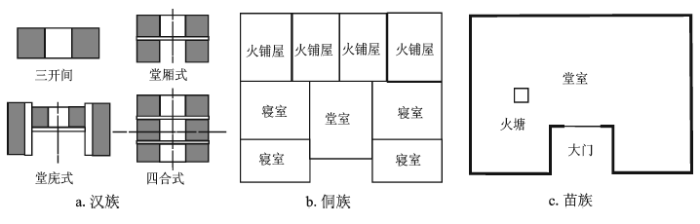
3) 建筑风格。江南丘陵湖南地区的民族构成较为复杂,各民族由于历史、文化的差异及其自身特有的地理条件,从而形成了汉族、侗族、苗族等具有鲜明特征的地方建筑风格[22](图7)。汉族民居主要分布在湘东和湘中地区的长沙县等地,由于汉族人口数量多、分布广,乡村居民的建筑类型较为多样,其中最具代表的要数湘赣民系,这类民居建筑发展较为成熟,在平面布局上以天井与堂屋为核心,并在“一明两暗”的空间布局基础上发展成为“天井堂庑”、“天井堂厢”、“四合天井”和“中庭”型,功能类型多样,强调民居的平面轴对称,重点突出堂屋的地位与作用,外墙上的门窗数量较少;侗族民居主要分布湘西怀化的新晃和芷江等地,这些地区的气候环境较为恶劣,侗族民居大多是依山而建,傍水而筑,以山水为本,形成美丽的村寨,侗族民居以穿斗式的干阑式建筑居多,一般分为上下两层,第一层主要是堂屋、卧室、火铺屋、厨房等功能用房,第二层则主要作为杂物间等附属用房,一般没有墙壁围护。侗族民居在构成与功能上最具特征的是火铺,又叫火床,是架于地面之上的一个木板台面,中间置一火塘,集聚了厨房、餐厅和温室等多种功能。平面布置多以堂屋为中心,两侧布置卧室,沿进深向火铺屋和堂屋集中布置,因火铺屋和堂屋的尺寸要求很大,所以平面往纵深发展,进深大;苗族民居主要分布在湘西土家苗族自治州的泸溪、邵阳的绥宁等偏远山区,建筑布局受地形条件的限制很大,民居因山就势,多聚族而居,形成聚落,少则数户,多则数十户、上百户,具有浓郁的苗族特色。苗居多在房屋一端或两端设置吊脚楼与主屋相接,主屋通常为两到三开间,自左至右依次包括了居室、堂屋、厨厕。堂屋前部退入二三步,形成凹廊,堂屋前装桶门两、四或六扇,可拆卸,厨房设灶台,后半部作畜栏厕所,屋内较少隔断,开敞灵活,以适应其吃牛和接龙等祭祀、庆典歌乐活动的需要。乡村聚落的建筑风格与地貌类型、民族等呈现出较强的相关性。
图7 江南丘陵湖南地区汉族、侗族、苗族民居示意图
Fig.7 Residential sketch map of Han, Dong, Miao in Hunan Province
4) 住房满意度。从图8可知,江南丘陵湖南地区18个抽样村农户对住房满意、较满意及不满意的比例分别为66.44%、22.77%和10.79%。其中光明村、鹿芝岭村的满意度最高,而裕农村的满意度最低。农户对住房的满意程度与其家庭人均住房面积、住房结构和住房质量有一定的关系。光明村、鹿芝岭村的住房多以砖混结构为主,建造时间较短,住房条件与其他村相比较为优越,农户满意度较高,而裕农村的住房多以木结构为主,修建年代久远,漏雨及倒塌危险比例高,故农户的满意度偏低。因此,住房满意程度与住房质量、乡村区域经济发展水平呈现出较强的相关性。
图8 2015年江南丘陵湖南地区18个抽样村住房满意度
Fig.8 Satisfaction of housing of 18 sample villages in Hunan Province in 2015
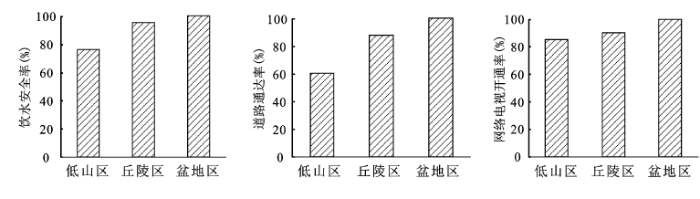
乡村聚落的水、电、路、网等基础设施及幼儿园、学校、医院、文体中心等公共配套设施是农村居民生活品质与居住质量提升的重要保障。基于数据的可获得性,本研究选取抽样村的饮水安全达标率、规模25户以上自然村寨通达率、网络电视开通率等指标反映乡村聚落的居住设施水平高低,通过实地调研所获得的数据发现,江南丘陵湖南地区18个抽样村乡村聚落的居住设施地域差异较为明显,整体呈现出“西低东高,山区低盆地高”的格局(图9)。聚落的居住设施呈现出较为显著的盆地-丘陵-低山区地貌分异规律。
图9 2015年江南丘陵湖南地区不同地貌类型区的饮水安全率、道路通达率、网络电视开通率
Fig.9 Rate of drinking water safety, road access and network TV opening in different types of landforms in Hunan Province in 2015
近年来随着城乡不断融合,乡村地区的传统生产、生活方式开始向多元化态势转变,不同地区由于区位条件差异,其乡村居民的生产生活形态也差异显著,呈现出较为显著的近郊-远郊-偏远区位梯度差异,主要有以下3种类型。
1) 发达的近郊区型。这类乡村聚落离中心城市的距离较近,区位条件优越,农户生计多元化发展,农户兼业、县域内、县域外就业特征明显,农村生产生活方式向非农化、城镇化、现代化及多元化迅速转型。如望城区的光明村,该村属于长沙市大河西先导区,利用其独有的自然山水特色和交通区位优势,将现代农业与乡村旅游业有机结合起来,打造“具有湖湘特色,集休闲、度假村、观光于一体的生态农庄第一品牌”,促进乡村功能由单一的居住、农业生产功能向居住生活、生态环保、休闲观光、旅游体验、种养经营一体化的多种复合功能转变,农民的兼业化程度高,生活较为方便舒适,期待值高,城乡互动密切。
2) 欠发达的远郊区型。这类村庄离城镇的距离较远,农民以劳务输出和传统农业作为主要生产形式,生活方式模仿和学习城镇,部分农户开始出现县域非农兼业行为,农户流动规模不大且具有被动性。传统生产生活方式受现代化与城镇化的剧烈冲击而面临即将解体,但现代生产生活方式尚缺乏相应的产业支撑。如邵阳县的新民村,该村农户的经济方式主要是靠务农和到县域务工,其生活方式受城镇的影响与冲击较大,但仍以血缘、姻缘、宗族关系为主,村域内农户邻里关系密切。
3) 落后的偏远区型。这类村庄多处于地形复杂、交通条件相对落后且与城镇的距离偏远的地域,通常以传统农业为主,但在一些历史较为悠久、传统文化底蕴较为深厚且具有旅游开发价值的传统村落,开始出现传统农业、旅游和商贸服务相结合的产业形态,由于远离城镇,部分农户开始出现县域和县域外非农就业。如新化县的方荣华村,距县城64 km2,仍停留在传统农业发展阶段,维持自给自足的小农经济状态,农业技术较为落后,土地产出效益低下,在生活形态方面,村民对传统习俗、公共空间、集体活动非常注重,生活质量虽低但是较安逸,且期望值不高,村庄认同与安全感较强,生活较为闲散,邻里关系密切。
1) 聚落空间格局、居住条件、居住设施和生产生活形态是反映乡村聚落地域分异特征的4个核心要素。江南丘陵地区地域范围广泛,区域内的资源禀赋、经济发展基础、文化传统差异悬殊,决定了江南丘陵地区乡村聚落空间布局具有较强的复杂性及特殊性。湖南省是江南丘陵地区的主体,以该地域为研究对象,能够反映江南丘陵地区乡村聚落的总体发展规律。
2) 江南丘陵湖南地区的农村人口密度总体上呈现出由中心向东西两翼递减的态势,乡村聚落的空间形态呈现出团块型、团簇型、散点型、条带型等多样化分布特征。不同地貌类型区乡村聚落的平均规模、农村人口密度等存在较大差异。而乡村聚落的居住设施整体呈现出“西低东高,山区低盆地高”的格局。总体而言,乡村聚落发展在空间格局和居住设施上均呈现出较为明显的盆地-丘陵-低山区的地貌梯度分异规律。
3) 江南丘陵湖南地区抽样村户均及人均住宅建筑面积呈现出“西低东高,南低北高”的地域分异特征。在农村住宅结构上主要包括了砖混、砖木、木坯和木结构。建筑风格上呈现出鲜明特征的汉族、侗族、苗族风格。不同地区居民住房满意程度与住房质量、区域经济发展水平相关性较强。因此,乡村聚落的居住条件呈现出较为明显的发达-欠发达-落后的经济梯度差异。
乡村聚落研究是江南丘陵地区乡村聚落空间布局优化与调控的基础。但是由于资料收集的困难性,本研究在典型样点村选择时,仅以江南丘陵地区的主体区域——湖南省为案例区,而没有从江南丘陵地区其他4个省选取典型村来进行系统研究,同时本研究仅采用江南丘陵地区2015年的相关数据对其乡村聚落发展进行静态研究,而没有采用不同时段数据分析其动态变化的过程,因此研究结果可能不能全面把握其发展特征,对区域乡村聚落发展的指导作用也会受到一定的限制。
The authors have declared that no competing interests exist.
| [1] |
长沙市农村居民点景观格局变化及地域分异特征研究 [J].
<p>以1989年、1999年和2009年3期Landsat TM影像及2005年的土地利用现状图为数据源,结合野外实地调查,应用GIS 空间分析、重心迁移定量模型和景观生态学方法,对长沙市1989~2009 年农村居民点的用地面积、规模、空间分布、形状的动态变化过程及地域分异特征进行了研究.研究结果表明: ① 20 a 来农村居民点总面积及斑块平均规模不断扩大,农村居民点空间分布日趋集中和密集,斑块形状不断向完整与规则转变;② 农村居民点空间布局地域分异特征明显,在平均斑块面积、斑块密度等指标方面平原区、丘岗区与山区之间存在着显著差异;③ 20 a来,长沙市农村居民点的空间分布重心由西向东迁移,迁移距离为6.62 km.</p>
Landscape pattern changes and the characteristic of spatio-temporal differentiation of rural residential area in Changsha in recent 20 years .
<p>以1989年、1999年和2009年3期Landsat TM影像及2005年的土地利用现状图为数据源,结合野外实地调查,应用GIS 空间分析、重心迁移定量模型和景观生态学方法,对长沙市1989~2009 年农村居民点的用地面积、规模、空间分布、形状的动态变化过程及地域分异特征进行了研究.研究结果表明: ① 20 a 来农村居民点总面积及斑块平均规模不断扩大,农村居民点空间分布日趋集中和密集,斑块形状不断向完整与规则转变;② 农村居民点空间布局地域分异特征明显,在平均斑块面积、斑块密度等指标方面平原区、丘岗区与山区之间存在着显著差异;③ 20 a来,长沙市农村居民点的空间分布重心由西向东迁移,迁移距离为6.62 km.</p>
|
| [2] |
平原水乡乡村聚落空间分布规律与格局优化——以湖北公安县为例 [J].The spatial distribution and pattern optimization of rural settlements in plain water area: a case of Gong′an, Hubei . |
| [3] |
Determinants of residential land-use conversion and sprawl at the rural-urban fringe [J].https://doi.org/10.1111/j.0002-9092.2004.00641.x URL [本文引用: 1] 摘要
We estimate a probit model of residential land conversion using parcel-level data from a rural-urban county in Ohio. Spatial landscape pattern metrics are used to quantify land-use patterns and to link patterns of residential sprawl with factors estimated to influence parcel-level land conversion. Findings indicate that the location of new residential development is influenced by preferences for lower density areas that nonetheless are close to existing urban development. Combined, these forces have generated a moderated pattern of residential sprawl. Spatial error autocorrelation is controlled using a spatial sampling technique that enables consistent estimation of the probit model.
|
| [4] |
论土地整治与乡村空间重构 [J].Land consolidation and rural spatial restructuring . |
| [5] |
基于生活质量导向的乡村聚落空间优化研究 [J].https://doi.org/10.11821/dlxb201410006 URL [本文引用: 1] 摘要
引入"生活质量理论",基于乡村聚落空间与生活质量的双向循环互动机理,从乡村聚落空间功能整合、空间结构优化、空间尺度调控等三个方面研究乡村聚落空间优化问题,试图构建有效提高生活质量的乡村聚落空间优化框架与模式。研究认为:1聚落是生活质量的空间载体,生活质量是聚落的本质内容,乡村聚落与生活质量相互促进、相互影响,构建科学合理的乡村聚落空间是提高农民生活质量的重要前提。2乡村聚落空间功能类型可以划分为生计维持型功能、产业发展型功能与品质提升型功能,生活质量导向的乡村聚落空间功能优化,重点在于提升生计维持型功能,整合产业发展型功能,植入品质提升型功能。3乡村聚落空间结构优化的重点有两个方面,一是要促进居住空间、农业空间、工业空间有机集聚,社会交往空间、休闲空间、服务空间有机疏散,生活空间、生产空间、生态空间有机均衡,以实现聚落内部空间类型比例合理化与组合最优化;二是要通过聚居区位转换与聚落职能调整,移拆部分衰落村落,保留部分一般村落,扩大部分重点村落,新建部分新型村落,形成"综合村—特色村"的功能结构等级,构建以乡村公路为链接的聚落体系空间组织模式。4 RROD模式是基于生活质量导向的乡村聚落空间优化的理想模式,该模式的构建要合理确定聚落单体的规模尺度与聚落之间的距离尺度,引导形成结构合理、设施配套、功能完备、分布有序的RROD和RROD体系。
The research on optimization mode of spatial organization of rural settlements oriented by life quality .https://doi.org/10.11821/dlxb201410006 URL [本文引用: 1] 摘要
引入"生活质量理论",基于乡村聚落空间与生活质量的双向循环互动机理,从乡村聚落空间功能整合、空间结构优化、空间尺度调控等三个方面研究乡村聚落空间优化问题,试图构建有效提高生活质量的乡村聚落空间优化框架与模式。研究认为:1聚落是生活质量的空间载体,生活质量是聚落的本质内容,乡村聚落与生活质量相互促进、相互影响,构建科学合理的乡村聚落空间是提高农民生活质量的重要前提。2乡村聚落空间功能类型可以划分为生计维持型功能、产业发展型功能与品质提升型功能,生活质量导向的乡村聚落空间功能优化,重点在于提升生计维持型功能,整合产业发展型功能,植入品质提升型功能。3乡村聚落空间结构优化的重点有两个方面,一是要促进居住空间、农业空间、工业空间有机集聚,社会交往空间、休闲空间、服务空间有机疏散,生活空间、生产空间、生态空间有机均衡,以实现聚落内部空间类型比例合理化与组合最优化;二是要通过聚居区位转换与聚落职能调整,移拆部分衰落村落,保留部分一般村落,扩大部分重点村落,新建部分新型村落,形成"综合村—特色村"的功能结构等级,构建以乡村公路为链接的聚落体系空间组织模式。4 RROD模式是基于生活质量导向的乡村聚落空间优化的理想模式,该模式的构建要合理确定聚落单体的规模尺度与聚落之间的距离尺度,引导形成结构合理、设施配套、功能完备、分布有序的RROD和RROD体系。
|
| [6] |
基于共生理论的村域尺度下农村居民点空间重构策略与实现 [J].https://doi.org/10.3969/j.issn.1002-6819.2014.03.027 URL Magsci [本文引用: 1] 摘要
农村居民点利用低效化是城乡转型进程中乡村地域系统演化的一种不良过程,对其进行空间重构成为合理利用土地资源、扎实推进新农村建设、重构乡村空间、促进城乡一体化发展的突破口。该研究引入共生理论,通过分析农村居民点空间重构共生系统,明确重构原则与步骤,构建农村居民点空间重构策略,对整村推进示范村重庆市合川区大柱村予以实证,构筑了生产功能型、服务功能型、生活功能型3种农村居民点组团并在村域尺度下予以空间表达,形成"一轴一带三团"的村域空间布局。结果表明,共生理论对于农村居民点空间重构具有较强的适用性;基于共生策略的农村居民点空间重构既能确保农村居民点的互联互通,又能尊重农户主体地位,实现村域"资源共享、环境共建",发挥村域资源优势,提高农村居民点利用效率,为丘陵山区整村推进与美丽乡村建设提供一种新思路。
Rural settlement space reconstruction strategy and implementation based on symbiosis theory on village scale .https://doi.org/10.3969/j.issn.1002-6819.2014.03.027 URL Magsci [本文引用: 1] 摘要
农村居民点利用低效化是城乡转型进程中乡村地域系统演化的一种不良过程,对其进行空间重构成为合理利用土地资源、扎实推进新农村建设、重构乡村空间、促进城乡一体化发展的突破口。该研究引入共生理论,通过分析农村居民点空间重构共生系统,明确重构原则与步骤,构建农村居民点空间重构策略,对整村推进示范村重庆市合川区大柱村予以实证,构筑了生产功能型、服务功能型、生活功能型3种农村居民点组团并在村域尺度下予以空间表达,形成"一轴一带三团"的村域空间布局。结果表明,共生理论对于农村居民点空间重构具有较强的适用性;基于共生策略的农村居民点空间重构既能确保农村居民点的互联互通,又能尊重农户主体地位,实现村域"资源共享、环境共建",发挥村域资源优势,提高农村居民点利用效率,为丘陵山区整村推进与美丽乡村建设提供一种新思路。
|
| [7] |
Population distribution, settment patterns and accessibility across Africa in 2010 [J]. |
| [8] |
Spatial patterns of rural and exurban residential settlement and agricultural trends in the Intermountain West[D] . |
| [9] |
苏北地区乡村聚落的空间格局 [J].https://doi.org/10.11821/yj2012010014 URL [本文引用: 1] 摘要
基于苏北地区2008年卫星遥感影像,通过运用空间插值、空间关联指数、空间变差函数等空间测度模型,深入分析了苏北地区乡村聚落的空间格局特征。结果表明:在空间分布上,苏北地区乡村聚落具有“南密北疏”的特征;在规模分布上,苏北地区乡村聚落表现出很强的空间自相关性,并出现高值簇的空间集聚,其主要集中于徐州、连云港和宿迁等地,总体上呈现“南低北高”的空间分布特征;在形态分布上,苏北地区乡村聚落形态的空间分布格局具有较好的连续性和稳定性。空间分异格局中的随机成份较低,而由空间自相关引起的结构化分异则较为显著。从不同方向来看,苏北地区乡村聚落形态分布表现出一定的各向异性,其中东南一西北方向的乡村聚落形态呈现出明显的阶梯状分布特征,自东南向西北,聚落形态具体表现为由带状、长矩形、矩形到方形或不规则团块状的渐进性演变。总体来看,苏北地区乡村聚落的空间格局具有明显的空间依赖性。
Analysis of spatial pattern of rural settlements in northern Jiangsu .https://doi.org/10.11821/yj2012010014 URL [本文引用: 1] 摘要
基于苏北地区2008年卫星遥感影像,通过运用空间插值、空间关联指数、空间变差函数等空间测度模型,深入分析了苏北地区乡村聚落的空间格局特征。结果表明:在空间分布上,苏北地区乡村聚落具有“南密北疏”的特征;在规模分布上,苏北地区乡村聚落表现出很强的空间自相关性,并出现高值簇的空间集聚,其主要集中于徐州、连云港和宿迁等地,总体上呈现“南低北高”的空间分布特征;在形态分布上,苏北地区乡村聚落形态的空间分布格局具有较好的连续性和稳定性。空间分异格局中的随机成份较低,而由空间自相关引起的结构化分异则较为显著。从不同方向来看,苏北地区乡村聚落形态分布表现出一定的各向异性,其中东南一西北方向的乡村聚落形态呈现出明显的阶梯状分布特征,自东南向西北,聚落形态具体表现为由带状、长矩形、矩形到方形或不规则团块状的渐进性演变。总体来看,苏北地区乡村聚落的空间格局具有明显的空间依赖性。
|
| [10] |
苏中地区乡村聚落的格局特征分析及类型划分 [J].https://doi.org/10.1007/s11783-011-0280-z URL Magsci [本文引用: 1] 摘要
Based on fused images of both SPOT and TM in 2008 in central Jiangsu Province as the major data sources, the delineation, water, roads, and other spatial information of rural settlements in the research area are achieved via man-machine interactive interpretation. By the spatial analysis and cluster analysis techniques, grids as the cells, the distribution patterns of rural settlements in central Jiangsu are analyzed, and the categories of rural settlements are classified. The results indicate that: (1) The density of rural settlements in the research area is high in the east and west, lower in the center. However, land-use scale in settlements presents an opposite pattern. (2) The rural settlements that have a high complexity in shape and high degree of fragmentation are located in the south of Taizhou area and in Nantong coastal areas. However, the complexity and fragmentation in the south-central region of Yangzhou, north Taizhou, central, west and south Nantong rural settlements are very small. (3) The differentiation characteristic of the mean nearest neighbor distance is that the rural settlements have a longer distance in the middle of research area, which it indicates that the settlement distribution is sparser and more scattered, the distance of the settlements in the south and east is more nearer, and the distribution of settlements is very concentrated. The distance of the mean nearest neighbor water of the settlements in Nantong area is very small in the southeast settlements, large in the west. The distance of the mean nearest neighbor water of the settlements in Yangzhou area is very small in the west, large in the east. The average spatial distribution pattern of the mean nearest neighbor road of the settlements is unapparent. But the average distance of the most settlements from the roads is very small, from which it indicates that it is very convenient for the settlement in the areas to have internal and external contacts. (4) Finally, by means of establishing the measurement index system of the rural settlements, adopting the method of hierarchical cluster, and combining with the patterns of rural settlements, the rural settlements of central Jiangsu province are divided into three types: Lixiahe lake type, bottomlands along Yangtze River and Yellow Sea type, and central Jiangsu plain type. Lixiahe lake type is low-density cluster-like. Bottomlands along Yangtze River and Yellow Sea type can be divided into two sub-types, such as medium-density arc-belt type and high-density stripe type. Central Jiangsu plain can be divided into 3 sub-types, such as low-density mass type, medium-density broad-band type, and high-density point-scattered type.
Distribution patterns characteristics and type classification of the rural settlements in Central Jiangsu Province .https://doi.org/10.1007/s11783-011-0280-z URL Magsci [本文引用: 1] 摘要
Based on fused images of both SPOT and TM in 2008 in central Jiangsu Province as the major data sources, the delineation, water, roads, and other spatial information of rural settlements in the research area are achieved via man-machine interactive interpretation. By the spatial analysis and cluster analysis techniques, grids as the cells, the distribution patterns of rural settlements in central Jiangsu are analyzed, and the categories of rural settlements are classified. The results indicate that: (1) The density of rural settlements in the research area is high in the east and west, lower in the center. However, land-use scale in settlements presents an opposite pattern. (2) The rural settlements that have a high complexity in shape and high degree of fragmentation are located in the south of Taizhou area and in Nantong coastal areas. However, the complexity and fragmentation in the south-central region of Yangzhou, north Taizhou, central, west and south Nantong rural settlements are very small. (3) The differentiation characteristic of the mean nearest neighbor distance is that the rural settlements have a longer distance in the middle of research area, which it indicates that the settlement distribution is sparser and more scattered, the distance of the settlements in the south and east is more nearer, and the distribution of settlements is very concentrated. The distance of the mean nearest neighbor water of the settlements in Nantong area is very small in the southeast settlements, large in the west. The distance of the mean nearest neighbor water of the settlements in Yangzhou area is very small in the west, large in the east. The average spatial distribution pattern of the mean nearest neighbor road of the settlements is unapparent. But the average distance of the most settlements from the roads is very small, from which it indicates that it is very convenient for the settlement in the areas to have internal and external contacts. (4) Finally, by means of establishing the measurement index system of the rural settlements, adopting the method of hierarchical cluster, and combining with the patterns of rural settlements, the rural settlements of central Jiangsu province are divided into three types: Lixiahe lake type, bottomlands along Yangtze River and Yellow Sea type, and central Jiangsu plain type. Lixiahe lake type is low-density cluster-like. Bottomlands along Yangtze River and Yellow Sea type can be divided into two sub-types, such as medium-density arc-belt type and high-density stripe type. Central Jiangsu plain can be divided into 3 sub-types, such as low-density mass type, medium-density broad-band type, and high-density point-scattered type.
|
| [11] |
镇江市丘陵区乡村聚落空间格局特征及其影响因素分析 [J].https://doi.org/10.3969/j.issn.1008-1070.2014.08.004 URL Magsci [本文引用: 1] 摘要
Rural settlements are the places of habitation, production and the living for people.In this paper,through landscape pattern analysis and GIS spatial analysis methods,the spatial pattern characteristics and influencing factors of rural settlements in Zhenjiang of Jiangsu Province were analyzed.Some conclusions are drawn as follows.Spatial pattern of rural settlements in Zhenjiang showed an eastest differentiation.In the east region of Zhenjiang,rural settlements pattern presented the characteristic of small scale,dense distribution and regular morphology.Meanwhile, in the west region of Zhenjiang,rural settlements pattern presented the characteristic of large scale,sparse distribution and broken morphology.Influencing factors of rural settlements spatial pattern included terrain,economic,traffic,water system,and the distance of cultivated land.Through the analysis,settlement distribution had low altitude location orientation.Rural settlements plaques area of economic developed region was small,plaques density was large, but in the undeveloped region,rural settlements plaques area was great, plaques density was small.Rural settlements spatial distribution was most densely populated in the area away road at a distance of 500 meters and away water system at a distance of 1 000 meters.Rural settlements and cultivated lands spatial distribution had significant convergence. Currently,rural geography was a weak branch of human geography,especially with regard to theoretical development and the empirical research.This paper took Zhenjiang for example,analyzed spatial pattern and influencing factors of rural settlements,which not only could enrich rural settlement geography theory research, but also could provide the reference of rural settlements planning in Zhenjiang hilly area.
Spatial pattern and influencing factors of rural settlements in Zhenjiang hilly area .https://doi.org/10.3969/j.issn.1008-1070.2014.08.004 URL Magsci [本文引用: 1] 摘要
Rural settlements are the places of habitation, production and the living for people.In this paper,through landscape pattern analysis and GIS spatial analysis methods,the spatial pattern characteristics and influencing factors of rural settlements in Zhenjiang of Jiangsu Province were analyzed.Some conclusions are drawn as follows.Spatial pattern of rural settlements in Zhenjiang showed an eastest differentiation.In the east region of Zhenjiang,rural settlements pattern presented the characteristic of small scale,dense distribution and regular morphology.Meanwhile, in the west region of Zhenjiang,rural settlements pattern presented the characteristic of large scale,sparse distribution and broken morphology.Influencing factors of rural settlements spatial pattern included terrain,economic,traffic,water system,and the distance of cultivated land.Through the analysis,settlement distribution had low altitude location orientation.Rural settlements plaques area of economic developed region was small,plaques density was large, but in the undeveloped region,rural settlements plaques area was great, plaques density was small.Rural settlements spatial distribution was most densely populated in the area away road at a distance of 500 meters and away water system at a distance of 1 000 meters.Rural settlements and cultivated lands spatial distribution had significant convergence. Currently,rural geography was a weak branch of human geography,especially with regard to theoretical development and the empirical research.This paper took Zhenjiang for example,analyzed spatial pattern and influencing factors of rural settlements,which not only could enrich rural settlement geography theory research, but also could provide the reference of rural settlements planning in Zhenjiang hilly area.
|
| [12] |
苏北地区乡村聚落的空间格局及其影响因子分析 [J].https://doi.org/10.13872/j.1000-0275.2014.0007 URL [本文引用: 1] 摘要
基于苏北地区2007/2008年的SPOT卫星影像,运用空间韵律测度、核密度分布估计、标准差椭圆、最近邻距离指数、空间邻近度等模型,定量分析苏北地区乡村聚落的空间格局特征并探讨聚落的影响因子。结果表明,苏北地区乡村聚落空间分布存在明显的地域分异格局。淮安盐城地区聚落呈现小而集聚型分布,徐州宿迁连云港地区聚落呈现大而稀疏型分布。聚落分布与地貌、水系、交通等因素具有高度相关性。河流泛滥平原聚落分布不规则,山前冲积平原聚落具有较好的连续性,黄土岗地聚落分布破碎化程度较高。盐城、淮安部分地区聚落平均最邻近水系距离较小,有利于农村居民的生产生活。徐州、连云港、宿迁地区聚落平均最邻近道路距离较小,对内对外交通联系便利。最后文章探讨苏北地区乡村聚落的发展及合理布局的措施。
The spatial pattern of rural settlements and influencing factors in Northern Jiangsu area .https://doi.org/10.13872/j.1000-0275.2014.0007 URL [本文引用: 1] 摘要
基于苏北地区2007/2008年的SPOT卫星影像,运用空间韵律测度、核密度分布估计、标准差椭圆、最近邻距离指数、空间邻近度等模型,定量分析苏北地区乡村聚落的空间格局特征并探讨聚落的影响因子。结果表明,苏北地区乡村聚落空间分布存在明显的地域分异格局。淮安盐城地区聚落呈现小而集聚型分布,徐州宿迁连云港地区聚落呈现大而稀疏型分布。聚落分布与地貌、水系、交通等因素具有高度相关性。河流泛滥平原聚落分布不规则,山前冲积平原聚落具有较好的连续性,黄土岗地聚落分布破碎化程度较高。盐城、淮安部分地区聚落平均最邻近水系距离较小,有利于农村居民的生产生活。徐州、连云港、宿迁地区聚落平均最邻近道路距离较小,对内对外交通联系便利。最后文章探讨苏北地区乡村聚落的发展及合理布局的措施。
|
| [13] |
中国农村居民点布局优化研究综述 [J].Review of research on layout optimization of rural settlements in China. China Population, |
| [14] |
|
| [15] |
江南红黄壤丘陵区土壤湿度模拟和季节性干旱的研究 [J].
根据江南红黄壤丘陵区17个站点1951~1988年逐旬气象资料以及相应地区的土壤物理参数,模拟出各站点土壤层的土壤湿度数据库,并分析土壤季节性干旱规律。其中衡阳、邵阳地区是江南红黄壤丘陵区土壤季节性干旱最严重的地区,其次是南昌、贵溪市一带。通常年份,2月中旬~6月下旬,全区几乎不出现土壤季节性干旱。土壤季节性干旱主要出现在7月下旬到10月下旬,其机率在50%以上,8月上、中旬,9月中~10月中旬出现的机率为60%。江南红黄壤丘陵区夏季干旱往往连着秋季干旱。这种连旱的机率衡阳地区在60%以上。冬季1~2月的土壤季节性干旱应是第一年秋旱的延续。文中也提出江南红黄壤丘陵区土壤季节性干旱的防御措施。
Simulation of soil moisture and study on seasonal soil drought in the red-yellow soil zone South of Yangtze River .
根据江南红黄壤丘陵区17个站点1951~1988年逐旬气象资料以及相应地区的土壤物理参数,模拟出各站点土壤层的土壤湿度数据库,并分析土壤季节性干旱规律。其中衡阳、邵阳地区是江南红黄壤丘陵区土壤季节性干旱最严重的地区,其次是南昌、贵溪市一带。通常年份,2月中旬~6月下旬,全区几乎不出现土壤季节性干旱。土壤季节性干旱主要出现在7月下旬到10月下旬,其机率在50%以上,8月上、中旬,9月中~10月中旬出现的机率为60%。江南红黄壤丘陵区夏季干旱往往连着秋季干旱。这种连旱的机率衡阳地区在60%以上。冬季1~2月的土壤季节性干旱应是第一年秋旱的延续。文中也提出江南红黄壤丘陵区土壤季节性干旱的防御措施。
|
| [16] |
农村居民点重构治理路径模式的研究 [J].https://doi.org/10.3969/j.issn.1002-6819.2014.03.028 URL Magsci [本文引用: 1] 摘要
为补充并丰富国内对农村居民点重构治理路径模型的理论研究,针对不同重构模式探索治理路径的选择方向,提升农村居民点重构治理的实践绩效,该研究1)比较分析了不同农村居民点重构的差异特点,区分识别了当前农村居民点重构的3种典型模式:"拆迁型"、"建设型"和"保留型";2)在简要回顾2个经典理论的基础上,构建了全新的治理路径分析框架:"光谱-阶梯治理路径";3)针对不同重构模式选择了广西省柳州市3个典型案例对治理路径及绩效优劣进行比较研究。研究发现不同重构模式相对适宜于特定混合型重构治理路径,治理路径的选择应考虑主客观状况的匹配程度,充分体现政府、市场和民众的公共资源多中心治理。在当前中国的现实条件下,只有注重政府推动、市场配置与农户构想的有机统一,并在治理路径中额外加强政策支持、引导和监管,才能确保农民作为重构活动的主体地位,切实促进农村居民点重构的治理效果最优,充分实现土地利用的规模化和集约化。
Research on governance path of rural settlements reconstruction patterns .https://doi.org/10.3969/j.issn.1002-6819.2014.03.028 URL Magsci [本文引用: 1] 摘要
为补充并丰富国内对农村居民点重构治理路径模型的理论研究,针对不同重构模式探索治理路径的选择方向,提升农村居民点重构治理的实践绩效,该研究1)比较分析了不同农村居民点重构的差异特点,区分识别了当前农村居民点重构的3种典型模式:"拆迁型"、"建设型"和"保留型";2)在简要回顾2个经典理论的基础上,构建了全新的治理路径分析框架:"光谱-阶梯治理路径";3)针对不同重构模式选择了广西省柳州市3个典型案例对治理路径及绩效优劣进行比较研究。研究发现不同重构模式相对适宜于特定混合型重构治理路径,治理路径的选择应考虑主客观状况的匹配程度,充分体现政府、市场和民众的公共资源多中心治理。在当前中国的现实条件下,只有注重政府推动、市场配置与农户构想的有机统一,并在治理路径中额外加强政策支持、引导和监管,才能确保农民作为重构活动的主体地位,切实促进农村居民点重构的治理效果最优,充分实现土地利用的规模化和集约化。
|
| [17] |
快速城市化区域农村空心化测度与影响因素研究——以长株潭地区为例 [J].https://doi.org/10.11821/dlyj201704007 URL [本文引用: 1] 摘要
以长株潭地区23个县市区为研究区,从土地、人口、经济三方面构建农村空心化的测度框架及指标体系,综合运用熵值法、多指标综合评价法和多元回归分析等方法对农村空心化进行测度,揭示农村空心化的空间地域分异特征及形成机理。结果表明:①长株潭地区土地空心化呈现由中心城市向外围逐渐减小的特征;人口空心化呈现出中部核心区高,北部低的特征;经济空心化的高、低分布与人口空心化的低、高分布在空间上具有较大的相似性特征。②综合空心化空间分布呈现出不均衡发展的态势,以中、低等级为主,空间分布由中心城市向东西两侧的外围地域逐渐减缓的特征,与中心城市的距离远近对空心化等级的空间分布具有较显著影响。③农村空心化是区域多种因素综合作用的结果,农民收入提高及区域经济发展、农村人口数量及就业结构变化是农村空心化的主导与直接影响因素,土地利用方式及效率的变化在一定程度上抑制了农村空心化程度的加剧。
Assessment and influencing factors of rural hollowing in the rapid urbanization region: A case study of Changsha-Zhuzhou-Xiangtan urban agglomeration .https://doi.org/10.11821/dlyj201704007 URL [本文引用: 1] 摘要
以长株潭地区23个县市区为研究区,从土地、人口、经济三方面构建农村空心化的测度框架及指标体系,综合运用熵值法、多指标综合评价法和多元回归分析等方法对农村空心化进行测度,揭示农村空心化的空间地域分异特征及形成机理。结果表明:①长株潭地区土地空心化呈现由中心城市向外围逐渐减小的特征;人口空心化呈现出中部核心区高,北部低的特征;经济空心化的高、低分布与人口空心化的低、高分布在空间上具有较大的相似性特征。②综合空心化空间分布呈现出不均衡发展的态势,以中、低等级为主,空间分布由中心城市向东西两侧的外围地域逐渐减缓的特征,与中心城市的距离远近对空心化等级的空间分布具有较显著影响。③农村空心化是区域多种因素综合作用的结果,农民收入提高及区域经济发展、农村人口数量及就业结构变化是农村空心化的主导与直接影响因素,土地利用方式及效率的变化在一定程度上抑制了农村空心化程度的加剧。
|
| [18] |
|
| [19] |
山东省沂水县农村非农化程度差异及驱动力 [J].https://doi.org/10.11821/dlxb201506013 URL [本文引用: 1] 摘要
In the rapid process of industrialization and urbanization, non-agriculturalization has become one important tendency of Chinese rural evolution, which at the same time indicates obvious spatial heterogeneity. The participatory rural appraisal is employed, which involves 16 typical villages of Yishui County in Shandong Province, to explore the rural non-agricultural differences and its driving factors. In terms of regional differentiation, the livelihood activities of rural households were divided into four types: non-agricultural employment outside the county, non-agricultural employment inside the county, part-time non-agricultural employment inside the county and agricultural production. Then, we quantified the non-agricultural level by estimating the proportion of rural non-agricultural labor, non-agricultural income and non-agricultural time in 2013. On the basis of this estimation, we discussed the spatial differences and driving forces of rural non-agriculturalization in the study area. The results showed that, (1) Non-agricultural level of the villages was between 37.54% and 90.65%, which indicated that non-agriculturalization was a common phenomenon in traditional agricultural regions. Suburban independent non-agricultural villages developed their own industries, while rural households of other villages were employed in non-agricultural industries outside their villages. It is indicated that the study area was underdeveloped in non-agricultural economy. (2) Suburban villages hold the highest non-agricultural level. Food crops dominated villages showed higher level of non-agriculturalization in the regions near town, while economic crops dominated villages showed lower level of non-agriculturalization. In the same geomorphologic region, food crops dominated villages showed higher level of non-agriculturization than economic crops dominated villages. Spatial differentiation of rural non-agriculturalization was remarkable in traditional agricultural regions at the county scale. (3) As the distances to town became shorter, there was a decline in the proportion of non-agricultural employment outside the county (labor, income, and time), and that inside the county was on the rise, and the proportion of part-time non-agricultural employment inside the county showed an inverted "U"-shaped pattern. (4) The driving mechanism showed that economic diffusing efficiency and the regional accessibility were both deeply influencing employment structure of rural labors, which kept the suburban villages at the highest non-agricultural level. Agricultural income and the demand for labor made non-agricultural level of food crops dominated villages higher than that of economic crops dominated villages. As the distances to town became shorter, owing to economic diffusing efficiency and agricultural income increase, food crops dominated villages showed higher level of non-agriculturalization while economic crops dominated villages showed lower level. Non-agricultural differentiation is an important development trend of traditional agricultural regions in East China. Therefore, the authors suggest that the governments should take concrete measures on rural development management that keep consistent with non-agricultural characteristics and its driving mechanism of different villages.
Rural non-agricultural differences and their driving forces at the county level: A case study of 16 villages in Yishui, Shandong, East China .https://doi.org/10.11821/dlxb201506013 URL [本文引用: 1] 摘要
In the rapid process of industrialization and urbanization, non-agriculturalization has become one important tendency of Chinese rural evolution, which at the same time indicates obvious spatial heterogeneity. The participatory rural appraisal is employed, which involves 16 typical villages of Yishui County in Shandong Province, to explore the rural non-agricultural differences and its driving factors. In terms of regional differentiation, the livelihood activities of rural households were divided into four types: non-agricultural employment outside the county, non-agricultural employment inside the county, part-time non-agricultural employment inside the county and agricultural production. Then, we quantified the non-agricultural level by estimating the proportion of rural non-agricultural labor, non-agricultural income and non-agricultural time in 2013. On the basis of this estimation, we discussed the spatial differences and driving forces of rural non-agriculturalization in the study area. The results showed that, (1) Non-agricultural level of the villages was between 37.54% and 90.65%, which indicated that non-agriculturalization was a common phenomenon in traditional agricultural regions. Suburban independent non-agricultural villages developed their own industries, while rural households of other villages were employed in non-agricultural industries outside their villages. It is indicated that the study area was underdeveloped in non-agricultural economy. (2) Suburban villages hold the highest non-agricultural level. Food crops dominated villages showed higher level of non-agriculturalization in the regions near town, while economic crops dominated villages showed lower level of non-agriculturalization. In the same geomorphologic region, food crops dominated villages showed higher level of non-agriculturization than economic crops dominated villages. Spatial differentiation of rural non-agriculturalization was remarkable in traditional agricultural regions at the county scale. (3) As the distances to town became shorter, there was a decline in the proportion of non-agricultural employment outside the county (labor, income, and time), and that inside the county was on the rise, and the proportion of part-time non-agricultural employment inside the county showed an inverted "U"-shaped pattern. (4) The driving mechanism showed that economic diffusing efficiency and the regional accessibility were both deeply influencing employment structure of rural labors, which kept the suburban villages at the highest non-agricultural level. Agricultural income and the demand for labor made non-agricultural level of food crops dominated villages higher than that of economic crops dominated villages. As the distances to town became shorter, owing to economic diffusing efficiency and agricultural income increase, food crops dominated villages showed higher level of non-agriculturalization while economic crops dominated villages showed lower level. Non-agricultural differentiation is an important development trend of traditional agricultural regions in East China. Therefore, the authors suggest that the governments should take concrete measures on rural development management that keep consistent with non-agricultural characteristics and its driving mechanism of different villages.
|
| [20] |
黄山市乡村聚落空间格局特征及其影响因素 [J].https://doi.org/10.13284/j.cnki.rddl.002927 URL [本文引用: 1] 摘要
以黄山市2014年卫星影像为数据源,综合运用景观格局指数定量分析方法和GIS空间分析方法深入分析了黄山市乡村聚落的空间格局特征。结果显示:黄山市聚落密度整体分布较为稀疏,但存在"中心城区"集聚分布的特征;黄山市乡村聚落规模分布表现出较强的空间自相关性;黄山市乡村聚落形态镇(乡)域分异明显,整体上看东北部较西南部复杂。海拔、坡度、交通、中心城镇、人口、经济、规划、政策等因子对乡村聚落的空间分布都具有重要影响,主要表现为:1)黄山市乡村聚落规模随着区域海拔和坡度的上升而减小;2)乡村聚落规模随着距交通线和中心城镇距离的增加呈现出下降的趋势;3)人口规模、经济实力与乡村聚落规模在空间分布上都具有正的相关性,人口规模大、经济实力强的乡镇,其聚落规模也较大;4)规划、政策等也是影响乡村聚落空间分布的重要因素,其对乡村聚落的空间分布具有调控和引导作用。虽然不同因素对乡村聚落空间分布的影响具有不同的特质,但是乡村聚落空间格局的最终形成是地形、区位、社会经济等多种因素相互交织在一起共同作用的结果。
Spatial pattern of rural settlements in Huangshan and its influencing factors .https://doi.org/10.13284/j.cnki.rddl.002927 URL [本文引用: 1] 摘要
以黄山市2014年卫星影像为数据源,综合运用景观格局指数定量分析方法和GIS空间分析方法深入分析了黄山市乡村聚落的空间格局特征。结果显示:黄山市聚落密度整体分布较为稀疏,但存在"中心城区"集聚分布的特征;黄山市乡村聚落规模分布表现出较强的空间自相关性;黄山市乡村聚落形态镇(乡)域分异明显,整体上看东北部较西南部复杂。海拔、坡度、交通、中心城镇、人口、经济、规划、政策等因子对乡村聚落的空间分布都具有重要影响,主要表现为:1)黄山市乡村聚落规模随着区域海拔和坡度的上升而减小;2)乡村聚落规模随着距交通线和中心城镇距离的增加呈现出下降的趋势;3)人口规模、经济实力与乡村聚落规模在空间分布上都具有正的相关性,人口规模大、经济实力强的乡镇,其聚落规模也较大;4)规划、政策等也是影响乡村聚落空间分布的重要因素,其对乡村聚落的空间分布具有调控和引导作用。虽然不同因素对乡村聚落空间分布的影响具有不同的特质,但是乡村聚落空间格局的最终形成是地形、区位、社会经济等多种因素相互交织在一起共同作用的结果。
|
| [21] |
中国中部地区农村聚居分异特征及形成机制 [J].Differentiation characteristics and forming mechanism of rural settlements in Central China . |
| [22] |
湖南传统民居的典型户型研究 [J].The research on apartment layout of traditional folk dwellings in Hunan . |

/
| 〈 |
|
〉 |


