张春华 , 李修楠
, 李修楠
Zhang Chunhua, Li Xiunan
中图分类号: TP79
文献标识码: A
文章编号: 1000-0690(2018)11-1904-10
收稿日期: 2017-11-26
修回日期: 2018-06-14
网络出版日期: 2018-11-20
版权声明: 2018 《地理科学》编辑部 本文是开放获取期刊文献,在以下情况下可以自由使用:学术研究、学术交流、科研教学等,但不允许用于商业目的.
基金资助:
作者简介:
作者简介:张春华(1984-),女,山东成武人,讲师,博士,主要从事植被生态遥感和森林碳循环模拟研究。E-mail:zchqs@126.com
展开
摘要
利用2015年Landsat 8 OLI遥感影像和DEM作为分类数据源,结合野外调查数据,采用面向对象的分类方法对昆嵛山地区土地覆盖信息进行提取,并对分类结果进行精度评价与比较分析。研究表明:面向对象分类方法提取的各地类连续且边界清晰,分类效果与实际情况基本吻合。昆嵛山地区占主导地位的土地覆盖类型是针叶林,面积为1 546.81 km2。研究区土地覆盖分类的总体精度和Kappa系数分别为91.5%和0.88,其中针叶林、草地、水体和建设用地的生产者精度均达到87%以上。相对于监督分类方法,本研究提出的土地覆盖信息提取方法的总体分类精度和Kappa系数分别提高14.7%和0.17。基于面向对象的中分辨率遥感影像,能够获取较高精度的土地覆盖信息,为大范围土地覆盖分类研究提供方法参考。
关键词:
Abstract
Land cover classification is the basis for geoscience and global change studies. It can provide essential information for modelling and understanding the complex interactions between human activities and global change. Remote sensing has been widely recognized as the most economic and feasible approach to derive land cover information on a large regional scale. Landsat satellite data are commonly used remote sensing data for land cover classification. The object-oriented classification method, which takes full advantage of the spectral, geometrical and textural information of remote sensing images and considers the spatial distribution characteristics and correlations of geographical objects, can mitigate the deficiency associated with the pixel-based approach. The purpose of this study is to deepen the application of object-oriented classification method that is utilized to extract land cover information automatically and quickly from the satellite imagery. Taking the Kunyu Mountain of Jiaodong peninsula in Shandong province as the study area, land cover classification was conducted by using the object-oriented classification method on eCognition software platform, with Landsat 8 OLI satellite image in 2015 and digital elevation model (DEM) as data sources. Firstly, Landsat 8 OLI data of high quality was selected, and preprocessed by radiometric calibration, atmospheric correction, accurate geometric correction, image registration and fusion. Feature parameters including spectral (normalized difference vegetation index (NDVI), band brightness), shape (area, roundness, rectangular fit), and topographic (DEM, slope) characteristics were calculated. Then, the land cover information was classified into cropland, grassland, needleleaf forest, broadleaf forest, built-up land, water bodies, and barren land by the object-oriented method following the steps of multi-resolution image segmentation, object feature extraction, and classification rule set construction. Finally, the accuracy of this method was evaluated and compared with that of the pixel-based supervised classification method and ground validation sampling points. The results indicate that land cover information extracted by the object-oriented classification method using Landsat 8 OLI data is well consistent with the true condition on distribution and range of each land cover type in the Kunyu Mountain. The dominant type of land cover is needleleaf forests, with the area of 1546.81 km2. The overall accuracy and Kappa coefficient of the method are 91.5% and 0.88, respectively. The production accuracy is higher than 87% for needleleaf forests, grassland, water bodies, and built-up land. By comparison with the maximum likelihood supervised classification method, the overall classification accuracy and Kappa coefficient of the proposed method in this study are increased by 14.7% and 0.17, respectively. This means the moderate resolution Landsat 8 OLI image, combined with the object-oriented classification method can effectively improve the accuracy of land cover information extraction in the typical vegetation areas. This study will provide a credible approach and valuable example for extracting and monitoring regional land cover type, and broaden the application vision and the scope of ecological remote sensing investigation in terrestrial ecosystem.
Keywords:
土地覆盖是地表各种物质特征及属性的综合体,是全球环境变化研究的关键内容[1,2]。土地覆盖数据不仅为土地覆盖变化监测、碳循环评价、气候评估等提供强有力的数据支撑[3,4],还为国家生态文明建设、自然资产价值等准确评估提供基础数据[5,6]。遥感技术在获取地表信息时具有实时性、宏观性、动态性和可重复性等优点,使其成为土地覆盖数据获取的重要手段[7,8,9,10]。
常用的遥感信息提取方法有人工目视解译和计算机自动分类两种[11]。人工目视解译精度高,但费时费力、速度慢、周期长。计算机自动分类速度快,但由于遥感影像存在的“同物异谱,异物同谱”现象,以及不同地类几何特征和分类方法的差异,制约了其分类精度。近年来,有不少学者提出很多方法以改善遥感影像的分类精度,如基于光谱指数信息提取[6,12,13]、基于多维特征信息提取[3,14,15]、融合多源数据的分类方法[16,17,18]、基于知识的分层分类方法[19, 20]、面向对象的分类方法[21,22]等。这些方法都有自己的针对性和适用性,随着遥感数据的多元化、遥感平台的多样化和影像分辨率的提高,如何对所需的遥感数据选择合适的分类方法成为相关学者的研究热点[9]。面向对象的分类方法,通过结合多种影像特征(光谱、几何、纹理和上下文特征)综合分析,它针对性强、精度高、效率高,是目前遥感信息提取方法的发展趋势[23]。
Landsat系列卫星已获取了45 a的对地连续观测数据,具有显著表达地表覆盖特征的能力[24],在中等和大尺度的土地覆盖分类研究中应用最为广泛[3, 7, 25~28]。最新的Landsat 8 OLI(Operational Land Image)传感器在波段的设置及对植被的敏感性上比之前的TM、ETM+等传感器均有较大提升[29,30],主要包括收窄近红外和全色波段的光谱范围,扩大全色影像中植被和非植被信息的反差,避免极亮/极暗区的灰度过饱和现象,这些新增特征对地表覆盖细节信息的表达具有重要作用[22, 31]。目前,Landsat 8 OLI遥感影像逐渐发展成为土地覆盖类型监测的主要数据源[11, 24, 32, 33]。Li等[33]以全球30 m土地覆盖数据集(FROM-GLC)为基础,通过获取4个季相的Landsat 8遥感数据,并结合Google Earth影像和MODIS时间序列数据,更新了全球土地覆盖数据。采用面向对象的分类方法,Goodin等[34]基于Landsat 8 OLI数据探讨了波兰和乌克兰交界处复杂农业景观的土地覆盖和土地利用分类结果。在国内,Landsat 8遥感影像的土地覆盖分类研究已在省[25]、市[30]、县[31,35]等中等尺度上广泛开展,而对中小尺度如具有典型植被特征保护区的研究相对不足。加强中小尺度土地覆盖信息的提取,有助于解释中国土地覆盖制图的不确定性问题,为中国区域尺度碳循环研究提供基础数据。
昆嵛山保护区是山东省第一个森林生态系统类型的国家级自然保护区,蕴藏着丰富的植物种类并保存有良好的天然植被[36]。目前,对该区的研究主要集中于植被群落特征[37, 38]和生物多样性[39]方面,而对土地覆盖遥感分类的研究尚未见报道。本文以昆嵛山地区(包括保护区及其周边地区)为研究对象,利用Landsat 8 OLI多光谱遥感影像,并辅以地形信息,采用面向对象的分类方法,研究昆嵛山地区的土地覆盖分类。该研究旨在了解昆嵛山土地覆盖现状及其空间分布规律,为区域植被碳循环研究提供基础数据,为持续的土地经营和保护提供科学参考。
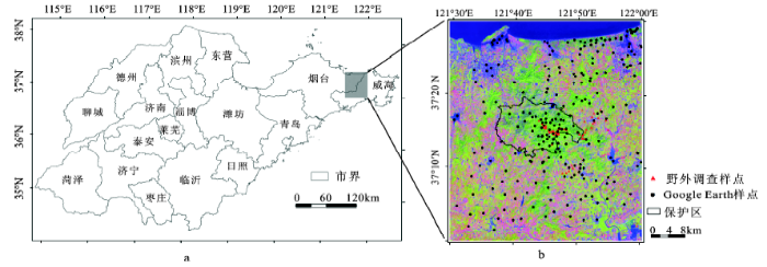
昆嵛山位于山东半岛东部(121.5°~122°E,37°~37.5°N),包括昆嵛山国家级自然保护区及其周边地区(图1),土地总面积2 503 km2。暖温带季风性气候,四季分明,雨热同期,空气湿润,温差较小,光照充足。年均气温11.9℃,年降水量984.4 mm,全年≥10℃积温3 700~4 400℃,无霜期200 d左右。昆嵛山地区地貌类型以低山丘陵为主,土壤以棕壤为主,局部有少量山顶草甸土,质地多为砂壤至中壤。该地区土地肥沃而人口密集,主要土地覆盖类型包括林地、耕地、草地、水体、裸地和建设用地等。保护区森林植被较好,森林覆盖率为82%[36],植被分布具有明显的垂直地带性,在海拔600 m以下发育着大片的天然落叶阔叶林(如麻栎Quercus acutissima、刺槐Robinia pseudoacacia)和针叶林(如赤松Pinus densiflora、黑松Pinus thunbergii),海拔600 m以上主要为草甸和灌丛。
图1 研究区位置(a)及Landsat 8 OLI影像(b)
b图为6、5、4波段合成的RGB影像图,合成时间是2015年9月27日。
Fig.1 Location of the Kunyu Mountain (a) and Landsat 8 OLI image of the study area (b)
1.2.1 Landsat 8 OLI遥感影像
本研究采用2015年9月27日的Landsat 8 OLI影像(http://earthexplorer.usgs.gov/)中的1~8波段,轨道号为119/34,研究区域无云层覆盖。Landsat 8卫星携带有OLI和TIRS(Thermal Infrared Sensor)推扫式成像仪,其中OLI包括9个波段,除全色波段为15 m分辨率外,其余波段空间分辨率为30 m。TIRS包括2个热红外波段,空间分辨率为100 m。首先借助OLI传感器的辐射定标参数对原始影像进行辐射定标,将原始影像DN值转化为像元辐射亮度值。再以FLAASH模型对影像进行大气校正,从而将辐射亮度值转化为地表真实反射率。然后对影像进行几何精校正,校正误差控制在0.1个像元以内。最后采用Gram-Schmidt算法将校正后影像的全色波段与1~7波段的影像进行融合,得到融合后的7个波段图像的分辨率提高到15 m(图1b),这有助于土地覆盖分类信息的提取。
1.2.2 DEM数据
本研究所用DEM数据是NASA提供的ASTER GDEMV2 30 m全球数字高程数据产品,源自中国科学院计算机网络信息中心地理空间数据云平台(http://www/gsclound.cn)。该数据采用一种先进算法对V1版GDEM产品进行了改进,提高了数据的空间分辨率精度和高程精度。为保持DEM与Landsat 8 OLI遥感影像的空间分辨率一致,利用最近邻方法将研究区DEM数据重采样为15 m分辨率。同时,根据DEM数据提取研究区坡度(Slope)信息,以辅助遥感影像的土地覆盖分类。
1.2.3 地面验证数据
野外验证数据包括2015年9月开展的野外调查样点数据(56个)和应用Google Earth高空间分辨率(0.61 m)遥感影像获取的同期不同地物类型样点数据(250个)(图1b),其中水体33个、建设用地69个、针叶林110个、耕地47个、裸地27个、阔叶林12个、草地8个。地面调查样点选择面积≥15 m × 15 m(约合Landsat 8 OLI影像1个像元),地表覆盖类型均匀单一的样方。Google Earth样点选取时遵循在研究区均匀分布的原则,样本面积≥0.61 m × 0.61 m,地表覆盖类型均匀单一。利用这两套数据构建土地覆盖精度评价样点库,用于昆嵛山地区土地覆盖分类的精度评价。
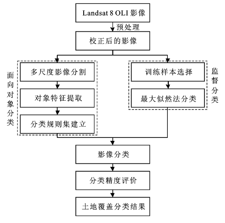
本研究总体思路如图2所示:首先,对覆盖研究区的Landsat 8 OLI影像进行预处理;其次,利用面向对象的分类方法提取土地覆盖信息,并与传统监督分类结果、地面验证数据进行对比,评价分类精度,最终获得昆嵛山地区土地覆盖分类图。
图2 昆嵛山地区土地覆盖分类技术路线
Fig.2 Flow chart of land cover classification in the Kunyu Mountation
1.3.1 土地覆盖分类方案
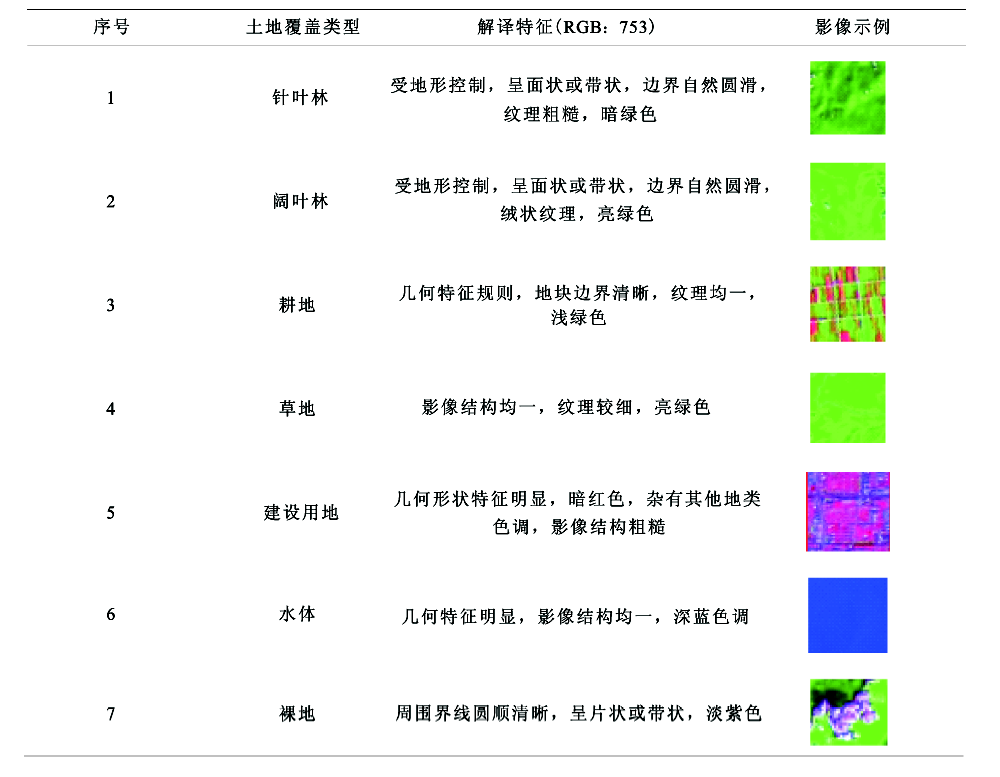
参考国际地表覆盖分类系统(Land Cover Classification System, LCCS)和张增祥[40]中国土地覆盖分类体系,结合所用数据及研究区的土地覆盖实际情况,制定以下分类方案,包括耕地、草地、裸地、建设用地、水体、针叶林和阔叶林7类。根据野外调查数据以及不同地物类型对应Landsat遥感影像波段的分析,并结合目视解译经验,获得土地覆盖类型的影像特征(表1)。
表1 研究区不同土地覆盖类型解译标志
Table 1 Interpretation signs of different land cover types in the Kunyu Mountain
 |
1.3.2 面向对象分类
面向对象分类方法突破了传统遥感影像分类方法的局限性,它综合利用影像光谱特征、质地、纹理等信息,分类结果避免“椒盐”现象的产生,具有良好的整体性。基于面向对象方法的土地覆盖分类,首先对影像进行分割,获得对象,再依据对象的光谱特征、纹理特征、形状特征和布局特征等,利用模糊分类方法对影像进行分类及信息提取。
1) 多尺度影像分割。多尺度影像分割是基于像元的从下至上的逐级区域合并,实现分割对象的异质性最小化,主要参数包括分割尺度、光谱异质性和形状异质性,其中形状异质性用光滑度和紧致度描述。异质性F定义为[41]:
式中,ω为光谱信息权重;hcolor为光谱异质性;hshape为形状异质性; hcompact为紧致度;ωcompact为紧致度权重;hsmooth为光滑度。
本研究以eCognition软件为操作平台,利用ESP(Estimation of Scale Parameter)算法[42]确定昆嵛山地区影像的最佳分割尺度。首先结合ESP得到最优分割尺度的范围,并综合考虑不同土地覆盖类型的分布特点,然后通过逐次调整分割尺度大小进行反复试验,最终建立两层次分割结构。在第一次分割中,分割尺度选为35,用以区分影像植被与非植被。在第二次分割中,分割尺度选为50,用以区分非植被中水体、裸地和建设用地。多尺度分割参数见表2。
表2 昆嵛山地区Landsat 8 OLI影像多尺度分割参数
Table 2 Scales and parameters setting of multi-resolution segmentation for the Kunyu Mountain based on Landsat 8 OLI image
| 层次 | 分割尺度 | 光谱 | 形状 | 光滑度 | 紧致度 | 波段权重 |
|---|---|---|---|---|---|---|
| 1 | 35 | 0.8 | 0.2 | 0.5 | 0.5 | 1 |
| 2 | 50 | 0.7 | 0.3 | 0.4 | 0.6 | 1 |
2) 特征选取。面向对象的分类方法通过分割使影像对象成为信息载体,由此可提取每个对象所包含像元的特征信息。特征参数主要包括光谱(植被指数、灰度值、亮度值等)、形状(面积、长宽比、形状指数等)、纹理(同质性、异质性、熵等)和类相关(拓扑关系、上下文关系)特征等[22]。根据以往研究成果[35],本研究综合选取影像对象的多种特征信息,如波段亮度值、归一化植被指数(NDVI)、面积(Area)、圆度(Roundness)、矩形拟合度(Rectangular Fit)、高程(DEM)和Slope,以期提高分类结果的精度。
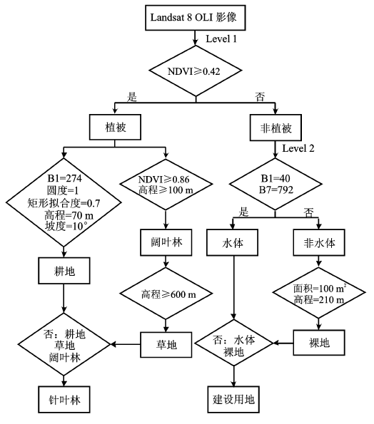
3) 分类规则建立。模糊分类方法是利用对象的特征信息构建规则集,采用人机交互的方式对每个规则的阈值进行判定,该方法能够构建多重规则集,全面刻画地物信息,适用于包含多种土地覆盖类型的分类对象。本研究根据昆嵛山地区土地覆盖分类方案,通过自动训练方式确定提取特征为NDVI≥0.42,第一次对整个影像进行全局分割(分割阈值设为35),提取植被和非植被信息(图3)。在相同的分割尺度下,使用模糊分类方法进一步提取植被内的各种地物。草地和阔叶林具有相似的光谱特征,但是草地主要分布于海拔600 m以上的地区,经自动训练后发现利用NDVI≥0.86且DEM≥100 m,以及DEM≥600 m,可以很好地提取阔叶林和草地。对于耕地的提取,经常把亮度值、形状和地形特征相结合,试验后确定当B1≤274且Roundness≤1且Rectangular Fit≥0.7且DEM≥70 m且Slope≤10°时,耕地能提取的更细更完整。在植被中,除了阔叶林、草地和耕地,其他都归为针叶林类别。
图3 Landsat 8 OLI影像土地覆盖分类规则
Level 1和Level 2分别表示多尺度影像分割的2个层次,B1和B7分别表示Landsat 8 OLI影像的第1和第7波段的亮度值
Fig.3 Rules of land cover classification based on Landsat 8 OLI image
非植被内包含的类型相对较少、同质斑块较大、结构相对简单,第一次分割时地物明显“过分割”,将提取出来的非植被信息合并。由于第一次分割得到的矢量图层中,植被内的各地类已被全部提取完毕,因此,第二次分割只针对非植被,分割尺度为50。水体影像结构单一、深蓝色调,利用亮度值B1≤40且B7≤792,能很好地区分水体和非水体。裸地和建设用地光谱特征相似,普遍亮色调、反射率较高,但裸地主要分布在山地,且分割后面积较小,经自动训练后确定Area≤100像元数且DEM≥210 m时,裸地可以较好的提取出来。在非植被中,除水体和裸地外,其他都归为建设用地。
1.3.3 监督分类
监督分类是以先验知识为基础,选择样本进行训练,以此建立统计识别函数,按照概率规则进行类别的划分。为保证结果的可靠性及代表性,本研究采用当前应用最广泛的最大似然监督分类法,与面向对象方法的分类结果进行比较。首先根据土地覆盖分类方案及样本特征描述选取训练样本,样本选择时遵循在整个研究区均匀分布的原则,通过目视判读在Landsat OLI影像上建立兴趣区,结合Google Earth高分影像对样本优化,去除非典型的兴趣区,不同土地覆盖类型之间的分离度均大于1.9,分离度良好,获得具有代表性的分类训练样本。然后,利用监督分类的最大似然分类方法,对昆嵛山地区的土地覆盖进行自动分类。
1.3.4 分类精度评估
利用野外调查获取的56个样本点和由Google Earth影像随机获取的250个验证点作为精度评价数据库,分别计算基于面向对象方法和监督分类方法进行土地覆盖分类的混淆矩阵,并计算生产者精度、用户精度、总体精度和Kappa系数。
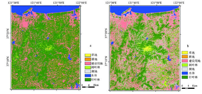
基于Landsat 8 OLI多光谱遥感数据,并辅以地形信息,利用面向对象分类和最大似然监督分类两种方法,获得昆嵛山地区土地覆盖分类结果(图4)。将面向对象的分类结果(图4a)与研究区2015年9月Landsat 8 OLI影像(图1b)进行对比与定性分析表明:分类结果与各地类的范围以及分布区域基本一致,斑点噪声较少。为进一步探究该方法的有效性,将面向对象分类方法与监督分类方法的分类结果(图4b)进行对比分析。监督分类结果较为破碎,“椒盐”噪声严重,对于光谱特征相似或相同的针叶林、阔叶林与草地、耕地与草地、裸地与建设用地等错分较多(图4b);面向对象分类结果各地类较为连续且边界清晰,错分现象较少,全图“椒盐”噪声极少,分类效果与实际情况基本吻合(图4a)。研究区域内占主导地位的土地覆盖类型是针叶林,面积为1 546.81 km2,占研究区土地总面积的61.8%;阔叶林面积很小为29.33 km2(1.2%),分布在沟谷或较高海拔的陡峭山坡[38]。草地面积占0.1%,主要分布在海拔600 m以上的山地。耕地和建设用地面积分别为74.85 km2(3.0%)和593.04 km2(23.7%),分布于昆嵛山自然保护区周围地区。裸地主要是高山上裸露的基岩,面积较小(0.3%)。水体包括研究区的河流、湖泊和临近海域,占总面积的9.9%。
图4 面向对象分类结果(a)与监督分类结果(b)对比
Fig.4 Comparisons of land cover classification based on (a) the object-oriented method with (b) the supervised classification method
地面验证数据各地类的样本数量基本符合分类结果中各土地覆盖类型的面积比重。表3和表4是利用地面验证数据对面向对象分类方法和监督分类方法的分类结果验证的混淆矩阵。从两种方法的混淆矩阵统计结果可看出,面向对象分类方法的总体精度以及各地类的生产者精度和用户精度普遍高于监督分类,前者总体精度为91.5%,Kappa系数为0.88(表3);后者总体精度为76.8%,Kappa系数为0.71(表4)。对于单一地类精度,面向对象分类提取的水体、建设用地、针叶林和草地的生产者精度非常高,分别为87.9%、100.0%、98.2%和100.0%;裸地、耕地和阔叶林次之,分别为77.8%、76.6%和75.0%。监督分类提取的建设用地、裸地、耕地和水体的生产者精度较高,分别为89.9%、88.9%、85.1%和78.8%;阔叶林次之,为75.0%;针叶林和草地较低,分别为63.6%和50.0%。除草地外,面向对象分类的各类用户精度均超过88.0%,表明其中错分的现象较少;监督分类结果的阔叶林和草地中混分了大量的针叶林,分别占针叶林总样本数的9.1%(10个)和24.5%(27个),裸地与建设用地存在大量混分现象。以上分析表明,使用Landsat 8 OLI中等空间分辨率遥感影像,结合面向对象分类方法能够达到较高的土地覆盖分类精度,这主要是因为多尺度影像分割算法可有效提取地物边界,使得分类处理的是均匀对象,而非单个像元;同时综合利用地物的光谱、几何及上下文等特征,充分挖掘邻域像元的相关性,空间异质性小,有较强的抗噪能力,有效地克服了“同物异谱”和“异物同谱”现象。
表3 面向对象分类方法分类结果混淆矩阵
Table 3 The confusion matrix of land cover classification based on the object-oriented method
| 样点数(个) | 实际类别 | |||||||||
|---|---|---|---|---|---|---|---|---|---|---|
| 水体 | 建设用地 | 针叶林 | 耕地 | 裸地 | 阔叶林 | 草地 | 总和 | 用户精度(%) | ||
| 分类类别 | 水体 | 29 | 0 | 0 | 0 | 0 | 0 | 0 | 29 | 100.00 |
| 建设用地 | 3 | 69 | 0 | 0 | 6 | 0 | 0 | 78 | 88.46 | |
| 针叶林 | 1 | 0 | 108 | 11 | 0 | 0 | 0 | 120 | 90.00 | |
| 耕地 | 0 | 0 | 1 | 36 | 0 | 0 | 0 | 37 | 97.30 | |
| 裸地 | 0 | 0 | 0 | 0 | 21 | 0 | 0 | 21 | 100.00 | |
| 阔叶林 | 0 | 0 | 1 | 0 | 0 | 9 | 0 | 10 | 90.00 | |
| 草地 | 0 | 0 | 0 | 0 | 0 | 3 | 8 | 11 | 72.73 | |
| 总和 | 33 | 69 | 110 | 47 | 27 | 12 | 8 | 306 | ||
| 生产者精度(%) | 87.88 | 100.00 | 98.18 | 76.60 | 77.78 | 75.00 | 100.00 | |||
| 总体分类精度:91.5%;Kappa系数:0.88 | ||||||||||
表4 监督分类方法分类结果混淆矩阵
Table 4 The confusion matrix of land cover classification based on the supervised classification method
| 样点数(个) | 实际类别 | |||||||||
|---|---|---|---|---|---|---|---|---|---|---|
| 水体 | 建设用地 | 针叶林 | 耕地 | 裸地 | 阔叶林 | 草地 | 总和 | 用户精度(%) | ||
| 分类类别 | 水体 | 26 | 0 | 0 | 0 | 0 | 0 | 0 | 26 | 100.00 |
| 建设用地 | 2 | 62 | 3 | 0 | 3 | 0 | 0 | 70 | 88.57 | |
| 针叶林 | 0 | 0 | 70 | 0 | 0 | 0 | 2 | 72 | 97.22 | |
| 耕地 | 0 | 0 | 0 | 40 | 0 | 0 | 0 | 40 | 100.00 | |
| 裸地 | 5 | 7 | 0 | 2 | 24 | 0 | 0 | 38 | 63.16 | |
| 阔叶林 | 0 | 0 | 10 | 0 | 0 | 9 | 2 | 21 | 42.86 | |
| 草地 | 0 | 0 | 27 | 5 | 0 | 3 | 4 | 39 | 10.26 | |
| 总和 | 33 | 69 | 110 | 47 | 27 | 12 | 8 | 306 | ||
| 生产者精度(%) | 78.79 | 89.86 | 63.64 | 85.11 | 88.89 | 75.00 | 50.00 | |||
| 总体分类精度:76.8%;Kappa系数:0.71 | ||||||||||
本研究探讨基于Landsat 8 OLI中等空间分辨率遥感数据,利用面向对象分类提取中小尺度土地覆盖信息的方法,并对昆嵛山地区2015年土地覆盖进行分类,取得了较好的分类精度与准确度。总体精度和Kappa系数分别为91.5%和0.88,除耕地、裸地和阔叶林外,主要的土地覆盖类型生产者精度均达到87%以上。昆嵛山地区的主要土地覆盖类型为针叶林,面积为1 546.81 km2,占研究区土地总面积的61.8%。通过与监督分类方法进行比较,基于Landsat 8 OLI数据的面向对象分类方法的各地类较为连续且边界清晰,错分、混分现象较少,总体分类精度和Kappa系数分别较前者提高14.7%和0.17,有效消除了“椒盐”噪声的影响,提高了信息提取精度。
在本研究中,面向对象分类方法能够有效地应用于Landsat 8 OLI中等分辨率遥感影像的土地覆盖信息提取,得到较高的分类精度,该结果可用于评价昆嵛山地区土地覆盖现状,并为大区域尺度土地覆盖分类研究提供方法参考。但仍有以下问题需继续研究:① 阔叶林和裸地分布破碎且复杂,由于中等分辨率遥感影像地物边界模糊,分割尺度太大难以准确反映它们的分布状况和边界,分割尺度过小不利于对象信息区分,致使阔叶林和裸地分类精度相对较低。如何选取遥感影像和分割尺度克服阔叶林和裸地提取精度较低问题。② 面向对象方法的分类规则多是根据经验值和人机交互试验获得,对于每类规则的精度和阈值未评估其准确性。如耕地和针叶林、草地和阔叶林两者间的阈值取值范围存在不同程度的重叠,由此造成了耕地和针叶林、草地和阔叶林间的错分、混分现象。如何采用有效方法确定其阈值以达到最佳分类效果是下步的研究方向。
The authors have declared that no competing interests exist.
| [1] |
基于HJ卫星数据与面向对象分类的土地利用/覆盖信息提取 [J].
土地利用/覆盖信息是区域气候与环境研究的基础,是土地资源规划与管理、合理开发与保护的信息保障。为此,该文选取长株潭城市群核心区为试验区,以时间序列HJ卫星影像为数据源,首先构建了时间序列归一化植被指数(normalized difference vegetation index,NDVI)、时间序列光谱第一主成分(first principal component,PC1)数据集,通过J-M(Jeffries-Matusita)距离变量可分离性分析结合地表覆盖的物候特征,确定最佳时序HJ组合数据;其次,采用面向对象的随机森林算法对研究区土地利用/覆盖信息进行分类,并对分类结果进行精度评价与比较分析。研究结果表明:采用时间序列HJ组合数据与面向对象的分类方法,提取城市土地利用/覆盖信息的总体精度和Kappa系数分别达到91.55%和0.90,其中水田、水浇地、旱地、林地、建设用地的生产者精度均达到90%及其以上;相对于时间序列基于像元分类、单时相面向对象的分类方法,该文提出的土地利用/覆盖信息提取方法的总体分类精度和Kappa系数分别提高了2.26%、0.02和6.82%、0.08,有效提高了区域土地利用/覆盖信息提取的精度,为大范围土地利用/覆盖精细化分类提供了有效的途径。
Object-oriented classification of land use/cover based on HJ satellites data .
土地利用/覆盖信息是区域气候与环境研究的基础,是土地资源规划与管理、合理开发与保护的信息保障。为此,该文选取长株潭城市群核心区为试验区,以时间序列HJ卫星影像为数据源,首先构建了时间序列归一化植被指数(normalized difference vegetation index,NDVI)、时间序列光谱第一主成分(first principal component,PC1)数据集,通过J-M(Jeffries-Matusita)距离变量可分离性分析结合地表覆盖的物候特征,确定最佳时序HJ组合数据;其次,采用面向对象的随机森林算法对研究区土地利用/覆盖信息进行分类,并对分类结果进行精度评价与比较分析。研究结果表明:采用时间序列HJ组合数据与面向对象的分类方法,提取城市土地利用/覆盖信息的总体精度和Kappa系数分别达到91.55%和0.90,其中水田、水浇地、旱地、林地、建设用地的生产者精度均达到90%及其以上;相对于时间序列基于像元分类、单时相面向对象的分类方法,该文提出的土地利用/覆盖信息提取方法的总体分类精度和Kappa系数分别提高了2.26%、0.02和6.82%、0.08,有效提高了区域土地利用/覆盖信息提取的精度,为大范围土地利用/覆盖精细化分类提供了有效的途径。
|
| [2] |
首套全球30 m分辨率土地覆被产品区域尺度精度评价——以河南省为例 [J].https://doi.org/10.11821/dlyj201608003 URL [本文引用: 1] 摘要
Accurate global land cover datasets are key environmental information for research on global changes and regional sustainable development, such as global climate change, ecosystem assessment, biodiversity conservation. However, there are still some shortcomings in showing spatial and thematic details for the existing global land cover products at medium and low resolutions (300-1000 m). Recently, GlobeLand30, a global land cover product based on Landsat images at a 30-m resolution, was produced and released by China. The product made a breakthrough in enhancing spatial resolution of global land cover products, and has a wide range of application prospects. As with any land cover products, it is necessary to carry out accuracy evaluation of GlobeLand30 in global, regional or local scales before it is widely applied. This study aims at assessing the accuracy of GlobleLand30 in Henan province with cross-comparison analyses and sampling methods respectively. Firstly, the national land use database of China at a 1100000 scale (CHINA-2010) was used as a reference data to analyze the spatial consistency between these two products. Secondly, validation samples collected from Google Earth were used to assess the producer's accuracy in spatially inconsistent areas. Finally, the overall accuracy of GlobleLand30 was assessed by field survey. Moreover, several factors influencing the accuracy of GlobleLand30 were also taken into consideration, such as land cover complexity and elevation. The following conclusions were drawn: (a) Spatial consistency between GlobleLand30 and CHINA-2010 reached up to 80.20%. There was high spatial consistency for croplands, forests and artificial surfaces, and low spatial consistency for grasslands, water bodies, shrubs, wetlands and unused lands. (b) The overall accuracy of GlobleLand30 was slightly lower than that of CHINA-2010 in spatially inconsistent areas. As for forests, producer's accuracy of GlobleLand30 was relatively higher than that of CHINA-2010. (c) It was found by field survey that the overall accuracy of GlobleLand30 was 83.33%. (d) On the one hand, with the increase of the complexity of land cover types, spatial consistency between GlobleLand30 and CHINA-2010 decreased; on the other hand, with the increase of elevation, spatial consistency between the two products decreased first and then rose, and became lower in the elevation transition zones.
Regional accuracy assessments of the first global land cover dataset at 30-meter resolution: A case study of Henan province .https://doi.org/10.11821/dlyj201608003 URL [本文引用: 1] 摘要
Accurate global land cover datasets are key environmental information for research on global changes and regional sustainable development, such as global climate change, ecosystem assessment, biodiversity conservation. However, there are still some shortcomings in showing spatial and thematic details for the existing global land cover products at medium and low resolutions (300-1000 m). Recently, GlobeLand30, a global land cover product based on Landsat images at a 30-m resolution, was produced and released by China. The product made a breakthrough in enhancing spatial resolution of global land cover products, and has a wide range of application prospects. As with any land cover products, it is necessary to carry out accuracy evaluation of GlobeLand30 in global, regional or local scales before it is widely applied. This study aims at assessing the accuracy of GlobleLand30 in Henan province with cross-comparison analyses and sampling methods respectively. Firstly, the national land use database of China at a 1100000 scale (CHINA-2010) was used as a reference data to analyze the spatial consistency between these two products. Secondly, validation samples collected from Google Earth were used to assess the producer's accuracy in spatially inconsistent areas. Finally, the overall accuracy of GlobleLand30 was assessed by field survey. Moreover, several factors influencing the accuracy of GlobleLand30 were also taken into consideration, such as land cover complexity and elevation. The following conclusions were drawn: (a) Spatial consistency between GlobleLand30 and CHINA-2010 reached up to 80.20%. There was high spatial consistency for croplands, forests and artificial surfaces, and low spatial consistency for grasslands, water bodies, shrubs, wetlands and unused lands. (b) The overall accuracy of GlobleLand30 was slightly lower than that of CHINA-2010 in spatially inconsistent areas. As for forests, producer's accuracy of GlobleLand30 was relatively higher than that of CHINA-2010. (c) It was found by field survey that the overall accuracy of GlobleLand30 was 83.33%. (d) On the one hand, with the increase of the complexity of land cover types, spatial consistency between GlobleLand30 and CHINA-2010 decreased; on the other hand, with the increase of elevation, spatial consistency between the two products decreased first and then rose, and became lower in the elevation transition zones.
|
| [3] |
Optical remotely sensed time series data for land cover classification: A review [J].https://doi.org/10.1016/j.isprsjprs.2016.03.008 URL [本文引用: 3] 摘要
Accurate land cover information is required for science, monitoring, and reporting. Land cover changes naturally over time, as well as a result of anthropogenic activities. Monitoring and mapping of land cover and land cover change in a consistent and robust manner over large areas is made possible with Earth Observation (EO) data. Land cover products satisfying a range of science and policy information needs are currently produced periodically at different spatial and temporal scales. The increased availability of EO data articularly from the Landsat archive (and soon to be augmented with Sentinel-2 data) oupled with improved computing and storage capacity with novel image compositing approaches, have resulted in the availability of annual, large-area, gap-free, surface reflectance data products. In turn, these data products support the development of annual land cover products that can be both informed and constrained by change detection outputs. The inclusion of time series change in the land cover mapping process provides information on class stability and informs on logical class transitions (both temporally and categorically). In this review, we present the issues and opportunities associated with generating and validating time-series informed annual, large-area, land cover products, and identify methods suited to incorporating time series information and other novel inputs for land cover characterization.
|
| [4] |
A land cover change detection and classification protocol for updating Alaska NLCD 2001 to 2011 [J].https://doi.org/10.1016/j.rse.2017.04.021 URL [本文引用: 1] 摘要
Monitoring and mapping land cover changes are important ways to support evaluation of the status and transition of ecosystems. The Alaska National Land Cover Database (NLCD) 2001 was the first 30-m resolution baseline land cover product of the entire state derived from circa 2001 Landsat imagery and geospatial ancillary data. We developed a comprehensive approach named AKUP11 to update Alaska NLCD from 2001 to 2011 and provide a 10-year cyclical update of the state's land cover and land cover changes. Our method is designed to characterize the main land cover changes associated with different drivers, including the conversion of forests to shrub and grassland primarily as a result of wildland fire and forest harvest, the vegetation successional processes after disturbance, and changes of surface water extent and glacier ice/snow associated with weather and climate changes. For natural vegetated areas, a component named AKUP11-VEG was developed for updating the land cover that involves four major steps: 1) identify the disturbed and successional areas using Landsat images and ancillary datasets; 2) update the land cover status for these areas using a SKILL model (System of Knowledge-based Integrated-trajectory Land cover Labeling); 3) perform decision tree classification; and 4) develop a final land cover and land cover change product through the postprocessing modeling. For water and ice/snow areas, another component named AKUP11-WIS was developed for initial land cover change detection, removal of the terrain shadow effects, and exclusion of ephemeral snow changes using a 3-year MODIS snow extent dataset from 2010 to 2012. The overall approach was tested in three pilot study areas in Alaska, with each area consisting of four Landsat image footprints. The results from the pilot study show that the overall accuracy in detecting change and no-change is 90% and the overall accuracy of the updated land cover label for 2011 is 86%. The method provided a robust, consistent, and efficient means for capturing major disturbance events and updating land cover for Alaska. The method has subsequently been applied to generate the land cover and land cover change products for the entire state of Alaska.
|
| [5] |
Potential contributions of remote sensing to ecosystem service assessments [J].https://doi.org/10.1177/0309133314528942 URL [本文引用: 1] 摘要
Ecological and conservation research has provided a strong scientific underpinning to the modeling of ecosystem services (ESs) over space and time, by identifying the ecological processes and components of biodiversity (ecosystem service providers, functional traits) that drive ES supply. Despite this knowledge, efforts to map the distribution of ESs often rely on simple spatial surrogates that provide incomplete and non-mechanistic representations of the biophysical variables they are intended to proxy. However, alternative data sets are available that allow for more direct, spatially nuanced inputs to ES mapping efforts. Many spatially explicit, quantitative estimates of biophysical parameters are currently supported by remote sensing, with great relevance to ES mapping. Additional parameters that are not amenable to direct detection by remote sensing may be indirectly modeled with spatial environmental data layers. We review the capabilities of modern remote sensing for describing biodiversity, plant traits, vegetation condition, ecological processes, soil properties, and hydrological variables and highlight how these products may contribute to ES assessments. Because these products often provide more direct estimates of the ecological properties controlling ESs than the spatial proxies currently in use, they can support greater mechanistic realism in models of ESs. By drawing on the increasing range of remote sensing instruments and measurements, data sets appropriate to the estimation of a given ES can be selected or developed. In so doing, we anticipate rapid progress to the spatial characterization of ecosystem services, in turn supporting ecological conservation, management, and integrated land use planning.
|
| [6] |
Mapping major land cover dynamics in Beijing using all Landsat images in Google Earth Engine [J].https://doi.org/10.1016/j.rse.2017.02.021 URL [本文引用: 2] 摘要
Land cover in Beijing experienced a dramatic change due to intensive human activities, such as urbanization and afforestation. However, the spatial patterns of the dynamics are still unknown. The archived Landsat images provide an unprecedented opportunity to detect land cover changes over the past three decades. In this study, we used the Normalized Difference Vegetation Index (NDVI) trajectory to detect major land cover dynamics in Beijing. Then, we classified the land cover types in 2015 with the Google Earth Engine (GEE) cloud calculation. By overlaying the latest land cover types and the spatial distribution of land cover dynamics, we determined the main types where a land cover change occurred. The overall change detection accuracy for three types (vegetation loss associated with negative change in NDVI, vegetation gain associated with positive change in NDVI, and no changes) is 86.13%. We found that the GEE is a fast and powerful tool for land cover mapping, and we obtained a classification map with an overall accuracy of 86.61%. Over the past 3002years, 1402.2802km 2 of land was with vegetation loss and 1090.3802km 2 of land was revegetated in Beijing. The spatial pattern of vegetation loss and vegetation gain shows significant differences in different zones from the center of the city. We also found that 1162.7102km 2 of land was converted to urban and built-up, whereas 918.3602km 2 of land was revegetated to cropland, shrub land, forest, and grassland. Moreover, 202.6702km 2 and 156.7502km 2 of the land was transformed to forest and shrub land in the plain of Beijing that were traditionally used for cropland and housing.
|
| [7] |
Finer resolution observation and monitoring of global land cover: first mapping results with Landsat TM and ETM+ data [J].https://doi.org/10.1080/01431161.2012.748992 URL [本文引用: 2] 摘要
We have produced the first 30 m resolution global land-cover maps using Landsat Thematic Mapper (TM) and Enhanced Thematic Mapper Plus (ETM+) data. We have classified over 6600 scenes of Landsat TM data after 2006, and over 2300 scenes of Landsat TM and ETM+ data before 2006, all selected from the green season. These images cover most of the world's land surface except Antarctica and Greenland. Most of these images came from the United States Geological Survey in level L1T (orthorectified). Four classifiers that were freely available were employed, including the conventional maximum likelihood classifier (MLC), J4.8 decision tree classifier, Random Forest (RF) classifier and support vector machine (SVM) classifier. A total of 91,433 training samples were collected by traversing each scene and finding the most representative and homogeneous samples. A total of 38,664 test samples were collected at preset, fixed locations based on a globally systematic unaligned sampling strategy. Two software tools, Global Analyst and Global Mapper developed by extending the functionality of Google Earth, were used in developing the training and test sample databases by referencing the Moderate Resolution Imaging Spectroradiometer enhanced vegetation index (MODIS EVI) time series for 2010 and high resolution images from Google Earth. A unique land-cover classification system was developed that can be crosswalked to the existing United Nations Food and Agriculture Organization (FAO) land-cover classification system as well as the International Geosphere-Biosphere Programme (IGBP) system. Using the four classification algorithms, we obtained the initial set of global land-cover maps. The SVM produced the highest overall classification accuracy (OCA) of 64.9% assessed with our test samples, with RF (59.8%), J4.8 (57.9%), and MLC (53.9%) ranked from the second to the fourth. We also estimated the OCAs using a subset of our test samples (8629) each of which represented a homogeneous area greater than 500 m 500 m. Using this subset, we found the OCA for the SVM to be 71.5%. As a consistent source for estimating the coverage of global land-cover types in the world, estimation from the test samples shows that only 6.90% of the world is planted for agricultural production. The total area of cropland is 11.51% if unplanted croplands are included. The forests, grasslands, and shrublands cover 28.35%, 13.37%, and 11.49% of the world, respectively. The impervious surface covers only 0.66% of the world. Inland waterbodies, barren lands, and snow and ice cover 3.56%, 16.51%, and 12.81% of the world, respectively.
|
| [8] |
Meta-discoveries from a synthesis of satellite-based land-cover mapping research [J].https://doi.org/10.1080/01431161.2014.930206 URL [本文引用: 1] 摘要
Since the launch of the first land-observation satellite (Landsat-1) in 1972, land-cover mapping has accumulated a wide range of knowledge in the peer-reviewed literature. However, this knowledge has never been comprehensively analysed for new discoveries. Here, we developed the first spatialized database of scientific literature in English about land-cover mapping. Using this database, we tried to identify the spatial temporal patterns and spatial hotspots of land-cover mapping research around the world. Among other findings, we observed (1) a significant mismatch between hotspot areas of land-cover mapping and areas that are either hard to map or rich in biodiversity; (2) mapping frequency is positively related to economic conditions; (3) there is no obvious temporal trend showing improvement in mapping accuracy; (4) images with more spectral bands or a combination of data types resulted in increased mapping accuracies; (5) accuracy differences due to algorithm differences are not as large as those due to various types of data used; and (6) the complexity of a classification system decreases its mapping accuracy. We recommend that one way to improve our understanding of the challenges, advances, and applications of previous land-cover mapping is for journals to require area-based information at the time of manuscript submission. In addition, building a standard protocol for systematic assessment of land-cover mapping efforts at the global scale through international collaboration is badly needed.
|
| [9] |
A meta-analysis of remote sensing research on supervised pixel-based land-cover image classification process: General guidelines for practitioners and future research [J].https://doi.org/10.1016/j.rse.2016.02.028 URL [本文引用: 2] 摘要
61We synthesize results from numerous studies of image classification methods.61Meta-analysis is used to quantify improvements in accuracy of methods.61Including texture information provided greatest improvement in accuracy.61Support vector machines achieved highest accuracy among classification algorithms.61Index creation and feature extraction offered minor improvements.
|
| [10] |
Using the 500m MODIS land cover product to derive a consistent continental scale 30m Landsat land cover classification [J].https://doi.org/10.1016/j.rse.2017.05.024 URL [本文引用: 1] 摘要
Classification is a fundamental process in remote sensing used to relate pixel values to land cover classes present on the surface. Over large areas land cover classification is challenging particularly due to the cost and difficulty of collecting representative training data that enable classifiers to be consistent and locally reliable. A novel methodology to classify large volume Landsat data using high quality training data derived from the 50002m MODIS land cover product is demonstrated and used to generate a 3002m land cover classification for all of North America between 20°N and 50°N. Publically available 3002m global monthly Web-enabled Landsat Data (GWELD) products generated from every available Landsat 7 ETM02+ and Landsat 5 TM image for a three year period, that are defined aligned to the MODIS land products and are consistently pre-processed data (cloud-screened, saturation flagged, atmospherically corrected and normalized to nadir BRDF adjusted reflectance), were classified. The MODIS 50002m land cover product was filtered judiciously, using only good quality pixels that did not change land cover class in 2009, 2010 or 2011, followed by automated selection of spatially corresponding 3002m GWELD temporal metric values, to define a large training data set sampled across North America. The training data were sampled so that the class proportions were the same as the North America MODIS land cover product class proportions and corresponded to 1% of the 50002m and <020.005% of the 3002m pixels. Thirty nine GWELD temporal metrics for every 3002m North America pixel location were classified using (a) a single random forest, and (b) a locally adaptive method with a random forest classifier derived and applied locally and the classification results spatially mosaicked together. The land cover classification results appeared geographically plausible and at synoptic scale were similar to the MODIS land cover product. Detailed visual inspection revealed that the locally adaptive random forest classifications and associated classification confidences were generally more coherent than the single random forest classification results. The level of agreement between the 3002m classifications and the MODIS land cover product derived training data was assessed by bootstrapping the random forest implementation. The locally adaptive random forest classification had higher overall agreement (95.44%, 0.9443 kappa) than the single random forest classification (93.13%, 0.9195 kappa). The paper concludes with a discussion of future research including the potential for automated global land cover classification.
|
| [11] |
遥感影像信息提取的方式 [J].https://doi.org/10.3969/j.issn.1672-5867.2014.02.046 URL [本文引用: 2] 摘要
介绍了利用遥感影像的光谱特性、空间特性、极化特性和时间特性提取遥感影像信息的常用方法。
Remote sensing information extraction method .https://doi.org/10.3969/j.issn.1672-5867.2014.02.046 URL [本文引用: 2] 摘要
介绍了利用遥感影像的光谱特性、空间特性、极化特性和时间特性提取遥感影像信息的常用方法。
|
| [12] |
Classification and change detection of built-up lands from Landsat-7 ETM+ and Landsat-8 OLI/TIRS imageries: A comparative assessment of various spectral indices [J].https://doi.org/10.1016/j.ecolind.2015.03.037 URL [本文引用: 1] 摘要
Since the mid-1990s, various spectral indices have been proposed for the rapid and accurate classification of built-up lands from satellite imageries. However, a comprehensive comparison between these indices as applied to various satellite imageries is still lacking. Hence, this study examines and compares the performance of six spectral indices in the classification and change detection of built-up lands from Landsat-7 ETM+ (Enhanced Thematic Mapper Plus) and Landsat-8 OLI/TIRS (Operational Land Imager/Thermal Infrared Sensor) imageries. It includes three mid-infrared (MIR)-based indices, i.e. the urban index (UI), the normalized difference built-up index (NDBI), and the index-based built-up index (IBI), two proposed visible (Vis)-based indices, i.e. the VrNIR-BI and VgNIR-BI or the visible red/green-based built-up indices, and one thermal infrared (TIR)-based index, i.e. the normalized difference impervious surface index (NDISI). In addition, a water index, i.e. the modified normalized difference water index (MNDWI), was also derived. Otsu's method was used to separate water from the non-water areas on the MNDWI map. Subsequently, a water mask was produced and used to mask all the built-up index maps, leaving only the non-water areas. Using the same thresholding method, the non-water areas of all the built-up index maps were classified into built-up and non-built-up classes. The classification accuracy was assessed using 5000 reference points for each image. The results show that the VrNIR-BI, with an overall accuracy of 92.50% (Landsat-7) and 92.28% (Landsat-8), and the VgNIR-BI, with 92.78% (Landsat-7) and 92.14% (Landsat-8) overall accuracy, were more robust and superior. They were more accurate than the other indices by up to 8% for the Landsat-7 ETM+ image and 10% for the Landsat-8 image OLI/TIRS image. The qualitative assessment results also supported these quantitative findings. The results also show indications that the detected spatiotemporal urban LUC changes (i.e. built-up expansions) based on the VrNIR-BI and VgNIR-BI were also the most accurate. These indices, i.e. the proposed Vis-based indices, have better potential in separating built-up lands from dry vegetation, which has been an important challenge in the application of spectral indices for classifying built-up lands from satellite imageries.
|
| [13] |
An evaluation of time-series smoothing algorithms for land-cover classification using MODIS-NDVI multi-temporal data [J].https://doi.org/10.1016/j.rse.2015.12.023 URL [本文引用: 1] 摘要
61Four smoothing algorithms were examined for MODIS land-cover classification.61All smoothing algorithms can significantly reduce intra-class variability.61Smoothed data resulted in large inconsistencies of Jeffries–Matusita (JM) measures.61Fourier smoothing algorithm performed best in improving classification accuracy.
|
| [14] |
融合时间特征的遥感影像分类 [J].https://doi.org/10.6046/gtzyyg.2017.01.06 URL [本文引用: 1] 摘要
为了克服基于光谱纹理特征的影像分类法的不足,提出一种融合时间特征的遥感影像分类方法。以历史时期土地利用矢量图为辅助数据,对新时期遥感影像进行带约束的影像分割以获取像斑;采用迭代统计的方法计算新时期遥感影像的地物类别转移概率;利用地物类别转移概率表达时间特征,将其融入到像斑的后验概率中,构建顾及时间特征的像斑联合概率;依据后验概率最大原则获取影像分类结果。采用Quick Bird遥感影像进行的实验结果表明:与基于光谱纹理特征的分类方法相比,所提出的方法能够显著提高影像分类的精度,总体分类精度与kappa系数分别提高了9.8%和17.9%,验证了所提方法的可行性和可靠性。
Remote sensing image classification based on fusion of temporal features .https://doi.org/10.6046/gtzyyg.2017.01.06 URL [本文引用: 1] 摘要
为了克服基于光谱纹理特征的影像分类法的不足,提出一种融合时间特征的遥感影像分类方法。以历史时期土地利用矢量图为辅助数据,对新时期遥感影像进行带约束的影像分割以获取像斑;采用迭代统计的方法计算新时期遥感影像的地物类别转移概率;利用地物类别转移概率表达时间特征,将其融入到像斑的后验概率中,构建顾及时间特征的像斑联合概率;依据后验概率最大原则获取影像分类结果。采用Quick Bird遥感影像进行的实验结果表明:与基于光谱纹理特征的分类方法相比,所提出的方法能够显著提高影像分类的精度,总体分类精度与kappa系数分别提高了9.8%和17.9%,验证了所提方法的可行性和可靠性。
|
| [15] |
A semi-automated approach for the generation of a new land use and land cover product for Germany based on Landsat time-series and Lucas in-situ data [J].https://doi.org/10.1080/2150704X.2016.1249299 URL [本文引用: 1] 摘要
Information on land cover and land use at high spatial resolutions is essential for advancing earth system science as well as for environmental monitoring to support decision-making and reporting processes. In view of this, we present the first version of the DFD Land Use and Land Cover Product for Germany, DFD-LULC_DE, for the year 2014, generated from 702 Landsat-7 and Landat-8 scenes at 30 m resolution. The results were derived based on a fully automated preprocessing chain that integrates data acquisition, radiometric, atmospheric and topographic correction, as well as spectral090009temporal feature extraction for all Landsat surface reflectance bands, brightness temperature and various spectral indices. The classification followed a two-step approach: first, an initial classification is performed using a Random Forest classifier trained on ground truth data obtained from the LUCAS survey of EUROSTAT, followed by a semi-automated sampling of additional training data to further improve the initial classification results. Automatic selection of appropriate training samples is based on the vote entropy derived from the initial classification, thereby keeping manual user interaction low. The approach demonstrated is promising, also with respect to a European wide application, and contributes towards the advancement and enhancement of the DLR-DFD090005s processing chains, which are directed towards the generation of land cover products at regular intervals being of central importance to related land monitoring and reporting services.
|
| [16] |
Land cover classification of Landsat data with phenological features extracted from time series MODIS NDVI data [J].https://doi.org/10.3390/rs61111518 URL [本文引用: 1] 摘要
Temporal-related features are important for improving land cover classification accuracy using remote sensing data. This study investigated the efficacy of phenological features extracted from time series MODIS Normalized Difference Vegetation Index (NDVI) data in improving the land cover classification accuracy of Landsat data. The MODIS NDVI data were first fused with Landsat data via the Spatial and Temporal Adaptive Reflectance Fusion Model (STARFM) algorithm to obtain NDVI data at the Landsat spatial resolution. Next, phenological features, including the beginning and ending dates of the growing season, the length of the growing season, seasonal amplitude, and the maximum fitted NDVI value, were extracted from the fused time series NDVI data using the TIMESAT tool. The extracted data were integrated with the spectral data of the Landsat data to improve classification accuracy using a maximum likelihood classifier (MLC) and support vector machine (SVM) classifier. The results indicated that phenological features had a statistically significant effect on improving the land cover classification accuracy of single Landsat data (an approximately 3% increase in overall classification accuracy), especially for vegetation type discrimination. However, the phenological features did not improve on statistical measures including the maximum, the minimum, the mean, and the standard deviation values of the time series NDVI dataset, especially for human-managed vegetation types. Regarding different classifiers, SVM could achieve better classification accuracy than the traditional MLC classifier, but the improvement in accuracy obtained using advanced classifiers was inferior to that achieved by involving the temporally derived features for land cover classification.
|
| [17] |
基于面向对象的QUICKBIRD数据和SAR数据融合的地物分类 [J].https://doi.org/10.3969/j.issn.1000-5382.2016.09.010 URL [本文引用: 1] 摘要
为了实现精确植被类型信息提取,以福建省三明市将乐林场Quickbird影像和Radarsat-2全极化影像作为基础数据,探讨高空间分辨率光学遥感影像与SAR(合成孔径雷达)全极化影像融合进行地表覆盖及森林类型识别的可行性.采用面向对象多尺度分割方法对Quickbird全色与多光谱的融合影像进行处理,SAR影像采用Gram-Schmidt融合方法处理,运用处理的Quickbird与SAR的融合影像,分类提取植被的光谱、纹理和几何特征信息,建立类层次结构,并对分类结果进行比较分析.结果表明:基于对象与知识的方法对高空间分辨率影像分类取得了较好的分类效果,多源遥感数据分类的总体精度为0.903.
An object-based fusion of QUICKBIRD data and RADARSAT SAR data for classification analysis .https://doi.org/10.3969/j.issn.1000-5382.2016.09.010 URL [本文引用: 1] 摘要
为了实现精确植被类型信息提取,以福建省三明市将乐林场Quickbird影像和Radarsat-2全极化影像作为基础数据,探讨高空间分辨率光学遥感影像与SAR(合成孔径雷达)全极化影像融合进行地表覆盖及森林类型识别的可行性.采用面向对象多尺度分割方法对Quickbird全色与多光谱的融合影像进行处理,SAR影像采用Gram-Schmidt融合方法处理,运用处理的Quickbird与SAR的融合影像,分类提取植被的光谱、纹理和几何特征信息,建立类层次结构,并对分类结果进行比较分析.结果表明:基于对象与知识的方法对高空间分辨率影像分类取得了较好的分类效果,多源遥感数据分类的总体精度为0.903.
|
| [18] |
Multi-source remotely sensed data fusion for improving land cover classification [J].https://doi.org/10.1016/j.isprsjprs.2016.12.008 URL [本文引用: 1] 摘要
Although many advances have been made in past decades, land cover classification of fine-resolution remotely sensed (RS) data integrating multiple temporal, angular, and spectral features remains limited, and the contribution of different RS features to land cover classification accuracy remains uncertain. We proposed to improve land cover classification accuracy by integrating multi-source RS features through data fusion. We further investigated the effect of different RS features on classification performance. The results of fusing Landsat-8 Operational Land Imager (OLI) data with Moderate Resolution Imaging Spectroradiometer (MODIS), China Environment 1A series (HJ-1A), and Advanced Spaceborne Thermal Emission and Reflection (ASTER) digital elevation model (DEM) data, showed that the fused data integrating temporal, spectral, angular, and topographic features achieved better land cover classification accuracy than the original RS data. Compared with the topographic feature, the temporal and angular features extracted from the fused data played more important roles in classification performance, especially those temporal features containing abundant vegetation growth information, which markedly increased the overall classification accuracy. In addition, the multispectral and hyperspectral fusion successfully discriminated detailed forest types. Our study provides a straightforward strategy for hierarchical land cover classification by making full use of available RS data. All of these methods and findings could be useful for land cover classification at both regional and global scales.
|
| [19] |
基于MODIS NDVI时间序列的土地覆盖分层分类方法研究 [J].
以时间分辨率为16 d、空间分辨率为250 m的MODIS NDVI时间序列数据为主要数据源,利用两种滤波方法对NDVI时间序列进行滤波处理,并基于J-M距离比较了两种方法的类别可分性,同时结合短波红外光谱反射率数据、DEM数据,采用分层分类的方法,对中国东北3省进行了土地覆盖制图研究。在分类过程中,遵循逐级分类、先利用单一特征波段后结合多种特征波段的原则,综合使用阈值法、支持向量机(SVM)、人工神经网络(ANN)、C5.0决策树分类法对研究区内的土地覆盖类别进行逐层分类细化。根据已有的土地覆盖数据和高分辨率遥感影像对最终分类结果进行精度评价,总体分类精度为84.61%,Kappa系数为0.8262。
Hierarchical land cover classification based on MODIS NDVI time-series .
以时间分辨率为16 d、空间分辨率为250 m的MODIS NDVI时间序列数据为主要数据源,利用两种滤波方法对NDVI时间序列进行滤波处理,并基于J-M距离比较了两种方法的类别可分性,同时结合短波红外光谱反射率数据、DEM数据,采用分层分类的方法,对中国东北3省进行了土地覆盖制图研究。在分类过程中,遵循逐级分类、先利用单一特征波段后结合多种特征波段的原则,综合使用阈值法、支持向量机(SVM)、人工神经网络(ANN)、C5.0决策树分类法对研究区内的土地覆盖类别进行逐层分类细化。根据已有的土地覆盖数据和高分辨率遥感影像对最终分类结果进行精度评价,总体分类精度为84.61%,Kappa系数为0.8262。
|
| [20] |
Geospatial knowledge-based verification and improvement of GlobeLand30 [J].https://doi.org/10.1007/s11430-016-5318-4 URL [本文引用: 1] 摘要
Abstract Assuring the quality of land-cover data is one of the major challenges for large- area mapping projects. Although the use of geospatial knowledge and ancillary data in improving land-cover classification has been studied since the early 1980s, mature methods and efficient supporting tools are still lacking. This paper presents a geospatial knowledge-based verification and improvement approach for global land cover (GLC) mapping at 30-m resolution. A set of verification rules is derived from three types of land cover and its change knowledge (natural, cultural and temporal constraints). A group of web-based supporting tools is developed to facilitate the integration of and access to large amounts of ancillary data and to support online data manipulation and analysis as well as collaborative verification workflows. With this approach, two 30-m GLC datasets (GlobeLand-2000 and GlobeLand-2010) were verified and modified. The results indicate that the data quality of GlobeLand30 has been largely improved.
|
| [21] |
基于面向对象技术的鄱阳湖湿地地物分类研究 [J].https://doi.org/10.11873/j.issn.1004-0323.2016.3.0543 URL Magsci [本文引用: 1] 摘要
<p>使用RadarsatG2全极化雷达数据,基于面向对象技术对图像进行分割,分析各类地物的散射特征,并对分割对象进行特征提取,依此设计各类地物的提取因子并对鄱阳湖湿地进行地物信息提取,最后利用实地采样数据和同期的高分一号影像数据对分类结果进行验证.研究表明:采用面向对象技术并结合地物散射特征设计的提取因子,可以有效克服雷达图像分类中常见的斑点现象,提高湿地分类精度.</p>
Study on classification of Poyang Lake wetland using object-oriented technology .https://doi.org/10.11873/j.issn.1004-0323.2016.3.0543 URL Magsci [本文引用: 1] 摘要
<p>使用RadarsatG2全极化雷达数据,基于面向对象技术对图像进行分割,分析各类地物的散射特征,并对分割对象进行特征提取,依此设计各类地物的提取因子并对鄱阳湖湿地进行地物信息提取,最后利用实地采样数据和同期的高分一号影像数据对分类结果进行验证.研究表明:采用面向对象技术并结合地物散射特征设计的提取因子,可以有效克服雷达图像分类中常见的斑点现象,提高湿地分类精度.</p>
|
| [22] |
Segmentation parameter selection for object-based land-cover mapping from ultra high resolution spectral and elevation data [J].https://doi.org/10.1080/01431161.2017.1302107 URL [本文引用: 3] 摘要
Segmentation is the primary task for image analysis in many practical applications, such as object-based image analysis. Segmentation algorithms need to have properly estimated parameters to provide efficient performance and reliable results. Due to the fact that some features have different shapes and spectral characteristics, it is hard to find the proper parameters for the whole image. In this article, we propose a new method for resolving this issue through the building of a hierarchy of segmentations, based on the number of land-cover classes in the image, namely segmentation scale space (SSS). Both spectral and elevation data are employed in order to enhance the SSS and to obtain a single segmentation for the image. The performance of the proposed algorithm is evaluated using two data sets, which consist of ultra-high resolution aerial images and elevation data with ground sampling distance of 5 and 9 cm, respectively. The experiments demonstrate the efficiency of enhanced segmentation with respect to over and under segmentation cases. Finally, the comparative analysis shows that the accuracy of the proposed method is superior to the classical methods.
|
| [23] |
A review of supervised object-based land-cover image classification [J].https://doi.org/10.1016/j.isprsjprs.2017.06.001 URL [本文引用: 1] 摘要
Object-based image classification for land-cover mapping purposes using remote-sensing imagery has attracted significant attention in recent years. Numerous studies conducted over the past decade have investigated a broad array of sensors, feature selection, classifiers, and other factors of interest. However, these research results have not yet been synthesized to provide coherent guidance on the effect of different supervised object-based land-cover classification processes. In this study, we first construct a database with 28 fields using qualitative and quantitative information extracted from 254 experimental cases described in 173 scientific papers. Second, the results of the meta-analysis are reported, including general characteristics of the studies (e.g., the geographic range of relevant institutes, preferred journals) and the relationships between factors of interest (e.g., spatial resolution and study area or optimal segmentation scale, accuracy and number of targeted classes), especially with respect to the classification accuracy of different sensors, segmentation scale, training set size, supervised classifiers, and land-cover types. Third, useful data on supervised object-based image classification are determined from the meta-analysis. For example, we find that supervised object-based classification is currently experiencing rapid advances, while development of the fuzzy technique is limited in the object-based framework. Furthermore, spatial resolution correlates with the optimal segmentation scale and study area, and Random Forest (RF) shows the best performance in object-based classification. The area-based accuracy assessment method can obtain stable classification performance, and indicates a strong correlation between accuracy and training set size, while the accuracy of the point-based method is likely to be unstable due to mixed objects. In addition, the overall accuracy benefits from higher spatial resolution images (e.g., unmanned aerial vehicle) or agricultural sites where it also correlates with the number of targeted classes. More than 95.6% of studies involve an area less than 300 ha, and the spatial resolution of images is predominantly between 0 and 2 m. Furthermore, we identify some methods that may advance supervised object-based image classification. For example, deep learning and type-2 fuzzy techniques may further improve classification accuracy. Lastly, scientists are strongly encouraged to report results of uncertainty studies to further explore the effects of varied factors on supervised object-based image classification.
|
| [24] |
Landsat-8: Science and product vision for terrestrial global change research [J].https://doi.org/10.1016/j.rse.2014.02.001 URL [本文引用: 2] 摘要
61Initial understanding of Landsat 8 capabilities, new science and applications.61Landsat Science Team identified priorities.61Derived ‘higher-level’ Landsat products.61International synergies with other moderate resolution remote sensing satellites.61Successor Landsat mission requirements.
|
| [25] |
Land cover classification using Landsat 8 Operational Land Imager data in Beijing, China [J].https://doi.org/10.1080/10106049.2014.894586 URL [本文引用: 2] 摘要
The successful launch of Landsat 8 provides a new data source for monitoring land cover, which has the potential to significantly improve the characterization of the earth s surface. To assess data performance, Landsat 8 Operational Land Imager (OLI) data were first compared with Landsat 7 ETM + data using texture features as the indicators. Furthermore, the OLI data were investigated for land cover classification using the maximum likelihood and support vector machine classifiers in Beijing. The results indicated that (1) the OLI data quality was slightly better than the ETM + data quality in the visible bands, especially the near-infrared band of OLI the data, which had a clear improvement; clear improvement was not founded in the shortwave-infrared bands. Moreover, (2) OLI data had a satisfactory performance in terms of land cover classification. In summary, OLI data were a reliable data source for monitoring land cover and provided the continuity in the Landsat earth observation.
|
| [26] |
Continuous change detection and classification of land cover using all available Landsat data [J].https://doi.org/10.1016/j.rse.2014.01.011 URL 摘要
61A new algorithm for Continuous Change Detection and Classification of land cover61All available (a total of 519) Landsat images from Path 12 Row 31 were used.61It can detect many kinds of land cover change continuously.61It can provide land cover maps for any given time.61The results were accurate both in change detection and classification.
|
| [27] |
Classification and assessment of land cover and land use change in southern Ghana using dense stacks of Landsat 7 ETM+ imagery [J].https://doi.org/10.1016/j.rse.2016.07.016 URL 摘要
61Southern Ghana, equatorial study area with extensive cloud cover year round61Dense stack classification approach with Landsat 7 ETM+ time-series data61Novel spectral vegetation index for natural vegetation/agriculture classification61Land cover and land use change from c. 2000 to c. 2010 are mapped and quantified.61Predominant changes are natural veg. to ag. (69%) and ag. to built (6%).
|
| [28] |
Seasonal multitemporal land-cover classification and change detection analysis of Bochum, Germany, using multitemporal Landsat TM data [J].https://doi.org/10.1080/01431161.2015.1125558 URL [本文引用: 1] 摘要
The 40-year Landsat time series makes it possible to continuously map and examine land-cover changes. By using images from two dates in each classification year, we can improve the classification accuracy of monotemporal approaches for each year and reduce the misclassification problem between bare lands or impervious surface and vegetation cover types. Two pairs of multitemporal cloud-free Landsat Thematic Mapper images (the first pair from 1 May and 9 June 1986 and the second from 4 June 2010 and 20 April 2011) were selected from the area of the city of Bochum, Germany. The multitemporal image sets were classified separately using the maximum likelihood classification algorithm. The overall accuracies of the monotemporal classifications for 1 May and 9 June 1986 were, respectively, 77.1 and 75.4% while the overall accuracy of the multitemporal classification for 1986 was 82.1%. The overall accuracies of the monotemporal classification for 4 June 2010 and 20 April 2011 were, respectively, 81.4 and 77.9%, while the overall accuracy of the multitemporal classification for 2010/2011 was 88.2%. Post-classification comparison change detection was used to determine change in land-cover type. The proportion of urban area increased from 55.3 to 61.1% for the whole area, while that of agricultural land decreased from 24.8 to 21.8% and bare land from 3.6 to 0.2%. Forest and water bodies remained almost unchanged between 1986 and 2011.
|
| [29] |
新一代Landsat系列卫星:Landsat 8遥感影像新增特征及其生态环境意义 [J].https://doi.org/10.5846/stxb201305030912 URL Magsci [本文引用: 1] 摘要
美国Landsat 8卫星的成功发射使一度中断的Landsat对地观测得以继续。Landsat 8除了保持Landsat 7卫星的基本特征外,还在波段的数量、波段的光谱范围和影像的辐射分辨率上进行了改进。基于该卫星的首幅影像,针对这些新的特性进行了分析和研究。研究发现:(1)新增的卷云波段有助于区别点云和高反射地物;(2)卷云波段设计的波长范围位于粘土矿物光谱反射的强吸收带,有利于土壤与建筑不透水面信息的区别; (3)新增的深蓝波段有助于水体悬浮物浓度的监测;(4)全色影像波长范围的收窄有利于该影像上植被和非植被的区别; (5)辐射分辨率的提高可避免极亮/极暗区的灰度过饱和现象,这对反射率极低的水体的细微特征识别有很大帮助。显然,Landsat 8这些新增的优点将会对全球生态环境变化的监测产生积极的作用。
Analysis of new characteristics of the first Landsat 8 image and their eco-environmental significance .https://doi.org/10.5846/stxb201305030912 URL Magsci [本文引用: 1] 摘要
美国Landsat 8卫星的成功发射使一度中断的Landsat对地观测得以继续。Landsat 8除了保持Landsat 7卫星的基本特征外,还在波段的数量、波段的光谱范围和影像的辐射分辨率上进行了改进。基于该卫星的首幅影像,针对这些新的特性进行了分析和研究。研究发现:(1)新增的卷云波段有助于区别点云和高反射地物;(2)卷云波段设计的波长范围位于粘土矿物光谱反射的强吸收带,有利于土壤与建筑不透水面信息的区别; (3)新增的深蓝波段有助于水体悬浮物浓度的监测;(4)全色影像波长范围的收窄有利于该影像上植被和非植被的区别; (5)辐射分辨率的提高可避免极亮/极暗区的灰度过饱和现象,这对反射率极低的水体的细微特征识别有很大帮助。显然,Landsat 8这些新增的优点将会对全球生态环境变化的监测产生积极的作用。
|
| [30] |
Including land cover change in analysis of greenness trends using all available Landsat 5, 7, and 8 images: A case study from Guangzhou, China (2000-2014) [J].https://doi.org/10.1016/j.rse.2016.03.036 URL [本文引用: 2] 摘要
61All available Landsats 5–8 data were used to analyze greenness trends.61Data from Landsat 8 were not completely consistent with the data from Landsats 5–7.61Landsat 8 EVI values were less biased than Landsat 8 NDVI values.61The total EVI change estimated by SLT was 14.3% higher than CCDC estimation.61On average Guangzhou experienced a 0.0567 increase in EVI from 2000 to 2014.
|
| [31] |
Landsat 8 OLI影像新增特征对土地覆盖遥感分类的影响分析 [J].https://doi.org/10.3969/j.issn.1673-7105.2015.03.012 URL [本文引用: 2] 摘要
本研究针对OLI影像在辐射分辨率、近红外波段和全色波段的光谱范围以及波段数量等方面进行的调整,与ETM+进行比较分析,探究其对土地覆盖遥感分类的影响。实验发现:1)辐射分辨率的提高有利于地类之间的区分,进而提高分类的总体精度;2)近红外波段范围的调整有利于识别水体边界,对分类总体精度影响不大;3)新增的深蓝波段可明显提高水体、不透水层的分类精度,进而提高总体分类精度,卷云波段的加入不利于地类之间的区分,降低分类精度;4)全色波段范围的收窄可明显提高林草地、耕地的分类精度,裸土的分类精度也有所提高,有利于区分植被与非植被信息。研究结果能够推广OLI影像的使用,并对应用OLI影像进行土地覆盖分类具有借鉴意义。
Effects of new characteristics of Landsat 8 operational land imager (OLI) data on land-cover remote sensing classification .https://doi.org/10.3969/j.issn.1673-7105.2015.03.012 URL [本文引用: 2] 摘要
本研究针对OLI影像在辐射分辨率、近红外波段和全色波段的光谱范围以及波段数量等方面进行的调整,与ETM+进行比较分析,探究其对土地覆盖遥感分类的影响。实验发现:1)辐射分辨率的提高有利于地类之间的区分,进而提高分类的总体精度;2)近红外波段范围的调整有利于识别水体边界,对分类总体精度影响不大;3)新增的深蓝波段可明显提高水体、不透水层的分类精度,进而提高总体分类精度,卷云波段的加入不利于地类之间的区分,降低分类精度;4)全色波段范围的收窄可明显提高林草地、耕地的分类精度,裸土的分类精度也有所提高,有利于区分植被与非植被信息。研究结果能够推广OLI影像的使用,并对应用OLI影像进行土地覆盖分类具有借鉴意义。
|
| [32] |
New land-cover maps of Ghana for 2015 using Landsat 8 and three popular classifiers for biodiversity assessment [J].https://doi.org/10.1080/01431161.2017.1312619 URL [本文引用: 1] 摘要
(2017). New land-cover maps of Ghana for 2015 using Landsat 8 and three popular classifiers for biodiversity assessment. International Journal of Remote Sensing: Vol. 38, No. 14, pp. 4008-4021. doi: 10.1080/01431161.2017.1312619
|
| [33] |
The first all-season sample set for mapping global land cover with Landsat-8 data [J].https://doi.org/10.1016/j.scib.2017.03.011 URL [本文引用: 2] 摘要
We report the world's first all-season training and validation sample sets for global land cover classification with Landsat-8 data.Prior to this,such samples were only available at a single date primarily from the growing season.It is unknown how much limitation such a single-date sample has to mapping global land cover in other seasons of the year.To answer this question,we selected available Landsat-8 images from four seasons and collected training and validation samples from them.We compared the performances of training samples in different seasons using Random Forest algorithm.We found that the use of training samples from any individual season would result in the best overall classification accuracy when validated by samples in the same season.The global overall accuracy from combined best seasonal results was 67.2% when classifying the 11 Level-1 classes in the Finer Resolution Observation and Monitoring of Global Land Cover(FROM-GLC) classification system.The use of training samples from all seasons(named all-season training sample set hereafter) produced an overall accuracy of 67.0%.We also tested classification within 10 latitude 60 longitude zones using all-season training subsample within each zone and obtained an overall accuracy of 70.2%.This indicates that properly grouped subsamples in space can help improve classification accuracies.All the results in this study seem to suggest that it is possible to use an all-season training sample set to reach global optimality with universal applicability in classifying images acquired at any time of a year for global land cover mapping.
|
| [34] |
Mapping land cover and land use from object-based classification: an example from a complex agricultural landscape [J].https://doi.org/10.1080/01431161.2015.1088674 URL [本文引用: 1] 摘要
From its inception, land-use and land-cover mapping have been major themes in remote-sensing research and applications. Although frequently considered together, land use and land cover (LULC) are defined differently, with land use referring to the economic function of the Earth surface and land cover to its natural or engineered biophysical cover. Land cover can be observed directly using remote sensing, but land use must be inferred from the cover type. In this study, we test whether object-based image analysis (OBIA) can improve the land-cover and land-use classification in a complex agricultural landscape located along the border between Poland and Ukraine. We quantitatively compared the results of OBIA-based versus per-pixel classifications for both land cover and land use, respectively. Our results show that land-cover classification was not significantly improved when OBIA-based methods were used. Although overall classification accuracy was modest, land-use classification was significantly improved when OBIA-based methods were applied using both spectral and spatial/geometric features of image objects, but not when spectral or spatial/geometric features were used independently. Our results suggest that in anthropogenically altered landscapes where the geometry and arrangement of surface spatial structure may convey land-use information, use of OBIA-based techniques may provide a powerful tool for improving classification.
|
| [35] |
面向对象分类的决策树方法探讨—以Landsata-8 OLI为例 [J].https://doi.org/10.16251/j.cnki.1009-2307.2016.06.025 URL [本文引用: 2] 摘要
针对目前遥感影像分类中面向对象和决策树相结合的研究较少的情况,该文提出基于C5.0决策树的面向对象分类方法,并以广州市从化区进行实证研究。基于Landsat-8OLI影像数据,采用面向对象分类对影像进行多尺度分割,提取出影像对象的光谱、纹理特征以及影像对象相对应的DEM信息;然后利用C5.0决策树根据特征信息来挖掘分类规则;最后根据规则对分割后影像进行分类。结果表明,基于C5.0决策树的面向对象影像分类精度高、效果好,总体精度和Kappa系数分别为89.75%和87.5%。该方法可准确、快速地提取土地利用/覆被信息。
Object-oriented classification based on C5.0 algorithm .https://doi.org/10.16251/j.cnki.1009-2307.2016.06.025 URL [本文引用: 2] 摘要
针对目前遥感影像分类中面向对象和决策树相结合的研究较少的情况,该文提出基于C5.0决策树的面向对象分类方法,并以广州市从化区进行实证研究。基于Landsat-8OLI影像数据,采用面向对象分类对影像进行多尺度分割,提取出影像对象的光谱、纹理特征以及影像对象相对应的DEM信息;然后利用C5.0决策树根据特征信息来挖掘分类规则;最后根据规则对分割后影像进行分类。结果表明,基于C5.0决策树的面向对象影像分类精度高、效果好,总体精度和Kappa系数分别为89.75%和87.5%。该方法可准确、快速地提取土地利用/覆被信息。
|
| [36] |
昆嵛山国家级自然保护区物种水平指标的分析与研究 [J].https://doi.org/10.3969/j.issn.1005-7129.2014.02.008 URL [本文引用: 2] 摘要
对昆嵛山国家级自然保护区进行物种水平指标的分析与研究,结果表明:在物种多样性方面,Ⅴ级的分布面积最大,占保护区总面积的21%;Ⅳ级的次之,为28%;Ⅲ级处于中间位置,为21%;Ⅱ级和Ⅰ级的分布面积较小,分别为13%和7%。在植被盖度方面,Ⅴ级的分布面积最大,占保护区总面积的69%;Ⅳ级次之,为17%;Ⅲ级、Ⅱ级和Ⅰ级的分布面积较小,分别为9%、4%和1%。在物种水平方面,Ⅳ级的分布面积最大,占保护区总面积的43%;Ⅴ级和Ⅲ级的分布面积相差不大,分别为26%和25%;Ⅱ级以下的分布面积较小,仅为6%。
Analysis and research of species level indicator in Kunyu Mountain national nature reserve .https://doi.org/10.3969/j.issn.1005-7129.2014.02.008 URL [本文引用: 2] 摘要
对昆嵛山国家级自然保护区进行物种水平指标的分析与研究,结果表明:在物种多样性方面,Ⅴ级的分布面积最大,占保护区总面积的21%;Ⅳ级的次之,为28%;Ⅲ级处于中间位置,为21%;Ⅱ级和Ⅰ级的分布面积较小,分别为13%和7%。在植被盖度方面,Ⅴ级的分布面积最大,占保护区总面积的69%;Ⅳ级次之,为17%;Ⅲ级、Ⅱ级和Ⅰ级的分布面积较小,分别为9%、4%和1%。在物种水平方面,Ⅳ级的分布面积最大,占保护区总面积的43%;Ⅴ级和Ⅲ级的分布面积相差不大,分别为26%和25%;Ⅱ级以下的分布面积较小,仅为6%。
|
| [37] |
昆嵛山典型植物群落生态学特性 [J].
在群落调查的基础上,采用优势度、丰富度、物种多样性、均匀度和种间相遇几率几个指标,对昆嵛山主要的天然植物群落和人工植物群落的生态学特性进行研究。结果表明:不同植被类型中,灌草层物种数不同,物种的优势度和占优势的物种也各不相同;表征群落生态学特性的各个指数之间有很强的相关性,其中Shannon-Wiener指数<EM>H</EM>与其它指数的相关性最高;在以<EM>H</EM>为代表的不同层次多样性的比较中发现,不同植被类型,灌木层和草本层多样性的关系不同,但它们的平均值趋于稳定,即灌木层和草本层的物种多样性有很强的互补性;同一植被类型的不同群落间由于环境的异质性,多样性往往也不同;天然或者人工抚育强度小的4种植被类型比较,灌草层物种多样性的顺序是杂木林>赤松林>黑松林>麻栎林,在赤松林和黑松林中加入人工管理或者人工管理加强以后则变为黑松林>赤松林>杂木林>麻栎林,同时,黑松林和赤松林中乔木层的生长也受到了很大的影响,中度干扰理论在其中起了重要的作用,综合看来,对赤松林的管理达到了中度干扰的水平,而对黑松林的管理则有些过度。
Ecological characteristics of typical plant communities in Kunyu Mountain .
在群落调查的基础上,采用优势度、丰富度、物种多样性、均匀度和种间相遇几率几个指标,对昆嵛山主要的天然植物群落和人工植物群落的生态学特性进行研究。结果表明:不同植被类型中,灌草层物种数不同,物种的优势度和占优势的物种也各不相同;表征群落生态学特性的各个指数之间有很强的相关性,其中Shannon-Wiener指数<EM>H</EM>与其它指数的相关性最高;在以<EM>H</EM>为代表的不同层次多样性的比较中发现,不同植被类型,灌木层和草本层多样性的关系不同,但它们的平均值趋于稳定,即灌木层和草本层的物种多样性有很强的互补性;同一植被类型的不同群落间由于环境的异质性,多样性往往也不同;天然或者人工抚育强度小的4种植被类型比较,灌草层物种多样性的顺序是杂木林>赤松林>黑松林>麻栎林,在赤松林和黑松林中加入人工管理或者人工管理加强以后则变为黑松林>赤松林>杂木林>麻栎林,同时,黑松林和赤松林中乔木层的生长也受到了很大的影响,中度干扰理论在其中起了重要的作用,综合看来,对赤松林的管理达到了中度干扰的水平,而对黑松林的管理则有些过度。
|
| [38] |
昆嵛山赤松林不同林型结构特征与生产力的研究 [J].
根据立地主导因子(坡向、坡位、土层厚度)与混交状况,对山东昆嵛山赤松林划分林型,将其归纳为4个林型组(山脊阳坡薄土赤松林,阳坡中土厚土赤松林,阴坡中土厚土赤松林,阴坡阳坡中厚土松阔混交林)。并对不同林型的群落结构与林分生产力进行了研究。结果表明:赤松纯林面积较大,林龄多为30~50年生的中龄林、同龄林,混交树种多为栎类(麻栎、栓皮栎等)。林下灌木层与草本层发育较好,样地中常见约20个灌木种,近40种草本。林木与林分生产力较低,立地较好的中龄林林分蓄积量约30~50m3/hm2,平均材积生长量1~2m3/hm2;松阔混交林蓄积量超过90m3/hm2,年均材积生长量达2~3m3/hm2。
Community structure characteristics and productivity of varied Pinus densiflora forest types in Kunyu Mountain .
根据立地主导因子(坡向、坡位、土层厚度)与混交状况,对山东昆嵛山赤松林划分林型,将其归纳为4个林型组(山脊阳坡薄土赤松林,阳坡中土厚土赤松林,阴坡中土厚土赤松林,阴坡阳坡中厚土松阔混交林)。并对不同林型的群落结构与林分生产力进行了研究。结果表明:赤松纯林面积较大,林龄多为30~50年生的中龄林、同龄林,混交树种多为栎类(麻栎、栓皮栎等)。林下灌木层与草本层发育较好,样地中常见约20个灌木种,近40种草本。林木与林分生产力较低,立地较好的中龄林林分蓄积量约30~50m3/hm2,平均材积生长量1~2m3/hm2;松阔混交林蓄积量超过90m3/hm2,年均材积生长量达2~3m3/hm2。
|
| [39] |
昆嵛山生产力特征及其与植被指数、生物多样性关系 [D].The net primary production characteristics and its relationship with vegetation indices, biodiversity at Kunyu Mountain . |
| [40] |
|
| [41] |
基于ENVISAT ASAR、Landsat TM与DEM的泥炭沼泽信息提取方法 [J].https://doi.org/10.13203/j.whugis20140669 URL [本文引用: 1] 摘要
泥炭沼泽是重要的湿地类型之一,对全球变化和生态平衡具有重要意义。本研究在野外实地调查和对比不同地物类型在不同极化方式下雷达影像后向散射系数差异的基础上,以ENVISAT ASAR、Landsat TM与数字高程模型(digital elevation model,DEM)数据为基本信息源,利用面向对象与决策树分类相结合的遥感影像分类方法,实现对小兴安岭西部泥炭沼泽典型分布区不同泥炭沼泽类型的空间分布信息提取,总体分类精度93.54%,Kappa系数0.92。结果表明,该方法在泥炭沼泽信息提取方面具有较大的应用潜力,相对于先前的研究,在分类精度上有一定的提高。
Peatland extraction based on ENVISAT ASAR, Landsat TM and DEM data .https://doi.org/10.13203/j.whugis20140669 URL [本文引用: 1] 摘要
泥炭沼泽是重要的湿地类型之一,对全球变化和生态平衡具有重要意义。本研究在野外实地调查和对比不同地物类型在不同极化方式下雷达影像后向散射系数差异的基础上,以ENVISAT ASAR、Landsat TM与数字高程模型(digital elevation model,DEM)数据为基本信息源,利用面向对象与决策树分类相结合的遥感影像分类方法,实现对小兴安岭西部泥炭沼泽典型分布区不同泥炭沼泽类型的空间分布信息提取,总体分类精度93.54%,Kappa系数0.92。结果表明,该方法在泥炭沼泽信息提取方面具有较大的应用潜力,相对于先前的研究,在分类精度上有一定的提高。
|
| [42] |
ESP-A tool to estimate scale parameter for multiresolution image segmentation of remotely sensed data [J].https://doi.org/10.1080/13658810903174803 URL [本文引用: 1] 摘要
The spatial resolution of imaging sensors has increased dramatically in recent years, and so too have the challenges associated with extracting meaningful information from their data products. Object-based image analysis (OBIA) is gaining rapid popularity in remote sensing science as a means of bridging very high spatial resolution (VHSR) imagery and GIS. Multiscalar image segmentation is a fundamental step in OBIA, yet there is currently no tool available to objectively guide the selection of appropriate scales for segmentation. We present a technique for estimating the scale parameter in image segmentation of remotely sensed data with Definiens Developer. The degree of heterogeneity within an image-object is controlled by a subjective measure called the cale parameter, as implemented in the mentioned software. We propose a tool, called estimation of scale parameter (ESP), that builds on the idea of local variance (LV) of object heterogeneity within a scene. The ESP tool iteratively generates image-objects at multiple scale levels in a bottom-up approach and calculates the LV for each scale. Variation in heterogeneity is explored by evaluating LV plotted against the corresponding scale. The thresholds in rates of change of LV (ROC-LV) indicate the scale levels at which the image can be segmented in the most appropriate manner, relative to the data properties at the scene level. Our tests on different types of imagery indicated fast processing times and accurate results. The simple yet robust ESP tool enables fast and objective parametrization when performing image segmentation and holds great potential for OBIA applications.
|

/
| 〈 |
|
〉 |