孟祥锐 , 张树清
, 张树清
Meng Xiangrui, Zhang Shuqing
中图分类号: F129.9
文献标识码: A
文章编号: 1000-0690(2018)11-1914-10
通讯作者:
收稿日期: 2018-01-2
修回日期: 2018-09-6
网络出版日期: 2018-11-20
版权声明: 2018 《地理科学》编辑部 本文是开放获取期刊文献,在以下情况下可以自由使用:学术研究、学术交流、科研教学等,但不允许用于商业目的.
基金资助:
作者简介:
作者简介:孟祥锐(1981-),女,吉林梨树人,讲师,博士研究生,主要研究方向为地理信息系统算法研究。E-mail: 32965786@qq.com
展开
摘要
以洪河国家级自然保护区为研究对象,应用卷积神经网络(CNN)方法进行高分辨率湿地遥感影像的分类研究,并与基于光谱支持向量机(SP-SVM)的方法和基于纹理及光谱的支持向量机(TSP-SVM)的方法进行了对比。结果显示,对于所选取的2个研究区域,CNN分类方法的全局精度高于SP-SVM方法5.61%和5%,高于TSP-SVM方法4.18%和4.15%。尤其对于部分湿地植被的分类精度明显高于SP-SVM和TSP-SVM方法。研究表明,卷积神经网络为湿地识别的精细划分提供了有利的手段。
关键词:
Abstract
On the high-resolution remote sensing imagery, the feature of the ground object spectra is very rich. The spectral differences are increased within the same type, differences between the categories are decreased, and the phenomenon is obvious that the same object with different spectra and the different objects with the same spectrum. Under high-resolution remote sensing imagery, the application of shallow classification models for classifying wetland remote sensing cannot unearth sufficient information, while the adoption of deep-structure models for classification of high-resolution wetland remote sensing images can fully utilize the spatial structure information of images. Deep-featured representations allow layered learning from simple concepts to higher-level complex patterns such as textures, segments, and objects. Convolutional neural network is a very representative network structure in deep learning, and it has been gradually applied to the classification of remote sensing images in the past two years. This article constructs a proper framework for the study of area image classification by selecting the size of convolution kernels and pooling kernels, classifiers and activation functions, and optimizing the number of convolutional layers. A study on the classification of different vegetation types in Sanjiang Plain Honghe National Nature Reserve is carried out through experiments. A comparison of accuracy is made between support vector machines method based on the spectrum and the support vector machines method based on the texture and spectrum. Experiments show that: 1) When adding the texture spectral features to the classification method, the classifying accuracy by SVM method based on Pixel is slightly improved compared with the SVM method based on spectrum. The CNN classification method based on patch with spectrum, texture, size, color and other semantic features, of which classification accuracy is generally higher than about 4% of the TSP-SVM method. 2) Pixel based classification methods can produce salt and pepper noise effects for misclassified pixels, and it’s hard to deal with the abundant Information from high-resolution data. The key feature of CNN’s algorithm is that it does not require manual pre-extraction of features, and the processing and classifying of images is performed in an end-to-end manner, so it has a stronger generalization ability. 3) However, in the experiment, it is also found that , on the one hand, the accuracy of the CNN classifier on the boundary is not as good as that of the SVM classifier, and there is a phenomenon of uncertainty along the boundary of the object in the classification, which leads to excessive smoothness to a certain extent. On the other hand, in the use of the CNN classifier, although the spectral features are significant, there is little spatial information and it may be misclassified. The experimental results conclude that the CNN as a deep structure classifier explores the complex spatial patterns hidden in high-resolution remote sensing images, and it can extract more abundant semantic features of the ground. Therefore, the use of the CNN method is more accurate to classify high-resolution wetland remote sensing images, and it can provide decision support for real-time monitoring, management, and protection of wetlands.
Keywords:
湿地是一种特殊的自然综合体,是地球上水陆相互作用形成的生态系统,是世界上公认的最宝贵的自然资源之一,在调节径流、抵御洪水、改善区域气候以及维持生态平衡方面都有不可取代的作用[1,2]。遥感技术由于具有省时省力、多时相、多平台、信息量大等优点,在监测和记录各种类型湿地方面具有诸多优势[3,4]。因此,采用先进的技术手段对湿地植被群落及其周围的土地利用类型进行适时、动态的监测是十分必要的[5,6]。随着遥感技术的不断发展,遥感图像的空间分辨率越来越高,地物的空间细节信息更加丰富,更有利于湿地植被群落和土地利用类型的识别。然而,同一类地物由于外部环境的影响可能表现出强烈的光谱差异,而不同的地物类型,尤其是自然植被没有明显的边界,具有很强的同质性。因此,湿地遥感分类的精度问题一直是困扰湿地遥感发展的瓶颈之一。
随着计算机技术的不断发展,一些新湿地分类方法应用到了湿地遥感的分类当中。决策树作为数据挖掘的一种方法,具有灵活、直观、运算效率高等特点,在遥感影像分类和专题信息提取中已有广泛的应用,并应用到了草原湿地的评估和淡水[7]地的沼泽信息提取[8,9]中。20世纪80年代,神经网络方法开始应用于湿地遥感影像的分类中[10,11]。面向对象的分类方法的主要特点是针对研究的对象,能够发掘出更多的有效特征信息,更加接近人的目视解译思维[12,13]。支持向量机是在统计学习理论基础上发展的通用学习方法,近几年在湿地遥感图像分类中得到了广泛的应用[14,15,16]。应用这些浅层的分类模型进行湿地遥感的分类不能挖掘出深层的上下文语义信息,而采用深层结构的模型对高分辨率的湿地遥感影像进行分类能够充分利用影像的空间结构信息。深层特征表示可以从简单的概念到更高层次的复杂图案(如纹理,片段和对象)进行分层学习[17]。目前,图像识别分类的最主流技术是深度神经网络,其中卷积神经网络(Convolutional Neural Network,CNN)最为出名。国内外已有学者将卷积神经网络应用在了遥感图像的分类和识别中[18,19,20,21],但是很少有人研究卷积神经网络方法在湿地分类中的性能和效果。
本文通过对卷积核和池化核的尺寸和大小、分类器和激活函数的选择以及卷积层数的选择优化,构建适合研究区域遥感影像分类的框架结构,通过实验对三江平原洪河自然保护区的不同植被类型进行了分类研究,并同基于光谱的支持向量机的方法和基于纹理光谱的支持向量机方法进行了精度对比,为湿地遥感影像的精细分类提供了可能。
卷积神经网络是一种专门为处理高维网格型数据而设计的深度学习神经网络。它的优点之一是避免了对图像的前期预处理过程,直接从原始像素出发,经过极少的预处理,就能够识别出视觉上面的规律。卷积神经网络与其他深度学习模型最大的区别是具有权值共享和局部连接的特点[22]。权值共享极大的减少了参数的数量,局部连接的结构不仅可以简化网络计算量,还可以有效提取方向线段、拐点、端点等初级视觉特征和空间信息。
卷积层由多个卷积核组成,用于计算不同的特征图。具体来说,特征映射的每个神经元连接到前一层中的相邻神经元的区域。这样的相邻的神经元在前一层被称为神经元的感受野。通过对第一层的特征图进行卷积和学习,将卷积结果应用非线性激活函数进行处理,就会得到新的特征映射。在卷积处理的过程中,为了生成每个特征映射,卷积核由输入的所有空间位置共享。完整的特征图是由所有的卷积核共同计算获得。具体的,第l层的第k个特征图在(i,j)位置计算的特征值为
式中,
在神经网络中,把处于活跃状态的神经元称为激活态,处在非活跃状态的神经元称为抑制态,激活函数赋予了神经元自我学习和适应的能力。激活函数的主要作用是调节权重和误差。用
传统的激活函数有sigmoid函数和tanh函数。近几年来,近似生物神经元的激活函数在神经网络中变得越来越流行,这一类典型的激活函数为ReLU函数和Softplus函数。其中,ReLU函数也是遥感图像分类领域中最常用到的激活函数。
池化层也称为下采样层或子采样层,是CNN网络的另一个核心结构层。通过对输入数据的各个维度进行空间的采样,可以进一步降低数据规模,并且对输入数据具有局部线性转换的不变性,增强网络的泛化处理能力。池化层的每个特征图都连接到其前一个卷积层的相应特征图。每一个第l层的第k个特征在(i,j)位置对应的池化函数pool(.)可以定义为:
式中,
经过了多次卷积和池化以后,输入特征的维度已经下降至可以直接采用前馈网络来处理。在全连接层,所有的二维图像的特征图拼接为一维特征作为全连接的输入[24]。全连接层的每一个神经元都与前一层的神经元相互连接,而同一层的神经元之间不连接。第l层神经元j的全连接层o可定义为:
式中,l表示当前层,
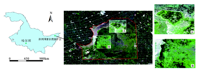
洪河自然保护区(133°34′28″~133°46′39″E,47°42′18″~47°52′18″N)地处中国黑龙江省三江平原东北部的同江市和抚远市的交汇处,保护区的面积为21 835
实验采用2017年7月5日过境的高分二号(GF-2)卫星的全色影像和多光谱影像,其中全色影像的空间分辨率为 1 m,多光谱影像的空间分辨率为 4 m。高分二号卫星所选波段参数如表1所示。研究区域遥感影像采用了Gram -Schmidt 融合算法进行波段融合,融合后的精度为1 m。根据不同波段的组合成像,选取4,3,2组合方式合成假彩色图像。该方式的波段组合植被显示为红色系,便于对湿地植被群落的划分。实验区域选取洪河自然保护区的2个区域,2个区域都有明显的湿地植被群落分布(图1)。其中实验区域A(1 886×1 402 像元)为洪河自然保护区的核心区域,分布着保护区的典型地物类型;实验区域B(1 984×1 431 像元) 位于保护区的西南部,研究区域除了湿地植被群落以外,还有耕地土地利用类型分布(图1)。通过对研究区域的土地覆被情况的实际调查和查阅相关文献,采用分层随机方案采集研究区域的样本点,训练样本和测试样本各占样本点数量的50%,如表2所示。
表1 GF-2卫星传感器参数
Table 1 Satellite sensor parameters of GF-2
| 相机 | 光谱范围(μm) | 分辨率(m) |
|---|---|---|
| PAN | 0.45~0.90 | 1 |
| MSS1 | 0.45~0.52 | 4 |
| MSS2 | 0.52~0.59 | 4 |
| MSS3 | 0.63~0.69 | 4 |
| MSS4 | 0.77~0.89 | 4 |
表2 研究区实验分类体系及样本点数量
Table 2 Experimental classification system and number of sample points in study area
| 研究区域 | 分类 | 特征 | 训练样本 | 测试样本 |
|---|---|---|---|---|
| A | 漂筏苔草群落 | 紫色或浅绿色,片状 | 292 | 292 |
| 毛果苔草群落 | 亮白色,片状 | 306 | 306 | |
| 乌拉苔草群落 | 深绿色,片状 | 260 | 260 | |
| 小叶章群落 | 翠绿色,片状 | 294 | 294 | |
| 旱生杂草 | 灰绿色,状不规则多边形 | 260 | 260 | |
| 林地 | 墨绿色,簇状片状分布 | 320 | 320 | |
| 无植被水域 | 黑色或黑灰色,不规则多边形 | 200 | 200 | |
| B | 漂筏苔草群落 | 紫色或浅绿色,片状 | 288 | 288 |
| 毛果苔草群落 | 亮白色,片状 | 275 | 275 | |
| 乌拉苔草群落 | 深绿色,片状 | 310 | 310 | |
| 小叶章群 | 翠绿色,片状 | 240 | 240 | |
| 旱生杂草 | 灰绿色,状不规则多边形 | 258 | 258 | |
| 林地 | 墨绿色,簇状片状分布 | 310 | 310 | |
| 无植被水域 | 黑色或黑灰色,不规则多边形 | 216 | 216 | |
| 耕地 | 深绿色或浅绿色,片状 | 264 | 264 |
2.2.1 精度评价指标
对分类结果的评价采用了混淆矩阵的方法。通过将每个测试像元的位置和分类与分类图像中的相应位置的分类相比较计算得到分类的精度。混淆矩阵的重要评价指标为总体分类精度、Kappa系数、漏分误差、错分误差、制图精度和用户精度,而制图精度与用户精度是决定不同地物信息提取的关键所在[15]。
2.2.2 精度对比基准
遥感图像纹理特征的常用提取方法主要有:马尔可夫随机场(MarkovRan-domField,MRF)、Gabor小波变换和灰度共生矩阵(Gray-Level Co-occurrence Matrix,GLCM)。本文采取GLCM的方法提取研究区域的纹理特征。GLCM方法与方向有关,单一方向的抽取会造成图像选择时纹理特征的变换,因此需要在不同的方向进行抽取。GLCM实施中另外2个关键问题就是特征统计量的选择和分析窗口的大小。
2.3.1 卷积神经网络参数设置
应用卷积神经网络对遥感图像进行分类的过程中,CNN模型的构建和参数的设置直接影响了影像的分类精度。在已有的文献中,都采用了不同的模型结构和参数对遥感图像进行分类[27]。遥感图像的数据数据来源涉及到了中等分辨率的遥感影像,高分辨率的遥感影像[31]和高光谱遥感影像[28,29,30]。
根据研究区域的实际情况,对比试验分类结果,本次实验所采用的卷积神经网络的结构框架如图2所示。输入图像的尺寸为11×11×4像素,其中4为图像的波段数,卷积核尺寸为3×3,卷积核数量分别为32和64。池化层选择了最大池化的方法,池化核尺寸为2×2,为了调节模型的非线性操作,在全连接层使用的激活函数为Relu函数,模型的分类器选取的是SoftMax。模型中通过使用Dropout[32]方法,为网络建立强大的稀疏正则化,实现了较好的模型泛化,解决了遥感图像分类中的过拟合问题。在卷积层都加入了Dropout,其随机化选择的概率取值为0.5,迭代次数为1 000,学习率为0.006 5。
图2 实验采用的卷积神经网络结构
Fig.2 Convolutional neural network structure used in the experiment
2.3.2 纹理特征提取参数设置
本文对遥感影像的4个波段进行主成分分析,对包含了88.2%信息的第一主成分提取纹理信息。用GLCM提取了常用的8种纹理特征,分别为:平均值、方差、熵、同质性、对比性、不相似性、角二阶矩、相关性。灰度共生矩阵的生成方向分别选取0°、45°、90°、135°这4个方向。纹理特征提取的窗口分别对3×3、5×5、7×7、9×9、11×11尺寸进行了对比。对比中发现,大的窗口能提取出大尺度的明显的纹理,但可能会导致边缘模糊,造成某些细节纹理特征的损失;小窗口能够提取出较细致的纹理特征,但是会出现很多噪声,加剧椒盐现象。本次实验中,根据实验结果对比选取5×5的窗口。
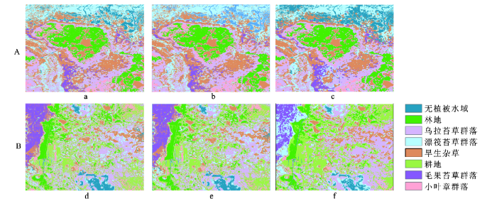
在前期的实验中,通过应用已有的分类方法对湿地遥感影像的分类精度进行对比,选取基于光谱的SVM方法(SP-SVM)、基于纹理光谱的SVM(TSP-SVM)方法与CNN方法进行分类精度的对比分析,图3为分类结果对比图。为了更好的观察分类结果,对比2种分类方法的差别,分别在2个研究区域中选取了子集进行分析结果的对比。
图3 研究区域分类结果
a,b,c分别为研究区域A的SP-SVM、TSP-SVM和CNN的分类结果;d,e,f分别为研究区域B的SP-SVM、TSP-SVM和CNN的分类结果
Fig.3 Results of regional classification
高分辨率遥感影像上,同类地物内的光谱差异增大,类别间的光谱差异减少,同物异谱和同谱异物现象明显。从而使得信息提取的结果会出现更加严重的“椒盐现象”,从而影响分类的精度。近几年,支持向量机[33](SVM)、随机森林[34](RF)等基于像素的机器学习方法普遍应用于遥感图像的分类中,并且对计算方法也做了很多的研究和改进。这些方法都属于浅层模型结构[35],浅层模型的输入和输出中间是有限的线性或者非线性变换组合,并不能充分的学习到图像中复杂的结构信息[36]。实验结果如图3所示,通过对SP-SVM、TSP-SVM和CNN方法的比较,SP-SVM的分类结果中“椒盐现象”非常严重,TSP-SVM方法分类的结果中,“椒盐现象”有了缓解,而CNN方法的分类结果中基本上的控制了“椒盐现象”的发生。在图4子集a中,更加清晰的体现了CNN方法在高分辨率湿地遥感影像的分类中可以极大的避免“椒盐现象”。
图4 研究区域A的典型区域(a,b,c)分类结果对比
Fig.4 Three typical image subsets (a, b and c) with their classification results in study site A
在高分辨率湿地影像的分类中,由于植被类型间的边界不明显,并且存在着2种或多种植被交汇生长的情况。从图4子集b的分类结果表明由于旱生杂草和乌拉苔草部分光谱特征较相似,因此SP-SVM方法中将乌拉苔草错分为旱生杂草,TSP-SVM方法中,由于考虑了植被的纹理特征,因此错分的比例降低了。而在CNN方法中则较准确的划分了乌拉苔草和旱生杂草。通过对比,图4子集c表明通过CNN方法更加准确的提取到了小叶章。
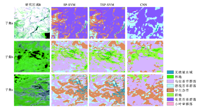
对于研究区域B,由于区域中有耕地分布。在2017年7月的遥感影像中,耕地与湿地植被的光谱特征十分相似,因此在分类中使用SP-SVM方法误分的现象较明显,通过使用TSP-SVM和CNN的方法都对误分现象有所缓解,使用CNN方法效果更优,如图5子集b所示。漂筏苔草和毛果苔草的生长发育期几乎无差异[37],图5a子集中CNN对漂筏苔草和毛果苔草的分类较为准确,而SP-SVM和TSP-SVM却将漂筏苔草错分为旱生杂草。但CNN方法对边界特征较明显的区域在分类中,容易出现边界不清晰或边界溢出的现象。因此,SP-SVM和TSP-SVM方法对于光谱特征区分较明显的森林和无植被水面的分类结果更理想。
图5 研究区域B的典型区域(a,b,c)分类结果对比
Fig.5 Three typical image subsets (a, b and c) with their classification results in study site B
结果对比图精度评价中参考了外业实际测量的GPS样本点,结合研究区域的实际情况,获得了相应数量的测试样本点,如表1所示。
由表8可知,在选择的2块实验区域中,CNN方法的分类精度都要高于SP-SVM和TSP-SVM方法。在湿地遥感图像中,旱生杂草和各类湿地植被光谱特征相似,没有明显的地物分类边界,因此分类存在难度。在实验区域A中,由表2~4可知,TSP-SVM的分类精度略高于SP-SVM。而CNN方法对旱生杂草、小叶章群落、漂筏苔草群落、乌拉苔草群落、毛果苔草群落分类的制图精度和用户精度都要高于TSP-SVM方法。其中旱生杂草的制图精度相比TSP-SVM方法提高了9.85%,漂筏苔草群落的制图精度提高了8.23%,乌拉苔草群落的制图精度则提高了15.32%。这充分证明了CNN分类模式在湿地遥感影像分类中的有效性,这使得使用者可以更加正确有效的获取分类结果的信息。在实验区B中由于分布着耕地,其光谱特征与旱生杂草、湿地植被非常相似。从表5,6,7可以看出其漏分错分的现象较严重,CNN方法对耕地分类的制图精度比TSP-SVM的制图精度高了6.44%。
表3 CNN、TSP-SVM和SP-SVM方法在研究区A的分类精度对比(%)
Table 3 Classification accuracy evaluation of CNN, TSP-SVN and SP-SVM in study site A (%)
| 分类 | 水体 | 林地 | 旱生杂草 | a | b | c | d | |
|---|---|---|---|---|---|---|---|---|
| CNN | 用户精度 | 92.16 | 99.83 | 72.97 | 99.32 | 71.28 | 81.20 | 99.05 |
| 制图精度 | 90.28 | 89.91 | 82.82 | 96.75 | 82.56 | 86.30 | 77.32 | |
| 分类精度 | 91.22 | 94.87 | 77.89 | 98.04 | 76.92 | 83.75 | 88.19 | |
| TSP-SVM | 用户精度 | 89.99 | 99.69 | 55.09 | 93.57 | 76.62 | 80.56 | 100 |
| 制图精度 | 92.52 | 88.66 | 78.20 | 96.33 | 74.33 | 84.72 | 61.91 | |
| 分类精度 | 91.25 | 94.17 | 66.65 | 94.95 | 75.47 | 82.64 | 80.95 | |
| SP-SVM | 用户精度 | 90.05 | 99.30 | 54.69 | 90.92 | 70.68 | 80.49 | 99.37 |
| 制图精度 | 89.87 | 88.39 | 74.92 | 95.85 | 73.53 | 83.72 | 62 | |
| 分类精度 | 89.96 | 93.85 | 64.81 | 93.39 | 72.11 | 82.11 | 80.69 |
表4 CNN、TSP-SVM和SP-SVM方法在研究区B的分类精度对比(%)
Table 4 Classification accuracy evaluation of CNN, TSP-SVN and SP-SVM in study site B(%)
| 分类 | 水体 | 林地 | 旱生杂草 | a | b | c | d | |
|---|---|---|---|---|---|---|---|---|
| CNN | 用户精度 | 99.25 | 98.73 | 93.17 | 98.42 | 60.72 | 84.52 | 99.07 |
| 制图精度 | 95.33 | 90.43 | 88.44 | 70.98 | 98.78 | 89.17 | 85.05 | |
| 分类精度 | 97.29 | 94.58 | 90.81 | 84.7 | 79.75 | 86.85 | 92.06 | |
| TSP-SVM | 用户精度 | 97.59 | 99.73 | 80.62 | 96.68 | 44.23 | 73.14 | 99.87 |
| 制图精度 | 77.32 | 92.96 | 53.09 | 92.26 | 81.04 | 91.24 | 97.07 | |
| 分类精度 | 87.45 | 96.34 | 66.85 | 94.47 | 62.64 | 82.17 | 98.47 | |
| SP-SVM | 用户精度 | 97.72 | 98.84 | 78.2 | 95.68 | 43.75 | 71.94 | 99.83 |
| 制图精度 | 78.76 | 92 | 52.9 | 90.91 | 77.65 | 90.18 | 96.57 | |
| 分类精度 | 88.24 | 95.42 | 65.55 | 93.29 | 60.7 | 81.06 | 98.2 |
表5 研究区域分类精度对比
Table 5 Comparison of classification accuracy in the study area
| 研究区域 | 分类方法 | 全局精度(%) | Kappa系数 |
|---|---|---|---|
| A | SP-SVM | 80.83 | 0.78 |
| TSP-SVM | 82.06 | 0.79 | |
| CNN | 86.24 | 0.84 | |
| B | SP-SVM | 82.58 | 0.80 |
| TSP-SVM | 83.43 | 0.81 | |
| CNN | 87.58 | 0.86 |
高分辨率的湿地遥感影像为提高湿地分类精度提供了可能,但是湿地影像中植被的光谱特征相似性较大,植被类型没有明显的地物边界。因此对于高分辨率的遥感影像来说,选取先进有效的分类方法对于地物提高分类精度是十分必要的。通过实验表明:① 基于像素的SVM分类方法,在分类中加入了纹理光谱特征后,其分类方法和基于光谱特征的SVM方法相比较分类精度略有提升。而基于块的CNN分类方法,块中包括了光谱、纹理、大小、颜色等语义特征,因此在湿地遥感分类中,总体分类精度要高于TSP-SVM方法4%左右。② 基于像素的分类方法会产生错误分类像素的椒盐效应,并且很难处理来自高分辨率数据的丰富信息。通过实验结果对比,CNN方法对湿地影像的分类结果中椒盐现象得到了极大的缓解。③ CNN算法的关键特征是它不需要人工预先提取特征,通过一种端对端的方式完成对图像的处理和分类,因此具有更强的泛化能力。④ 一方面,CNN分类器对于边界的处理精度不及SVM分类器,分类中会有沿着对象边界的不确定性的现象,从而在一定程度上导致过度平滑。另一方面,在使用CNN分类器中,即使光谱特征显著的物体,但是空间信息很少,也可能会被错误分类。实验结果表明,CNN作为深层结构的分类器探索了隐藏在高分辨率遥感影像中的复杂空间模式,能够提取到更加丰富的地物语义特征,这些空间模式在浅层结构中不能被发现。因此,使用CNN方法对高分辨率的湿地遥感影像分的分类更加准确,具有一定的实用价值。在今后的研究中尝试通过使用与CNN复合的分类器对高分辨率遥感影像分类,克服CNN的边界提取不足的问题,能得到更准确的分类结果。
The authors have declared that no competing interests exist.
| [11] |
Wetland landscape classification based on the BP neural network in DaLinor Lake Area [J].https://doi.org/10.1016/j.proenv.2011.09.368 URL [本文引用: 1] 摘要
With the applications of remote sensing in the study of wetland landscape is more and more extensive, computer automatic classification method appears especially important. In this paper, using TM remote sensing data in August 2008 year in Dalinor, Research to application of BP neural network and Traditional classification methods - maximum likelihood. Through the selection of training samples, Choice of training algorithm and Optimal number of hidden neurons to determine, the precision of BP neural network classification and the accuracy of maximum likelihood classification are compared, The results showed that BP neural network based on LM algorithm is better than the maximum likelihood method for classify to remote sensing image Higher accuracy.
|
| [12] |
Object-based analysis and change detection of major wetland cover types and their classification uncertainty during the low water period at Poyang Lake, China [J].https://doi.org/10.1016/j.rse.2011.07.006 URL [本文引用: 1] |
| [13] |
面向对象的高分辨率遥感影像湿地信息分层提取 [J].https://doi.org/10.13474/j.cnki.11-2246.2014.0320 URL [本文引用: 1] 摘要
因湿地的类型多样和光谱特征的不确定性,其在高分辨率遥感影像上可人工目视解译,却难以自动化判读.本文在面向对象技术支持下,提出多特征融合的高分辨率遥感影像湿地信息分层提取.该方法首先通过面向对象分割技术转像元为基元,实现光谱相似像元的聚类;然后分析湿地景观格局依存关系和不同类型湿地提取的难易程度,确定提取的先后顺序;再挖掘不同类型湿地的地物光谱、空间形态、空间分布和空间关系等多种属性特征;最后通过分层分类、由易到难构建规则集,逐层融入空间知识,实现高分辨率遥感影像湿地信息自动监测.试验通过高空间分辨率卫星数据对玛纳斯国家湿地公园区进行遥感监测,结果表明,该方法能够快速实现区域范围内湿地信息的自动识别和快速提取,总体分类精度达到了87.5%,Kappa系数超过0.83,基本满足应用的需求,可为应用提供技术参考.
Wetlands information automatic extraction from high resolution remote sensing imagery based on object-oriented technology .https://doi.org/10.13474/j.cnki.11-2246.2014.0320 URL [本文引用: 1] 摘要
因湿地的类型多样和光谱特征的不确定性,其在高分辨率遥感影像上可人工目视解译,却难以自动化判读.本文在面向对象技术支持下,提出多特征融合的高分辨率遥感影像湿地信息分层提取.该方法首先通过面向对象分割技术转像元为基元,实现光谱相似像元的聚类;然后分析湿地景观格局依存关系和不同类型湿地提取的难易程度,确定提取的先后顺序;再挖掘不同类型湿地的地物光谱、空间形态、空间分布和空间关系等多种属性特征;最后通过分层分类、由易到难构建规则集,逐层融入空间知识,实现高分辨率遥感影像湿地信息自动监测.试验通过高空间分辨率卫星数据对玛纳斯国家湿地公园区进行遥感监测,结果表明,该方法能够快速实现区域范围内湿地信息的自动识别和快速提取,总体分类精度达到了87.5%,Kappa系数超过0.83,基本满足应用的需求,可为应用提供技术参考.
|
| [14] |
Use of support vector machines (SVMs) to predict distribution of an invasive water fern Azolla filiculoides (Lam.) in Anzali wetland, southern Caspian Sea, Iran [J].https://doi.org/10.1016/j.ecolmodel.2012.06.029 URL [本文引用: 1] 摘要
Support vector machines (SVMs) methods were used to predict distribution pattern of Azolla filiculoides (Lam.) which is an invasive aquatic fern at Selkeh Wildlife Refuge located in Anzali wetland (southern Caspian Sea, northern Iran). Various structural habitat and physico-chemical variables were used as inputs and 3 classes (low, medium and high) of cover percentage of Azolla were served as output for the models. SVMs were applied using Weka Platt's sequential minimal optimisation (SMO). For training and validation of the given method, a 4-fold cross-validation was used to get a reliable estimate of model error. Some parameter settings in the Weka toolbox were tuned such as the effect of the complexity parameter (C) and the degree of the exponent in a polynomial kernel. To obtain optimal results in predictive performances, the SVMs were optimised based on the application of different exponents from one to ten. The model with the best-performing exponent was run five times after model randomisation. This was mainly done in order to check robustness and reproducibility of SVMs. Model quality was assessed using percentage of correctly classified instances (CCI %) and Cohen's kappa statistics (k). The prediction of species distribution by SVMs resulted in reliable outcomes (CCI>77% and k>0.67). SVMs provided quantitative correlations between the distribution pattern of this water fern and wetland characteristics. Almost all structural habitat variables (except freezing days) played a key role in assessing the occurrence of Azolla and were more important than the water quality parameters. The depth of wetland and dissolved oxygen were the two most important explanatory variables in the study area. SVMs hence proved to have a high predictive quality for decision-making in wetland conservation and management programmes.
|
| [15] |
遗传算法优化的支持向量机湿地遥感分类——以洪河国家级自然保护区为例 [J].
湿地遥感分类作为湿地管理、监测与评价的重要手段,受到了广泛的关注。遗传算法(GA)借鉴了生物进化规律进行启发式搜索寻优,支持向量机(SVM)是一种新型的空间数据挖掘方法,二者相结合可以发挥各自的优势,寻找到支持向量机的全局最优参数,从而较准确地对湿地进行遥感分类。以洪河自然保护区为例,采用遗传算法优化的支持向量机方法进行了湿地遥感分类研究。同格网搜索下的支持向量机湿地遥感分类及最大似然监督分类对比,结果表明,遗传算法优化较格网搜索方式总精度提高了7.29%,较最大似然监督分类提高了12.06%,方法改善了沼泽、草地与裸地三种地物间的区分,是湿地遥感分类的有效手段。
Wetland remote sensing classification using support vector machine optimized with genetic algorithm: A case study in honghe nature national reserve .
湿地遥感分类作为湿地管理、监测与评价的重要手段,受到了广泛的关注。遗传算法(GA)借鉴了生物进化规律进行启发式搜索寻优,支持向量机(SVM)是一种新型的空间数据挖掘方法,二者相结合可以发挥各自的优势,寻找到支持向量机的全局最优参数,从而较准确地对湿地进行遥感分类。以洪河自然保护区为例,采用遗传算法优化的支持向量机方法进行了湿地遥感分类研究。同格网搜索下的支持向量机湿地遥感分类及最大似然监督分类对比,结果表明,遗传算法优化较格网搜索方式总精度提高了7.29%,较最大似然监督分类提高了12.06%,方法改善了沼泽、草地与裸地三种地物间的区分,是湿地遥感分类的有效手段。
|
| [16] |
基于支持向量机的湿地遥感分类方法 [J].https://doi.org/10.3969/j.issn.1672-5867.2016.11.041 URL [本文引用: 1] 摘要
利用遥感的方法监测湿地动态是湿地管理保护的重要手段,本文以陕西合阳黄河湿地为研究区,利用支持向量机的方法提取研究区湿地土地利用现状,并与传统的监督分类方法——最小距离法和最大似然法分类结果进行比较.结果表明,支持向量机方法分类结果总精度高,分类图斑与原始图像一致性高,噪声和错分现象较少,是湿地遥感分类的有效手段.
Remote sensing classification for wetland based on support vector machine .https://doi.org/10.3969/j.issn.1672-5867.2016.11.041 URL [本文引用: 1] 摘要
利用遥感的方法监测湿地动态是湿地管理保护的重要手段,本文以陕西合阳黄河湿地为研究区,利用支持向量机的方法提取研究区湿地土地利用现状,并与传统的监督分类方法——最小距离法和最大似然法分类结果进行比较.结果表明,支持向量机方法分类结果总精度高,分类图斑与原始图像一致性高,噪声和错分现象较少,是湿地遥感分类的有效手段.
|
| [17] |
Karnowski. Deep machine learning-A new frontier in artificial intelligence research[Research Frontier] [J].https://doi.org/10.1109/MCI.2010.938364 URL [本文引用: 1] 摘要
This article provides an overview of the mainstream deep learning approaches and research directions proposed over the past decade. It is important to emphasize that each approach has strengths and "weaknesses, depending on the application and context in "which it is being used. Thus, this article presents a summary on the current state of the deep machine learning field and some perspective into how it may evolve. Convolutional Neural Networks (CNNs) and Deep Belief Networks (DBNs) (and their respective variations) are focused on primarily because they are well established in the deep learning field and show great promise for future work.
|
| [18] |
卷积神经网络在高分遥感影像分类中的应用 [J].https://doi.org/10.16251/j.cnki.1009-2307.2016.09.033 URL [本文引用: 1] 摘要
针对目前应用于高分辨率遥感影像分类的常用算法,其精度已无法满足大数据环境下的分类要求的问题,该文提出了卷积神经网络分类算法。卷积神经网络模型降低了因图像平移、比例缩放、倾斜或者共他形式的变形而引起的误差。在大数据环境下,采用卷积神经网络算法对高分辨率遥感影像进行分类,避免了特征提取和分类过程中数据重建的复杂度,提高了分类精度。通过实验比对分析,证明了卷积神经网络在高分辨率遥感影像分类中的可行性及精度优势,对遥感图像处理领域等相关工作提供了参考价值。
Application of convolutional neural networks in classification of high resolution remote sensing .https://doi.org/10.16251/j.cnki.1009-2307.2016.09.033 URL [本文引用: 1] 摘要
针对目前应用于高分辨率遥感影像分类的常用算法,其精度已无法满足大数据环境下的分类要求的问题,该文提出了卷积神经网络分类算法。卷积神经网络模型降低了因图像平移、比例缩放、倾斜或者共他形式的变形而引起的误差。在大数据环境下,采用卷积神经网络算法对高分辨率遥感影像进行分类,避免了特征提取和分类过程中数据重建的复杂度,提高了分类精度。通过实验比对分析,证明了卷积神经网络在高分辨率遥感影像分类中的可行性及精度优势,对遥感图像处理领域等相关工作提供了参考价值。
|
| [1] |
国际湿地科学研究的主要特点、进展与展望 [J].https://doi.org/10.11820/dlkxjz.2002.02.003 URL Magsci [本文引用: 1] 摘要
湿地科学是当前国际众多学科学者共同热切关注的重点学科和前沿领域。根据大量最新国际湿地科学研究文献资料中的信息 ,提出了湿地的科学定义和湿地科学的概念。归纳出国际湿地科学研究发展的主要特点 ,即湿地科学历史久远 ,过去发展缓慢而现代发展迅速 ;目前已成为 2 1世纪科学研究的重点学科和研究领域 ;研究内容增多 ,领域扩大 ;综合性增强 ,分化性加大 ;世界湿地科学发展不平衡 ,发展中国家与发达国家之间的湿地研究水平差距逐步缩小。总结了国际湿地科学研究前沿领域的最新进展和发展趋势 ,主要在湿地保护与管理 ,形成、发育与演化 ,古环境重建 ,生态过程与动态 ,生物多样性保护 ,温室气体排放、温室效应和全球环境变化 ,湿地退化机制、退化湿地恢复与重建和人工湿地构建 ,生态系统健康 ,泥炭地与泥炭开发利用、湿地生态工程模式与管理技术和新技术、新手段与新方法应用方面取得突出进展。
Main characteristics, progress and prospect of international wetland science research .https://doi.org/10.11820/dlkxjz.2002.02.003 URL Magsci [本文引用: 1] 摘要
湿地科学是当前国际众多学科学者共同热切关注的重点学科和前沿领域。根据大量最新国际湿地科学研究文献资料中的信息 ,提出了湿地的科学定义和湿地科学的概念。归纳出国际湿地科学研究发展的主要特点 ,即湿地科学历史久远 ,过去发展缓慢而现代发展迅速 ;目前已成为 2 1世纪科学研究的重点学科和研究领域 ;研究内容增多 ,领域扩大 ;综合性增强 ,分化性加大 ;世界湿地科学发展不平衡 ,发展中国家与发达国家之间的湿地研究水平差距逐步缩小。总结了国际湿地科学研究前沿领域的最新进展和发展趋势 ,主要在湿地保护与管理 ,形成、发育与演化 ,古环境重建 ,生态过程与动态 ,生物多样性保护 ,温室气体排放、温室效应和全球环境变化 ,湿地退化机制、退化湿地恢复与重建和人工湿地构建 ,生态系统健康 ,泥炭地与泥炭开发利用、湿地生态工程模式与管理技术和新技术、新手段与新方法应用方面取得突出进展。
|
| [19] |
基于深度卷积神经网络的高光谱遥感图像分类 [J].https://doi.org/10.3969/j.issn.1673-159X.2017.04.003 URL [本文引用: 1] 摘要
传统的高光谱图像分类模型只考虑光谱特征信息,忽略了图像空间结构信息在分类中的重要作用。为提高高光谱遥感图像的分类精度,提出一种同时利用高光谱图像的光谱信息和空间信息的深度卷积神经网络分类模型。通过对低层特征自动分层地学习来提取更加抽象的高层特征,提取的特征具有平移、缩放及其他形式扭曲等高度不变性;基于学习到的深度特征,用logistic回归分类器进行分类训练。高光谱数据实验结果表明,深度卷积神经网络模型能够提高高光谱遥感图像的分类精度,从而验证了深度卷积神经网络进行高光谱图像分类的可行性和有效性。
Hyperspectral remote sensing images classification using a deep convolutional neural network model .https://doi.org/10.3969/j.issn.1673-159X.2017.04.003 URL [本文引用: 1] 摘要
传统的高光谱图像分类模型只考虑光谱特征信息,忽略了图像空间结构信息在分类中的重要作用。为提高高光谱遥感图像的分类精度,提出一种同时利用高光谱图像的光谱信息和空间信息的深度卷积神经网络分类模型。通过对低层特征自动分层地学习来提取更加抽象的高层特征,提取的特征具有平移、缩放及其他形式扭曲等高度不变性;基于学习到的深度特征,用logistic回归分类器进行分类训练。高光谱数据实验结果表明,深度卷积神经网络模型能够提高高光谱遥感图像的分类精度,从而验证了深度卷积神经网络进行高光谱图像分类的可行性和有效性。
|
| [20] |
PanXin, LiHuapeng et al. A hybrid MLP-CNN classifier for very fine resolution remotely sensed image classification [J]. |
| [21] |
LiuXiuwen, Yang Xiaojun. A patch-based convolutional neural network for remote sensing image classification [J].https://doi.org/10.1016/j.neunet.2017.07.017 URL PMID: 28843092 [本文引用: 1] 摘要
Availability of accurate land cover information over large areas is essential to the global environment sustainability; digital classification using medium-resolution remote sensing data would provide an effective method to generate the required land cover information. However, low accuracy of existing per-pixel based classification methods for medium-resolution data is a fundamental limiting factor. While convolutional neural networks (CNNs) with deep layers have achieved unprecedented improvements in object recognition applications that rely on fine image structures, they cannot be applied directly to medium-resolution data due to lacking of such fine structures. In this paper, considering the spatial relation of a pixel to its neighborhood, we propose a new deep patch-based CNN system tailored for medium-resolution remote sensing data. The system is designed by incorporating distinctive characteristics of medium-resolution data; in particular, the system computes patch-based samples from multidimensional top of atmosphere reflectance data. With a test site from the Florida Everglades area (with a size of 771 square kilometers), the proposed new system has outperformed pixel-based neural network, pixel-based CNN and patch-based neural network by 24.36%, 24.23% and 11.52% respectively in overall classification accuracy. By combining the proposed deep CNN and the huge collection of medium-resolution remote sensing data, we believe that much more accurate land cover datasets can be produced over large areas.
|
| [2] |
我国湿地研究进展——献给中国科学院长春地理研究所成立40周年 [J].https://doi.org/10.1088/0256-307X/16/9/027 URL [本文引用: 1] 摘要
Changchun Institute of Geography, the Chinese Academy of Sciences was established in 1958, up to now, it has been taking wetland research as its major discipline direction. It made an integrated survey of whole China’s wetlands, carried out the theoretical approach and practice in basic theories of wetlands, environmental function of wetlands, and rational utilization of wetland resources, which promoted the discipline construction, and made a contribution to national economic development. Systematical wetland research got off to a late start in China, at present a comprehensive complete theoretical system hasn’t been formed, therefore the following research work should be done: Chinese wetland classification system, natural process of wetlands, wetland ecosystem structure and function, the influence of human activities on wetlands, the influence of wetlands on global changes and the response, wetland evaluation index system, wetland biodiversity protection, regional wetland protection and management, rational utilization of wetlands, and improvement and restoration of degenerative wetland ecosystem.
Progress in wetland research in China .https://doi.org/10.1088/0256-307X/16/9/027 URL [本文引用: 1] 摘要
Changchun Institute of Geography, the Chinese Academy of Sciences was established in 1958, up to now, it has been taking wetland research as its major discipline direction. It made an integrated survey of whole China’s wetlands, carried out the theoretical approach and practice in basic theories of wetlands, environmental function of wetlands, and rational utilization of wetland resources, which promoted the discipline construction, and made a contribution to national economic development. Systematical wetland research got off to a late start in China, at present a comprehensive complete theoretical system hasn’t been formed, therefore the following research work should be done: Chinese wetland classification system, natural process of wetlands, wetland ecosystem structure and function, the influence of human activities on wetlands, the influence of wetlands on global changes and the response, wetland evaluation index system, wetland biodiversity protection, regional wetland protection and management, rational utilization of wetlands, and improvement and restoration of degenerative wetland ecosystem.
|
| [22] |
|
| [3] |
湿地遥感监测研究现状与展望 [J].https://doi.org/10.3969/j.issn.1007-6301.2007.01.004 URL Magsci [本文引用: 1] 摘要
<p>全球湿地质量退化, 数量减少, 湿地资源面临巨大压力, 遥感技术在实时、动态监测其变 化方面扮演着一个重要的角色。本文湿地遥感监测主要侧重于基于遥感技术的湿地分类与识别, 从基于遥感监测的湿地分类系统、影像预处理、多分辨率(多空间分辨率、多光谱分辨率、多时相 分辨率)遥感影像数据源、湿地信息提取方法(人工目视解译和计算机自动解译)等方面的国内外 研究现状进行了系统的论述, 并指出目前湿地遥感监测存在3 点不足及其未来研究的6 个重点。</p>
Current status and prospect of researches on wetland monitoring based on remote sensing .https://doi.org/10.3969/j.issn.1007-6301.2007.01.004 URL Magsci [本文引用: 1] 摘要
<p>全球湿地质量退化, 数量减少, 湿地资源面临巨大压力, 遥感技术在实时、动态监测其变 化方面扮演着一个重要的角色。本文湿地遥感监测主要侧重于基于遥感技术的湿地分类与识别, 从基于遥感监测的湿地分类系统、影像预处理、多分辨率(多空间分辨率、多光谱分辨率、多时相 分辨率)遥感影像数据源、湿地信息提取方法(人工目视解译和计算机自动解译)等方面的国内外 研究现状进行了系统的论述, 并指出目前湿地遥感监测存在3 点不足及其未来研究的6 个重点。</p>
|
| [23] |
Recent advances in convolutional neural networks [J].
In the last few years, deep learning has lead to very good performance on a variety of problems, such as object recognition, speech recognition and natural language processing. Among different types of deep neural networks, convolutional neural networks have been most extensively studied. Due to the lack of training data and computing power in early days, it is hard to train a large high-capacity convolutional neural network without overfitting. Recently, with the rapid growth of data size and the increasing power of graphics processor unit, many researchers have improved the convolutional neural networks and achieved state-of-the-art results on various tasks. In this paper, we provide a broad survey of the recent advances in convolutional neural networks. Besides, we also introduce some applications of convolutional neural networks in computer vision.
|
| [24] |
图像理解中的卷积神经网络 [J].https://doi.org/10.16383/j.aas.2016.c150800 URL Magsci [本文引用: 1] 摘要
近年来,卷积神经网络(Convolutional neural networks,CNN)已在图像理解领域得到了广泛的应用,引起了研究者的关注. 特别是随着大规模图像数据的产生以及计算机硬件(特别是GPU)的飞速发展,卷积神经网络以及其改进方法在图像理解中取得了突破性的成果,引发了研究的热潮. 本文综述了卷积神经网络在图像理解中的研究进展与典型应用. 首先,阐述卷积神经网络的基础理论;然后,阐述其在图像理解的具体方面,如图像分类与物体检测、人脸识别和场景的语义分割等的研究进展与应用.
|
| [4] |
湿地遥感研究进展 [J].
<p>湿地在维持生态平衡、保护生物多样性等方面发挥着重要作用。由于各种自然、人为因素的影响,目前越来越多的湿地转化为农业和城市用地,湿地的质量退化和数量减少引起人们广泛关注。遥感技术为湿地研究提供强有力的技术支撑。重点从遥感影像数据源、湿地分类、湿地调查3 个方面论述遥感技术在湿地研究中的应用,同时指出目前湿地遥感研究中存在的不足,并展望其未来发展。</p>
Application of remote sensing technology to wetland research .
<p>湿地在维持生态平衡、保护生物多样性等方面发挥着重要作用。由于各种自然、人为因素的影响,目前越来越多的湿地转化为农业和城市用地,湿地的质量退化和数量减少引起人们广泛关注。遥感技术为湿地研究提供强有力的技术支撑。重点从遥感影像数据源、湿地分类、湿地调查3 个方面论述遥感技术在湿地研究中的应用,同时指出目前湿地遥感研究中存在的不足,并展望其未来发展。</p>
|
| [24] |
Convolutional neural networks in image understanding .https://doi.org/10.16383/j.aas.2016.c150800 URL Magsci [本文引用: 1] 摘要
近年来,卷积神经网络(Convolutional neural networks,CNN)已在图像理解领域得到了广泛的应用,引起了研究者的关注. 特别是随着大规模图像数据的产生以及计算机硬件(特别是GPU)的飞速发展,卷积神经网络以及其改进方法在图像理解中取得了突破性的成果,引发了研究的热潮. 本文综述了卷积神经网络在图像理解中的研究进展与典型应用. 首先,阐述卷积神经网络的基础理论;然后,阐述其在图像理解的具体方面,如图像分类与物体检测、人脸识别和场景的语义分割等的研究进展与应用.
|
| [25] |
洪河保护区湿地生态需水量研究 [J].https://doi.org/10.3969/j.issn.1672-5948.2004.02.010 URL [本文引用: 1] 摘要
以洪河保护区为例 ,按照湿地生态系统的结构和功能 ,把生态需水量划分为 4种类型 :湿地植被需水量、湿地土壤需水量、生物栖息地需水量、补给地下水需水量 ,分别确定了需水量的级别和相应的指标。根据公式 ,计算了保护区各级别的生态需水量。结果表明 ,洪河保护区湿地最小生态需水量为 1 .4 8× 1 0 8m3 ~ 1 .99× 1 0 8m3 ,最适宜生态需水量为 1 .99× 1 0 8m3 ~ 2 .9× 1 0 8m3 ,最大生态需水量为 3.72× 1 0 8m3 ~ 4 .5 2× 1 0 8m3 。
|
| [5] |
Defining and classifying eco-system services for decision making [J]. |
| [6] |
Wetlands [M]. |
| [25] |
Study on ecological water demand of wetland in honghe nature reserve .https://doi.org/10.3969/j.issn.1672-5948.2004.02.010 URL [本文引用: 1] 摘要
以洪河保护区为例 ,按照湿地生态系统的结构和功能 ,把生态需水量划分为 4种类型 :湿地植被需水量、湿地土壤需水量、生物栖息地需水量、补给地下水需水量 ,分别确定了需水量的级别和相应的指标。根据公式 ,计算了保护区各级别的生态需水量。结果表明 ,洪河保护区湿地最小生态需水量为 1 .4 8× 1 0 8m3 ~ 1 .99× 1 0 8m3 ,最适宜生态需水量为 1 .99× 1 0 8m3 ~ 2 .9× 1 0 8m3 ,最大生态需水量为 3.72× 1 0 8m3 ~ 4 .5 2× 1 0 8m3 。
|
| [26] |
高分辨率影像支持的群落尺度沼泽湿地分类制图 [J].https://doi.org/10.3969/j.issn.1673-8225.2011.16.024 URL Magsci [本文引用: 1] 摘要
湿地作为众多野生动物和植物的栖息地,具有稳定环境及物种基因保护等重要功能。但是,湿地复杂的水陆交界生境特征及难以进入等客观条件限制给湿地研究造成了很大的困难。因此,遥感技术作为地表生态环境过程参量获取的重要工具,在当今湿地科学领域发挥着重要作用,特别是,当前高空间分辨率影像的性能与应用水平不断得到提高。以自然状态下的黑龙江三江平原洪河国家级自然保护区为研究对象,应用飞艇搭载的空间高分辨率摄像系统获取影像地面分辨率为0.13 m的影像数据,主要结合面向对象分类方法,开展了基于湿地植物群落尺度的分类制图研究。结果表明:①因飞艇影像对植物形态、纹理等细致特征的刻画非常充分,沼泽植被型、草甸植被型和各种乔木、灌木植被型,都可以在合适的遥感分类方法下提取出来,总体分类精度能达到91.77%;②通过采用针对高分辨率影像面向对象的分类方法与传统的最大似然比遥感分类方法对比,前者达到很高的精度,而后者效果不理想,说明遥感分类方法的选择对于群落尺度湿地植物分类制图结果非常重要;③ 遥感分类制图的结果显示出研究区湿地植物群落分布格局受到水分环境梯度和微地貌的共同控制,呈现交替环带状分布规律。
|
| [7] |
Edward Shawn DeKeyser. Remote wetland assessment for missouri Coteau prairie glacial basins [J].https://doi.org/10.1672/10 URL [本文引用: 1] 摘要
Missouri Coteau prairie glacial wetlands are subject to numerous anthropogenic disturbances, such as cultivation, construction, and chemical inputs from upland land-use practices. High wetland density and temporal variability among these ecosystems necessitate synoptic tools for watershed-scale wetlands assessment and comprehensive monitoring. We developed a Geographic Information Systems (GIS) classification model for Missouri Coteau prairie glacial wetlands in North Dakota, USA and derived two indices that provide data salient to landscape-scale wetland assessment and monitoring. One, the Basin Buffer Index (BBI), delineates areas of natural vegetation that buffer waters from anthropogenic disturbance. The second, the Hydric Vegetation Index (HVI), delineates areas of hydric vegetation communities essential to prairie glacial wetland function. The model was developed by spectrally characterizing structural attributes common to glacial basins, such as hydroperiod, canopy architecture, and plant life-form and evaluating the potential for spectral detection of the natural vegetation buffers that surround these wetlands. Spectral separation among community zones in the green, red, and mid-infrared regions were evident in hyperspectral data and were convolved to fit multi-spectral satellite sensors. Model application using Landsat ETM+ and SPOT 5 satellite data over the central North Dakota study area produced classifications for buffer delineation and hydric community detection with 89 and 85% accuracy, respectively. By integrating remote sensing technology with those structural factors fundamental to wetland quality (i.e., land-use and natural vegetation buffers surrounding water bodies), we illustrate a method for evaluating wetland condition at a landscape scale.
|
| [8] |
基于决策树方法的淡水沼泽湿地信息提取——以三江平原东北部为例 [J].
<p>湿地是生态系统的重要组成部分,及时、准确地获得湿地基础信息,对湿地的动态监测、保护与可持续利用及其它领域的研究具有重要意义。以三江平原东北部沼泽湿地为例,利用分类回归树(Classification and Regression Tree,CART)算法从训练样本数据集中挖掘分类规则,集成遥感影像的光谱特征、纹理特征和地学辅助数据建立研究区湿地信息提取的决策树模型。用实测的GPS样本点对分类结果进行精度验证,并与最大似然监督分类方法(Maximum Likelihood Classification,MLC)进行对比。结果表明,基于CART的决策树分类结果的总精度和Kappa系数分别为82.65%和0.7935,分类精度较MLC监督分类方法有明显提高,是内陆淡水沼泽湿地信息提取的有效手段。</p>
|
| [26] |
Marsh classification mapping at a community scale using high-resolution imagery .https://doi.org/10.3969/j.issn.1673-8225.2011.16.024 URL Magsci [本文引用: 1] 摘要
湿地作为众多野生动物和植物的栖息地,具有稳定环境及物种基因保护等重要功能。但是,湿地复杂的水陆交界生境特征及难以进入等客观条件限制给湿地研究造成了很大的困难。因此,遥感技术作为地表生态环境过程参量获取的重要工具,在当今湿地科学领域发挥着重要作用,特别是,当前高空间分辨率影像的性能与应用水平不断得到提高。以自然状态下的黑龙江三江平原洪河国家级自然保护区为研究对象,应用飞艇搭载的空间高分辨率摄像系统获取影像地面分辨率为0.13 m的影像数据,主要结合面向对象分类方法,开展了基于湿地植物群落尺度的分类制图研究。结果表明:①因飞艇影像对植物形态、纹理等细致特征的刻画非常充分,沼泽植被型、草甸植被型和各种乔木、灌木植被型,都可以在合适的遥感分类方法下提取出来,总体分类精度能达到91.77%;②通过采用针对高分辨率影像面向对象的分类方法与传统的最大似然比遥感分类方法对比,前者达到很高的精度,而后者效果不理想,说明遥感分类方法的选择对于群落尺度湿地植物分类制图结果非常重要;③ 遥感分类制图的结果显示出研究区湿地植物群落分布格局受到水分环境梯度和微地貌的共同控制,呈现交替环带状分布规律。
|
| [27] |
Penatti, Jefersson A. dosSantos. Towards better exploiting convolutional neural networks for remote sensing scene classification [J].https://doi.org/10.1016/j.patcog.2016.07.001 URL [本文引用: 1] 摘要
61Analysis of the generalization power of ConvNets for remote sensing datasets.61Comparative analysis of ConvNets and low-level and mid-level feature descriptors.61Evaluation and analysis of three strategies to exploit existing ConvNets in different scenarios.61Evaluation of ConvNets with state-of-the-art baselines.
|
| [8] |
The extraction of freshwater marsh wetland information based on decision tree algorithm: A case study in the northeast of the Sanjiang Plain .
<p>湿地是生态系统的重要组成部分,及时、准确地获得湿地基础信息,对湿地的动态监测、保护与可持续利用及其它领域的研究具有重要意义。以三江平原东北部沼泽湿地为例,利用分类回归树(Classification and Regression Tree,CART)算法从训练样本数据集中挖掘分类规则,集成遥感影像的光谱特征、纹理特征和地学辅助数据建立研究区湿地信息提取的决策树模型。用实测的GPS样本点对分类结果进行精度验证,并与最大似然监督分类方法(Maximum Likelihood Classification,MLC)进行对比。结果表明,基于CART的决策树分类结果的总精度和Kappa系数分别为82.65%和0.7935,分类精度较MLC监督分类方法有明显提高,是内陆淡水沼泽湿地信息提取的有效手段。</p>
|
| [9] |
基于Landsat-TM影像的鄱阳湖典型湿地动态变化研究 [J].https://doi.org/10.3969/j.issn.1000-3177.2010.06.011 URL [本文引用: 1] 摘要
利用分层分类法,通过对鄱阳湖典型湿地(蚌湖与赣江中支口三角洲)长序列秋季Landsat-TM影像进行解译分析,探讨了1991年~2008年间鄱阳湖典型湿地动态变化特征。结果表明分层分类方法能够有效地应用于Landsat-TM遥感影像的解译;从1991年到2008年蚌湖和赣江中支口三角洲湿地的植被面积分别增加18.56km2和6.01km2,其中赣江主支三角洲洲滩植被分布呈向湖体扩展态势。植被分布受水情影响比较大,蚌湖湿地的苔草面积与同时期水面积呈负相关性,而赣江主支三角洲湿地植被类型结构变化受水位影响也比较明显,苔草面积变化与秋季湖口水位表现为负相关,芦苇分布面积变化则与湖口水位变化趋势较为一致。
|
| [28] |
Deep learning-based classification of hyperspectral data [J].https://doi.org/10.1109/JSTARS.2014.2329330 URL [本文引用: 1] 摘要
Classification is one of the most popular topics in hyperspectral remote sensing. In the last two decades, a huge number of methods were proposed to deal with the hyperspectral data classification problem. However, most of them do not hierarchically extract deep features. In this paper, the concept of deep learning is introduced into hyperspectral data classification for the first time. First, we verify the eligibility of stacked autoencoders by following classical spectral information-based classification. Second, a new way of classifying with spatial-dominated information is proposed. We then propose a novel deep learning framework to merge the two features, from which we can get the highest classification accuracy. The framework is a hybrid of principle component analysis (PCA), deep learning architecture, and logistic regression. Specifically, as a deep learning architecture, stacked autoencoders are aimed to get useful high-level features. Experimental results with widely-used hyperspectral data indicate that classifiers built in this deep learning-based framework provide competitive performance. In addition, the proposed joint spectral-spatial deep neural network opens a new window for future research, showcasing the deep learning-based methods' huge potential for accurate hyperspectral data classification.
|
| [29] |
Deep convolutional neural networks for hyperspectral image classification [J]. |
| [9] |
Landsat-TM data based study on dynamic changes of the typical wetlands of poyang lake .https://doi.org/10.3969/j.issn.1000-3177.2010.06.011 URL [本文引用: 1] 摘要
利用分层分类法,通过对鄱阳湖典型湿地(蚌湖与赣江中支口三角洲)长序列秋季Landsat-TM影像进行解译分析,探讨了1991年~2008年间鄱阳湖典型湿地动态变化特征。结果表明分层分类方法能够有效地应用于Landsat-TM遥感影像的解译;从1991年到2008年蚌湖和赣江中支口三角洲湿地的植被面积分别增加18.56km2和6.01km2,其中赣江主支三角洲洲滩植被分布呈向湖体扩展态势。植被分布受水情影响比较大,蚌湖湿地的苔草面积与同时期水面积呈负相关性,而赣江主支三角洲湿地植被类型结构变化受水位影响也比较明显,苔草面积变化与秋季湖口水位表现为负相关,芦苇分布面积变化则与湖口水位变化趋势较为一致。
|
| [10] |
基于BP神经网络的湿地遥感分类 [J].https://doi.org/10.3969/j.issn.1007-5348.2007.03.019 URL [本文引用: 1] 摘要
遥感图像分类的实质是通过计算机对图像像元进行数值处理,达到自动识别地物的目的.在对国内外湿地遥感分类研究的基础上,用BP神经网络方法对湿地遥感分类进行了研究,并与最大似然法进行精度比较分析.结果表明:BP神经网络分类法是一种有效的湿地分类技术,能够提高分类精度.
|
| [30] |
Spectral-spatial classification of hyperspectral images using deep convolutional neural networks [J].https://doi.org/10.1080/2150704X.2015.1047045 URL [本文引用: 1] 摘要
In this letter, a novel deep learning framework for hyperspectral image classification using both spectral and spatial features is presented. The framework is a hybrid of principal component analysis, deep convolutional neural networks (DCNNs) and logistic regression (LR). The DCNNs for hierarchically extract deep features is introduced into hyperspectral image classification for the first time. The proposed technique consists of two steps. First, feature map generation algorithm is presented to generate the spectral and spatial feature maps. Second, the DCNNs-LR classifier is trained to get useful high-level features and to fine-tune the whole model. Comparative experiments conducted over widely used hyperspectral data indicate that DCNNs-LR classifier built in this proposed deep learning framework provides better classification accuracy than previous hyperspectral classification methods.
|
| [31] |
Simultaneous extraction of roads and buildings in remote sensing imagery with convolutional neural networks [J].https://doi.org/10.1016/j.isprsjprs.2017.05.002 URL [本文引用: 1] 摘要
Extraction of man-made objects (e.g., roads and buildings) from remotely sensed imagery plays an important role in many urban applications (e.g., urban land use and land cover assessment, updating geographical databases, change detection, etc). This task is normally difficult due to complex data in the form of heterogeneous appearance with large intra-class and lower inter-class variations. In this work, we propose a single patch-based Convolutional Neural Network (CNN) architecture for extraction of roads and buildings from high-resolution remote sensing data. Low-level features of roads and buildings (e.g., asymmetry and compactness) of adjacent regions are integrated with Convolutional Neural Network (CNN) features during the post-processing stage to improve the performance. Experiments are conducted on two challenging datasets of high-resolution images to demonstrate the performance of the proposed network architecture and the results are compared with other patch-based network architectures. The results demonstrate the validity and superior performance of the proposed network architecture for extracting roads and buildings in urban areas.
|
| [32] |
Dropout: A simple way to prevent neural networks from overfitting [J]. |
| [33] |
SAR-based terrain classification using weakly supervised hierarchical Markov aspect models [J].https://doi.org/10.1109/TIP.2012.2199127 URL PMID: 22614643 [本文引用: 1] 摘要
We introduce the hierarchical Markov aspect model (HMAM), a computationally efficient graphical model for densely labeling large remote sensing images with their underlying terrain classes. HMAM resolves local ambiguities efficiently by combining the benefits of quadtree representations and aspect models-the former incorporate multiscale visual features and hierarchical smoothing to provide improved local label consistency, while the latter sharpen the labelings by focusing them on the classes that are most relevant for the broader local image context. The full HMAM model takes a grid of local hierarchical Markov quadtrees over image patches and augments it by incorporating a probabilistic latent semantic analysis aspect model over a larger local image tile at each level of the quadtree forest. Bag-of-word visual features are extracted for each level and patch, and given these, the parent-child transition probabilities from the quadtree and the label probabilities from the tile-level aspect models, an efficient forwards-backwards inference pass allows local posteriors for the class labels to be obtained for each patch. Variational expectation-maximization is then used to train the complete model from either pixel-level or tile-keyword-level labelings. Experiments on a complete TerraSAR-X synthetic aperture radar terrain map with pixel-level ground truth show that HMAM is both accurate and efficient, providing significantly better results than comparable single-scale aspect models with only a modest increase in training and test complexity. Keyword-level training greatly reduces the cost of providing training data with little loss of accuracy relative to pixel-level training.
|
| [34] |
A novel multi-parameter support vector machine for image classification [J].https://doi.org/10.1080/01431161.2015.1029096 URL [本文引用: 1] 摘要
The support vector machine (SVM) classification algorithm has received increasing attention in recent years in remote sensing for land-cover classification. However, it is well known that the performance of the SVM is sensitive to the choice of parameter settings. The traditional single optimized parameter SVM (SOP-SVM) attempts to identify globally optimized parameters for multi-class land-cover classification. In this article, a novel multi-parameter SVM (MP-SVM) algorithm is proposed for image classification. It divides the training set into several subsets, which are subsequently combined. Based on these combinations, sub-classifiers are constructed using their own optimum parameters, providing votes for each pixel with which to construct the final output. The SOP-SVM and MP-SVM were tested on three pilot study sites with very high, high, and low levels of landscape complexity within the Sanjiang Plain – a typical inland wetland and freshwater ecosystem in northeast China. A high overall accuracy of 82.19% with kappa coefficient (κ) of 0.80 was achieved by the MP-SVM in the very high-complexity landscape, statistically significantly different (z-value02=023.77) from the overall accuracy of 72.50% andκof 0.69 produced by the traditional SOP-SVM. Besides, for the moderate-complexity landscape a significant increase in accuracy was achieved (z-value02=022.44), with overall accuracy of 84.03% andκof 0.80 compared with an overall accuracy 76.05% andκof 0.71 for the SOP-SVM. However, for the low-complexity landscape the MP-SVM was not significantly different from the SOP-SVM (z-value02=020.80). Thus, the results suggest that the MP-SVM method is promising for application to very high and high levels of landscape complexity, differentiating complex land-cover classes that are spectrally mixed, such as marsh, bare land, and meadow.
|
| [35] |
|
| [36] |
Imagenet classification with deep convolutional neural networks [ |
| [37] |
三江平原湿地遥感分类模式研究 [J].https://doi.org/10.3969/j.issn.1004-0323.1999.01.012 URL [本文引用: 1] 摘要
Through analyzing the spectrum symbols,the landscape spectrum scenery,the living conditions of wetland floras in Sanjiang Plain,this paper found out the symbols of wetlands on remote sensing image,and established a series of classification models of remote sensing for different kinds of wetlands.
A study on wetland classifying of remote sensing in Sanjiang Plain .https://doi.org/10.3969/j.issn.1004-0323.1999.01.012 URL [本文引用: 1] 摘要
Through analyzing the spectrum symbols,the landscape spectrum scenery,the living conditions of wetland floras in Sanjiang Plain,this paper found out the symbols of wetlands on remote sensing image,and established a series of classification models of remote sensing for different kinds of wetlands.
|
| [10] |
Study on wetland remote sensing based on BP neural network .https://doi.org/10.3969/j.issn.1007-5348.2007.03.019 URL [本文引用: 1] 摘要
遥感图像分类的实质是通过计算机对图像像元进行数值处理,达到自动识别地物的目的.在对国内外湿地遥感分类研究的基础上,用BP神经网络方法对湿地遥感分类进行了研究,并与最大似然法进行精度比较分析.结果表明:BP神经网络分类法是一种有效的湿地分类技术,能够提高分类精度.
|

/
| 〈 |
|
〉 |

