高超 , 王随继
, 王随继
1. 中国科学院地理科学与资源研究所陆地水循环及地表过程重点实验室,北京 100101; 2. 中国科学院大学,北京 100049
Gao Chao, Wang Suiji
中图分类号: P931.1
文献标识码: A
文章编号: 1000-0690(2018)04-0618-10
通讯作者:
收稿日期: 2017-04-24
修回日期: 2017-08-15
网络出版日期: 2018-04-20
版权声明: 2018 《地理科学》编辑部 本文是开放获取期刊文献,在以下情况下可以自由使用:学术研究、学术交流、科研教学等,但不允许用于商业目的.
基金资助:
作者简介:
作者简介:高超(1992-),男,山东菏泽人,硕士,研究方向为河流地貌学。E-mail: gaoc.15s@igsnrr.ac.cn
展开
摘要
以黄河青藏高原阿万仓和采日玛两段主河道50 km与65 km长的网状河段为研究对象,利用2013年3期遥感影像绘制了不同流量下(176 m3/s,978 m3/s,1 610 m3/s)网状河段活动河道的分布变化图,结合DEM数据分析了现有河道在流量增加过程中的空间分布格局和潜在定量关系。研究结果表明:根据流量大小划分出的3类活动河道,其分布规律基本是后者位于前者的两侧,据此可以推断,网状河分支河道基本是从主河道向两侧逐渐发展的。对于阿万仓河段,在河谷和河间地相对宽阔处,每个河道断面上3类活动河道数的比值为1:1.67:2.25;而在河谷较窄的地方,该比值为1:1.22:1.33。在采日玛河段,该比值分别为1:1.3:1.4和1:0.95:1.16。在宽阔的草原湿地河段,当网状河的主河道发生弯曲时,弯道内侧的活动河道数要大于弯道外侧的活动河道数。在平坦开阔的河谷地带,断面上的活动河道线密度与河谷宽度之间呈现出极好的线性负相关关系;而峡谷地带由于两侧高地形的限制,河谷宽窄不一,活动河道的线密度相对较大、且差别也较大。
关键词:
Abstract
As an anastomosing river pattern located in the Qinghai-Tibetan Plateau, the Awancang and Cairima anastomosing channel reaches of the Yellow River were selected to be revealed the distribution features of the active channels in this study. The main channel length of the two anastomosing river reaches is 50 km and 65 km, respectively. Based on DEM data, three remote sensing images under different discharge conditions (176 m3/s,978 m3/s,1 610 m3/s) in 2013, and established series of cross-sections with a interval about 2 km which perpendicular to the anastomosing channel belt, the active channels are classified into three kinds and the number of them and distance from active channel to the main channel on every cross-section were obtained. Furthermore, the spatial distribution characteristics of the active channels under the different discharge conditions were revealed. The results show that distribution rule of the three kinds of the active channels is the latter is on both sides of the former basically. From this we can infer that the branching channels in the anastomosing river reaches develop from the main channel to its both sides. For the Awancang anastomosing river reach, the ratio of the three kinds of the active channels on average of all cross-sections is 1:1.67:2.25 in the broader floodplain and grassland, while is 1:1.22:1.33 in the narrower valley section. For the Cairima anastomosing river reach, the ratio is 1:1.3:1.4 and 1:0.95:1.16, respectively. This phenomenon is beneficial to maintain the spatial balanced distribution and stability of the anastomosing channel system. In the reach of grassland without restrictions of valley, when the main channel occurs bends, the number of the active channels in the inner side of the curves is larger than that in the outside of the curves. In the reach of well-developed anastomosing morphology, there is an excellent linear negative correlation between the line density and valley width. While the line density of the active channels in valley reach is relatively larger so do the difference among them.
Keywords:
冲积河流的研究离不开河型的分类。国外对于河型的研究开展较早,1957年Leopold & Wolman[1]就首次提出河道平面形态的概念,并将河流按平面形态分为弯曲、辫状、顺直3种类型。1978年Rust[2]应用河道分汊指数和弯曲度半定量地将Leopold & Wolman 的3种河型补充为顺直河、曲流河、辫状河及网状河4种类型,这也是网状河的首次提出。之后,许多研究者对于网状河型的归属问题展开了详细论述[3,4,5,6,7]。在中国应用最广的当属钱宁[8]的分类,冲积河流被分为游荡型、弯曲型、顺直型和分汊型4种类型。这一分类与Rust分类的最大差异是分汊河与网状河是否为同一种河型。王随继和任明达[9]在总结前人的基础上,根据河道形态和沉积物特征提出了新的河型分类,将河流分为辫状河、分汊河、弯曲河、网状河和直流河,之后又详细讨论了分汊河与网状河的区别[10],并对长江中游与珠江三角洲的网状河段的水文过程与沉积特征进行了分析[11,12],从此网状河在中国的概念更加清晰。但是,相对于其他河型,网状河型尚在许多方面有待深入开展研究,而网状河流多河道体系中活动河道(有水流的河道)的数量变化与流量的关系、活动河道区域分布规律等就是目前面临的科学问题之一。
黄河青藏高原河段有着独特的地理位置与环境特征而且受到人类活动的影响较小,为研究天然条件下的河流地貌提供了理想的场所。以前,中国研究人员对于黄河青藏高原河段的研究主要集中在地质时间尺度上的形成、发育和演化过程等方面[13,14,15,16],直到2008年才有研究工作[17]关注到其河型的多样化和河型系列化转化现象,此后,有关该地区河型问题的研究逐渐增多[17,18]。黄河在青藏高原玛曲县阿万仓乡与采日玛乡分别出现2个网状河段,其形态发育较为成熟,且河道沉积物为砾石,与一般砂质网状河不同。因此,选取这2个网状河段为研究对象,利用2013年3期遥感影像以及DEM数据分析了不同流量下网状河活动河道数的变化特征,尝试探究网状河活动河道的分布规律,据此推断网状河河道的发育模式,为丰富河流地貌理论提供依据。
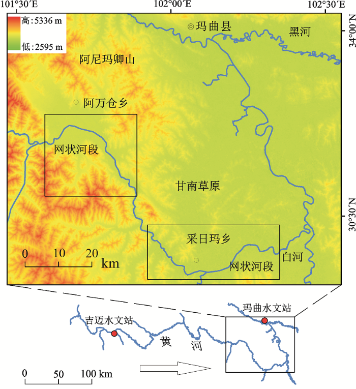
黄河源区的干流流出扎陵湖和鄂陵湖后,沿巴颜喀拉山北侧的河谷地带流向东南方向,在玛曲以上,主要流经山间的平川宽谷,地势较缓,这是黄河源区的第一个冲积河段;在流经久治县的峡谷河段开始进入黄河第一湾的冲积河段(图1)。黄河第一湾地处若尔盖盆地内,行政区划上以甘肃玛曲县境为主,是一段在青藏高原抬升过程中形成的第四纪冲积河段。这里,黄河干流环绕阿尼玛卿山东段,在若尔盖高原由东南流向折向西北流向,干流流向改变了近180°,呈现“U” 型大拐弯,形成著名的黄河第一湾[18]。研究区年降水量520 mm,年均气温2℃,全年无霜期120 d。虽然研究区地壳总体上处于构造抬升区,附近黑河钻孔表明该河段在更新世晚期就开始处于溯源侵蚀状态[19],但这2个网状河段所处地区相对于周边高地来说则处于相对沉降状态,总体表现出主河道略微侵蚀、分支河道及河间湿地明显沉积的特征。
黄河第一湾流出峡谷段后,其入口为甘肃玛曲县阿万仓乡,弯顶中部左岸为玛曲县采日玛乡、右岸为四川若尔盖县唐克乡,出口端为玛曲县城西北侧。黄河第一湾呈现宽阔的河谷平原地貌,主河道左为甘南草原,数条弯曲型支流汇入,右侧是若尔盖草原和沼泽,白河从唐克汇入,黑河从玛曲县城东南汇入。在黄河第一弯270 km的河长上,沿途出现了多种河型,其中阿万仓乡与采日玛乡附近分别发育了网状河型,主河道长度分别为50 km和65 km;2个河段入口端与出口端海拔高度分别为3 514 m和3 475 m,3 464 m和3 430 m;主河道平均比降分别为0.78‰和0.52‰,是青藏高原网状河流研究的理想场所。
本文利用2013年不同月份的landsat 8遥感影像和DEM数据,分析阿万仓乡与采日玛乡附近的网状河段在不同流量下活动河道的数目等参数的变化。共收集到3期遥感影像分别是4月18日,7月23日,8月8日,分辨率均为15 m,全部申请自美国地质调查局并从其网站下载(http://glovis.usgs.gov/),DEM的分辨率为30 m,从地理空间数据云网站下载(http://www.gscloud.cn/)。流量以玛曲站的实测流量为参考,通过水文年鉴[20]查得上述日期所对应的流量分别为176 m3/s,1 610 m3/s,978 m3/s。
网状河是多河道相互连通的河型,但是由于其定义对于水位有依赖性,枯水期河水被限制在河道以内,洪水期河水可以漫过河岸[21];当在低水位时水流可以仅在单个主河道内,从而表现为单河道水流[22],而在极高水位时有可能淹没滩地而使相邻的河道互相连通也表现为单河道。该研究工作中所涉及的3个级别的流量尚不致水流漫滩,故没有将相邻河道混淆为同一个河道的情况发生。本文所说的活动河道是指在给定观测期中一个河道的两头都与其他河道相连通并有流动的水流。
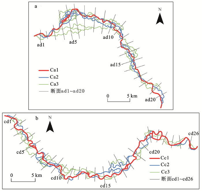
将遥感影像进行5、6、4波段的假彩色合成(这种波段组合可以有效区分陆地和水体,深浅的橙色和绿色是陆地,冰显示为很亮的粉红色,深浅蓝色是水),在ArcGIS10.2中采用线矢量对活动河道进行解译,并使线尽量沿着左右岸线的中间[23]。由于网状河分支河道相互连通的复杂性,加上遥感影像分辨率的限制,有些宽度较小的河道难以识别,为了使图像解译与后面的分析简单化,在固定1:5 000的比例尺下,对于那些平面形态宽度小于3个像元的非活动河道不予勾画,对于那些宽度小于5个像元的心滩和江心洲仍作为河道的一部分。在绘制活动河道时,按照流量从小到大的顺序(176 m3/s、978 m3/s、1 610 m3/s)依次矢量化,即先以4月18日的影像为底图勾画活动河道,所画的活动河道命名为第一类活动河道Ca1和Cc1;再加载8月8日的影像勾画新增加的活动河道,将其命名为第二类活动河道Ca2和Cc2;最后再以7月23日的影像为底图勾画又增加的活动河道,将其命名为第三类活动河道Ca3和Cc3。其中Ca1、Ca2、Ca3是阿万仓乡附近网状河段的活动河道,Cc1、Cc2、Cc3是采日玛乡附近网状河段的活动河道。主河道的确定以Ca1与Cc1为基准,因为这两种河道流路基本都是以单线程为主。当Ca1与Cc2发生分汊时,根据分汊河道的走向与宽度确定主河道。沿垂直网状河道带的方向每隔约2 km设置一个横断面,其中阿万仓乡网状河段共设20个横断面(图2a),采日玛乡网状河段共设26个横断面(图2b)。
图2 阿万仓乡(a)和采日玛乡(b)网状河段河道横断面
Fig. 2 Cross-section locations in the Awancang(a) and Cairima (b) anastomosing channels reaches
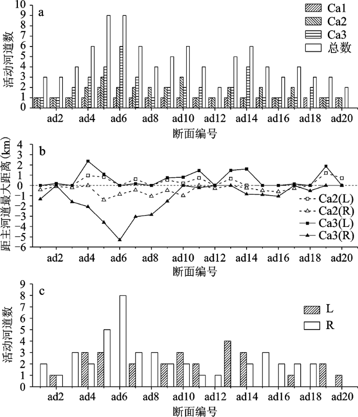
阿万仓网状河段各断面上不同类别的活动河道的数目、Ca2和Ca3型活动河道至主河道Ca1的最大距离,以及主河道两侧活动河道的总数目如图3所示。
图3 阿万仓网状河段各断面不同类别活动河道数(a),各断面上Ca2和Ca3河道距主河道的最大距离(b)及主河道两侧活动河道数(c) L、R分别表示位于主河道左边和右边。
Fig.3 The numbers of different active channels (a), distance between the main channel and the Ca2 or Ca3 channel at each cross-section(b) and the numbers of the active channel(c) of the Awancang anastomosing river reach
2.1.1 各断面活动河道数差异
从图3a上可以明显看出随着流量的增大,断面上活动河道的数目是逐渐增多的,并且所有断面的各类别活动河道的总数都是2个以上,其中断面ad5与ad6的活动河道总数都达到了9个。断面ad1与ad11之间网状河型发育较好,平均每个断面上的活动河道总数为5.4个,是典型的网状河型,平均每个断面上3类活动河道数比值为1:1.67:2.25;断面ad12与ad20之间由于两侧峡谷的限制,平均每个断面上的活动河道总数相对较少为3.6个,但从平面形态上看,认为也是网状河型,平均每个断面上3种类型的活动河道数比值为1:1.22:1.33,这与李志威[18]的研究有所不同,后者把这段河流归类为分汊河型。20个断面平均每个断面3类活动河道数比值为1:1.48:1.86。研究还发现,在流量为176 m3/s的条件下,除了断面ad5出现了2条活动河道,其他断面上都是一条活动河道。
图3b统计了各断面上活动河道Ca2与Ca3在主河道左右两边的最大距离,左边L用正数表示,右边R用负数表示。Ca2(L),Ca2(R),Ca3(L),Ca3(R)的平均值分别为322 m,-398 m,594 m,-1 245 m,其中Ca2(L)与Ca2(R)的绝对值相差较小,而Ca3(L)与Ca3(R)的绝对值相差较大,且都是右边大于左边。在主河道的左边,除了ad20外,折线Ca3(L)要高于折线Ca2(L);在主河道的右边,除了ad2,ad10,ad12,ad17外,折线Ca3(R)要低于折线Ca2(R)。其中ad5,ad6,ad7,ad8上Ca3(R)的值分别为,-3 605 m,-5 317 m,-3 047 m,-2 848 m,距离主河道明显较远。结合图2a可以看出,随着流量的增加,新增的活动河道都是发育在已有活动河道的外侧。
如图3c所示,在20个断面中,ad2、ad9主河道左右两侧活动河道数一样,ad4、ad10、ad11、ad13、ad14、ad19、ad20是左边大于右边,其余的都是右边大于左边。为了使差异具有代表性,选出主河道左右河道数相差大于1的断面。其中左边大于右边的是ad13与ad19,右边大于左边的是ad1、ad3、ad5、ad6、ad8、ad15、ad16、ad18。结合断面图,发现ad1、ad3、ad6、ad8、ad13都处在主河道弯道的顶部,ad15、ad16、ad18、ad19主河道都有一侧紧贴峡谷。进一步观察发现,以上断面发育活动河道较多的方向基本都是在主河道的弯道内侧,即主河道的凸岸方向;ad15、ad16、ad18、ad19由于一侧基岩的限制,活动河道在另一侧较多。其中,从断面ad4~ad8,主河道进入一个大弯道,从东北流向转向东南流向,除断面ad4外,ad5~ad8都是主河道右边活动河道数大于左边活动河道数(ad4主河道左右两边活动河道数分别为3、2,相差甚微)。
2.1.2 各断面活动河道线密度
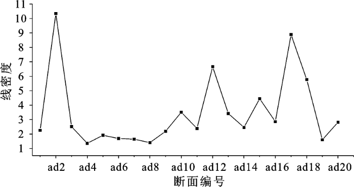
由于各个断面上活动河道数不同,而各活动河道距离主河道的远近也不一样,为了更易于比较,针对每个断面,用其活动河道总数除以网状河道带宽度(断面与网状河道带两个交点之间的距离),得到每个断面上单位距离内的活动河道数,本文称为线密度。线密度越大,表明断面上的活动河道越密集;线密度越小,表明断面上的活动河道越稀疏。阿万仓河段各断面活动河道线密度见表1。
表1 阿万仓网状河段各断面上活动河道的线密度
Table 1 Line densities of the active channels for each cross-section in the Awancang anastomosing river reach
| 断面 | 活动河 道总数 | 距离(km) | 线密度 | 断面 | 活动河 道总数 | 距离(km) | 线密度 |
|---|---|---|---|---|---|---|---|
| ad1 | 3 | 1.33 | 2.26 | ad11 | 4 | 1.68 | 2.38 |
| ad2 | 3 | 0.29 | 10.34 | ad12 | 2 | 0.30 | 6.67 |
| ad3 | 4 | 1.59 | 2.52 | ad13 | 5 | 1.46 | 3.42 |
| ad4 | 6 | 4.43 | 1.35 | ad14 | 6 | 2.44 | 2.46 |
| ad5 | 9 | 4.70 | 1.91 | ad15 | 4 | 0.90 | 4.44 |
| ad6 | 9 | 5.32 | 1.69 | ad16 | 3 | 1.05 | 2.86 |
| ad7 | 6 | 3.66 | 1.64 | ad17 | 4 | 0.45 | 8.89 |
| ad8 | 4 | 2.85 | 1.40 | ad18 | 3 | 0.52 | 5.77 |
| ad9 | 5 | 2.28 | 2.19 | ad19 | 3 | 1.87 | 1.60 |
| ad10 | 6 | 1.71 | 3.51 | ad20 | 2 | 0.71 | 2.82 |
如图4所示,断面ad4~ad9的线密度较小且相差小,在1.35~2.19之间,相差0.84,平均值为1.70。断面ad1~ad3与ad10~ad20的线密度相差较大,在1.60~10.34之间,相差8.74,平均值为4.28。断面ad4~ad9之间是广阔的草甸湿地,网状河的发育较好,断面上活动河道数多,河间地宽,线密度较小;断面ad1~ad3与ad10~ad20之间处于峡谷地带,网状河道分布范围受到限制,断面上活动河道数相对较少,河道之间距离较近,线密度较大。
图4 阿万仓网状河段各断面上活动河道的线密度
Fig.4 Line densities of the active channels along each cross-section in the Awancang anastomosing river reach
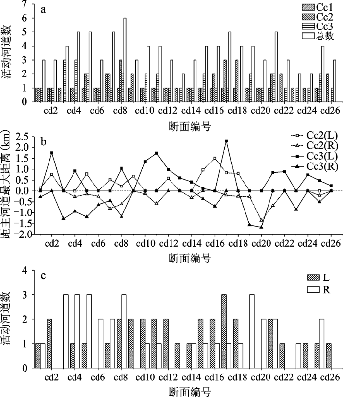
采日玛网状河段各断面上不同类别活动河道的数目、至主河道Cc1的最大距离,以及主河道两侧活动河道的数目如图5所示。
图5 采日玛网状河段各断面上不同类别活动河道数(a)、各断面上Cc2和Cc3河道距主河道的最大距离(b),以及主河道两侧活动河道数(c) L、R分别表示位于主河道左边和右边。
Fig.5 The numbers of different active channels(a), distance between the main channel and the Cc2 or Cc3 channel at each cross-section(b), and the numbers of the active channel(c) located in the left and right side of the main channel for the Cairima anastomosing river reach
2.2.1 各断面活动河道数差异
采日玛网状河段与阿万仓河段一样,随着流量的增大,各断面上活动河道的数目是逐渐增多的,并且所有26个断面的各类活动河道的总数都在2个以上(图5a),其中断面cd8活动河道数最多为6个。平均每个断面上活动河道数为3.7个,与阿万仓乡断面ad12~ad20平均活动河道数相近。cd1~cd9处于峡谷地带,平均每个断面上活动河道数为4.11,3类活动河道数比值为1:1.30:1.40;cd10~cd26处于甘南草原,平均每个断面上活动河道总数为3.47,3类活动河道数比值为1:0.95:1.16。此外,在流量为176 m3/s的条件下,出现两条活动河道的断面相对较多,例如cd7、cd22、cd26。断面的活动河道数大多在3~5个之间,相差不大。
各断面上活动河道Cc2与Cc3在主河道左右两边的最大距离如图5b所示,且分别以正负值相区别。Cc2(L),Cc2(R),Cc3(L),Cc3(R)的平均值分别为301 m,-230 m,556 m,-445 m,其值Cc2(L)与Cc2(R)的绝对值相差较小,而Cc3(L)与Cc3(R)的相差较大,且都是左边大于右边。由于部分断面上只发育了两类活动河道,故这些断面上的Cc2值或Cc3值就会出现0,从而使得4条折线出现一些交点。除了个别断面外,总体上Cc3类活动河道比Cc2类活动河道距离主河道远,在图5b上呈现出Cc3在Cc2折线的外侧。断面cd9~cd14上主河道右侧并没有出现第三类活动河道Cc3,cd19~cd26主河道左侧未出现第二类活动河道。后两类活动河道与主河道最远的距离为2 304 m,远比阿万仓河段的最远距离5 317 m小。
在采日玛河段26个断面中,cd1、cd14、cd21断面上主河道左右两侧的活动河道数一样,在cd2、cd9~cd13、cd15~cd18、cd22、cd24、cd26断面上是主河道左边的多于右边,其余的则是右边的活动河道数多于左边(图5c);同时,在一个断面上主河道一侧的活动河道最多为3个。结合DEM图(图1),发现cd3~cd8河道都处在峡谷地带且河道右侧的河谷更宽阔,cd9~cd18处于甘南草原且位于主河道大弯道的顶部(主河道在此由东南流向转向东北流向),cd19~cd26其实是网状河向弯曲河过度的河段(左侧出现一系列废弃河道遗迹)。同阿万仓网状河段一样,采日玛网状河段各断面上活动河道较多的方向基本都是在主河道的弯道内侧。
2.2.2 各断面活动河道线密度
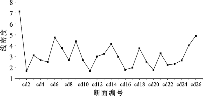
采日玛网状河段各断面上活动河道的线密度见表2。采日玛网状河段26个断面上活动河道的线密度波动变化较大,除了断面cd1的线密度达到了最大值7.14外,其余断面的线密度基本在2~5左右波动(图6)。这里未出现像阿万仓河段那样连续多个断面(ad4~ad9)线密度波动较小的情况,这是因为采日玛网状河段处草原湿地发育相对较窄,使得分支河道发育较短,整个网状河段较为狭长,连续断面的线密度波动较大。断面cd10~cd26的网状河大部分位于甘南草原,平均每个断面的线密度为2.91。结合遥感图像,发现穿越草原湿地且网状河发育较好的断面有cd11、cd16和cd17,但是这3个断面的线密度相对较小,分别为1.72、1.82、2.01,平均值为1.85。
图6 采日玛网状河段各断面上活动河道的线密度
Fig.6 Line densities of the active channels along each cross-section in the Cairima anastomosing river reach
表2 采日玛网状河段各断面上活动河道的线密度
Table 2 Line densities of the active channels for each cross-section in the Cairima anastomosing river reach
| 断面 | 活动河 道总数 | 距离 (km) | 线密度 | 断面 | 活动河道 总数 | 距离 (km) | 线密度 |
|---|---|---|---|---|---|---|---|
| cd1 | 3 | 0.42 | 7.14 | cd14 | 3 | 0.72 | 4.17 |
| cd2 | 3 | 1.76 | 1.70 | cd15 | 4 | 1.33 | 3.01 |
| cd3 | 4 | 1.28 | 3.13 | cd16 | 4 | 2.20 | 1.82 |
| cd4 | 5 | 1.86 | 2.69 | cd17 | 5 | 2.49 | 2.01 |
| cd5 | 5 | 1.97 | 2.54 | cd18 | 4 | 1.06 | 3.77 |
| cd6 | 3 | 0.63 | 4.76 | cd19 | 4 | 1.56 | 2.56 |
| cd7 | 5 | 1.32 | 3.79 | cd20 | 3 | 1.67 | 1.80 |
| cd8 | 6 | 2.22 | 2.70 | cd21 | 5 | 1.51 | 3.31 |
| cd9 | 3 | 0.68 | 4.41 | cd22 | 3 | 1.32 | 2.27 |
| cd10 | 4 | 1.49 | 2.68 | cd23 | 2 | 0.85 | 2.35 |
| cd11 | 4 | 2.32 | 1.72 | cd24 | 2 | 0.75 | 2.67 |
| cd12 | 3 | 0.99 | 3.03 | cd25 | 4 | 0.99 | 4.04 |
| cd13 | 2 | 0.61 | 3.28 | cd26 | 3 | 0.61 | 4.92 |
表3 选取断面的河谷宽度与线密度
Table 3 Valley width and line density for certain cross-sections in the Awancang and Cairima anastomosing river reaches
| 断面编号 | 河谷宽度(km) | 线密度 | 断面编号 | 河谷宽度(km) | 线密度 |
|---|---|---|---|---|---|
| ad5 | 20.0 | 1.91 | ad14 | 6.6 | 2.46 |
| ad6 | 14.5 | 1.69 | ad16 | 1.3 | 2.86 |
| ad7 | 15.6 | 1.64 | cd8 | 2.6 | 2.70 |
| ad8 | 9.0 | 1.40 | cd16 | 13.6 | 1.82 |
| ad9 | 10.0 | 2.19 | cd17 | 11.3 | 2.01 |
| ad11 | 3.9 | 2.38 |
网状河是稳定的多河道河流体系,通过绘制阿万仓与采日玛网状河段不同流量下的活动河道数,发现随着流量的增加活动河道相应增多,其增加方式是由主河道向两侧扩展的。在小流量时期水位低,水流基本限制在主河道内,流路以单河道为主,网状河的活动河道少。随着流量的增加,周边的干河道由于有水流经过而变成活动河道,这些新出现的活动河道基本处在老活动河道的两边;3种类型的活动河道数量基本是递增的,即当流量从176 m3/s增加到978 m3/s(流量增加了802 m3/s)时增加的活动河道数没有当流量从978 m3/s增加到1 610 m3/s(流量增加了632 m3/s)时增加的活动河道数多。这是因为离主河道越远,分支河道越窄浅,同时,这些河道的河床高程相差较小,在流量增大到一定程度后可能都有水流活动,从而可见在大流量时这类活动河道数量较多。
通常所报道的网状河流大都发育在构造沉降背景下的冲积平原上,比降很小,常在0.1‰~0.01‰之间,其边界条件是由粉砂质黏土构成,粘结性强,难以在低能条件下被水流冲刷,这在一定程度上阻止了河道的侧向侵蚀迁移,从而保持了河道的稳定性,这与同样是多河道但极易改道的辫状河流有着明显的区别[22]。黄河青藏高原网状河段形成于构造抬升的背景下,两段主河道比降很大,分别为0.78‰和0.52‰,虽然河床质是砾石,但河岸与河间地的沉积物同样以泥质和粉砂质为主,分支河道弯曲度与宽窄不一,河道总体上都比较稳定,位置已基本固定,侧向迁移不明显[17],几十年来基本没有发生变化。
在黄河青藏高原的阿万仓与采日玛网状河段,主河道都发生了规律的弯曲且具有弯曲河流的特性,在主河道弯道内侧发育的分支河道数要比弯道外侧发育的分支河道数多,这有利于维持网状河流体系的空间均衡性和稳定性。根据以往的研究结果,砂质网状河分支河道的发育是河道的决口冲裂作用引起的[24,25]。王随继[26]提出了网状河的新河道形成的冲裂机制的两种模式:冲裂归一模式和冲裂网化模式,并以长江荆江分流网状河的多河道形成过程进行了论证,1644年之前,长江荆江河段是一条弯曲河流,从1644~1826年的演变过程中,长江主河道和分支河道先后经历了冲裂归一模式与冲裂网化模式,最终形成了稳定的网状形态。此外,国外学者对亚马逊河的研究也发现,中游的网状河型是由单河道的弯曲河型转化而来,在晚更新世时亚马逊河是以弯曲河型为主[27,28]。这两个河段的河床质是砾石及卵石,且主河道比降较大,是不同于砂质网状河型的砾质网状河型,虽然其河道空间分布及其主次河道形态呈现出类似上述两个砂质网状河流的特性,但是,其分支河道的初始形成是否如砂质网状河流一样遵循泛滥平原上的河道化过程[10]这一规律,仍然需要将来进行更多深入细致的分析研究工作。
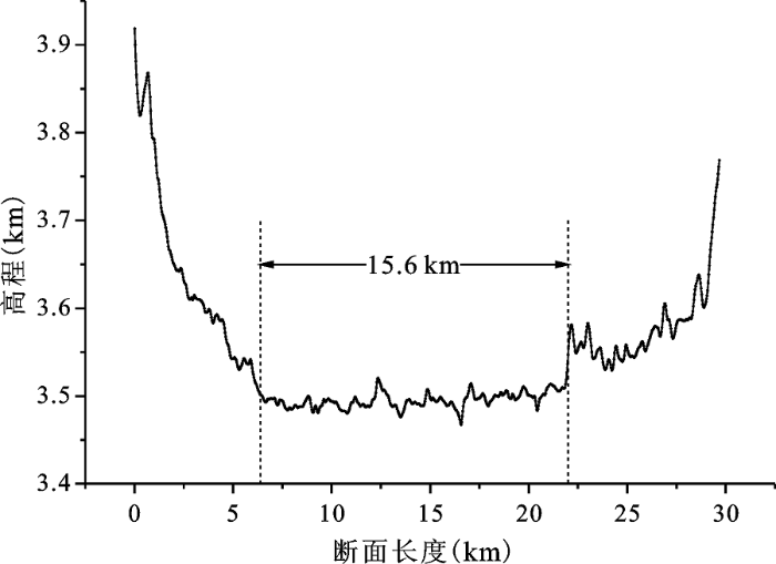
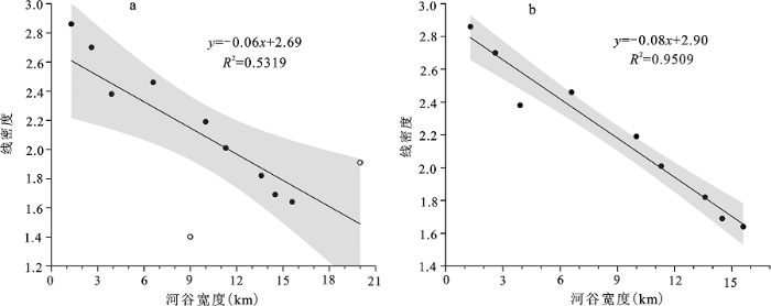
在没有峡谷限制的草原湿地河段,网状河分支河道发育较多且长度也相对较长。这是因为平坦宽阔的地形条件有利于网状河的发育,河间地较宽,相应断面线密度较小。在峡谷限制的河段,由于河谷的宽度受两侧基岩限制较大,短距离内宽窄多变,导致各断面线密度相对较大且变化较大。为了进一步探究网状河的发育情况与其河谷的关系,对断面的线密度与断面对应的河谷宽度进行分析。前面已知阿万仓乡的断面ad5~ad9之间与采日玛乡断面cd16、cd17之间网状河的分支河道发育较好,线密度较小且波动小,因此选取这些断面作为待分析断面。此外,根据图像又选取4个分支河道发育较好且河谷易辨别与测量的断面,ad11、ad14、ad16、cd8,共11个断面。在ArcGIS10.2环境下加载DEM图像,将选取的断面线延长,使其与两侧山地相交,生成剖面图,根据剖面图确定该河谷的宽度。例如图7是断面ad7的剖面图,由图确定的河谷宽度是15.6 km。
图7 断面ad7及其延伸线的地表海拔高程
Fig.7 Surface elevation along the cross-section ad7 and its extension line to both sides
对网状河活动河道线密度与河谷宽度进行了相关分析(图8),发现二者之间呈现很好的线性关系。图8a的相关性(R2=0.531 9)由于2个异常点(ad5、ad8)比图8b的相关性(R2=0.950 9)较弱。观察断面图,发现断面ad5的延长线的左边一部分会穿过支流的河谷,从而有较大误差,而ad8是一个异常值。通过图8的分析可知,在网状河形态发育较好的河段,垂直于网状河道带单位距离内发育的河道数与河谷宽度有极好的线性负相关关系,即随着河谷宽度的增加主河道横向上单位距离内的河道数越少。这是因为宽阔的河谷更有利于网状河的分支河道沿着主河道向两侧展开,河谷越宽阔,网状河的河间地越宽,垂直于主河道的相邻分支河道距离越远。在成熟发育网状河的宽阔泛滥平原地带,根据拟合的公式,我们可以利用网状河横向上河道的线密度大致估算河谷的宽度。
图8 河谷宽度和线密度的回归关系(95%的置信水平) a是11个选定断面的结果,b是剔除断面ad5、ad8(a中空心显示)后的结果
Fig.8 Relationship between the valley width and line density (95% confidence level)
1) 根据流量大小划分出的3种类型活动河道,其分布规律基本是后者位于前者的两侧,据此可以推断,网状河分支河道基本是从主河道向两侧逐渐发展的,但受到地貌因素的影响,两个河段之间仍有差别。对于阿万仓河段,在河谷和河间地相对宽阔处,每个河道断面上3种类型的活动河道数的比值为1:1.67:2.25;而在受到峡谷明显限制的地方,该比值为1:1.22:1.33。在采日玛河段,在受峡谷限制河段和开阔的甘南草原河段,该比值分别为1:1.3:1.4和1:0.95:1.16。
2) 在没有峡谷限制的草原湿地河段,网状河的主河道发生弯曲时,弯道内侧的活动河道总是大于弯道外侧的活动河道,这有利于维持网状河流体系的空间均衡性和稳定性。
3) 宽阔的泛滥平原是网状河流多河道体系得以稳定发育的重要地貌条件,该条件下主河道横向上发育的活动河道较多,但是由于河间地也较宽,导致线密度较小且相差不大。
4) 研究区网状河形态发育较好的河段,线密度与河谷宽度具有极好的线性负相关关系,即随着河谷宽度的增加河道带横向上单位距离内的河道数越少。而峡谷地带由于两侧相对较高的地形的限制,河谷宽窄不一,活动河道的线密度相对较大、且差别也较大。
The authors have declared that no competing interests exist.
| [1] |
River Channel Patterns - Braided, Meandering and Straight [J].
Channel pattern is used to describe the plan view of a reach of river as seen from an airplane, and includes meandering, braiding, or relatively straight channels. Natural channels characteristically exhibit alternating pools or deep reaches and riffles or shallow reaches, regardless of the type of pattern. The length of the pool or distance between riffles in a straight channel equals the straight line distance between successive points of inflection in the wave pattern of a meandering river of the same width. The points of inflection are also shallow points and correspond to riffles in the straight channel. This distance, which is half the wavelength of the meander, varies approximately as a linear function of channel width. In the data we analysed the meander wavelength, or twice the distance between successive riffles, is from 7 to 12 times the channel width. It is concluded that the mechanics which may lead to meandering operate in straight channels. River braiding is characterized by channel division around alluvial islands. The growth of an island begins as the deposition of a central bar which results from sorting and deposition of the coarser fractions of the load which locally cannot be transported. The bar grows downstream and in height by continued deposition on its surface, forcing the water into the flanking channels, which, to carry the flow, deepen and cut laterally into the original banks. Such deepening locally lowers the water surface and the central bar emerges as an island which becomes stabilized by vegetation. Braiding was observed in a small river in a laboratory. Measurements of the adjustments of velocity, depth, width, and slope associated with island development lead to the conclusion that braiding is one of the many patterns which can maintain quasi-equilibrium among discharge, load, and transporting ability. Braiding does not necessarily indicate an excess of total load. Channel cross section and pattern are ultimately controlled by the discharge and load provided by the drainage basin. It is important, therefore, to develop a picture of how the several variables involved in channel shape interact to result in observed channel characteristics. Such a rationale is summarized as follows: Channel width appears to be primarily a function of near-bankfull discharge, in conjunction with the inherent resistance of bed and bank to scour. Excessive width increases the shear on the bed at the expense of that on the bank and the reverse is true for very narrow widths. Because at high stages width adjustment can take place rapidly and with the evacuation or deposition of relatively small volumes of debris, achievement of a relatively stable width at high flow is a primary adjustment to which the further interadjustments between depth, velocity, slope, and roughness tend to accommodate. Channel roughness, to the extent that it is determined by particle size, is an independent factor related to the drainage basin rather than to the channel. Roughness in streams carrying fine material, however, is also a function of the dunes or other characteristics of bed configuration. Where roughness is independently determined as well as discharge and load, these studies indicate that a particular slope is associated with the roughness. At the width determined by the discharge, velocity and depth must be adjusted to satisfy quasi-equilibrium in accord with the particular slope. But if roughness also is variable, depending on the transitory configuration of the bed, then a number of combinations of velocity, depth, and slope will satisfy equilibrium. An increase in load at constant discharge, width, and caliber of load tends to be associated with an increasing slope if the roughness (dune or bed configuration) changes with the load. In the laboratory river an increase of load at constant discharge, width, and caliber resulted in progressive aggradation of long reaches of channel at constant slope. The
|
| [2] |
A classification of alluvial channel systems [J].
The classification can be applied to ancient alluvial deposits through an understanding of the processes that relate channel morphologies to their resulting sedimentary suites. As the processes are imperfectly understood, so the application to paleochannels is imprecise. However, it can be made satisfactorily in most cases, provided maximum use is made of the channel-process information in alluvial sedimentary models.
|
| [3] |
Earth´s Changing Surface. An introduction to Geomorphology [J].https://doi.org/10.1111/1468-0297.0j674 URL [本文引用: 1] 摘要
Abstract The following values have no corresponding Zotero field: ID - 272
|
| [4] |
Sedimentation in anastomosed river systems; examples from alluvial valleys near Banff, Alberta [J].https://doi.org/10.1306/212F7991-2B24-11D7-8648000102C1865D URL [本文引用: 1] 摘要
ABSTRACT 3 anastomosed river systems are described. Each reach consists of an interconnected network of low-slope, narrow and deep, straight to sinuous, stable channels that transport coarse sand and gravel. Channels are separated by levees and wetlands composed of silt/mud and vegetation. Gravel-bed braided channels occur upstream from each anastomosed system, joined by a transitional reach comprising stable, elongate, silt islands within braided channels. The 3 anastomosed reaches have formed upstream from elevating base levels caused by deposition of alluvial fans across trunk valleys. -from Authors
|
| [5] |
Patterns of Alluvial Rivers [J]. |
| [6] |
Anastomosis and the continuum of channel pattern [J].https://doi.org/10.1002/esp.3290180705 URL [本文引用: 1] 摘要
ABSTRACT Anastomosing rivers are characterized by multiple channels separated by islands excised from the floodplain. Their status relative to the continuum concept of channel pattern is assessed with channel pattern defined in terms of three variables - flow strength, bank erodibility and relative sediment supply. Using an ordinal scaling (L(ow)-M(oderate)-H(igh)), the traditional forms of straight, meandering and braided have respective representations of (L,L,L), (M,L/M,L/M) and (H,H,M/H) in terms of those variables. The anastomosing pattern is on average represented by (L,L,M/H) but not so definitively as other forms. Specification of the third element (sediment supply) is particularly hampered by the paucity of data but aggradation, a characteristic of many anastomosing rivers, can be thought of as symptomatic of a moderately high rate of supply relative to the ability for onward transport. A sufficiently high rate of supply to a channel with low flow strength and resistant banks would induce shoaling and/or lateral constriction that locally forces flow out of the main channel and ultimately leads to the cutting of anabranches. A flow regime characterized by concentrated floods of relatively large magnitude is also regarded as highly conducive to the formation of new channels where low bank erodibility constrains channel capacity. Anastomosis may in certain cases represent a transitional form of channel pattern but there is no denying the longevity of some anastomosing systems.
|
| [7] |
Anastomosing rivers: a review of their classification, origin and sedimentary products [J].https://doi.org/10.1016/S0012-8252(00)00038-6 URL [本文引用: 1] 摘要
Anastomosing rivers constitute an important category of multi-channel rivers on alluvial plains. Most often they seem to form under relatively low-energetic conditions near a (local) base level. It appears to be impossible to define anastomosing rivers unambiguously on the basis of channel planform only. Therefore, the following definition, which couples floodplain geomorphology and channel pattern, is proposed in this paper: an anastomosing river is composed of two or more interconnected channels that enclose floodbasins. This definition explicitly excludes the phenomenon of channel splitting by convex-up bar-like forms that characterize braided channels. In present definitions of anastomosing rivers, lateral stability of channels is commonly coupled with their multi-channel character. Here, it is suggested that these two properties be uncoupled. At the scale of channel belts, the terms ‘straight’, ‘meandering’ and ‘braided’ apply, whereas at a larger scale, a river can be called anastomosing if it meets the definition given above. This means that, straight, meandering and braided channels may all be part of an anastomosing river system. Straight channels are defined by a sinuosity index; i.e., the ratio of the distance along the channel and the distance along the channel-belt axis is less than 1.3. They are the type of channel that most commonly occurs in combination with anastomosis. The occurrence of straight channels is favoured by low stream power, basically a product of discharge and gradient, and erosion-resistant banks. Anastomosing rivers are usually formed by avulsions, i.e., flow diversions that cause the formation of new channels on the floodplain. As a product of avulsion, anastomosing rivers essentially form in two ways: (1) by formation of bypasses, while bypassed older channel-belt segments remain active for some period; and (2) by splitting of the diverted avulsive flow, leading to contemporaneous scour of multiple channels on the floodplain. Both genetic types of anastomosis may coexist in one river system, but whereas the first may be a long-lived floodplain-wide phenomenon, the latter only represents a stage in the avulsion process on a restricted part of the floodplain. Long-lived anastomosis is caused by frequent avulsions and/or slow abandonment of old channels. Avulsions are primarily driven by aggradation of the channel belt and/or loss of channel capacity by in-channel deposition. Both processes are favoured by a low floodplain gradient. Also of influence are a number of avulsion triggers such as extreme floods, log and ice jams, and in-channel aeolian dunes. Although some of these triggers are associated with a specific climate, the occurrence of anastomosis is not. A rapid rise of base level is conductive to anastomosis, but is not a necessary condition. Anastomosing rivers can be considered an example of equifinality, since anastomosis may result from different combinations of processes or causes. Anastomosing river deposits have an alluvial architecture characterized by a large proportion of overbank deposits, which encase laterally connected channel sand bodies. Laterally extensive, thick lenses of lithologically heterogeneous, fine-grained avulsion deposits can be an important element of the overbank deposits of anastomosing rivers. These deposits may also fully surround anastomosing channel sandstones. Anastomosing channel sand bodies frequently have ribbon-like geometries and may possess poorly developed upward-fining trends, as well as abrupt flat tops. The overbank deposits commonly comprise abundant crevasse splay deposits and thick natural levee deposits. Lacustrine deposits and coal are common in association with anastomosing river deposits. None of these characteristics is unique to anastomosing river deposits, and in most cases, anastomosis (coexistence of channels) cannot be demonstrated in the stratigraphic record.
|
| [8] |
关于河流分类及成因问题的讨论 [J].On the classification and causes of formation of different channel patterns . |
| [9] |
根据河道形态和沉积物特征的河流新分类 [J].https://doi.org/10.3969/j.issn.1000-0550.1999.02.013 URL Magsci [本文引用: 1] 摘要
目前河流分类方案较多,各有所长和不足,不同学科间的河型表述也有一定的差异,不便于相互沟通。在讨论了分别以侵蚀阶段、沉积物搬运方向、河道和河间地的相对沉积速率以及河道平面形态等为标准的代表性河流分类方案的不足之处后,提出一个新的河型分类,把冲积河流分为辫状河、曲流河、分汊河、网状河和直流河五类,以便于沉积学界、地貌学界和水利学界等能够在统一的河型分类的格架中相互借鉴各自的研究成果。
A new classification of fluvial rivers according to channel planform and sediment characteristics .https://doi.org/10.3969/j.issn.1000-0550.1999.02.013 URL Magsci [本文引用: 1] 摘要
目前河流分类方案较多,各有所长和不足,不同学科间的河型表述也有一定的差异,不便于相互沟通。在讨论了分别以侵蚀阶段、沉积物搬运方向、河道和河间地的相对沉积速率以及河道平面形态等为标准的代表性河流分类方案的不足之处后,提出一个新的河型分类,把冲积河流分为辫状河、曲流河、分汊河、网状河和直流河五类,以便于沉积学界、地貌学界和水利学界等能够在统一的河型分类的格架中相互借鉴各自的研究成果。
|
| [10] |
网状河流和分汊河流的河型归属讨论 [J].Discussion on channel patterins of anastomosing and anabranched rivers . |
| [11] |
Anastomosing river system along the subsiding middle Yangtze River basin, southern China [J].https://doi.org/10.1016/j.catena.2004.11.007 URL Magsci [本文引用: 1] 摘要
The study focuses on the formation processes of the uprivermost (Jingjiang reach) of three anastomosing river reaches along the middle Yangtze River, downstream of the Three Gorges Dam site and 1700 km upriver from the seacoast at Shanghai in southern China. The Jingjiang reach consists of large anastomosing channels: the Songzi, Hudu, Anxiang and Ouchi rivers, which depart from the Yangtze trunk channel and flow southward and southeastward up to 200 km into the Dongting basin and lake; the lake rejoins the Yangtze at Chenglingji. The 7000 km 2 anastomosing reach is characterized by multiple, stable, low gradient channels (0.00004 m/m, 4 cm/km), with low width/depth ratios (<40), low stream powers (<7 W/m 2) with very high sedimentation rates (33.5 123.3 mm/year) in some channels. Tectonic subsidence, caused by the Himalayan Orogeny, is thought to be the primary forcing mechanism in causing the anastomosing channel processes and deposition. Historical documents have shown that the Jingjiang channels were caused by repetitive avulsions southward from the Yangtze channel. The earliest recorded avulsion occurred in a high flood period before 1644, and subsequent avulsions have continued to modify the topography. Three major avulsion channels have diverted 14 33% of the discharge and 17 47% of suspended sediment load from the Yangtze channel. These channels have remained laterally stable, a characteristic of anastomosing rivers due to their low gradient, silt-clay banks, densely vegetated natural levees and stable interchannel islands consisting of clayey-silt that supports dense riparian vegetation. Data derived from hydrological gauging stations over the last 45 years demonstrate that total discharge and sediment load of anastomosing channels has decreased by two thirds, largely due to sediment aggradation on channel beds. Reduced sediment load and discharge, and human-caused channel modification were more pronounced in the eastern channels. With the completion of the 3-Gorges Dam in 2009, the anastomosing channels will cease to carry significant quantities of water and sediment to maintain fluvial vigor. In the next 100 years, the Yangtze main channel may become the only active channel as the anastomosing channels slowly will be infilled.
|
| [12] |
Hydrological processes of an anastomosing river system on the Zhujiang River Delta, China [J].
The interconnected channels of the Xijiang and Beijiang rivers on the Zhujiang River delta and the flood basins surrounded by the channels form an anastomosing river system. The system can be divided into three zones (A, B and C) that are influenced mainly by river current, tidal current or both. To reveal the differences and the similarities between the two rivers and among the three zones in the system, six representative gauging stations were chosen to collect relevant data, such as the stream mean velocity, discharge, width, suspended sediment concentration, water level elevation and the width/depth ratio (W:D). Statistical relationships between these parameters were established. Although the planforms of both rivers on the delta show multiple channels, there are some differences in hydrological processes and channel morphology between the two rivers and among the three zones. The Xijiang channels are more efficient in hydraulic geometry than the Beijiang channels especially in Zone A. In Zone A, the channel W:D of the Beijiang River (about 80) exceeds 40 (the upper limit for an anastomosing river), but the Xijiang River W:D (30.4) is in the range. In zones B and C, the W:D of both rivers is in the range for an anastomosing river pattern. The channel gradient of the Xijiang River is lower than that of the Beijiang. The formation of the anastomosing system, and the differences between the two rivers and among the various channel reaches resulted from river self-adjustment; in this case human activities are not a factor.
|
| [13] |
青藏高原隆起与黄河地文期 [J].
青藏高原隆起与黄河发育历史有密切关系,黄河地文期既反映黄河发育的各个阶段,也与青藏高原隆起的阶段性相对应。根据最近对黄河阶地及地文期的研究,将黄河发育历史划分为三个阶段:1)黄河雏形期,时代为上新世,黄河至少已达到河套地区;2)河湖并存期,早更新世至中更新世,黄河已达到共和盆地,沿黄河及大的支流出现若干湖泊;3)大黄河期,晚更新世至今,沿黄河的湖泊消失,现今黄河的基本面貌形成。
Uplift of the Qinghai-Xizang Plateau and the Yellow River physiographic period .
青藏高原隆起与黄河发育历史有密切关系,黄河地文期既反映黄河发育的各个阶段,也与青藏高原隆起的阶段性相对应。根据最近对黄河阶地及地文期的研究,将黄河发育历史划分为三个阶段:1)黄河雏形期,时代为上新世,黄河至少已达到河套地区;2)河湖并存期,早更新世至中更新世,黄河已达到共和盆地,沿黄河及大的支流出现若干湖泊;3)大黄河期,晚更新世至今,沿黄河的湖泊消失,现今黄河的基本面貌形成。
|
| [14] |
晚新生代黄河上游地貌演化与青藏高原隆起 [J].https://doi.org/10.1360/zd1996-26-4-316 URL [本文引用: 1] 摘要
黄河上游地貌和新生代地层研究表明,30-3.4Ma是一个构造长期稳定,气候炎热和红色盆地广泛发育的时期,形成分布很广的夷平面,即青藏高原的主夷平面,上有风化壳及古岩溶残留。3.4Ma开始,青藏高原整体抬升,主夷平面被分割,解体,盆地中红色碎屑建造强烈变形,开始以扇砾岩为主的内陆磨拉石沉积。
Landform evolution of the upper reaches of Huanghe river in late Cenozoic era and the upwelling of Qinghai-Tibet plateau .https://doi.org/10.1360/zd1996-26-4-316 URL [本文引用: 1] 摘要
黄河上游地貌和新生代地层研究表明,30-3.4Ma是一个构造长期稳定,气候炎热和红色盆地广泛发育的时期,形成分布很广的夷平面,即青藏高原的主夷平面,上有风化壳及古岩溶残留。3.4Ma开始,青藏高原整体抬升,主夷平面被分割,解体,盆地中红色碎屑建造强烈变形,开始以扇砾岩为主的内陆磨拉石沉积。
|
| [15] |
黄河上游的阶地与水系变迁 [J].
The upper reaches of the Huanghe (Yellow) River,a length of 1350 km from Gyaring Lake to Guide county,cuts through the great slope of the northeast part of the Qinghai-Xizang (Tibet) Plateau and it runs through a few of Mesozoic-Cenozoic depositional basins,for example,Guide basin,Gonghe basin,Xinghai basin,Zoige basin,Ngoring-Gyaring basin etc.,the sections between them are a series of gorges of the Huanghe River.Based on author investigation,there is a terrace of 7 steps in the Huanghe River valley by Guide county,a terrace of 3 steps being formed by the ancient Huanghe River and 7 steps in Gonghe basin,6 steps by Gamao Yangqu town,5 steps by Tangnaihai town,Xinghai County,3 steps by Maqu town,Gansu Province,and one step by Ngoring-Gyaring Lake.The overall upper reaches of the Huanghe River was linked up by a series of the stream captures occurred after strongly uplifting of the Qinghai-Xizang area into a plateau.A section of the ancient Huanghe River through the place Gahaitan located on northeastern Gonghe basin towards east into Guide basin was developed during the end of Middle Pleistocene to the middle of the Late Pleistocene,and then it migrated towards southeast to the place Longyangxia Gorge about 60000 years ago.And the gorge from Maqu to Tangnaihai was linked up about 20000 years ago.
On river terraces of the upper reachers of the Huanghe River and change of the river systerm .
The upper reaches of the Huanghe (Yellow) River,a length of 1350 km from Gyaring Lake to Guide county,cuts through the great slope of the northeast part of the Qinghai-Xizang (Tibet) Plateau and it runs through a few of Mesozoic-Cenozoic depositional basins,for example,Guide basin,Gonghe basin,Xinghai basin,Zoige basin,Ngoring-Gyaring basin etc.,the sections between them are a series of gorges of the Huanghe River.Based on author investigation,there is a terrace of 7 steps in the Huanghe River valley by Guide county,a terrace of 3 steps being formed by the ancient Huanghe River and 7 steps in Gonghe basin,6 steps by Gamao Yangqu town,5 steps by Tangnaihai town,Xinghai County,3 steps by Maqu town,Gansu Province,and one step by Ngoring-Gyaring Lake.The overall upper reaches of the Huanghe River was linked up by a series of the stream captures occurred after strongly uplifting of the Qinghai-Xizang area into a plateau.A section of the ancient Huanghe River through the place Gahaitan located on northeastern Gonghe basin towards east into Guide basin was developed during the end of Middle Pleistocene to the middle of the Late Pleistocene,and then it migrated towards southeast to the place Longyangxia Gorge about 60000 years ago.And the gorge from Maqu to Tangnaihai was linked up about 20000 years ago.
|
| [16] |
黄河上游第四纪河流地貌演化——兼论青藏高原1:25万新生代地质填图地貌演化调查 [J].Geomorphological evolution of Quaternary river from upper Yellow River and geomorphological evolution investigation for 1:250000 scale geological mapping in Qinghai-Tibet Plateau . |
| [17] |
黄河流域河型转化现象初探 [J].https://doi.org/10.11820/dlkxjz.2008.02.002 URL Magsci [本文引用: 3] 摘要
<p>黄河以其高含沙水流以及下游河道的高沉积速率而著称于世。迄今的研究, 主要针对黄河中下游流域的 侵蚀、水文泥沙和河床演变方面的研究, 而对黄河流域主支流发生河型转化的现象关注不够。在黄河的不同河段, 河型的变化频繁, 类型多样, 现象复杂, 是研究者不可回避的科学问题。本文选取黄河上游第一弯的玛曲河段、黄河 上游末段托克托附近河段及黄河下游高村上下河段来研究河型转化的形式及影响因素。玛曲河段沿流向发生网状 河型→弯曲河型→辫状河型的转化现象, 该系列转化呈现出由极稳定河型向极不稳定河型的转化, 这与世界上通 常可以观察到的沿流向不稳定河型向稳定河型转化的情况完全相反。这主要受到地壳的抬升、上下峡谷卡口、水动 力特征、边界沉积物特征及植被的区域分布等因素的控制。托克托附近沿流向发生了弯曲河型→顺直河型转化的 现象, 这是较稳定河型向极稳定河型的转化, 主要受到边界沉积物、水动力等因素的控制。高村上下河段沿流向发 生的辫状河型→弯曲河型转化的现象, 是由极不稳定河型向较稳定河型转化的现象, 河道边界沉积物及水动力是 其主要控制因素, 人工大堤只是限制了河道摆动的最大幅度, 对河型的性质影响不大, 但其上游河段修筑的水库导 致下泻的水流在辫状河段的侵蚀能力增强而使其边界沉积物粗化, 并将泥质物大量沉积在弯曲河段, 客观上促进 了河型的转化。</p>
Analysis of river pattern transformations in the Yellow River basin .https://doi.org/10.11820/dlkxjz.2008.02.002 URL Magsci [本文引用: 3] 摘要
<p>黄河以其高含沙水流以及下游河道的高沉积速率而著称于世。迄今的研究, 主要针对黄河中下游流域的 侵蚀、水文泥沙和河床演变方面的研究, 而对黄河流域主支流发生河型转化的现象关注不够。在黄河的不同河段, 河型的变化频繁, 类型多样, 现象复杂, 是研究者不可回避的科学问题。本文选取黄河上游第一弯的玛曲河段、黄河 上游末段托克托附近河段及黄河下游高村上下河段来研究河型转化的形式及影响因素。玛曲河段沿流向发生网状 河型→弯曲河型→辫状河型的转化现象, 该系列转化呈现出由极稳定河型向极不稳定河型的转化, 这与世界上通 常可以观察到的沿流向不稳定河型向稳定河型转化的情况完全相反。这主要受到地壳的抬升、上下峡谷卡口、水动 力特征、边界沉积物特征及植被的区域分布等因素的控制。托克托附近沿流向发生了弯曲河型→顺直河型转化的 现象, 这是较稳定河型向极稳定河型的转化, 主要受到边界沉积物、水动力等因素的控制。高村上下河段沿流向发 生的辫状河型→弯曲河型转化的现象, 是由极不稳定河型向较稳定河型转化的现象, 河道边界沉积物及水动力是 其主要控制因素, 人工大堤只是限制了河道摆动的最大幅度, 对河型的性质影响不大, 但其上游河段修筑的水库导 致下泻的水流在辫状河段的侵蚀能力增强而使其边界沉积物粗化, 并将泥质物大量沉积在弯曲河段, 客观上促进 了河型的转化。</p>
|
| [18] |
黄河源玛曲河段河型沿程变化及其原因 [J].River pattern transition and its causes along Maqu reach of Yellow River source region . |
| [19] |
黄河袭夺若尔盖古湖时代的沉积学依据 [J].https://doi.org/10.1007/BF02006258 URL Magsci [本文引用: 1] 摘要
正若尔盖盆地位于川西北,是伴随青藏高原隆起而形成的断陷盆地.海拔高程3400~3600m,地势南高北低起伏较小.现代黄河从西部流入盆地蜿蜒曲折,在接纳源于东南部山区的白河、黑河后折向西北,从玛曲县流出盆地进入峡谷区.研究峡谷区即为古黄河袭夺区,袭夺前的若尔盖盆地曾长期维持湖泊环境.作者于1992年在若尔盖县黑河牧场西南约3km的黑
Sedimentology evidence of the date of Ruoergai ancinent lake captured by Yellow River .https://doi.org/10.1007/BF02006258 URL Magsci [本文引用: 1] 摘要
正若尔盖盆地位于川西北,是伴随青藏高原隆起而形成的断陷盆地.海拔高程3400~3600m,地势南高北低起伏较小.现代黄河从西部流入盆地蜿蜒曲折,在接纳源于东南部山区的白河、黑河后折向西北,从玛曲县流出盆地进入峡谷区.研究峡谷区即为古黄河袭夺区,袭夺前的若尔盖盆地曾长期维持湖泊环境.作者于1992年在若尔盖县黑河牧场西南约3km的黑
|
| [20] |
|
| [21] |
网状河流体系的基本特征及其影响因素 [J].
网状河流近年来受到较多关注,无论从沉积特征还是从地貌及水力学特征看,网状河流都是一种典型的河型,但目前对网状河流的认识还存在一定的局限性。从沉积特征、地貌及沉积微环境特征及形成条件等方面对网状河流进行了系统的论述和总结。
Basic characteristics and controlling factors of anastomosing fluvial systerms .
网状河流近年来受到较多关注,无论从沉积特征还是从地貌及水力学特征看,网状河流都是一种典型的河型,但目前对网状河流的认识还存在一定的局限性。从沉积特征、地貌及沉积微环境特征及形成条件等方面对网状河流进行了系统的论述和总结。
|
| [22] |
网状河流研究进展述评 [J].https://doi.org/10.11820/dlkxjz.2002.05.005 URL Magsci [本文引用: 2] 摘要
Anastomosing river, as a new fluvial river pattern, has attracted more and more attention of geomorphologists, hydraulic engineers and sedimentologists. Research on anastomosing river is in great demand of the geomorphology, hydraulic engineering and sedimentology. In this paper, after introduction of the basic concept of anastomosing river, the channel plantform and boundary condition, sedimentary characteristics, hydraulic condition of this river pattern are reviewed based on comprehensive references. Furthermore, in the same fluvial system the spatial transformation between anastomosing and another river patterns is also discussed. Some weaknesses and aspects needing more attention on study of anastomosing river are pointed out. These aspects are mainly following. (a) The dynamical mechanism of the avulsion for anastomosing river formation has not studied clearly till now. It needs theoretical explanation and simulation in laboratory or digital model. Obviously, there have some difficulties. (b) The hydraulic dynamics of anastomosing rivers are still unclear because few study has been actualized on fluvial dynamics for multiple channel rivers, especially for anastomosing rivers. Besides, the hydraulic characteristics have some differences between multiple channels. The explanation to every channel of an anastomosing river system is not the same always. The stream power (including gross stream power and specific stream power) is also different between different channels of an anastomosing river system. (c) The scatter values of channel slope and bankfull discharge for anastomosing rivers have not a clear law. One of the causes is that the river number studied fully by researchers is few and distributed in different climate zones. This demands researchers to study much more anastomosing rivers.
The prograss in the research of anastomosing river .https://doi.org/10.11820/dlkxjz.2002.05.005 URL Magsci [本文引用: 2] 摘要
Anastomosing river, as a new fluvial river pattern, has attracted more and more attention of geomorphologists, hydraulic engineers and sedimentologists. Research on anastomosing river is in great demand of the geomorphology, hydraulic engineering and sedimentology. In this paper, after introduction of the basic concept of anastomosing river, the channel plantform and boundary condition, sedimentary characteristics, hydraulic condition of this river pattern are reviewed based on comprehensive references. Furthermore, in the same fluvial system the spatial transformation between anastomosing and another river patterns is also discussed. Some weaknesses and aspects needing more attention on study of anastomosing river are pointed out. These aspects are mainly following. (a) The dynamical mechanism of the avulsion for anastomosing river formation has not studied clearly till now. It needs theoretical explanation and simulation in laboratory or digital model. Obviously, there have some difficulties. (b) The hydraulic dynamics of anastomosing rivers are still unclear because few study has been actualized on fluvial dynamics for multiple channel rivers, especially for anastomosing rivers. Besides, the hydraulic characteristics have some differences between multiple channels. The explanation to every channel of an anastomosing river system is not the same always. The stream power (including gross stream power and specific stream power) is also different between different channels of an anastomosing river system. (c) The scatter values of channel slope and bankfull discharge for anastomosing rivers have not a clear law. One of the causes is that the river number studied fully by researchers is few and distributed in different climate zones. This demands researchers to study much more anastomosing rivers.
|
| [23] |
Planform channel dynamics of the lower Colorado River: 1976-2000 [J].https://doi.org/10.1016/j.geomorph.2004.12.002 URL [本文引用: 1] 摘要
In the past two decades, major flood events have occurred on the lower Colorado River, a dramatic shift from the low flows and moderate floods associated with prior decades of river regulation. This study uses repeat aerial photography and Geographic Information System analysis to examine the planform channel response of the upper Colorado River delta (limitrophe reach) to this recently altered hydrology. Results indicate that channel contraction has been the dominant planform process in recent decades, but periodic floods resulted in channel expansion (1981–1988; 1997–2000) or likely reduced the channel contraction measured between successive aerial photographs (1976–1981; 1988–1994). Sinuosity adjustments were limited during the timeframe of the study (range: 1.31 to 1.38), but the channel did respond with large adjustments in channel width (range: 44 m to 355 m) and changes in total mid-channel bar area (range: 0 to 52.3 ha). A channel probability model developed for this study provides a raster image of the channel changes and depicts areas modified to varying degrees by flood flows. This historical study provides insight into how floods affect the channel system that provides the foundation for aquatic and riparian biodiversity. This issue is of increasing relevance given growing international interest in rehabilitating the riparian and aquatic ecosystems of the Colorado River delta through intentional flood flows.
|
| [24] |
Anatomy of an avulsion [J]. |
| [25] |
Avulsion mechanisms on the Okavango fan, Botswana: the control of a fluvial system by vegetation [J].https://doi.org/10.1111/j.1365-3091.1992.tb02153.x URL [本文引用: 1] 摘要
ABSTRACT A study of the avulsion of a major distributory channel on the alluvial fan (22 000 km 2 in area) of the Okavango River in northern Botswana has revealed that channels serve as arterial systems distributing water which sustains large areas of permanent swamp. The channels are vegetatively confined. A primary channel, defined here as a channel which receives water and sediment directly from the fan apex, aggrades vertically as a result of bedload deposition. The rate of aggradation increases downchannel and may exceed 5 cm yr 1 in the distal reaches. Rapid aggradation is associated with a decline in flow velocity. This initiates a series of feedback mechanisms involving invasion of the channel by aquatic plants which trap floating plant debris, further reducing flow rate and causing the channel water surface to become elevated, thereby increasing rate of water loss from the channel, accelerating blockage and aggradation. The channel ultimately fails. Enhanced water loss from the channel promotes the growth of flanking swamp vegetation, which confines the failing channel. Increased flow through the swamp erodes pre-existing hippopotamus trails, producing a secondary channel system which overlaps but does not connect directly to the failing reach of the primary channel. The region of failure of the primary channel migrates upstream, accompanied by headward propagation of the secondary channel system. The swamp distal to the failed primary channel dessicates and is destroyed by peat fires. Secondary channels are stable and not prone to blockage. Comparison with avulsions described in other river systems indicates that the influence of plants in the Okavango River system is exceptionally strong.
|
| [26] |
两类多河道河流的形成模式及河道稳定性比较 [J].https://doi.org/10.3321/j.issn:1006-3021.2002.01.016 URL [本文引用: 1] 摘要
在多河道河流中,网状河流作为有别于分汊河流和辫状河流的河型而 提出已经引起人们的注意,但它与分汊河流的区别常常被忽略。为了阐明二者的根本差别,力求从多河道形成模式上对二者进行比较研究。通过对长江下游分汊河流 及荆江网状河流特定河段形成历史及方式的探索,提出河道内的江心洲化模式和河漫滩上的河道化模式分别是分汊河流和网状河流形成的基本途径。由此而决定了网 状河道具有较分汊河流更高的稳定性。
Comparision of formation model and channel stability between two different sorts of mutiple channel river patterns .https://doi.org/10.3321/j.issn:1006-3021.2002.01.016 URL [本文引用: 1] 摘要
在多河道河流中,网状河流作为有别于分汊河流和辫状河流的河型而 提出已经引起人们的注意,但它与分汊河流的区别常常被忽略。为了阐明二者的根本差别,力求从多河道形成模式上对二者进行比较研究。通过对长江下游分汊河流 及荆江网状河流特定河段形成历史及方式的探索,提出河道内的江心洲化模式和河漫滩上的河道化模式分别是分汊河流和网状河流形成的基本途径。由此而决定了网 状河道具有较分汊河流更高的稳定性。
|
| [27] |
The anastomosing pattern and the extensively distributed scroll bars in the middle Amazon River [J].https://doi.org/10.1002/esp.3249 URL Magsci [本文引用: 1] 摘要
Abstract The middle Amazon River, between the confluences of the Negro and Madeira Rivers in Brazil, shows an anastomosing morphology with relatively stable, multiple interconnected channels that locally enclose floodbasins. Additionally, this system is characterized by sinuous secondary channels with meander development, discontinuous natural levees concentrated on the concave banks and extensively distributed scroll bars mainly in the islands, related to subrecent and present‐day migration of mainly secondary channels. This distinguishes the Amazon from many other anastomosing rivers that have laterally stable, non‐meandering channels. We analyzed sedimentary processes using field data, morphology and channel changes trough a temporal analysis using remote sensing data and obtained optically stimulated luminescence (OSL) dating to understand the genesis of this large anastomosing river and the development of its meandering secondary channels. Scroll bars have developed in a multichannel river system at least since 7.5 ± 0.85 ka. Avulsion is inferred to have played a minor role in the formation of this anastomosing system, with only one documented case while mid‐channel bar formation and chute cut‐offs of the main and secondary channels are the main formative mechanisms of anastomosis in this system. Differences in resistance to erosion control the relatively straight main channel and allow secondary channels to develop a meandering platform. Vegetation contributes to the relative stability of islands and the floodplain. Low gradient and high average aggradation rate (1.1 mm yr611) are conditions which favor the development of anastomosis. Additionally, stable external conditions, low abandonment rate of older channels and independence from high avulsion frequency suggest a long‐lived, semi‐static type of anastomosing river in this reach of the Amazon. Copyright 08 2012 John Wiley & Sons, Ltd.
|
| [28] |
OSL age determinations of Pleistocene fluvial deposits in Central Amazonia [J].https://doi.org/10.1590/S0001-37652010000300017 URL [本文引用: 1] 摘要
Absolute dating methods have been used in chronological studies of geological processes and sedimentary units of Quaternary age in Central Amazonia, Brazil. Although radiocarbon dating has been very useful in archaeological research and soil studies, the temporal interval of this method is inefficient in evaluating the sedimentation aspects and geological events from the beginning of the Quaternary in the Amazon basin. The use of crystal luminescence dating has been one of the most promising tool for determining the absolute dating of Quaternary deposits in the Amazonian region. Optically stimulated luminescence (OSL) dating, following the MAR and SAR protocols, in a tectonic-sedimentary study of Quaternary fluvial deposits in the confluence area of the Negro and Solim01es rivers, indicated ages from 1.3 (Holocene) to about 67.4 kyears (Late Pleistocene) for these sediments. Low radioactive isotope concentrations were found about 2ppm for 235U and 238U; 5ppm for 232Th; and the 40K concentrations were almost zero. A comparison was made between MAR and SAR protocols taking into account the fluvial depositional process.brMétodos de data0400o absoluta têm sido usados em estudos cronológicos de processos geológicos e unidades sedimentares de idade quaternária na Amaz00nia Central, Brasil. Embora as data0401es pelo 14C tenham sido muito úteis na pesquisa arqueológica e estudos de solos, o intervalo de tempo abrangido por este método é ineficiente para avaliar aspectos da sedimenta0400o e eventos geológicos do início do Quaternário na bacia Amaz00nica. O uso da data0400o por luminescência de cristais tem sido uma das ferramentas mais promissoras para a determina0400o da idade absoluta de depósitos quaternários na regi00o amaz00nica. A data0400o por luminescência opticamente estimulada (LOE), seguindo os protocolos MAR e SAR, em um estudo tectono-sedimentar de depósitos aluviais quaternários da área de confluência dos rios Negro e Solim01es, indicou idades de 1,3 (Holoceno) até aproximadamente 67,4 ka (Pleistoceno tardio) para estes sedimentos. Baixas concentra0401es de isótopos radioativos foram encontradas, com cerca de 2ppm para 235U e 238U, 5ppm para 232Th e próximas a zero para 40K. Uma compara0400o é feita entre os protocolos MAR e SAR considerando-se os processos deposicionais fluviais envolvidos.
|

/
| 〈 |
|
〉 |