袁钰莹
北京大学城市与环境学院, 北京 100871
Yuan Yuying
中图分类号: K901.6
文献标识码: A
文章编号: 1000-0690(2018)05-0773-07
收稿日期: 2017-04-12
修回日期: 2017-06-21
网络出版日期: 2018-05-10
版权声明: 2018 《地理科学》编辑部 本文是开放获取期刊文献,在以下情况下可以自由使用:学术研究、学术交流、科研教学等,但不允许用于商业目的.
基金资助:
作者简介:
作者简介:袁钰莹(1993-),女,陕西三原人,博士研究生,主要从事中国历史地理研究。E-mail: yuanyuyingscholar@163.com
展开
摘要
全新世大暖期结束后的干冷气候事件和环境恶化使西辽河流域及比邻地区的聚落向南移动集中并推动了原始农业的发展和之后畜牧业对原始农业的取代。各文化的聚落均对河流依赖性较强,主要分布在距河6 km以内地区,6 km以外的聚落多分布在与河流地势上相连的沟谷缓坡且主要集中在老哈河、教来河至大凌河流域,水文分析表明这些沟谷很可能在暖湿期形成过支流或季节河。聚落主要分布在海拔400~700 m的平原丘陵交互区,分布海拔和地形因气候波动和经济生活方式不同而有所变化。
关键词:
Abstract
This study analyses the spatial distribution characteristics of settlement sites, distributing in the West Liaohe River Basin and the neighboring Dalinghe River Basin, as well as the Luanhe River Basin between 9.5-2.3 ka B.P.. The settlement sites belong to a sequence of prehistoric culture, including Xiaohexi, Xinglongwa, Zhaobaogou, Fuhe, Hongshan, Xiaoheyan, Lower Xiajiadian and Upper Xiajiadian cultures. Based on the basic information of settlement sites, collected from the results of the national systematic archaeological field surveys, spatial distribution map of sites was drawn with GIS. Minimum distances from sites to rivers and altitudes were extracted with corresponding Box-whisker charts to present their statistical characteristics visually. Three main conclusions are concluded and deduced. Firstly, temperature, precipitation and vegetation changes caused by climate change influenced prehistoric culture development and subsistence strategies extensively. The drier and colder environmental condition since 6.0 ka B.P. promoted the development of primitive agriculture. The number of sites reached peak in Lower Xiajiadian culture which developed in a relatively warm and humid period. Temperature and precipitation dropped violently around 3.0 ka B.P., resulting that primitive agriculture was replaced by pasture. Secondly, prehistoric settlements depended largely on rivers, especially during dry and cold period. About 50% sites have the minimum site-river distances that are less than 6 km. Sites with the minimum distances of more than 6 km mainly distributed along gullies spreading to or from main rivers, especially in the area enclosed by the Laohahe River, the Jiaolaihe River and the Dalinghe River. Hydrological analysis and fieldwork prove: it is likely that these gullies were branches of rivers or seasonal rivers when it was warm and humid. Thirdly, settlements mainly distributed on the transition area (400-700 m) of plains and hills, which abounded in animal and plant resources. Settlements moved to lower altitude when it was colder and drier. Pasture, which was more resilient to hostile environment, made it possible for more Upper Xiajiadian settlements to distribute along rivers in higher mountainous areas.
Keywords:
由于史前时期文化发展程度有限,聚落地址的选择和文化发展主要受到自然环境的影响,因此,占据着特定时间和空间范围、作为人类居住生活场所的聚落,基于生活方式、所处时期和地区环境的不同,其环境选择和空间分布表现出的不同特点一定程度上反映着人口和文化的空间过程,分析其规律和成因,有助于研究气候和文化经济生活方式的变化及当时局部地区的环境条件。学界近年来已有许多基于考古调查和环境分析,利用地理信息系统(GIS)、计量、聚类等算法,以聚落为基础,研究史前文化演替、聚落形态、空间分布、环境变化和人地关系的探索[1,2,3,4]。西辽河流域及比邻地区受东亚季风影响,对气候变化敏感,在全新世中期发展出小河西至夏家店上层一系列文化,是研究史前时期气候变化背景下人地关系和环境变化较为典型的地区。以往相关研究主要关注对特定文化、聚落遗址,或西辽河流域局部地区的分析,鲜有对整个文化序列全部聚落空间分布的研究[5,6]。本文以该文化序列全国第二次文物普查登记的全部聚落遗址为分析样本,分析总结聚落的空间分布及演化规律,并结合气候环境资料和地形特点,探讨其成因。
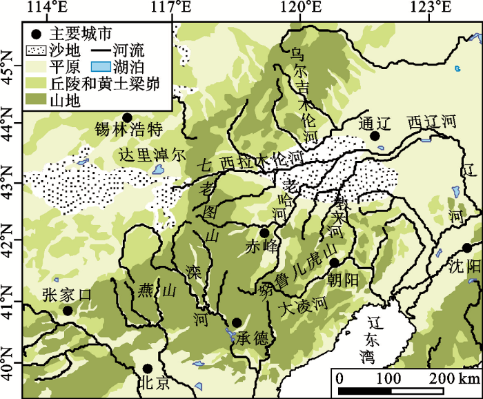
本文研究区域以西辽河流域为中心,包括比邻的大凌河和滦河流域。本区地处东亚季风边缘,冬季干冷,夏季湿热,年均温从北至南0~9℃不等,降水集中在6~8月,自西、北部(年均降水约150~400 mm)向东、南部(年均降水约450~650 mm)递增。地势整体上西高东低,以燕山、七老图山和努鲁儿虎山为间隔,东部以平原为主,有西辽河、西拉木伦河、老哈河、教来河、大凌河等河流,西部则平原、丘陵、沙地、黄土梁峁交错,少有河流分布(图1)。季风的影响和复杂多样的地貌类型,使环境对气候变化的反应更加复杂。较干旱的西北部地区以草原植被为主、更适宜畜牧业,水资源供给更稳定的东南部平原区则能够支持农业的发展,本地区史前文化的发展和演替很大程度上受到这种环境特点的影响[7,8]。从《中国文物地图集》[9,10,11,12]中提取的相关文化聚落遗址数量、文化的主要存在时间和经济生活方式总结如表1(若一个遗址存在两种及以上的文化类型,则将其分别计入相应文化),魏营子文化虽然也分布于此,但目前发现的遗址数量极少且考古研究成果较为有限,故本文暂不讨论。
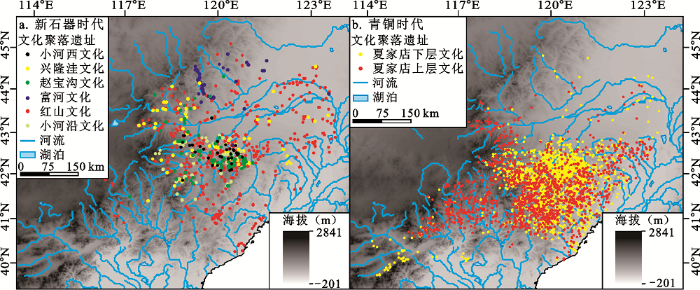
利用GIS画出聚落遗址的空间分布图(图2),新石器时代早期的小河西、兴隆洼和赵宝沟文化,聚落遗址数量较少,绝大多数分布在平原到丘陵的交互过渡地带,主要集中在老哈河、教来河流域,部分遗址分布在西拉木伦河流域,富河文化则沿乌尔吉木伦河分布于两岸的山地丘陵区。其后红山文化的聚落遗址大量增加,分布边缘扩大到西辽河、大凌河地区的平原丘陵地带,但老哈河、教来河流域仍是集中分布区,极少数分布在七老图山和努鲁儿虎山的山地区域。新石器时代末期小河沿文化聚落遗址数量和分布范围骤减后,青铜时代的夏家店下层文化聚落遗址数量达到新高峰,并集中分布在更南部的老哈河至大凌河流域,小部分向西扩散至滦河流域,仍主要分布于平原丘陵带。夏家店上层文化聚落遗址再次减少,大凌河流域的分布密度有所降低,更多聚落遗址沿河向东西方向扩散,分布在滦河和辽河支流流域地区,尤其是努鲁儿虎山至燕山一带的丘陵山地带。从新石器时代到青铜时代,聚落遗址表现出向南移动集中的趋势并主要集中在平原丘陵交互过渡地带,直至夏家店上层文化阶段才有较多聚落分布在山地区。
图2 西辽河流域及比邻地区史前聚落遗址空间分布
Fig. 2 Spatial distribution of prehistoric settlement sites in the West Liaohe River Basin and neighboring region
表1 各考古文化遗址数、主要存在时间和经济生活方式
Table 1 Number of sites, main existence time and subsistence strategy of each archaeological culture
| 文化 | 遗址数(个) | 主要存在时间(ka B.P.) | 经济生活方式 | |
|---|---|---|---|---|
| 新石器时代 | 小河西文化 | 37 | 9.5~8.4 | 渔猎采集 |
| 兴隆洼文化 | 127 | 8.4~7.0 | 渔猎采集为主,出现原始农业 | |
| 赵宝沟文化 | 99 | 7.2~6.2 | 渔猎采集为主,原始农业比重略有增加 | |
| 富河文化 | 44 | 7.5~5.0 | 渔猎采集为主 | |
| 红山文化 | 994 | 6.5~5.0 | 早期渔猎采集为主,后期原始农业为主 | |
| 小河沿文化 | 80 | 5.0~4.0 | 原始农业和渔猎采集并存的混合经济 | |
| 青铜时代 | 夏家店下层文化 | 5323 | 4.0~3.0 | 原始农业为主,渔猎采集为辅 |
| 夏家店上层文化 | 1880 | 3.0~2.3 | 畜牧业、原始农业和渔猎采集兼有的半农半牧混合经济 |
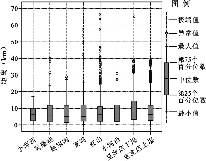
受制于技术水平和研究地区降水的季节性差异,河流对史前时期人类活动和聚落选址、迁移具有非常重要的影响。利用GIS计算各遗址到区域内主要河流的最短距离,按文化分类统计画出箱图(图3)以反映其统计特征。各文化均有近50%的聚落分布在距河流6 km以内的区域,超过75%分布在距河15 km以内的区域,表明各文化聚落对河流始终依赖性较强。6.5 ka B.P.和4.0 ka B.P.前后西拉木伦河水系有两次强烈下切、形成了两级阶地,河流摆动使河谷中河漫滩十分发育[13],阶地与河漫滩为人类提供了合适的居住场所。少数聚落仅距河流数10 m,小于预防水位上涨导致的灾害的安全距离,这可能是后来河流动态发育中河道摆动、侵蚀河岸所致。从小河西到红山再到夏家店上层文化,聚落遗址到河流的最近距离整体上两次表现出先增后减的特征,最早期的小河西文化聚落遗址整体上距河流最近,处于渔猎采集和原始农业转变期的红山文化次之,而遗址数量最多、以原始农业为主的夏家店下层文化则最远。
图3 各文化聚落遗址至河流最近距离
Fig. 3 Box-whisker chart of minimum distances from sites to rivers
根据图2,大部分离河流较远的聚落遗址分布在与主要河流在地势上延伸相连的沟谷缓坡地带,由于同种生活方式的聚落对居址环境的选择具有相似性且本地区聚落对河流依赖度高,因此这些沟谷地带很有可能是气候暖湿、河流水量充足、地下水位高时形成的支流或季节河。地区中南部的老哈河、教来河和大凌河形成了一个近似封闭的圈,其中心是东北-西南向的努鲁儿虎山,这里聚落遗址分布密集,而且与河流最近距离大于6 km的遗址主要分布于此,尤以夏家店下层文化为多,这是造成该文化整体上聚落遗址至河流最短距离最大的主要原因。高程地形图显示一系列沟谷从努鲁儿虎山向四周河流延伸,遗址主要分布在两边的缓坡阶地。据实地考察,这一地区确有许多冲沟发育,既有近期形成的,也有部分表现出古河道的河床相沉积特征,部分还具有多层河床相沉积,表明随着河流的发育摆动,该处曾多次形成过河道。大部分冲沟已经完全干涸,少部分至今仍在雨水丰沛时形成季节河。用GIS对努鲁儿虎山地区进行水文分析得到其河网(图4),结果显示各主要河流两侧均有许多河网发育并顺地势向四周延伸,距河流较远的遗址主要分布在离这些支流较近的地方。例如赵宝沟遗址(图4中A点)的发掘证明以蚌为主的河生动物是其日常食物重要组成部分[14],遗址距最近的河流12 km,超出原始经济中采集者5 km和狩猎者10 km的活动半径[15],因此遗址附近一定有供给日常生活的水源。河网分析显示遗址南部和北部均可能有支流存在,实地调查证实遗址西南有一条通向教来河的泉水沟,常年流水不断,为聚落提供了良好的生存环境[14]。小山遗址和牛河梁遗址(图4中B点、C点)等也有类似情况。综上,老哈河、教来河和大凌河环绕的地区当时应有许多支流、水沟和季节河,地下水含量和地表径流比其他地区更丰富,使得大量距离河流较远、尤其是以原始农业为主的聚落集聚于此成为可能。
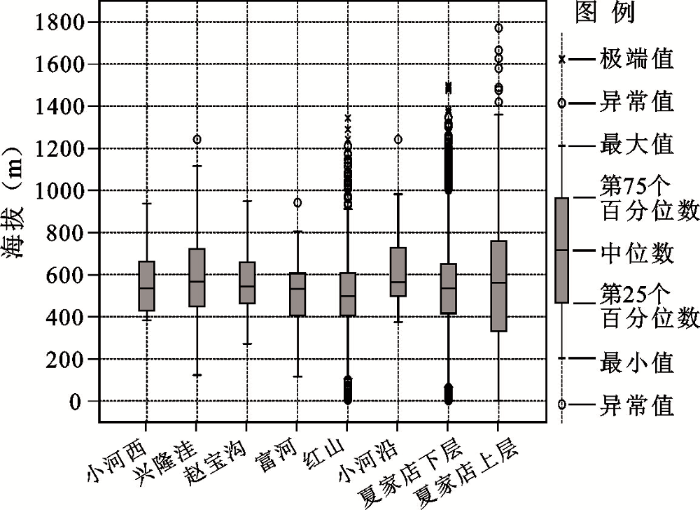
利用GIS提取各聚落遗址的海拔并按文化分类统计画出箱图(图5)。各文化均有75%以上的聚落遗址分布在海拔800 m以下的地区,除夏家店上层文化外,各文化均有超过50%的聚落分布在400~700 m海拔区。从小河西到兴隆洼文化,聚落遗址海拔分布范围扩大,400 m以下和900 m以上分布的遗址数量增加,从兴隆洼到红山文化,聚落遗址分布的主要海拔范围收缩且呈现下降趋势,近50%的遗址分布在400~600 m海拔区。小河沿文化聚落遗址的海拔分布略有增高,范围与兴隆洼文化类似。夏家店下层文化则再次降低,分布在400 m以下的聚落遗址数量和比例增加。夏家店上层文化聚落遗址分布海拔的主要范围明显扩大,1 000 m以上的聚落遗址数量增加,聚落遗址更均匀地分布在不同海拔地带。
西辽河流域地区环境受东亚季风影响较大,环境研究揭示了全新世中期气候变化背景下本地区气温、降水和植被的变化过程(图6)[16,17,18,19,20,21,22,23],受地形影响,研究区不同地带的气候环境变化在时间上不完全同步,东部地区暖湿期的持续时间比西部地区更长。小河西文化发展于东亚季风进入最盛期前的相对暖湿期,兴隆洼及继起的赵宝沟、富河文化主要发展于9.0~5.5 ka B.P.季风较强的稳定暖湿阶段[24,25],适宜的气候、沙地的收缩和大面积林地为生物生存发展提供了良好条件。考古证据表明兴隆洼文化中后期开始出现原始农业的痕迹[26],但直到赵宝沟文化结束,渔猎采集仍是主要的经济生活方式。这表明当时渔猎采集足以提供充足食物,原始农业只作为辅助,故聚落数量也只是缓慢增加。红山文化时期夏季风减弱,研究区中部约6.0 ka B.P.开始干旱化,林地、尤其是落叶阔叶树大量减少,不利于渔猎采集。由于生活方式及人口增长的惯性和对环境变化响应的时滞,红山早期仍以渔猎采集为主,但在环境恶化和人口增加的压力下,中后期阶段原始农业比重逐渐增加[27]。原始农业既是解决食物危机的办法,其供给的食物和对劳动力的需求又使人口持续增加,最终造成红山文化聚落数量大幅增加。随着环境的持续恶化,小河沿文化时期出现了短暂的衰退,但4.0~3.0 ka B.P.中南部的亚稳定暖湿气候为夏家店下层文化原始农业进一步发展提供了环境条件,其聚落数量也超越红山文化、达到顶峰。3.0 ka B.P.前后的强降温事件和降水的减少[28]限制了原始农业的继续发展。随着草原和沙地的扩展,夏家店上层文化中畜牧业逐渐取代原始农业,畜牧业的人口供给能力弱于农业,且此时环境更加干冷,因而聚落数量也大为减少。
图6 研究区10.0~2.0 ka B.P.温湿度和植被年代对比及其与文化期的对应
Fig.6 Climate, environment and vegetation condition comparison in the study area in 10.0-2.0 ka B.P. with corresponding cultural stage
根据大量遗址反映出的聚落空间分布规律,随着大暖期的开始,前后相连的小河西、兴隆洼、赵宝沟、富河文化的聚落表现出从老哈河、教来河流域向西、北沿河扩散的特征,聚落的海拔分布也随之变化,但由于聚落主要沿低海拔丘陵、台地和临近平原分布,故海拔的主要分布范围变化不大。红山文化聚落有向低处迁移的趋势,主要集中在600 m以下的海拔区且距河流更近,这是此前河流下切和大暖期结束后气候干冷多风、水位降低、水量较小的河流干涸[13,18]共同作用下,对水资源需求更大的原始农业聚落向近河阶地迁徙的结果。红山文化聚落遗址最密集的老哈河和教来河流域在温湿适宜的大暖期都没有达到类似的聚落数量和密度,干冷气候环境下,渔猎采集为主的聚落更不会达到如此密度,故这些应主要是红山文化后期以原始农业为主的聚落,该地区发掘的红山文化遗址中原始农业也的确占有重要比重。考虑到农业生产较差的迁移性和较高的温湿条件要求及红山文化后期科尔沁和浑善达克沙地的扩张[17,18],西拉木伦河和西辽河流域的红山文化聚落很可能是早期气候暖湿阶段以渔猎采集为主的聚落。气候持续干冷化时期的小河沿文化聚落大量减少,分布范围收缩回老哈河和教来河流域,聚落至河流距离、地貌和分布海拔与兴隆洼、赵宝沟文化相似,表明三种文化聚落的环境选择具有相似性。新石器时代各文化聚落主要分布在老哈河、教来河上游的黄土梁峁、台地和中低海拔丘陵与平原的交错过渡地带,较充足的水源和起伏变化的地形带来的动植物多样性为渔猎采集提供了生存资源,而交错其间的平原、台地和黄土地貌则为原始农业提供了适宜的耕种场所。
夏家店下层文化聚落集中分布在中南部的老哈河至大凌河流域,西拉木伦河及以北地区鲜有分布,4.2 ka B.P.以来浑善达克沙地大面积干旱,地下水位下降和风成地貌的发展限制了夏家店下层文化向西北扩展,科尔沁沙地再次收缩,偏北部地区的夏家店下层文化聚落仍很少,当时亚稳定暖湿气候只能支持原始农业在中南部继续发展,偏北部的内陆地区水热条件无法满足原始农业所需,大量农业聚落的集中也佐证老哈河至大凌河流域地下水含量和地表径流比其他地区更丰富、西拉木伦河、西辽河地区的红山聚落以渔猎采集为主的推断。环境资源的多样性、农业发展和人类利用环境能力的增强使老哈河、教来河流域人口承载力明显高于同时期其他地区。夏家店上层文化中畜牧业对原始农业的取代表明3.0 ka B.P.前后的强降温和之后持续的干冷化使中南部地区的聚落难以完全依赖原始农业生存。畜牧业对河流依赖性较强,流动性、对土壤、温度、地形的适应性都强于原始农业,对生存空间的需求也更大,当一定区域范围内的人口数量达到饱和后,人口会向周围地区迁移并优先选择近河地区居住,因此夏家店上层文化聚落沿主要河流扩散的特点非常明显,其聚落与河流的距离并没有显著增加,聚落数量和密集程度在老哈河至大凌河流域低于夏家店下层文化,但在海拔较高的七老图山至燕山的山地区更高,证明该地区虽然无法支撑原始农业,但干冷气候环境下水热条件尚能满足畜牧业所需。
全新世大暖期结束后的气候干冷化使西辽河流域及比邻地区的聚落向南移动集中并推动了原始农业的发展,在亚稳定暖湿期的夏家店下层文化达到聚落数量峰值,3.0 ka B.P.前后的强降温事件和降水减少导致原始农业被畜牧业取代。各文化的聚落对河流均依赖性较强,尤其在气候干冷时期。近50%的聚落分布在距河6 km以内的沿河流域,6 km以外的聚落多分布在与河流地势上相连的沟谷缓坡且以老哈河、教来河与大凌河环绕地区为主,水文分析和实地调查表明这些沟谷很可能在气候暖湿时形成过支流或季节河。聚落主要分布在海拔400~700 m,因地形植被过渡而动植物资源丰富的近河平原丘陵交界区,暖湿期海拔分布范围扩大,随后聚落因气候干冷而向低处迁移。因畜牧业更适应干冷气候,故农牧兼业的夏家店上层文化聚落分布海拔范围扩大,更多聚落能够在海拔较高的沿河山地分布。
The authors have declared that no competing interests exist.
| [1] |
基于空间分析的史前郑洛地区连续文化聚落研究 [J].
运用空间分析方法,对郑洛地区的史前聚落位置与河流关系的距离进行分析,可知郑洛地区史前四个文化时期60%以上的聚落遗址都在水系4 km半径的缓冲区之内。对该地区四个文化时期聚落遗址的高程分析,发现大部分聚落遗址的高程位于100 m到400 m之间,而高程值小于100 m的遗址点不足10%,并且四个文化时期遗址的平均高程值都在280 m左右。对该地区史前四个文化时期的聚落数量进行增长分析,得出了郑洛地区聚落数量具有由早到晚呈几何状不断攀升的趋势。
Prehistoric continuous culture settlements about Zhengzhou-Luoyang region based on spatial analysis .
运用空间分析方法,对郑洛地区的史前聚落位置与河流关系的距离进行分析,可知郑洛地区史前四个文化时期60%以上的聚落遗址都在水系4 km半径的缓冲区之内。对该地区四个文化时期聚落遗址的高程分析,发现大部分聚落遗址的高程位于100 m到400 m之间,而高程值小于100 m的遗址点不足10%,并且四个文化时期遗址的平均高程值都在280 m左右。对该地区史前四个文化时期的聚落数量进行增长分析,得出了郑洛地区聚落数量具有由早到晚呈几何状不断攀升的趋势。
|
| [2] |
山西襄汾陶寺都邑形成的环境与文化背景 [J].
<p>襄汾陶寺遗址是龙山时代重要的大型城址,具备早期城市和都城的特征。综合利用地理信息系统、剖面孢粉分析、野外地貌调查等方法,结合考古资料,从区域社会文化背景和环境背景的角度,探讨了陶寺都邑的形成原因。认为有四大因素主导其形成:全新世大暖期气候背景下区域文化的连续发展和陶寺文化的多样性促进了陶寺文化的繁荣;聚落群的发展有利于人口和资源的空间集聚,促进中心聚落的产生;陶寺城址地理条件优越,具备满足大量人口生存的食物和能源需求的生业基础;平坦且有浅沟的局地地形、丰富的建材、发达的手工业和交通便利等优越条件有利于大型城邑的发展。</p>
The environmental and cultural background of the Taosi Site, Xiangfen County, Shanxi Province .
<p>襄汾陶寺遗址是龙山时代重要的大型城址,具备早期城市和都城的特征。综合利用地理信息系统、剖面孢粉分析、野外地貌调查等方法,结合考古资料,从区域社会文化背景和环境背景的角度,探讨了陶寺都邑的形成原因。认为有四大因素主导其形成:全新世大暖期气候背景下区域文化的连续发展和陶寺文化的多样性促进了陶寺文化的繁荣;聚落群的发展有利于人口和资源的空间集聚,促进中心聚落的产生;陶寺城址地理条件优越,具备满足大量人口生存的食物和能源需求的生业基础;平坦且有浅沟的局地地形、丰富的建材、发达的手工业和交通便利等优越条件有利于大型城邑的发展。</p>
|
| [3] |
澧阳平原晚更新世晚期至全新世早中期环境演变及其对人类活动的影响 [J].https://doi.org/10.13249/j.cnki.sgs.2016.07.016 URL Magsci [本文引用: 1] 摘要
通过对澧阳平原野外调查,多剖面地层对比分析及岩板垱(YBD)剖面样品的粒度、地球化学元素分析和年代测定,揭示该区晚更新世晚期至全新世早中期环境演变,并探讨其对人类活动的影响。研究结果表明,30~6ka B.P.间,澧阳平原由冲沟发育的黄土台地向河湖发育的平原丘岗地貌过渡;气候环境经历了弱暖湿-气候变差-凉湿-波动回暖-暖湿的变化;更新世末至全新世早期稻作农业的出现与该区的环境条件和文化基础密切相关;环境演变也推动了古人类活动范围和聚落特征的变化。
The environmental change of Late Pleistocene to Early and Middle Holocene and its impact on human activities in Liyang Plain, Hunan Province, China .https://doi.org/10.13249/j.cnki.sgs.2016.07.016 URL Magsci [本文引用: 1] 摘要
通过对澧阳平原野外调查,多剖面地层对比分析及岩板垱(YBD)剖面样品的粒度、地球化学元素分析和年代测定,揭示该区晚更新世晚期至全新世早中期环境演变,并探讨其对人类活动的影响。研究结果表明,30~6ka B.P.间,澧阳平原由冲沟发育的黄土台地向河湖发育的平原丘岗地貌过渡;气候环境经历了弱暖湿-气候变差-凉湿-波动回暖-暖湿的变化;更新世末至全新世早期稻作农业的出现与该区的环境条件和文化基础密切相关;环境演变也推动了古人类活动范围和聚落特征的变化。
|
| [4] |
Least cost path analysis of early maritime movement on the Pacific Northwest Coast [J].https://doi.org/10.1016/j.jas.2016.11.006 URL [本文引用: 1] 摘要
61Least Cost Path analysis can be applied to modeling coastal maritime movement.61More heavily traveled areas should have a higher chance of containing new sites.61The inclusion of culturally based movement logic produces better results.61Paths cluster in specific patterns and locations based on study area geography.
|
| [5] |
全新世中期西辽河流域聚落选址与环境解读 [J].The explanation of the selection of settlement and environment in the Western Liaohe River Valley during the Middle Holocene Epoch . |
| [6] |
西辽河地区史前聚落的时空演变与生业模式和气候历史的相关性研究 [J].Study on the temporal-spatial evolution of prehistoric settlements with subsistence strategy and its correlation with subsistence strategy and climate history in the Western Liao River area . |
| [7] |
Upper Pleistocene-Holocene geomorphic changes dictating sedimentation rates and historical land use in the valley system of the Chifeng region, Inner Mongolia, northern China [J].https://doi.org/10.1002/esp.1944 URL [本文引用: 1] 摘要
This study focuses on the late Quaternary landscape evolution in the Chifeng region of Inner Mongolia, China, its relations to the history of the Pleistocene-Holocene loess accumulation, erosion and redeposition, and their impact on human occupation.Based on 57 optically stimulated luminescence (OSL) ages of loess sediments, fluvial sand and floodplain deposits accumulated on the hill slopes and floodplains, we conclude that during most of the Pleistocene period the region was blanketed by a thick layer of aeolian loess, as well as by alluvial and fluvial deposits. The loess section is divided into two main units that are separated by unconformity. The OSL ages at the top of the lower reddish loess unit yielded an approximate age of 19365ka, roughly corresponding to the transition from MIS 7 to 6, though they could be older. The upper gray loess unit accumulated during the upper Pleistocene glacial phase (MIS 4–3) at a mean accumulation rate of 0·2265m/ka. Parallel to the loess accumulation on top of the hilly topography, active fans were operating during MIS 4–2 at the outlet of large gullies surrounding the major valley at a mean accumulation rate of 0·2465m/ka. This co-accumulation indicates that gullies have been a long-term geomorphic feature at the margins of the Gobi Desert since at least the middle Pleistocene. During the Holocene, the erosion of the Pleistocene loess on the hills led to the burial of the valley floors by the redeposited sediments at a rate that decreases from 3·265m/ka near the hills to 1–0·465m/ka1 in the central part of the Chifeng Valley. This rapid accumulation and the frequent shifts of the courses of the river prevented the construction of permanent settlements in the valley floors, a situation which changed only with improved man-made control of the local rivers from the tenth century AD. Copyright 08 2010 John Wiley & Sons, Ltd.
|
| [8] |
Northward extent of East Asian monsoon covaries with intensity on orbital and millennial timescales [J].https://doi.org/10.1073/pnas.1616708114 URL PMID: 28167754 [本文引用: 1] 摘要
Abstract The magnitude, rate, and extent of past and future East Asian monsoon (EAM) rainfall fluctuations remain unresolved. Here, late Pleistocene-Holocene EAM rainfall intensity is reconstructed using a well-dated northeastern China closed-basin lake area record located at the modern northwestern fringe of the EAM. The EAM intensity and northern extent alternated rapidly between wet and dry periods on time scales of centuries. Lake levels were 60 m higher than present during the early and middle Holocene, requiring a twofold increase in annual rainfall, which, based on modern rainfall distribution, requires a 400 km northward expansion/migration of the EAM. The lake record is highly correlated with both northern and southern Chinese cave deposit isotope records, supporting rainfall "intensity based" interpretations of these deposits as opposed to an alternative "water vapor sourcing" interpretation. These results indicate that EAM intensity and the northward extent covary on orbital and millennial timescales. The termination of wet conditions at 5.5 ka BP (35 m lake drop) triggered a large cultural collapse of Early Neolithic cultures in north China, and possibly promoted the emergence of complex societies of the Late Neolithic.
|
| [9] |
|
| [10] |
|
| [11] |
|
| [12] |
|
| [13] |
内蒙古西拉木伦河流域考古文化演变的地貌背景分析 [J].https://doi.org/10.3321/j.issn:0375-5444.2000.03.009 URL [本文引用: 2] 摘要
内蒙赤峰西拉木可流域属我国北方干旱-背地里我农牧交错带。由于气候变化和人类活动等方面的原因,长期以来,这时生态环境失调,沙化严重,人地关系处于十分紧张的状况。但是,大量的考古发现,表明,在8000 ̄3000aBP期间的全新世大暖期,该流域曾是我国史前人类的重要活动地区之一,当时人类文化和地理环境之间的相互关系,一直是人们关注的问题。剖析西拉木伦河流域史前考古文化演变的地貌背景,将有助于了解当时的人
Geomorphologic background of the prehistoric cultural evolution in the Xar Moron River Basin, Inner Mongolia .https://doi.org/10.3321/j.issn:0375-5444.2000.03.009 URL [本文引用: 2] 摘要
内蒙赤峰西拉木可流域属我国北方干旱-背地里我农牧交错带。由于气候变化和人类活动等方面的原因,长期以来,这时生态环境失调,沙化严重,人地关系处于十分紧张的状况。但是,大量的考古发现,表明,在8000 ̄3000aBP期间的全新世大暖期,该流域曾是我国史前人类的重要活动地区之一,当时人类文化和地理环境之间的相互关系,一直是人们关注的问题。剖析西拉木伦河流域史前考古文化演变的地貌背景,将有助于了解当时的人
|
| [14] |
|
| [15] |
Prehistoric economy in the Mount Carmenl area of Palestine: Site catchment analysis [J].https://doi.org/10.1017/S0079497X00013074 URL [本文引用: 1] 摘要
This study is concerned with the exploitation of resources by human groups in the Carmel area over a period of about 50,000 years. To this end an attempt is made to evaluate the changing economic potential of the u2018catchmentsu2019 of individual sites, for this enables us to make a comparative analysis of hunting-gathering and agricultural economies. Although the study of prehistoric sites is now usually complemented by some treatment of their setting, the situation in their immediate vicinityu2014the principal concern of the inhabitantsu2014tends to be neglected or at any rate overshadowed by generalized statements regarding the physiographic, vegetational, climatic or kindred zones of which they form a (not necessarily typical) part. The difficulty that is encountered by attempts to harmonize the findings of the various specialists who nowadays contribute to archaeological studies may, in fact, be due to the limitations of a zonal approach, for the populations or phenomena with which each of them is concerned do not necessarily refer to a single u2018catchmentu2019 area and may have little connection with the picture of the exploited territory that is imprinted on the site record.
|
| [16] |
全新世东亚夏季风演化的辽宁暖和洞石笋δ18O记录 [J].https://doi.org/10.3969/j.issn.1001-7410.2011.06.06 Magsci [本文引用: 1] 摘要
研究区隶属于典型的东亚季风区,本文基于该区暖和洞4支石笋16个<sup>230</sup>Th年龄和433个氧同位素数据, 建立了10.5~0.3kaB.P.东亚夏季风强度时间序列。该序列可划分为3个气候段:1)10.5~5.5kaB.P.时段,东亚夏季风强度较强,峰值落在9.0~5.5kaB.P.;2)5.5~1.0kaB.P.时段,东亚夏季风强度逐步减弱,进入衰退期;3)1.0~0.3kaB.P.东亚夏季风显示增强趋势。该记录反映的全新世季风演化与不同纬度(阿曼、贵州和湖北)的3个洞穴石笋<em>δ</em><sup>18</sup>O记录基本一致,表明全新世适宜期在亚洲季风区不存在显著穿时性。暖和洞石笋<em>δ</em><sup>18</sup>O值的长期演化趋势追随65°N-太阳辐射能量变化,也与Cariaco Basin记录的非洲季风强度变化趋势基本一致(<em>r</em>=0.67),表明ITCZ位置的南北移动可能控制着低纬季风强度的变化,支持“季风是一个环球系统”的观点。
Changes in East Asia Summer Monsoon during the Holocene recorded by Stalagmite δ18O records from Liaoning Province .https://doi.org/10.3969/j.issn.1001-7410.2011.06.06 Magsci [本文引用: 1] 摘要
研究区隶属于典型的东亚季风区,本文基于该区暖和洞4支石笋16个<sup>230</sup>Th年龄和433个氧同位素数据, 建立了10.5~0.3kaB.P.东亚夏季风强度时间序列。该序列可划分为3个气候段:1)10.5~5.5kaB.P.时段,东亚夏季风强度较强,峰值落在9.0~5.5kaB.P.;2)5.5~1.0kaB.P.时段,东亚夏季风强度逐步减弱,进入衰退期;3)1.0~0.3kaB.P.东亚夏季风显示增强趋势。该记录反映的全新世季风演化与不同纬度(阿曼、贵州和湖北)的3个洞穴石笋<em>δ</em><sup>18</sup>O记录基本一致,表明全新世适宜期在亚洲季风区不存在显著穿时性。暖和洞石笋<em>δ</em><sup>18</sup>O值的长期演化趋势追随65°N-太阳辐射能量变化,也与Cariaco Basin记录的非洲季风强度变化趋势基本一致(<em>r</em>=0.67),表明ITCZ位置的南北移动可能控制着低纬季风强度的变化,支持“季风是一个环球系统”的观点。
|
| [17] |
OSL chronology and possible forcing mechanisms of dune evolution in the Horqin dunefield in northern China since the last Glacial Maximum [J].https://doi.org/10.1016/j.yqres.2012.05.002 URL Magsci [本文引用: 2] 摘要
The evolution processes and forcing mechanisms of the Horqin dunefield in northern China are poorly understood. In this study, systematic OSL dating of multiple sites is used together with pollen analysis of a representative section in order to reconstruct the evolution of the dunefield since the Last Glacial Maximum (LGM). Our results show that there was extensive dune mobilization 2509000910 ka, transition to stabilization 100900098 ka, considerable dune stabilization 80900093 ka, and multiple episodes of stabilization and mobilization after 3 ka. Comparison of dune evolution of the dunefields in northern China during the Holocene showed that Asian monsoon and resultant effective moisture have played an important role in the evolution of dunefields at the millennial time scale. Further analysis indicated that the dune evolution in the Horqin dunefield before 3 ka was synchronous with climatic changes. However, increasing human activity has impacted dune evolution during the last 3 ka.
|
| [18] |
Groundwater sapping as the cause of irreversible desertification of Hunshandake Sandy Lands, Inner Mongolia, northern China [J].https://doi.org/10.1073/pnas.1418090112 URL PMID: 25561539 [本文引用: 3] 摘要
In the middle-to-late Holocene, Earth's monsoonal regions experienced catastrophic precipitation decreases that produced green to desert state shifts. Resulting hydrologic regime change negatively impacted water availability and Neolithic cultures. Whereas mid-Holocene drying is commonly attributed to slow insolation reduction and subsequent nonlinear vegetation-atmosphere feedbacks that produce threshold conditions, evidence of trigger events initiating state switching has remained elusive. Here we document a threshold event ca. 4,200 years ago in the Hunshandake Sandy Lands of Inner Mongolia, northern China, associated with groundwater capture by the Xilamulun River. This process initiated a sudden and irreversible region-wide hydrologic event that exacerbated the desertification of the Hunshandake, resulting in post-Humid Period mass migration of northern China's Neolithic cultures. The Hunshandake remains arid and is unlikely, even with massive rehabilitation efforts, to revert back to green conditions.
|
| [19] |
Carbon and nitrogen signatures of sedimentary organic matter from Dali Lake in Inner Mongolia: Implications for Holocene hydrological and ecological variations in the East Asian summer monsoon margin [J].https://doi.org/10.1016/j.quaint.2016.09.050 URL [本文引用: 1] 摘要
Environmental changes in the East Asian summer monsoon (EASM) margin have an important impact on the global climate system. This study presents the results of high-resolution analyses of TOC/TN (C/N) ratio, δ 13 C and δ 15 N of sedimentary organic matter extracted from a sediment core from Dali Lake, Inner Mongolia, in order to monitor Holocene hydrological and ecological variations in the EASM margin. Concurrent increases in the values of these proxies are generally interpreted to reflect intensified surface runoff and vegetation development in the lake catchment, elevated lake levels and enhanced lake productivity; however, changes in δ 13 C and δ 15 N may also result from within-lake processes due to changes in lake level. These data indicate that Dali Lake experienced gradual rises in water level and primary productivity from 11,500 to 9800calyr BP, as documented by increases in TOC and TN concentrations, C/N ratios and δ 13 C and δ 15 N values. From 9800 to 7700calyr BP, high, stable TOC and TN concentrations and C/N ratios together with low δ 13 C and δ 15 N values suggest a status of high stands and high productivity for the lake and a development of terrestrial vegetation in the catchment. Between 7700 and 5900calyr BP, TOC and TN were fluctuating at higher concentrations and C/N maintained high ratios, while δ 13 C increased in its value and δ 15 N remained at low values, denoting a further rise in lake level and a notable improvement of aquatic and terrestrial ecosystems. Around 5900calyr BP, TOC and TN concentrations, C/N ratios and δ 13 C values decreased abruptly, while δ 15 N value increased rapidly, implying dramatic drops in lake level and water temperature and drastic declines of aquatic and terrestrial ecosystems. Subsequently all geochemical proxies increased in their values until 4850calyr BP, indicating a gradual hydrological and ecological recovery. From 4850 to 750calyr BP, decreasing trends of TOC and TN concentrations and C/N ratios and increasing trends of δ 13 C and δ 15 N values denote a general decline in the hydrological and ecological conditions. The last 750calyrs witnessed the pattern of hydrological and ecological changes occurring from 5900 to 4850calyr BP. We suggest that hydrological and ecological changes in the EASM margin during the Holocene were closely related to the combined effects of regional precipitation and temperature which were ultimately controlled by the Northern Hemisphere summer insolation, the boundary conditions and the physical environment of ocean current.
|
| [20] |
Terminal Pleistocene/Holocene palaeoenvironmental changes revealed by mineral-magnetism measurements of lake sediments for Dali Nor area, southeastern Inner Mongolia Plateau, China [J].https://doi.org/10.1016/S0031-0182(01)00231-0 URL [本文引用: 1] 摘要
Mineral magnetic properties (SIRM, ARM, HIRM and S-ratios) are presented for two AMS 14C-dated pit-sequences of lake sediments recovered from Haoluku and Liuzhouwan (6543°N, 117°E). The two sites fall in the semi-humid to semi-arid climate transition zone, Dali Nor area of the southeast Inner Mongolia Plateau, China. Complemented by data for loss-on-ignition (LOI), total organic carbon (TOC), carbon/nitrogen (C/N), grain-size, and pollen, these mineral-magnetic measurements provide additional insights into environmental changes occurring at this area over the last 1364500 years. Conditions were extremely dry and windy as shown by the low SIRM, ARM and HIRM and high S-ratios before 1364500 yr bp. The environment began to ameliorate gradually since then, and a further humidification occurred at 651064300 yr bp in Haoluku, the northern site, and at 659400 yr bp in Liuzhouwan, the southern one, as implied by the increased but only moderately high SIRM, ARM and HIRM and decreased S-ratios. As indicated by the remarkably increased SIRM, ARM, HIRM and S-ratios, a deterioration commenced at 655600 yr bp in Haoluku and at 654700 yr bp in Liuzhouwan. In Haoluku, conditions have been generally dry and windy since 655600 yr bp despite a minor amelioration at 4500–3000 yr bp. A short but marked amelioration occurred at 1200–700 yr bp in Liuzhouwan. S-ratios seem to be a reliable indicator of environmental aridity for this area.
|
| [21] |
内蒙古克什克腾旗浩来呼热古湖泊全新世以来的环境演变 [J].https://doi.org/10.3969/j.issn.1671-2552.2010.06.011 URL [本文引用: 1] 摘要
利用位于中国北方季风尾闾区的 浩来呼热古湖泊沉积物中的硅藻化石重建了全新世以来的环境演变历史。根据硅藻组合的变化,可将浩来呼热古湖泊全新世以来的环境演变过程划分为6个阶段:阶 段Ⅰ(12.1~11.5cal ka BP),气候以寒冷为主;阶段Ⅱ(11.5~8.6cal ka BP),温度有所回升,但存在一定的冷暖波动;阶段Ⅲ(8.6~6.7cal ka BP),气候仍相对偏凉,且比较干燥;阶段Ⅳ(6.7~5.8cal ka BP),气候开始转温;阶段Ⅴ(5.8~2.9cal ka BP),气候温暖偏湿,为全新世气候最适宜期;阶段Ⅵ(2.9~0.2cal ka BP),气候趋于凉干,湖水也越来越浅,最终在0.2cal ka BP前后干涸消失。
Environmental evolution since the Holocene in the Haolaihure ancient lake, Keshiketengqi, Inner Mongolia, China .https://doi.org/10.3969/j.issn.1671-2552.2010.06.011 URL [本文引用: 1] 摘要
利用位于中国北方季风尾闾区的 浩来呼热古湖泊沉积物中的硅藻化石重建了全新世以来的环境演变历史。根据硅藻组合的变化,可将浩来呼热古湖泊全新世以来的环境演变过程划分为6个阶段:阶 段Ⅰ(12.1~11.5cal ka BP),气候以寒冷为主;阶段Ⅱ(11.5~8.6cal ka BP),温度有所回升,但存在一定的冷暖波动;阶段Ⅲ(8.6~6.7cal ka BP),气候仍相对偏凉,且比较干燥;阶段Ⅳ(6.7~5.8cal ka BP),气候开始转温;阶段Ⅴ(5.8~2.9cal ka BP),气候温暖偏湿,为全新世气候最适宜期;阶段Ⅵ(2.9~0.2cal ka BP),气候趋于凉干,湖水也越来越浅,最终在0.2cal ka BP前后干涸消失。
|
| [22] |
Reconstruction of climate and vegetation changes of Lake Bayanchagan (Inner Mongolia): Holocene variability of the East Asian monsoon [J].https://doi.org/10.1016/j.yqres.2005.10.007 URL [本文引用: 1] 摘要
A high-resolution pollen and Pediastrum record, spanning 12,500 yr, is presented for Lake Bayanchagan , southern Inner Mongolia. Individual pollen taxa (PT-MAT) and the PFT affinity scores (PFT-MAT) were used for quantitative climatic reconstruction from pollen and algal data. Both techniques indicate that a cold and dry climate, similar to that of today, prevailed before 10,500 cal yr B.P. The wettest climate occurred between 09080410,500 and 6500 cal yr B.P., at which time annual precipitation was up to 3009000960% higher than today. The early Holocene increases in temperature and precipitation occurred simultaneously, but mid-Holocene cooling started at approximately 8000 cal yr B.P., 1500 yr earlier than the drying. Vegetation reconstruction was based on the objective assignment of pollen taxa to the plant functional type. The results suggest that this region was dominated by steppe vegetation throughout the Holocene, except for the period 0908049200 to 0908046700 cal yr B.P., when forest patches were relatively common. Inner Mongolia is situated at the limit of the present East Asian monsoon and patterns of vegetation and climate changes in that region during the Holocene probably reflect fluctuations in the monsoon's response to solar insolation variations. The early to middle Holocene monsoon undoubtedly extended to more northern latitudes than at present.
|
| [23] |
Holocene environmental changes as recorded by mineral magnetism of sediments from Anguli-nuur Lake, southeastern Inner Mongolia Plateau, China [J].https://doi.org/10.1016/j.palaeo.2009.10.020 URL [本文引用: 1] 摘要
Two cores, one 1141-cm long (An-S) and the other 885-cm long (An-A), were retrieved from Anguli-nuur Lake (41°18′–24′N, 114°20′–27′E, 65 1315 masl), one of the largest lakes in the transition zone between a semi-humid and semi-arid climate parallel to the present limit of the southeast monsoon along the southeastern Inner Mongolia Plateau in north China. Mineral-magnetic parameters ( χ lf, ARM, IRM 300mT, SIRM and IRM 61 300mT) were measured on An-S and two additional parameters ( χ ARM and HIRM) and four inter-parametric ratios (χ ARM/SIRM, IRM 300mT/SIRM, IRM 61 300mT/SIRM and SIRM/ χ lf) were calculated. Potential sources of these lake sediments (catchment soils and dune materials close to the lake and in a distant sand plain) were sampled, and the magnetic properties of the surface-material specimens were measured. A chronological model was developed for An-S by comparing and combining AMS 14C dates of An-S with 137Cs, 210Pb and AMS 14C dates of An-A. With the help of surface-material magnetism, the magnetic data of An-S in combination with particle size, TOC and C/N and pollen analyses indicate the environmental changes during the last 65 10,000 years around this lake. Conditions began to ameliorate at 10,900 cal. yr BP (9600 14C yr BP) and thus relatively wet and warm environments prevailed during 10,900–8900 cal. yr BP (9600–8000 14C yr BP). The Holocene optimum or the wettest and warmest conditions, was during 8900–7400 cal. yr BP (8000–6500 14C yr BP). The environment began to deteriorate from 7400 cal. yr BP (6500 14C yr BP) and the driest and coolest conditions occurred during 2200–480 cal. yr BP. There may have been a minor amelioration after 480 cal. yr BP. The inferred changes in palaeoenvironmental conditions around Anguli-nuur Lake are broadly in agreement with those around most other sites on the Inner Mongolia Plateau.
|
| [24] |
黔北洞穴石笋记录的末次冰消期至早全新世百年~十年际气候变化 [J].
通过黔北三星洞2支石笋(编号:SX3-a和SX14)的25个高精度230Th年龄(测年误差≤76 a)和740个氧同位素数据,重建了末次冰消期至早全新世(16.82±0.04~8.29±0.03 ka B.P.)平均分辨率达10 a的亚洲夏季风演变历史。无论在千年尺度还是百年尺度,甚至是十年际气候事件上,三星石笋δ18O记录的季风气候与北高纬气候都存在耦合关系。然而,在波令-阿勒罗德(B?lling-Aller?d)时期,与格陵兰冰芯所记录的温度逐渐回冷的趋势相反,亚洲夏季风表现出逐渐增强的过程。太阳辐射能量的增加和越赤道气流的增强有可能是引起此时期夏季风增强的主要原因。在前北方期(11.7~9 ka B.P.)时,南极温度、大气CO2浓度和CH4浓度等在新仙女木(Younger Dryas,YD)结束后均达到最大值,而石笋δ18O记录表明在YD冷事件结束后,直到9 ka B.P.左右亚洲夏季风才达到最盛期。冰消期结束后,虽然太阳辐射能量已经达到高值,但直到9 ka B.P.之前,北美大陆仍然残留较大的冰盖,有可能对夏季风的增强起到一定的限制作用。另外,早全新世南极变冷同样有可能通过加强越赤道气流来影响夏季风气候。
The centennial to decadal scale variation of summer monsoon precipitation in Northern Guizhou Province during the last Deglacial .
通过黔北三星洞2支石笋(编号:SX3-a和SX14)的25个高精度230Th年龄(测年误差≤76 a)和740个氧同位素数据,重建了末次冰消期至早全新世(16.82±0.04~8.29±0.03 ka B.P.)平均分辨率达10 a的亚洲夏季风演变历史。无论在千年尺度还是百年尺度,甚至是十年际气候事件上,三星石笋δ18O记录的季风气候与北高纬气候都存在耦合关系。然而,在波令-阿勒罗德(B?lling-Aller?d)时期,与格陵兰冰芯所记录的温度逐渐回冷的趋势相反,亚洲夏季风表现出逐渐增强的过程。太阳辐射能量的增加和越赤道气流的增强有可能是引起此时期夏季风增强的主要原因。在前北方期(11.7~9 ka B.P.)时,南极温度、大气CO2浓度和CH4浓度等在新仙女木(Younger Dryas,YD)结束后均达到最大值,而石笋δ18O记录表明在YD冷事件结束后,直到9 ka B.P.左右亚洲夏季风才达到最盛期。冰消期结束后,虽然太阳辐射能量已经达到高值,但直到9 ka B.P.之前,北美大陆仍然残留较大的冰盖,有可能对夏季风的增强起到一定的限制作用。另外,早全新世南极变冷同样有可能通过加强越赤道气流来影响夏季风气候。
|
| [25] |
毛乌素沙漠东南缘滴哨沟湾剖面DGS1层段粒度特征及其指示的全新世气候变化 [J].https://doi.org/10.13249/j.cnki.sgs.2016.03.017 Magsci [本文引用: 1] 摘要
<p>分析滴哨沟湾剖面全新统DGS1段的粒度数据,认为流动沙丘砂、泥炭、砂质古土壤、古固定<i>-</i>半固定沙丘砂到湖沼相和次生黄土的颗粒总体上变细,分选变差。结合腹足类动物化石和湖沼相地层中石英砂粒表面电镜扫描,认为DGS1粒度结果实际上是全新世以来多次冬夏季风的交互演替过程的气候<i>-</i>地质记录。据此,将DGS1粒度信号记录的全新世气候分为4个阶段——全新世早期好转期、全新世鼎盛期、大暖期向寒冷期转变波动期和降温不稳定的沙漠化频繁变化时期。</p>
Climate variations recorded by the grain-size from the DGS1 segment in the Southeast of China’s Mu Us desert during the Holocene .https://doi.org/10.13249/j.cnki.sgs.2016.03.017 Magsci [本文引用: 1] 摘要
<p>分析滴哨沟湾剖面全新统DGS1段的粒度数据,认为流动沙丘砂、泥炭、砂质古土壤、古固定<i>-</i>半固定沙丘砂到湖沼相和次生黄土的颗粒总体上变细,分选变差。结合腹足类动物化石和湖沼相地层中石英砂粒表面电镜扫描,认为DGS1粒度结果实际上是全新世以来多次冬夏季风的交互演替过程的气候<i>-</i>地质记录。据此,将DGS1粒度信号记录的全新世气候分为4个阶段——全新世早期好转期、全新世鼎盛期、大暖期向寒冷期转变波动期和降温不稳定的沙漠化频繁变化时期。</p>
|
| [26] |
内蒙古敖汉旗兴隆洼聚落遗址1992年发掘简报 [J].
兴隆洼聚落遗址位于内蒙古赤峰市敖汉旗宝国吐乡兴隆洼村,地处大凌河支流牤牛河上游右岸一东西向低丘岗地上。1983至1986年度,我队曾先后对此遗址进行过四次发掘,共清理房址60余间,获得一批实物资料。在1985年发表的简报中正式提出兴隆洼文化的命名。为了搞清聚落的整体布局。并对兴隆洼文化及相关问题进行深入的研究,我队于1992年7月至10月又进行了第五次大规模发掘。此次发掘区位于遗址的西部,共揭露面积1万余平方米,发掘兴
Brief excavation report of Xinglonggou Site in Aohan Banner in the Inner Mongolia in 1992 .
兴隆洼聚落遗址位于内蒙古赤峰市敖汉旗宝国吐乡兴隆洼村,地处大凌河支流牤牛河上游右岸一东西向低丘岗地上。1983至1986年度,我队曾先后对此遗址进行过四次发掘,共清理房址60余间,获得一批实物资料。在1985年发表的简报中正式提出兴隆洼文化的命名。为了搞清聚落的整体布局。并对兴隆洼文化及相关问题进行深入的研究,我队于1992年7月至10月又进行了第五次大规模发掘。此次发掘区位于遗址的西部,共揭露面积1万余平方米,发掘兴
|
| [27] |
红山文化研究 [J].Study on the Hongshan culture . |
| [28] |
East Asian summer monsoon precipitation variability since the last deglaciation [J].https://doi.org/10.1038/srep11186 URL PMID: 26084560 [本文引用: 1] 摘要
The lack of a precisely-dated, unequivocal climate proxy from northern China, where precipitation variability is traditionally considered as an East Asian summer monsoon (EASM) indicator, impedes our understanding of the behaviour and dynamics of the EASM. Here we present a well-dated, pollen-based, ~20-yr-resolution quantitative precipitation reconstruction (derived using a transfer function) from an alpine lake in North China, which provides for the first time a direct record of EASM evolution since 14.765ka (ka65=65thousands of years before present, where the “present” is defined as the year AD 1950). Our record reveals a gradually intensifying monsoon from 14.7–7.065ka, a maximum monsoon (30% higher precipitation than present) from ~7.8–5.365ka, and a rapid decline since ~3.365ka. These insolation-driven EASM trends were punctuated by two millennial-scale weakening events which occurred synchronously to the cold Younger Dryas and at ~9.5–8.565ka, and by two centennial-scale intervals of enhanced (weakened) monsoon during the Medieval Warm Period (Little Ice Age). Our precipitation reconstruction, consistent with temperature changes but quite different from the prevailing view of EASM evolution, points to strong internal feedback processes driving the EASM, and may aid our understanding of future monsoon behaviour under ongoing anthropogenic climate change.
|

/
| 〈 |
|
〉 |

