孙从建 , 陈伟
, 陈伟
山西师范大学地理科学学院,山西 临汾 041000
Sun Congjian, Chen Wei
中图分类号: K921
文献标识码: A
文章编号: 1000-0690(2018)05-0790-10
收稿日期: 2017-06-2
修回日期: 2017-10-11
网络出版日期: 2018-05-10
版权声明: 2018 《地理科学》编辑部 本文是开放获取期刊文献,在以下情况下可以自由使用:学术研究、学术交流、科研教学等,但不允许用于商业目的.
基金资助:
作者简介:
作者简介:孙从建(1986-),男,河北沧州人,博士,副教授,主要从事水循环及同位素水文研究。E-mail: suncongjian@sina.com
展开
摘要
对海河流域源区的丰、枯水期降水、地下水、河水进行取样测试,分析了海河源区不同水体氢氧稳定同位素组成及水化学的时空分布特征,同时运用同位素二元混合模型对典型采样点地表水地下水间的相互作用进行了定量分析。结果表明:① 丰水期地下水及地表水δD和δ18O及总溶解性固体(TDS)表现出显著的空间差异性,而枯水期只有地下水的同位素组成及水化学特性表现出空间差异。②研究区的地下水水化学类型以Ca-HCO3·SO4、Ca-HCO3型为主,丰水期河水与地下水化学类型较为相似,枯水期地下水化学类型与同时期的河水及大气降水的水化学类型存在显著的差异,说明枯水期地表水与地下水之间的转化关系不明显。Gibbs分析结果表明,控制海河源区水体化学性质的主要影响为岩石风化作用。③枯水期地下水受其他水体影响较弱,而丰水期河水及大气降水对地下水具有显著的补给作用,3个源流区中西源的地表河水对地下水影响最显著。
关键词:
Abstract
The surface water and groundwater are very important for the farmland irrigation, industrial production and living water. Normally, there is transformation relationship between the surface water and groundwater. The mechanism of transformation relationship between surface water and shallow groundwater is a key factor role for the regional water cycle and the formation and management of water recourse. The Haihe River is an important river of the northern China. The water crisis caused by over exploitation for the groundwater has become the most important limiting factor for the development of the regional economy. This research based on the δ18O, δD and chemical data of different water samples of two sampling events were collected from the southern upstream of the Haihe River Basin (headstream of the Zhanghe River). We analyzed the hydrochemical and isotopic characteristic of groundwater and surface water during the two seasons by using the methods of study statistics, spatial interpolation analysis, Gibbs and Piper third-line graphs. Based on the two element mixed isotope hydrology separate model, we quantitative analysis the transformation relationship between groundwater and surface water for some sampling sites. The results shown that: 1) δ18O, δD and TDS of groundwater and surface river water samples of the headstream of Zhanghe River during wet season have significant variation. However, in the dry season, only the δ18O, δD and TDS of groundwater show the significant variation. 2) Whether wet season or dry season, the mainly water type are the Ca-HCO3·SO4 and the Ca-HCO3 for the shallow groundwater in the headstream of the Zhanghe River of upstream of the Haihe River Basin. The river water chemical type has significant season variation. The water type of river water were Ca-HCO3 changed to Na-Cl type during wet season, in wet season, due to the stronger evaporation, the river water chemical type were Ca.Na-Cl type. In wet season, the water type of river water and groundwater are similar and further indicate the conversion between the surface water and groundwater. There is obviously different between the water chemical type for precipitation, river water and groundwater during the dry season of headstream of the Zhanghe River. The results of Gibbs analysis shown, the groundwater and river water were controlled by the interaction between rock and water. 3) In dry season, the groundwater and river water have not significant interaction, however, the groundwater and river water shown strong transformation during wet season. About 10.95%-82.90% groundwater discharge from river water and the mean about 48.72%. Western headstream of the Haihe River shown larger interaction between groundwater and river water. The knowledge of these can promote effective management of water resources, and add new trace element data to the world water geochemistry.
Keywords:
地表水与地下水之间存在着密切的水分转化关系,影响着区域水资源形成及其结构特征[1,2,3,4,5,6]。查明地表水与地下水的转化机制,对于研究区域水循环机理、揭示水资源的形成机制以及评价水资源总量,从而进行水资源合理开发利用和科学管理都具有十分重要的理论意义和实际价值[1,6]。海河流域人口稠密,工农业发展较快,用水量巨大,流域需水量已超过可供水量,水资源严重不足问题将严重制约着工农业的进一步发展[4,5,6,7,8,9]。
作为天然水体中的组成部分,氢氧稳定同位素在自然界中具有稳定的化学性质,其数值差异可以清晰的反映水循环过程中不同的物理、化学条件,因此被广泛的应用于解决各种水文学问题[10,11,12,13,14,15,16,17,18,19,20,21,22,23,24,25,26]。水化学结合稳定同位素技术作为当前研究多种水体相互转化关系的重要示踪剂被广泛的应用于判读降水-径流过程[23,27,28]、融冰雪水对径流的贡献[27,28]、地表水与地下水转化[21, 24,25]等动态过程,这大大提高了对区域水循环过程的认识。海河流域地表水地下水相互作用复杂,现有的相关研究主要基于历史数据的模拟[1],而观测数据十分有限,模拟的结果难以全面的反映其关系。少有的基于环境同位素的地表水地下水相互关系的研究多集中于太行山东麓河流[11,14,15]、白洋淀地区[10]以及外来调水对滨海平原地下水的影响[24,25]等。而针对于源流区的地表水地下水转化关系的定量分析仍处于探索阶段[6]。鉴于海河流域地表水与地下水的统一管理的紧迫性,需要开展针对于海河源流区地表水与地下水转化机制的研究,解析地表水地下水转化过程中对地下水环境的影响程度,从而为提高海河流域地表水与地下水的联合管理,缓和区域水资源矛盾提供科学依据。
选取海河流域漳河源区作为研究区,通过分析地表水及地下水中水化学组成及氢氧稳定同位素的时空变化特征,运用环境同位素技术,定量的研究该区域地表水与地下水之间的相互作用,为海河源区水资源的有效管理及合理利用提供一定的参考。
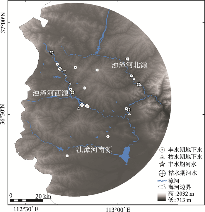
漳河是海河流域南源之一,其上游为浊漳河与清漳河,其中浊漳河源流分为北源、西源、南源(图1),北源发源于山西省榆社柳树沟、西源发源于长治地区沁县的漳源庙、南源发源于山西长子县发鸠山,3条源流与石梁附近汇合后为浊漳河干流,浊漳河与清漳河不同,其流经上党盆地,流域周边为高山,内部多丘陵和平原,地势平缓,黄土覆盖深,植被覆盖较差,水土流失高发,河流泥沙含量较多。浊漳河流域属于温带季风气候,四季分明,夏短冬长,无霜期短,年降水量为560 mm[6]。浊漳河流经地区为山西省长治地区重要的农业耕地主要的分布区,水资源供需矛盾尖锐,地下水超采较重,地表水与地下水转换关系复杂。
图1 海河流域南源漳河上游位置及采样点分布
Fig.1 Location of upstream of the Zhanghe River and the sampling sites in the Haihe River Basin
河水及地下水采集于2016年2月(枯水期)及2016年8月(丰水期),共采集地下水样品30个,地表河水样品16个,降水10个(表1),采样点分布如图1所示。其中氢氧稳定同位素样品采集过程选用20 mL的棕色玻璃瓶封装,样品采集后用封口膜进行密封,置于4℃环境下冷藏。水化学样品采集选用500 mL聚乙烯取样,样品采集前也应进行相应的清洗,采集后封存冷藏。采样现场用手持哈希仪(HQ40d)对水样的pH值、电导等水化学指标进行测试,并记录采样时的温度、湿度信息及地下水埋深情况。
水样的δD和δ18O值在中国科学院荒漠与绿洲生态国家重点实验室进行分析,采用Los Gatos Research Inc.生产的光谱仪(型号 DLT-100)进行测量。δD和δ18O的精度分别达到0.3‰和0.1‰。测定结果用VSMOW进行校正表示。
水化学常规组分在山西师范大学分析测试中心测定。其中K+、Na+、Ca2+、Mg2+由电感耦合等离子体光谱仪(ICP-OES735E)测定,Cl-、SO42+由离子色谱仪(ICS-2100)测定,HCO3-采用甲基橙盐酸滴定测定。
Piper三线图是目前研究和判断水体水化学类型及各离子组分含量的比例关系的重要分析方法[22]。采用Piper三线图法及Gibbs图分析法对研究区2个季节不同水体的水化学特征进行分析。通过Gibbs法对样品的水化学组分研究和分析,判读水体的水化学特征是受控于大气降水控制型、岩石风化控制型和蒸发-结晶控制型[22,23]中的哪一种。运用ArcGIS10.3软件中的克里格插值法对研究区不同季节地表河水及地下水的总固体溶解物(TDS)、pH值以及δD和δ18O做空间插值分析,以分析地表河水及地下水TDS、pH、δD和δ18O的时空分布特征。
借助稳定同位素作为示踪剂,根据质量平衡方程和浓度平衡方程建立二端元混合水源分割模型,定量的分析大气降水、地表河水对于地下水的贡献率。公式如下[10,18]:
式中,Q1、Q2分别为大气降水和地下水补给河水的量;Qn为河水的量;δ1、δ2、δn分别为大气降水、地下水、河水的同位素特征值。经推算,河水与地下水的转化比K1为:
表1 研究区域采样点信息
Table 1 Sampling information of study area
| 河 段 | 类型 | 时间 | 样本 | 埋深 | δD均值 | δ18O均值 | 氘盈余 | pH | TDS | 温度 | 降水量 |
|---|---|---|---|---|---|---|---|---|---|---|---|
| (个) | (m) | (‰) | (‰) | 均值(‰) | (mg/L) | (℃) | (mm) | ||||
| 西源 | 河 水 | 2016.02 | 3 | -40.53 | -4.80 | -2.13 | 8.20 | 647.33 | 2.3 | ||
| 2016.08 | 3 | -62.52 | -8.49 | 5.43 | 7.41 | 922.67 | 21.5 | ||||
| 地下水 | 2016.02 | 9 | 25 | -67.03 | -9.01 | 5.05 | 8.18 | 502.14 | |||
| 2016.08 | 8 | 22 | -62.62 | -8.35 | 4.19 | 7.58 | 558.00 | ||||
| 南源 | 河 水 | 2016.02 | 2 | -28.00 | -2.42 | -8.67 | 7.76 | 116.90 | 3.5 | ||
| 2016.08 | 2 | -64.97 | -8.89 | 6.13 | 7.65 | 455.00 | 22.1 | ||||
| 地下水 | 2016.02 | 3 | 15 | -67.46 | -9.44 | 8.06 | 8.03 | 406.33 | |||
| 2016.08 | 4 | 14 | -59.01 | -8.28 | 7.22 | 7.43 | 536.75 | ||||
| 北源 | 河 水 | 2016.02 | 3 | -54.74 | -6.72 | -0.95 | 8.28 | 629.50 | 2.6 | ||
| 2016.08 | 3 | -57.77 | -7.44 | 1.78 | 7.47 | 815.00 | 20.2 | ||||
| 地下水 | 2016.02 | 3 | 19 | -66.36 | -9.06 | 6.09 | 8.24 | 454.67 | |||
| 2016.08 | 3 | 18 | -64.86 | -8.56 | 3.62 | 7.62 | 521.00 | ||||
| 降水 | 2016.02 | 3 | -74.40 | -10.60 | 59.30 | 11.3 | |||||
| 2016.08 | 7 | -56.12 | -8.11 | 99.20 | 49.6 |
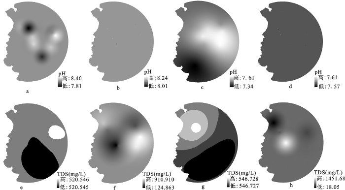
研究区河水各离子以Ca2+、Na+、Cl-、SO42-、HCO3-为主,其中为Ca2+为最主要的阳离子,HCO3-为最主要的阴离子,河水TDS的范围为116.9~1 255.0 mg/L。其中,丰水期河水的TDS(均值为658.7 mg/L)普遍高于枯水期TDS(均值为527.6 mg/L)。河水中主要的离子表现出不一致的季节变化,丰水期较之枯水期河水中Ca2+、HCO3-离子平均含量表现出显著的增加,Na+、Cl-、SO42-呈现出显著的减少,Mg2+、K+无显著的变化(表2)。研究期内河水的pH值介于7.09~8.32之间,呈弱碱性水;其中,丰水期河水的pH值较枯水期河水的pH值略低(表1)。河水的pH值并未表现出显著的空间差异,但河水的TDS在不同季节表现出相异的季节变化,其中枯水期河水的TDS最大值出现在研究区中西部,而丰水期河水TDS出现在研究区的西北部(图2)。
图2 研究区不同时期地下水、河水pH和TDS时空分布 a~d分别为枯水期地下水、河水、丰水期地下水、河水pH;e~h分别为枯水期地下水、河水、丰水期地下水、河水TDS。
Fig.2 Spatio-temproral distribution of groundwater, river water pH and TDS during different period of the study area
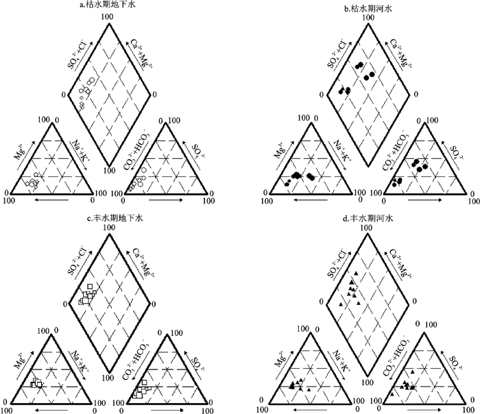
Piper三线图的分析结果显示,枯水期河水的水化学类型以HCO3·SO4-Ca、Cl-Na型为主。而丰水期河流水化学类型较之枯水期发生了一定的变化,水体中Cl–及Na+显著减少,河水的化学类型也转变为HCO3·SO4-Ca、HCO3-Ca型(图3)。
图3 海河源区不同时期地下水、地表河水主要离子Piper三线图
Fig.3 Piper figures of the groundwater, river water of upperstream of the Haihe River during different period
与河水相同,地下水中主离子为Ca2+、Na+、Cl-、SO42-、HCO3-,HCO3-、Ca2+分别为含量最多的阴阳离子。地下水TDS并无显著的季节变化趋势,枯水期地下水的TDS值(514.56 mg/L)略低于丰水期地下水的TDS(525.93 mg/L),水体的主要离子与TDS的变化趋势相同,除K+离子之外,其他的离子都是丰水期地下水略高。地下水的pH值介于7.04~8.31之间,其中枯水期地下水pH值较高呈现弱碱性,地下水pH在丰水期空间差异较显著(图2c)。地下水的TDS呈现出显著的空间差异性,其中丰水期的空间差异更加显著,表明研究区地下水具有明显的补给空间差异。Piper三线图(图3)显示,海河流域源流区地下水水化学类型较为稳定,以HCO3·SO4-Ca、HCO3-Ca型为主,其中丰水期河水与地下水化学类型较为相似,表明这一时期该研究区地下水地表水转化关系密切,而枯水期,地表水、地下水化学存在明显的差异,说明这一时期2种水体之间转化并不明显。
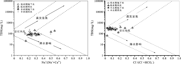
图4中对海河源区两个不同季节的地下水、地表水进行了Gibbs分析,结果显示的水样点分布较为集中,Na+/(Na++Ca2+)和Cl-/(Cl-+HCO3-)变化范围大都集中于0.1~0.4之间,点基本全部落于图的左侧中部,即处于岩石风化控制区。其中丰水期地下水及河水具有一定降水影响特征,但并不是很明显,而枯水期河水的水化学特征主要受控于岩石风化作用。Gibbs的结果进一步证明丰水期地下水和河水受到一定程度降水的影响,地下水与降水间存在相互作用关系,但枯水期的地下水与降水并未表现出显著的相互作用。
图4 海河源区地表水地下水水化学Gibbs图
Fig.4 Hydrochemical Gibbs map of groundwater and river water of upperstream of the Haihe River
表2 研究区域不同水体主要离子含量信息(mg/L)
Table 2 The information of main ions content in different water in the study area (mg/L)
| 时期 | 类型 | 区域 | Na+ | K+ | Mg2+ | Ca2+ | Cl- | HCO3- | SO42- |
|---|---|---|---|---|---|---|---|---|---|
| 枯水期 | 地下水 | 西源 | 23.9 | 0.5 | 16.7 | 62.6 | 11.9 | 283.3 | 23.5 |
| 北源 | 23.5 | 1.7 | 22.9 | 83.5 | 30.4 | 250.0 | 84.3 | ||
| 南源 | 22.6 | 0.7 | 17.8 | 82.3 | 24.0 | 267.8 | 37.7 | ||
| 河水 | 西源 | 29.9 | 3.4 | 14.3 | 53.1 | 31.4 | 219.8 | 62.5 | |
| 北源 | 57.3 | 4.1 | 28.9 | 92.4 | 76.3 | 163.5 | 188.4 | ||
| 南源 | 24.0 | 1.2 | 14.1 | 53.8 | 17.6 | 213.0 | 48.0 | ||
| 丰水期 | 地下水 | 西源 | 23.9 | 2.4 | 21.2 | 65.4 | 21.9 | 267.2 | 58.0 |
| 北源 | 20.9 | 1.5 | 18.7 | 60.8 | 15.9 | 252.3 | 44.1 | ||
| 南源 | 20.6 | 3.3 | 15.8 | 53.9 | 21.8 | 215.1 | 54.7 | ||
| 河水 | 西源 | 25.5 | 2.5 | 19.5 | 66.8 | 27.6 | 228.6 | 92.7 | |
| 北源 | 31.6 | 3.0 | 14.2 | 44.0 | 28.6 | 201.9 | 58.4 | ||
| 南源 | 50.8 | 2.3 | 42.7 | 184.4 | 104.8 | 398.2 | 120.3 |
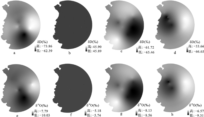
氢氧稳定同位素的分析结果表明,研究区河水δ18O值范围为-9.34‰~-2.42‰,均值为-6.88‰,河水δD值范围为-66.01‰~-27.44‰,均值为-53.65‰,氘盈余(d=δD-8×δ18O)值变动范围为-8.67‰~8.95‰。枯水期河水δD和δ18O的值显著高于丰水期,这与枯水期漳河径流量少,流动缓慢有一定关系。静止或缓慢流动的河水在风的作用下极易发生稳定同位素的蒸发富集,加之研究区冬季较为干燥、降水少(δ18O较贫化),导致枯水期河水的δD和δ18O显著高于丰水期河水。而河水的氘盈余在枯水期大都为负值,进一步表明枯水期河水经历了强烈的蒸发富集作用。地表河水的氢氧稳定同位素在枯水期并未如丰水期河水一样表现出空间差异,河水的分布较为均匀,而丰水期河水在空间上表现为西部较为贫化,东部较为富集的空间分布特征(图5)。
图5 研究区不同时期地下水、河水δD和δ18O时空变化 a~d分别为枯水期地下水、河水、丰水期地下水、河水δD;e~h分别为枯水期地下水、河水、丰水期地下水、河水δ18O。
Fig.5 The spatio-temproral variatin of groundwater, river water δD and δ18O during different period of the study area
研究时期内,地下水δ18O值的变动范围为-10.1‰~-7.51‰,均值为-8.72‰,河水δD值变动范围为-74.41‰~-50.71‰,均值为-64.42‰,地下水的氘盈余值变动范围为-0.57‰~11.69‰,其均值为5.34‰。与地表河水截然不同的是,枯水期地下水的δD和δ18O值低于丰水期地下水,丰水期的较高地下水δD和δ18O值与丰水期地表水的入渗有关[25],地表水下渗进入地下水面前经历了不同程度的蒸发,导致这一时期地下水中重同位素富集。而枯水期地下水的氘盈余与丰水期地下水的氘盈余的差异也进一步说明,枯水期河水的氘盈余较低甚至出现负值,这是水体经受强烈蒸发富集的表现。2个不同时期地下水的氘盈余的差异表明丰水期地下水的水源组成与枯水期有一定差异。
对比研究区2个不同时期的河水氢氧稳定同位素值发现,丰水期地表河水与地下水的δD和δ18O值较为相似,表明这一时期,地表河水与地下水具有较为显著的水力联系;而枯水期地下水δD和δ18O值普遍低于同时期河水的δD和δ18O值,且差异很大,表明这一时期两种水体的水力联系较小。
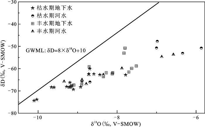
丰水期地下水与地表河水的散点分布较为集中且大都落在全球大气降水线的中部偏下,两者分布位置较为接近(图6),同时这一时期地下水样点也与个别降水样点相近,说明这一时期两种水体间交互作用显著。而枯水期地下水与地表河水的δD和δ18O的散点较为分散,河水样点大都偏离地下水样点,落在全球大气降水线上部的右上方,表明这一时期地表河水δD和δ18O主要受到蒸发富集作用的控制,而地下水的点则集中在中部偏下区域,而与河水、降水间联系较弱。
图6 研究区不同时期地下水、河水δD和δ18O关系
Fig.6 The relationship of δD和δ18O groundwater, river water in different period of the study area
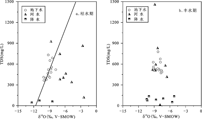
利用研究区内地表水与地下水TDS与δ18O的值进一步分析了降水、河水及地下水在干枯季节的相互关系(图7),结果显示:
图7 研究区不同时期地下水、河水、降水TDS与δ18O关系
Fig.7 The relationship between TDS and δ18O of groundwater, river water and precipitation in different period of the study area
冬季枯水期地下水样点偏离河水及降水,河水TDS虽与地下水TDS较为接近,但两者的δ18O值差异显著。枯水期流动缓慢的地表河水δD和δ18O较富集, 而此时的地下水δD和δ18O较低,说明枯水期河水并未对地下水的有所扰动。丰水期,地下水样点与河水样点分布较为集中,地表水与地下水的水化学及稳定同位素空间差异较小,几个河水的样点与地下水样点高度重合,说明这一时期地下水可能受到地表河水明显的扰动,两者之间存在一定水力联系[25,26]。丰水期大气降水δ18O值与地下水及河水的δ18O值较为接近,但其TDS值低于地下水及河水,结合Gibbs图分析结果(图7),这一时期地下水也受到TDS值较低的降水的扰动。
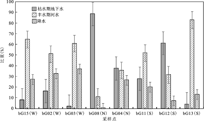
地表水地下水转化关系定量分割结果显示,丰水期,研究区地下水中河水的补给比重在10.95%~82.90%之间,平均为48.72%(图8)。不同的源流段表现出差异明显的地表水地下水转化关系,其中漳河西源地表河水对地下水影响最显著,平均补给比重为58.86%,北源地表河水对地下水影响相对最小,补给比重约为23.37%。
图8 海河源区丰水期典型采样点地表水与地下水补给比例
Fig.8 The relationship between groundwater and surface water in some typical sampling sites during wet season of the Haihe River
研究区地下水、地表水的水化学类型存在着季节差异,枯水期河水的水化学类型以HCO3·SO4-Ca、Cl-Na型为主,地下水水化学类型为HCO3·SO4-Ca、HCO3-Ca型。岩石风化是研究区水体的水化学性质的主要控制因素,降水对丰水期水化学特征有一定影响。地下水的TDS空间差异显著,其中丰水期地下水的TDS空间差异更加显著。河水的δD和δ18O值在枯水期高于丰水期,枯水期地下水的δD和δ18O值低于丰水期地下水,不同水体氘盈余并无显著差异。丰水期河水及大气降水对丰水期的地下水具有显著的补给作用,枯水期水体间水力联系较弱。丰水期地下水中河水的补给比重在10.95%~82.90%之间,平均补给比重为48.72%。其中以浊漳河西源的地表河水对地下水影响最显著。
The authors have declared that no competing interests exist.
| [1] |
海河流域地表水与地下水耦合模拟 [J].https://doi.org/10.11820/dlkxjz.2011.11.003 Magsci [本文引用: 3] 摘要
近10 年来海河流域地下水超采严重,急需加强流域地表水与地下水统一管理。地表水与地下水的耦合模拟研究是实现流域地表与地下水资源综合管理的重要支撑。本文探讨了当前3 种不同的地表水与地下水耦合方式,基于现有数据条件和应用管理的需求,提出了将成熟的流域地表水SWAT与地下水MODFLOW模型进行松散耦合的技术框架,并构建了海河流域地表水与地下水耦合模型。在流域地表空间上,根据流域特性和管理需求,划分了283 个子流域和2100 个水文响应单元(HRU);在平原区地下空间上,基于15 个大的岩性分区剖分出若干个4 km × 4 km网格。通过GIS平台,建立流域地表水与地下水计算单元的转换关系。并利用1995-2004 年水文气象数据进行验证分析,取得较好模拟精度。该耦合模型不仅能够支撑流域现状管理,而且可用于气候变化与南水北调工程对流域水资源影响评估分析。
A coupled surface-water/groundwater model for Haihe river basin. Progress in https://doi.org/10.11820/dlkxjz.2011.11.003 Magsci [本文引用: 3] 摘要
近10 年来海河流域地下水超采严重,急需加强流域地表水与地下水统一管理。地表水与地下水的耦合模拟研究是实现流域地表与地下水资源综合管理的重要支撑。本文探讨了当前3 种不同的地表水与地下水耦合方式,基于现有数据条件和应用管理的需求,提出了将成熟的流域地表水SWAT与地下水MODFLOW模型进行松散耦合的技术框架,并构建了海河流域地表水与地下水耦合模型。在流域地表空间上,根据流域特性和管理需求,划分了283 个子流域和2100 个水文响应单元(HRU);在平原区地下空间上,基于15 个大的岩性分区剖分出若干个4 km × 4 km网格。通过GIS平台,建立流域地表水与地下水计算单元的转换关系。并利用1995-2004 年水文气象数据进行验证分析,取得较好模拟精度。该耦合模型不仅能够支撑流域现状管理,而且可用于气候变化与南水北调工程对流域水资源影响评估分析。
|
| [2] |
Recent advances in understanding the interaction of groundwater and surface water [J].https://doi.org/10.1029/95RG00115 URL [本文引用: 1] 摘要
Not Available
|
| [3] |
Stream-groundwater exchange and hydrologic turnover at the network scale [J].https://doi.org/10.1029/2011WR010942 URL [本文引用: 1] 摘要
The exchange of water between streams and groundwater can influence stream water quality, hydrologic mass balances, and attenuate solute export from watersheds. We used conservative tracer injections (chloride, Cl) across 10 stream reaches to investigate stream water gains and losses from and to groundwater at larger spatial and temporal scales than typically associated with hyporheic exchanges. We found strong relationships between reach discharge, median tracer velocity, and gross hydrologic loss across a range of stream morphologies and sizes in the 11.4 kmBull Trout Watershed of central ID. We implemented these empirical relationships in a numerical network model and simulated stream water gains and losses and subsequent fractional hydrologic turnover across the stream network. We found that stream gains and losses from and to groundwater can influence source water contributions and stream water compositions across stream networks. Quantifying proportional influences of source water contributions from runoff generation locations across the network on stream water composition can provide insight into the internal mechanisms that partially control the hydrologic and biogeochemical signatures observed along networks and at watershed outlets.
|
| [4] |
Quantifying water and energy budgets and the impacts of climatic and human factors in the Haihe river basin, China: 1. Model and validation [J].https://doi.org/10.1016/j.jhydrol.2015.04.071 URL [本文引用: 2] 摘要
In this paper, spatial and temporal changes in water and energy fluxes were investigated over the past 28years along with relevant factors in the Haihe River Basin in North China, which is currently facing an increasingly severe water shortage. Water and energy fluxes in different topographical regions have been affected by both climate change and human activities. In the plain regions, actual evapotranspiration (ETa) has generally decreased during the study period, which can be attributed to decreased net radiation, precipitation and rapid urbanization. The water deficit has continued in the plains regions due to extensive pumping for irrigation to meet the deficit of crop water. However, irrigation has led to significant groundwater depletion, which poses a significant challenge to the sustainability of water resources. In the mountain regions, decreases in sensible heat flux and increases in ETa have caused a decrease in the Bowen ratio. These changes in water and energy fluxes have brought a positive ecological effect, but the increase in ETa in the mountain regions has resulted in a substantial reduction of water yield and consequently a negative effect on water resources in this basin. These changes in water and energy fluxes across the Haihe River Basin have made the water issue more complex and require integrated river basin management.
|
| [5] |
Quantifying water and energy budgets and the impacts of climatic and human factors in the Haihe river basin, China: 2. Trends and implications to water resources [J].https://doi.org/10.1016/j.jhydrol.2015.04.071 URL [本文引用: 2] 摘要
In this paper, spatial and temporal changes in water and energy fluxes were investigated over the past 28years along with relevant factors in the Haihe River Basin in North China, which is currently facing an increasingly severe water shortage. Water and energy fluxes in different topographical regions have been affected by both climate change and human activities. In the plain regions, actual evapotranspiration (ETa) has generally decreased during the study period, which can be attributed to decreased net radiation, precipitation and rapid urbanization. The water deficit has continued in the plains regions due to extensive pumping for irrigation to meet the deficit of crop water. However, irrigation has led to significant groundwater depletion, which poses a significant challenge to the sustainability of water resources. In the mountain regions, decreases in sensible heat flux and increases in ETa have caused a decrease in the Bowen ratio. These changes in water and energy fluxes have brought a positive ecological effect, but the increase in ETa in the mountain regions has resulted in a substantial reduction of water yield and consequently a negative effect on water resources in this basin. These changes in water and energy fluxes across the Haihe River Basin have made the water issue more complex and require integrated river basin management.
|
| [6] |
漳河上游地表水与地下水相互作用规律研究[D] .The study of the interaction rule between surfacewater and groundwater in the upstream of Zhanghe River . |
| [7] |
海河流域水资源安全评价 [J].https://doi.org/10.3969/j.issn.1007-6301.2003.04.006 URL Magsci [本文引用: 1] 摘要
利用已建立的评价指标体系,对海河流域水资源安全现状进行评价。在海河流域的当地水资源量按372×108m3计算、引黄水量为60×108m3的条件下,海河流域的水资源保障是不安全的。但这种不安全属于气候干旱周期的不安全,如果气候转为类似1950~1970时期的湿润期,海河流域从水量来说就是安全的。海河流域的水资源不安全更突出的是水质不安全,所以加强水污染防治工作是提高海河流域水资源安全程度的首要选择。
Water resources security appraisement of Haihe Basin .https://doi.org/10.3969/j.issn.1007-6301.2003.04.006 URL Magsci [本文引用: 1] 摘要
利用已建立的评价指标体系,对海河流域水资源安全现状进行评价。在海河流域的当地水资源量按372×108m3计算、引黄水量为60×108m3的条件下,海河流域的水资源保障是不安全的。但这种不安全属于气候干旱周期的不安全,如果气候转为类似1950~1970时期的湿润期,海河流域从水量来说就是安全的。海河流域的水资源不安全更突出的是水质不安全,所以加强水污染防治工作是提高海河流域水资源安全程度的首要选择。
|
| [8] |
近50年海河流域径流的变化趋势研究 [J].https://doi.org/10.3969/j.issn.1001-7313.2004.04.001 URL [本文引用: 1] 摘要
该文用Mann-Kendall 方法对近50年海河流域山区20个子流域的径流及降水的变化趋势进行了显著性检验,结合降水,径流及气温的年代距平值的同步分析以及径流对气候变化的敏感性研究结果,对近50年海河流域径流的变化趋势,提出了一个半定量分析的研究思路和方法。提出影响径流变化的三种类型:以气候暖干化为主,人类活动为辅的径流显著衰减型;以人类活动为主,气候暖干化为辅的径流显著衰减型;人类活动与气候变异都不明显,径流无显著变化的类型。分析结果展示了气候、人类活动与水之间的相互作用。这种相互作用,给径流的变化趋势分析和成因分析带来了复杂性与困难,也给气候变化对水资源的影响研究提出了挑战。
Study of trends in runoff for the Haihe river basin in recent 50 years .https://doi.org/10.3969/j.issn.1001-7313.2004.04.001 URL [本文引用: 1] 摘要
该文用Mann-Kendall 方法对近50年海河流域山区20个子流域的径流及降水的变化趋势进行了显著性检验,结合降水,径流及气温的年代距平值的同步分析以及径流对气候变化的敏感性研究结果,对近50年海河流域径流的变化趋势,提出了一个半定量分析的研究思路和方法。提出影响径流变化的三种类型:以气候暖干化为主,人类活动为辅的径流显著衰减型;以人类活动为主,气候暖干化为辅的径流显著衰减型;人类活动与气候变异都不明显,径流无显著变化的类型。分析结果展示了气候、人类活动与水之间的相互作用。这种相互作用,给径流的变化趋势分析和成因分析带来了复杂性与困难,也给气候变化对水资源的影响研究提出了挑战。
|
| [9] |
海河流域二元水循环模式及其演化规律 [J].https://doi.org/10.1360/csb2010-55-6-512 URL Magsci [本文引用: 1] 摘要
海河流域是我国乃至世界上受人类活动干扰最强烈的区域,其水循环的二元演化特征十分明显,水资源的利用和循环转化关系极为复杂.社会(侧支)水循环通量的膨胀几乎吸干了所有的天然径流,工业、农业及生活排污致使水质严重恶化,流域呈现出有河皆干、有水皆污的局面.传统的以天然水循环为主的“实测-还原”研究模式已不能适应现代水资源研究的需要.以海河流域为原型对象,通过科学抽象和理性思考,勾勒出了二元水循环模式的系统图景,分析了二元水循环的关键要素、平衡方程以及演变历程.应用建立的二元水循环模式理论,通过收集最新的数据资料,研究了海河流域二元水循环十项关键要素的演化规律,并在此基础上提出了海河流域的健康水循环模式及其调控方向.
Dualistic water cycle pattern and its evolution in Haihe river basin .https://doi.org/10.1360/csb2010-55-6-512 URL Magsci [本文引用: 1] 摘要
海河流域是我国乃至世界上受人类活动干扰最强烈的区域,其水循环的二元演化特征十分明显,水资源的利用和循环转化关系极为复杂.社会(侧支)水循环通量的膨胀几乎吸干了所有的天然径流,工业、农业及生活排污致使水质严重恶化,流域呈现出有河皆干、有水皆污的局面.传统的以天然水循环为主的“实测-还原”研究模式已不能适应现代水资源研究的需要.以海河流域为原型对象,通过科学抽象和理性思考,勾勒出了二元水循环模式的系统图景,分析了二元水循环的关键要素、平衡方程以及演变历程.应用建立的二元水循环模式理论,通过收集最新的数据资料,研究了海河流域二元水循环十项关键要素的演化规律,并在此基础上提出了海河流域的健康水循环模式及其调控方向.
|
| [10] |
白洋淀渗漏对周边地下水的影响 [J].https://doi.org/CNKI: 32.1309.P.20121101.1801.020 Magsci [本文引用: 3] 摘要
为查明受污染的白洋淀地表水渗漏范围,对周边地下水主要离子水化学的影响,并评价地下水是否适用于灌溉,在该区域现场测定了地表水及地下水pH、EC(Electric Conductivity)和ORP(Oxidation-Reduction Potential)等参数,采样分析各水体D、<sup>18</sup>O和主要离子组成,结合判别分析和钠吸附比<em>R</em><sub>SA</sub>(Sodium Adsorption Ratio)讨论。结果表明,淀水渗漏使浅层地下水电导率升高,氧化还原电位值降低,且更加富集重同位素;唐河污水库周边浅层地下水SO<sub>4</sub><sup>2-</sup>和Na<sup>+</sup>含量明显增大。浅层地下水的δ<sup>18</sup>O值结合水位埋深有效地标记了淀水渗漏影响地下水的范围。浅层地下水主要受到白洋淀渗漏的影响,唐河污水库附近的浅层地下水受污水库渗漏影响。污染地表水渗漏使得浅层地下水水质普遍下降,白洋淀西部和唐河污水库周边浅层地下水不适宜用于灌溉。
Impacts of percolation in Baiyangdian Lake on groundwater. Advances in Water Science Wang Peng Impacts of percolation in Baiyangdian Lake on groundwater .https://doi.org/CNKI: 32.1309.P.20121101.1801.020 Magsci [本文引用: 3] 摘要
为查明受污染的白洋淀地表水渗漏范围,对周边地下水主要离子水化学的影响,并评价地下水是否适用于灌溉,在该区域现场测定了地表水及地下水pH、EC(Electric Conductivity)和ORP(Oxidation-Reduction Potential)等参数,采样分析各水体D、<sup>18</sup>O和主要离子组成,结合判别分析和钠吸附比<em>R</em><sub>SA</sub>(Sodium Adsorption Ratio)讨论。结果表明,淀水渗漏使浅层地下水电导率升高,氧化还原电位值降低,且更加富集重同位素;唐河污水库周边浅层地下水SO<sub>4</sub><sup>2-</sup>和Na<sup>+</sup>含量明显增大。浅层地下水的δ<sup>18</sup>O值结合水位埋深有效地标记了淀水渗漏影响地下水的范围。浅层地下水主要受到白洋淀渗漏的影响,唐河污水库附近的浅层地下水受污水库渗漏影响。污染地表水渗漏使得浅层地下水水质普遍下降,白洋淀西部和唐河污水库周边浅层地下水不适宜用于灌溉。
|
| [11] |
地表水渗漏对娘子关岩溶泉泉水水质的影响 [J].Influence of surface water seepage on water quality in Niangziguan Spring Area . |
| [12] |
河西内陆河地表水与地下水转化及水资源利用率研究 [J].https://doi.org/10.3969/j.issn.1000-0240.2001.04.007 URL Magsci [本文引用: 1] 摘要
Desert and arid areas in Northwest accounts for 34.6% of the total territory of China. Precipitation in these areas is rare, resulting in dry climate and short water resources. Therefore land resources are unbalanced with water resources in these areas. Owing to very strong evaporation and transpiration in desert, the surface water decreases with flow distance and finally flows into some inland lakes. The average annual precipitation is only 153.9 mm, whereas the evaporation is very high, from 1 200 mm to 2 692 mm. The water from high mountainous is consumed by evaporation and infiltration. In irrigation districts water can be obtained by capturing nature wastage in desert oasis. Most of water from mountain areas infiltrates in the upper pluvial fan and then transforms into groundwater. This transformation decreases the futile water, that is, decreuses the lost through evaporation and transpiration. The special topography features make the runoff and groundwater change repeatedly. All above made it possible that the water has relative high utilization efficiency in certain extent. So to understand and grasp the mechanism of water cycle and transformation in Northwest China is very important to sustainable development of society economy system. Hexi Region is a typical arid area. The water of Hexi Region derived from the Qilian Mountains flows into desert plain regions and gradually dwindles and finally disappears. Surface water and groundwater transfer each other frequently. In the region the agriculture depends on irrigation. The study of water resources in Hexi Region has a large progress. Repeatedly transform between surface water and groundwater is found, which has a significance for water resources utilization. Because the water utilization efficiency is very high in Hexi Region, 133% on average in 1999. The utilization efficiency in the Shiyang River Basin is 211%, in the Heihe River Basin is 128%, but in the Shule River Basin is 61.4%, depending on geologic structure and water transformation process. Contrary by the high water utilization ratio and irrational utilization, these cause many environment problem that derived from ignorance to hydrological cycle process and mechanism. Illimitably reclaiming and irrational using water resources acutely decreases the downstream runoff, and descendes the groundwater level. The level has descended 3~5 m on average since 1950’s. Especially, in the plains before mountains the descending trend of groundwater level is markedly. Thus less groundwater replenishes surface water. The water flowing into Minqin Basin has decreased from 5.7×10m·ato 1.5×10m·a since the 1950’s, the groundwater level has descended to 15 m from 3m in the 1950’s, and the exploitable groundwater has decreased to 5.5×10~6.0×10m·a, resulting in many wellsprings disappearing and 0.644×10hm oleaster shelter belt vanishing. Moreover, 0.25×10hm of farmland is abandoned owing to desertification.
Studies of the transformation between surface water and groundwater and the utilization ratio of water resources in Hexi region .https://doi.org/10.3969/j.issn.1000-0240.2001.04.007 URL Magsci [本文引用: 1] 摘要
Desert and arid areas in Northwest accounts for 34.6% of the total territory of China. Precipitation in these areas is rare, resulting in dry climate and short water resources. Therefore land resources are unbalanced with water resources in these areas. Owing to very strong evaporation and transpiration in desert, the surface water decreases with flow distance and finally flows into some inland lakes. The average annual precipitation is only 153.9 mm, whereas the evaporation is very high, from 1 200 mm to 2 692 mm. The water from high mountainous is consumed by evaporation and infiltration. In irrigation districts water can be obtained by capturing nature wastage in desert oasis. Most of water from mountain areas infiltrates in the upper pluvial fan and then transforms into groundwater. This transformation decreases the futile water, that is, decreuses the lost through evaporation and transpiration. The special topography features make the runoff and groundwater change repeatedly. All above made it possible that the water has relative high utilization efficiency in certain extent. So to understand and grasp the mechanism of water cycle and transformation in Northwest China is very important to sustainable development of society economy system. Hexi Region is a typical arid area. The water of Hexi Region derived from the Qilian Mountains flows into desert plain regions and gradually dwindles and finally disappears. Surface water and groundwater transfer each other frequently. In the region the agriculture depends on irrigation. The study of water resources in Hexi Region has a large progress. Repeatedly transform between surface water and groundwater is found, which has a significance for water resources utilization. Because the water utilization efficiency is very high in Hexi Region, 133% on average in 1999. The utilization efficiency in the Shiyang River Basin is 211%, in the Heihe River Basin is 128%, but in the Shule River Basin is 61.4%, depending on geologic structure and water transformation process. Contrary by the high water utilization ratio and irrational utilization, these cause many environment problem that derived from ignorance to hydrological cycle process and mechanism. Illimitably reclaiming and irrational using water resources acutely decreases the downstream runoff, and descendes the groundwater level. The level has descended 3~5 m on average since 1950’s. Especially, in the plains before mountains the descending trend of groundwater level is markedly. Thus less groundwater replenishes surface water. The water flowing into Minqin Basin has decreased from 5.7×10m·ato 1.5×10m·a since the 1950’s, the groundwater level has descended to 15 m from 3m in the 1950’s, and the exploitable groundwater has decreased to 5.5×10~6.0×10m·a, resulting in many wellsprings disappearing and 0.644×10hm oleaster shelter belt vanishing. Moreover, 0.25×10hm of farmland is abandoned owing to desertification.
|
| [13] |
基于氢氧同位素的岔巴沟流域地表水—地下水转化关系研究 [J].https://doi.org/10.3969/j.issn.1005-0930.2009.01.002 URL [本文引用: 1] 摘要
以黄土高原丘陵沟壑区岔巴沟流域为研究对象,通过2005年6 月、8月两次对地表水、地下水采样,分析8D、818O、电导率(EC)和pH的变化,研究了岔巴沟流域的地表水一地下水转化关系.河水的氢氧同位素和 EC沿河道变化大;主河道河水的δ值沿程富集,而EC在6月份时逐渐增加而8月份则先减小后增大;地下水δ值变幅较小而EC变化大.结果表明,旱季,河水 接受以泉水为主要排泄形式的地下水补给,流量很小,在部分河段甚至干涸,仅在中游部分河段,由于河道两侧地下水位下降,基流或降雨径流对地下水形成一定的 补给,但在其它河段没有明显的补给;雨季,降雨径流的退水过程快,洪水补给地下水的时间短且局限在河道两侧,洪峰过后,地表径流源于基岩裂隙泉以及各支沟 淤地坝拦蓄的降雨径流,中游河水接受基岩裂隙泉水及各支流的补给量增加,而下游支流及泉水流量小,对地表径流量的贡献小,地表水沿程经历强烈蒸发,仅河道 附近的地下水接受河水补给.淤地坝减少地下水排泄,增加地下水的转化量以及淤积层、地表径流的矿化度,但尚未明显影响地下水水质.
Interactions between surface water and groundwater in Chabagou Catchment using hydrogen and oxygen isotopes .https://doi.org/10.3969/j.issn.1005-0930.2009.01.002 URL [本文引用: 1] 摘要
以黄土高原丘陵沟壑区岔巴沟流域为研究对象,通过2005年6 月、8月两次对地表水、地下水采样,分析8D、818O、电导率(EC)和pH的变化,研究了岔巴沟流域的地表水一地下水转化关系.河水的氢氧同位素和 EC沿河道变化大;主河道河水的δ值沿程富集,而EC在6月份时逐渐增加而8月份则先减小后增大;地下水δ值变幅较小而EC变化大.结果表明,旱季,河水 接受以泉水为主要排泄形式的地下水补给,流量很小,在部分河段甚至干涸,仅在中游部分河段,由于河道两侧地下水位下降,基流或降雨径流对地下水形成一定的 补给,但在其它河段没有明显的补给;雨季,降雨径流的退水过程快,洪水补给地下水的时间短且局限在河道两侧,洪峰过后,地表径流源于基岩裂隙泉以及各支沟 淤地坝拦蓄的降雨径流,中游河水接受基岩裂隙泉水及各支流的补给量增加,而下游支流及泉水流量小,对地表径流量的贡献小,地表水沿程经历强烈蒸发,仅河道 附近的地下水接受河水补给.淤地坝减少地下水排泄,增加地下水的转化量以及淤积层、地表径流的矿化度,但尚未明显影响地下水水质.
|
| [14] |
北京东南郊再生水灌区不同水体氢氧同位素特征及成因 [J].Characterizing the hydrogen and oxygen isotopic compositions of different waters at reclaimed water irrigated district in southeast suburb of Beijing . |
| [15] |
基于δD和δ18O及水化学的永定河流域地下水循环特征解析 [J].https://doi.org/10.3321/j.issn:1000-3037.2007.03.011 URL Magsci [本文引用: 2] 摘要
运用环境同位素和水化学成分作为水循环研究的示踪剂, 揭示了永定河流域中下游地下水循环特征。通过现场调查并对浅层和深层地下水采样, 进行室内水化学和氢氧同位素组成测定, 分析了流域内深层和浅层地下水的氢氧同位素和水化学组成的空间分布规律和演化趋势, 揭示了流域地下水循环特征。结果表明, 降水是山前地下水的主要补给源, 地下水在接受降水的补给后经过了不同程度的蒸发作用, 山区受蒸发影响较小, 平原区较大, 尤其是平原区浅层地下水呈现出强烈的蒸发浓缩作用; 水化学特征表现为自西部山区到山前平原至滨海平原, 自浅层到深层, 地下水的矿化度逐渐升高; 平原区浅层和深层地下水含水层之间存在明显的越流补给现象; 沿海地区未发现海水入侵现象。
A study of groundwater cycle in Yongding river basin by using δD, δ18O and hydrochemical data .https://doi.org/10.3321/j.issn:1000-3037.2007.03.011 URL Magsci [本文引用: 2] 摘要
运用环境同位素和水化学成分作为水循环研究的示踪剂, 揭示了永定河流域中下游地下水循环特征。通过现场调查并对浅层和深层地下水采样, 进行室内水化学和氢氧同位素组成测定, 分析了流域内深层和浅层地下水的氢氧同位素和水化学组成的空间分布规律和演化趋势, 揭示了流域地下水循环特征。结果表明, 降水是山前地下水的主要补给源, 地下水在接受降水的补给后经过了不同程度的蒸发作用, 山区受蒸发影响较小, 平原区较大, 尤其是平原区浅层地下水呈现出强烈的蒸发浓缩作用; 水化学特征表现为自西部山区到山前平原至滨海平原, 自浅层到深层, 地下水的矿化度逐渐升高; 平原区浅层和深层地下水含水层之间存在明显的越流补给现象; 沿海地区未发现海水入侵现象。
|
| [16] |
湘江流域岳麓山周边地区不同水体中氢氧稳定同位素特征及相互关系 [J].Characteristics of the stable isotopes in different water bodies and their relationships in surrounding areas of Yuelu mountain in the Xiangjiang river basin . |
| [17] |
北京西山鹫峰地区氢氧稳定同位素特征分析 [J].
The rocky mountain areas in Northern China are confronted with water resources scarceness due to the sustainable development and utilization of the precious resources. To effectively utilize limited water resources, the isotope techniques are widely used to study the movement of water in hydrological cycle. The study was conducted at the Jiufeng low mountain region of West Beijing. We identify the transforming relationships among those water sources in Jiufeng through analyzing the isotopic variations of precipitation, soil water and spring water. Results show that the water line in rainy season in Jiufeng is significantly different from the local meteoric water line in Beijing, both slope and intercept of the water line in rainy season are smaller than that of the local meteoric water line, along with the rain, the characteristics of D and O have scheduled changes and rainfall effect, and the scheduled changes in precipitation also affect the soil water isotopic characteristics. The isotopic compositions of soil water are relatively concentrated in the study region. Both slope and intercept of evaporation line equation are smaller than that of the local meteoric water line and the rainy seasonal water line. The soil in Quercus Variabilis Mixed Forest is not sensitive to small precipitation events. The soil water movement in Platycladus Oriatalis plots is faster than that in Quercus Variabilis Mixed Forest, which can account for the affection of forest types and soil characteristics to the conversion between different water sources. The isotopic composition of spring water is relatively stable, and they mainly distribute on the bottom right of the local meteoric water line, near the intersection point with the rainy seasonal water line. There have different isotope variations among different water sources. The largest variation is in rain water and the least is in spring water. The values of hydrogen and oxygen isotopes in different water sources decrease with the water cycle path from precipitation to soil water, and then to ground water.
An analysis of characteristics of hydrogen Jia Guodong An analysis of characteristics of hydrogen and oxygen stable isotopes in Jiufeng mountain areas of Beijing .
The rocky mountain areas in Northern China are confronted with water resources scarceness due to the sustainable development and utilization of the precious resources. To effectively utilize limited water resources, the isotope techniques are widely used to study the movement of water in hydrological cycle. The study was conducted at the Jiufeng low mountain region of West Beijing. We identify the transforming relationships among those water sources in Jiufeng through analyzing the isotopic variations of precipitation, soil water and spring water. Results show that the water line in rainy season in Jiufeng is significantly different from the local meteoric water line in Beijing, both slope and intercept of the water line in rainy season are smaller than that of the local meteoric water line, along with the rain, the characteristics of D and O have scheduled changes and rainfall effect, and the scheduled changes in precipitation also affect the soil water isotopic characteristics. The isotopic compositions of soil water are relatively concentrated in the study region. Both slope and intercept of evaporation line equation are smaller than that of the local meteoric water line and the rainy seasonal water line. The soil in Quercus Variabilis Mixed Forest is not sensitive to small precipitation events. The soil water movement in Platycladus Oriatalis plots is faster than that in Quercus Variabilis Mixed Forest, which can account for the affection of forest types and soil characteristics to the conversion between different water sources. The isotopic composition of spring water is relatively stable, and they mainly distribute on the bottom right of the local meteoric water line, near the intersection point with the rainy seasonal water line. There have different isotope variations among different water sources. The largest variation is in rain water and the least is in spring water. The values of hydrogen and oxygen isotopes in different water sources decrease with the water cycle path from precipitation to soil water, and then to ground water.
|
| [18] |
基于氢氧同位素与水化学的潮白河流域地下水水循环特征 [J].https://doi.org/10.3321/j.issn:1000-0585.2007.01.002 URL [本文引用: 2] 摘要
为了研究变化环境下潮白河流域地下水水循环规律,通过现场调查,结合环境同位素及水化学应用,对潮白河流域浅层和深层地下水采样,测定其氢、氧环境同位素及水化学成分,通过分析其变化特征判明地下水的补给来源以及各含水层的相互联系。降水和地下水中的环境同位素δD和1δ8O组成分析表明,降水是山前地下水的主要补给源,山区浅层地下水受蒸发影响非常强烈。水化学研究结果表明,山区地下水水质以Ca2+和HCO3为主,属Ca2+-Mg2+-HCO3型地下水。山前地下水类型为Ca2+-Mg2+-HCO3、Na+-K+-HCO3、Mg2+-Ca2+-HCO3和Ca2+-Mg2+-Cl-SO24。平原区地下水为Mg2+,N
Characteristics of groundwater cycle using deuterium, oxygen 18 and hydrochemistry in Chaobai River Basin .https://doi.org/10.3321/j.issn:1000-0585.2007.01.002 URL [本文引用: 2] 摘要
为了研究变化环境下潮白河流域地下水水循环规律,通过现场调查,结合环境同位素及水化学应用,对潮白河流域浅层和深层地下水采样,测定其氢、氧环境同位素及水化学成分,通过分析其变化特征判明地下水的补给来源以及各含水层的相互联系。降水和地下水中的环境同位素δD和1δ8O组成分析表明,降水是山前地下水的主要补给源,山区浅层地下水受蒸发影响非常强烈。水化学研究结果表明,山区地下水水质以Ca2+和HCO3为主,属Ca2+-Mg2+-HCO3型地下水。山前地下水类型为Ca2+-Mg2+-HCO3、Na+-K+-HCO3、Mg2+-Ca2+-HCO3和Ca2+-Mg2+-Cl-SO24。平原区地下水为Mg2+,N
|
| [1] |
Hydrochemical and isotopic characteristics of groundwater in the Yanqi basin of Xinjiang province, Northwest China [J].https://doi.org/10.1007/s12665-013-2450-8 URL Magsci [本文引用: 1] 摘要
In this study, hydrochemical and isotope investigations were conducted in the Yanqi Basin to determine the chemical composition, and to gain insight into the groundwater recharge process in the Yanqi Basin. It mainly used hydrochemistry, environmental isotopes, and a series of comprehensive data interpretation, e.g., statistics, ionic ratios, and Piper diagram to obtain a better understanding of the functioning of the system. The following hydrochemical processes were identified as the main factors controlling the water quality of the groundwater system: weathering of silicate minerals, dissolution, ion exchange, and to a lesser extent, evaporation, which seemed to be more pronounced down gradient of the flow system. As groundwater flows from the recharge to discharge areas, chemical patterns evolve in the order of Ca 2+ –HCO 3 61 , Ca 2+ /Mg 2+ –HCO 3 61 to Ca 2+ –Mg 2+ –Cl 61 –SO 4 261 , Na + –K + –Cl 61 –SO 4 261 and Na + –Cl 61 according to lithology. The environmental isotope ( δ 18 O, δ 2 H, 3 H) measurements further revealed that precipitation was the main recharge source for the groundwater system; some local values indicated high levels of evaporation. Tritium and CFC analysis were used to estimate the ages of the different groundwater; the tritium values of the groundwater samples varied from 2.82 to 29.702TU. The age of the groundwater at depths of <12002m is about 30–5002years. CFC values obtained for six samples to determine groundwater age; the age of the groundwater is about 20–5002years.
|
| [20] |
Changes in groundwater induced by water diversion in the lower Tarim river, Xinjiang Uygur, NW China: Evidence from Environmental Isotopes and Water Chemistry [J].https://doi.org/10.1016/j.jhydrol.2010.04.007 URL [本文引用: 1] 摘要
The Lower Tarim River in NW China is under severe ecosystem degradation due to stopped stream flow and diminished groundwater recharge. Since year 2000, eight water diversions from the upper stream and from the neighboring Kaidu–Kongque River have been implemented to alleviate the ecosystem disaster. In order to assess the effectiveness of the water diversion project and to identify proper tracers of groundwater dynamics, we sampled the riparian groundwater system in 2007 and 2008 along the 350 km-long river channel through the 40 monitoring wells situated along nine transects perpendicular to the river and three soil profiles. Measurements on the samples have included environmental isotopes ( 18O, 2H, 3H) and water chemistry. The results show that remarkable changes have been induced by the water diversions. The observed response of riparian groundwater system includes general decrease in total dissolved solid (TDS) and rise of water table. Scope with greater than 1 m rise in water table is within 65700 m from the riverbank in the upper segments and 65300 m in the lower ones. Greater rise of water table occurs near the river bank. Tritium data show that the extent of modern recharge (since 1960s), including that from the diverted water, is limited to 600 m from the riverbank at the upper segments and 200 m at the lower ones. Stable isotopes show that groundwaters, regardless of modern or pre-modern, are enriched in heavy isotopes and are plotted in parallel to the meteoric water line in the δ–δ plot, attributed to evaporation during recharge. Groundwater is generally of Na–Mg–Cl–SO 4 type and is formed by dissolution of minerals, such as halite, sulfate, and carbonates, based on component correlation matrices analysis. The salinity of groundwater is mainly affected by that of the diverted water and of the local antecedent groundwater, salts in the unsaturated zone, evapotranspiration during recharge. As the zone of smaller groundwater depth (less than 5 m) suitable for the most existing Populus euphratica and Tamarix ramosissima, the main species targeted by the rescue effort, restricts to 200 m from the riverbank, and narrows down towards downstream, long-term stability of the ecosystem cannot be achieved by the current water diversion scheme and regulating/saving water in source-streams and the Upper/Middle Tarim River is crucial for continuing water diversion.
|
| [21] |
Photocatalytic transformation of acesulfame: transformation products identification and embryotoxicity study [J].https://doi.org/10.1016/j.watres.2015.11.035 URL PMID: 26630044 [本文引用: 2] 摘要
61Acesulfame undergoes photocatalytic transformation upon UV-C irradiation.61Six additional transformation products of acesulfame are identified.61Hydrolysis and oxidation are proposed to be the two main degradation mechanisms.61Transformation products in mixture produce adverse effects in fish embryo development.
|
| [22] |
|
| [23] |
Isotopic time-series partitioning of stream flow components under regional climate change in the Urumqi river, northwest China [J].https://doi.org/10.1080/02626667.2015.1031757 URL [本文引用: 3] 摘要
We investigated the isotopic composition of the Urumqi River and documented seasonal variability attributable to the mixing of various flow sources. Next, we applied these isotopic signals to partition the sources and studied their temporal variability in summer. The isotope hydrology separation results indicated that groundwater is the dominant streamflow source (approximately 62.7%) in the Urumqi River. Precipitation is an important source for the Urumqi River; approximately 19.1 20.7% of the runoff came from precipitation during summer and early autumn. In summer, approximately 21.1% of the runoff is derived from glacial meltwater. In summer, with the increasing distance to the glacier front, groundwater accounts for a larger and larger percentage of the river water, and the contributions of precipitation and glacial meltwater gradually diminish. Throughout 2012, the proportions of precipitation and glacial meltwater in the streamflow were 17.6% and 14.7%, respectively, and only 5% of the streamflow was derived from snowmelt.Editor Z. W. Kundzewicz; Associate editor not assigned
|
| [24] |
华北平原地下水与地表水的水文地球化学及氢氧同位素特征分析[D] .Analysis of hydrogeochemical and stabe isotopes of surface water and groundwater in North China Plain . |
| [25] |
外来调水对华北低平原区地表水和地下水水化学特征的影响——以河北省南皮县为例 [J].
华北低平原区有着巨大的粮食增产潜力, 同时也是粮食生产和农业水资源矛盾突出的地区。外来调水与浅层微咸水的联合利用是解决区域水资源问题的有效途径之一, 同时也将引起区域水循环和水环境的改变。为明确外来调水对华北低平原区地表水和地下水水化学特征的影响, 本研究在华北低平原区河北省南皮县域内对调水后不同季节地表水和地下水进行调查和采样, 利用水文地球化学和氢氧(<sup>2</sup>H、<sup>18</sup>O)稳定同位素相结合的方法, 研究外来调水对地表水和地下水转化及其水化学特征的影响。研究结果表明, 11月至翌年7月, 受蒸发作用的影响, 地表水电导率(EC)和钠吸附比(SAR)增加, sup>2</sup>H、<sup>18</sup>O同位素不断富集; 由于地表水和周围土壤的交换吸附作用使其水化学类型向Na<sup>+</sup>、Cl<sup>-</sup>和SO<sub>4</sub><sup>-2</sup>增加、HCO<sub>3</sub><sup>-</sup>减少的咸水转变。调水改变了地表水和浅层地下水之间的补给关系, 11月至翌年3月, 沟渠附近浅层地下水受外来调水直接或者灌溉补给, 使得3月浅层地下水EC降低, 埋深变浅, 部分采样点分布在外来调水的SAR-EC区域。受调水影响, 3月沟渠附近浅层地下水水化学类型为Na·Mg·Ca-Cl·SO<sub>4</sub>、Na·Mg-Cl·SO<sub>4</sub>·HCO<sub>3</sub>、Na·Mg-SO<sub>4</sub>·Cl·HCO<sub>3</sub>等, 是11月调水(Na·Mg·Ca- SO<sub>4</sub>·HCO<sub>3</sub>·Cl)和浅层地下水(Na·Mg-Cl·SO<sub>4</sub>)的过渡类型。 3月至7月浅层地下水补给沟渠水, 地下水埋深变深, 7月浅层地下水水化学类型与3月相似。调水可以季节性地改善区域内沟渠水及其附近的浅层地下水水质, 而对深层地下水和坑塘水的水质无改善作用。调水对沟渠水水质的改善体现在调水季节, 对浅层地下水水质的改善存在滞后性, 2014年11月调水之后, 2015年3月浅层地下水的水质得到改善。因此, 采用调水和浅层地下水、坑塘水混合灌溉, 对合理开发利用区域咸淡水资源以及深层地下水压采, 恢复地下水位意义重大。
Effect of water diversion on hydro-chemical characteristics of surface water and groundwater in lowland area of the North China Plain: A case study of Nanpi County, Hebei Province.
华北低平原区有着巨大的粮食增产潜力, 同时也是粮食生产和农业水资源矛盾突出的地区。外来调水与浅层微咸水的联合利用是解决区域水资源问题的有效途径之一, 同时也将引起区域水循环和水环境的改变。为明确外来调水对华北低平原区地表水和地下水水化学特征的影响, 本研究在华北低平原区河北省南皮县域内对调水后不同季节地表水和地下水进行调查和采样, 利用水文地球化学和氢氧(<sup>2</sup>H、<sup>18</sup>O)稳定同位素相结合的方法, 研究外来调水对地表水和地下水转化及其水化学特征的影响。研究结果表明, 11月至翌年7月, 受蒸发作用的影响, 地表水电导率(EC)和钠吸附比(SAR)增加, sup>2</sup>H、<sup>18</sup>O同位素不断富集; 由于地表水和周围土壤的交换吸附作用使其水化学类型向Na<sup>+</sup>、Cl<sup>-</sup>和SO<sub>4</sub><sup>-2</sup>增加、HCO<sub>3</sub><sup>-</sup>减少的咸水转变。调水改变了地表水和浅层地下水之间的补给关系, 11月至翌年3月, 沟渠附近浅层地下水受外来调水直接或者灌溉补给, 使得3月浅层地下水EC降低, 埋深变浅, 部分采样点分布在外来调水的SAR-EC区域。受调水影响, 3月沟渠附近浅层地下水水化学类型为Na·Mg·Ca-Cl·SO<sub>4</sub>、Na·Mg-Cl·SO<sub>4</sub>·HCO<sub>3</sub>、Na·Mg-SO<sub>4</sub>·Cl·HCO<sub>3</sub>等, 是11月调水(Na·Mg·Ca- SO<sub>4</sub>·HCO<sub>3</sub>·Cl)和浅层地下水(Na·Mg-Cl·SO<sub>4</sub>)的过渡类型。 3月至7月浅层地下水补给沟渠水, 地下水埋深变深, 7月浅层地下水水化学类型与3月相似。调水可以季节性地改善区域内沟渠水及其附近的浅层地下水水质, 而对深层地下水和坑塘水的水质无改善作用。调水对沟渠水水质的改善体现在调水季节, 对浅层地下水水质的改善存在滞后性, 2014年11月调水之后, 2015年3月浅层地下水的水质得到改善。因此, 采用调水和浅层地下水、坑塘水混合灌溉, 对合理开发利用区域咸淡水资源以及深层地下水压采, 恢复地下水位意义重大。
|
| [26] |
Study on the contribution of cryosphere to runoff in the cold alpine basin: A case study of Hulugou river basin in the Qilian mountains [J].https://doi.org/10.1016/j.gloplacha.2014.10.001 URL [本文引用: 2] 摘要
61Glacier–snow and frozen soil meltwater contribute 11% and 21% to river runoff.61Meltwater infiltrated into springs and then supplied the river runoff.61The contribution of cryosphere has been accounted for 1/3 in Hulugou River Basin.61The alpine regions played a crucial role in regional water resource provision.
|
| [27] |
Hydrological response of an Alpine catchment to rainfall and snowmelt events [J].https://doi.org/10.1016/j.jhydrol.2016.03.040 URL [本文引用: 2] 摘要
Alpine catchments are important sources of fresh water but compared to lower altitude catchments our understanding of the hydrological functioning of these catchments during rainfall and snowmelt events is still limited. The objectives of this study were i) to identify the dominant runoff generation mechanisms in the 0.14-km2Bridge Creek Catchment in the Italian Dolomites during nine rainfall unoff events and six snowmelt unoff events in spring, summer and autumn of 2010 2012; and ii) to assess the effect of the selection of the pre-event water sample on the isotope hydrograph separation results. The isotopic composition of the pre-event water was determined by either a stream water sample taken prior to the event or the average of 19 stream water samples taken during baseflow conditions. The hydrograph separation results for the two methods were very similar for the rainfall events but differed for the snowmelt events. Average event water contributions ranged between 4% and 19% or 2% and 20% of the total runoff during rainfall events, and between 7% and 25% or 9% and 38% during snowmelt events, depending on the method used to determine the isotopic composition of pre-event water. Event water contributions were important during large rainfall events, intense rainfall events and late in the snowmelt season, with maximum event water contributions up to 37% and 46%, depending on the method used for determining the pre-event water composition. The electrical conductivity of stream water tended to first decrease and reach a minimum before peak streamflow and then to increase above pre-event values. The results of this study suggest that during dry conditions, direct channel precipitation and overland flow from the permanently saturated part of the riparian zone dominated the runoff response, with limited contributions of riparian or hillslope groundwater. During wet or very wet conditions (large rainfall events or peak snowmelt), saturation overland flow increased due to the expansion of the saturated areas and riparian groundwater and hillslope subsurface flow to streamflow increased as well. On the one hand, this work contributes to a better understanding of runoff generation processes in mountain headwater catchments where rainfall and snowmelt events dominate the hydrological response. On the other hand, this study highlights the sensitivity of the two-component hydrograph separation technique to the selection of the pre-event water sample for snowmelt events. This calls for further studies in snow-dominated catchments to determine the consistency of the isotopic composition of stream water prior to individual snowmelt events and to assess whether the individual melt events during the melt season should be considered part of a single long snowmelt event.
|
| [28] |
Analysis on the streamflow components of the typical inland river, Northwest China [J].https://doi.org/10.1080/02626667.2014.1000914 URL [本文引用: 2] 摘要
Runoff generation and dynamics is an important issue in watershed and water resource management. Taking the Aksu River as a typical inland river, the spatial and temporal variations of 020718O and 0207D of the river water and its sources component pattern were investigated from May 2012 to May 2013. The results showed the following three main findings. Firstly, we analysed the runoff generation and mechanism over a longer time-scale in two tributaries of the Aksu River. Secondly, 4609000954% of the runoff in the Aksu River was derived from groundwater, 3109000936% from glacier meltwater, 50900098.8% from snow meltwater and 10% from precipitation. The third major finding was the significant inconsistency of the climate change impact on water resources. Specifically, our results showed that the Toxkan River is recharged by more glacier meltwater (36%), and responds to sensitive temperature changes. Autumn runoff is more sensitive to changes of precipitation and temperature.Editor Z.W. Kundzewicz Associate editor Not assigned
|

/
| 〈 |
|
〉 |