姚远 , 陈曦
, 陈曦
Yao Yuan, Chen Xi
中图分类号: P237
文献标识码: A
文章编号: 1000-0690(2019)03-0367-10
通讯作者:
收稿日期: 2018-03-5
修回日期: 2018-07-18
网络出版日期: 2019-03-10
版权声明: 2019 《地理科学》编辑部 本文是开放获取期刊文献,在以下情况下可以自由使用:学术研究、学术交流、科研教学等,但不允许用于商业目的.
基金资助:
作者简介:
作者简介:姚远(1987-),男,新疆乌鲁木齐人,博士研究生,主要从事干旱区资源遥感研究。E-mail: xinjiangyaoyuan@sina.com
展开
摘要
首先对遥感科学和气象学、水文学、生态学、地理学和的尺度概念及其转换方法进行了区分。其次对遥感数据空间尺度转换方法的国内外研究进展情况进行了系统梳理,重点比对了目前空间尺度转换常用6种转换方法:统计转换法、分类转换法、数据融合转换方法、分形分析法、基于局域动态模型的转换方法和基于物理意义尺度转换方法及其各自所属方法的优点和缺点。再次以遥感时间尺度转换应用最为广泛的地表蒸散发和农业旱情监测等2个领域为例,对遥感时间尺度转换方法进行了总结。最后预测了今后定量遥感尺度转换研究可能的研究重点,以期为今后更好地开展尺度效应和尺度转换研究工作提供参考。
关键词:
Abstract
The advance of remote sensing technology provides an effective way for disaster prediction, environmental monitoring, resource surveys. Remote sensing technology has become a effective tools to get geo-information comprehensively, accurately, and quickly. Undoubtedly, remote sensing technology in the 21th century has entered an era of quantitative analysis. Thus, the scale issues have always attracted increasing the attention in quantitative remote sensing owing to scale effects limite the accuracy of retrieval the development of its applications. It is a significant problem in remote sensing research, and the methods of scale transformation have been proved is useful to resolve this problem. In ordert to study the scale issues of remote sensing, the advances in methodology of scale issues in quantitative remote sensing must be discussed. Firstly, as we know, the concept of scale is now suffering from a discrepancy in different research area, such as remote sensing, meteorology, hydrology, ecology and geography. Therefore, the definition of scale and relevant methodology in above mentioned research area are introduced in the first of this paper. Secondly, in reviewing the scale issues in remote sensing, the approaches for spatial and temporal scale transformation are reviewed. We summarize the advanges and disadvantages of the mainly spatial scale transformation methods, such as statistical transformation method, classification transformation method, data fusion transformation method, fractal analysis method, local dynamic model based scaling approach and scale transformation method based on physical meaning. Thirdly, the application of measured vapotranspiration and agricultural drought are restricted by remotely sensed data owing to the direct result are instantaneous value estimated at the passing time of satellite. Consequently, different time scales values have practiacal significance. We have summarized many remote sensing data time scale extrapolation methods. The results obtained show that each method has its own advantages and disadvantages. Finally, the future research directions were equally proposed in order to provide a reference for future researchers interested in quantitative remote sensing.
Keywords:
尺度问题是遥感科学、气象科学、生态学、地理学以及水文学等研究领域的核心问题之一,开展尺度研究的根本目的在于寻求复杂观测对象的最佳观测距离和适宜的空间以及时间尺度,以此揭示复杂的自然界变化规律[1]。不同研究领域对尺度的定义各有不同[2,3],在遥感科学的研究领域,尺度是航空和航天传感器对地观测的时间量度间隔和空间量度范围。前者指的是遥感数据采集时间的间隔,称之为时间尺度,通常由传观器的轨道高度、轨道倾角、轨道间隔等参数决定;后者可以看作遥感影像上能够区分的有效分辨率单元,即空间尺度[4]。当前,不同时空分辨率遥感数据产品的相继使用极大丰富了遥感数据源。然而基于遥感数据所得到的目标对象信息、分析结果和揭示的规律、原理往往受不同遥感传感器与地物之间的变化关系以及遥感模型选择等因素的影响而在不同观测尺度上呈现出明显差异,也就是所谓的“尺度效应”[5]。李小文院士认为“尺度效应”作为遥感科学的核心问题,是当前制约海量遥感数据有效利用以及遥感应用再上新台阶的主要原因[6]。
尺度转换是解决尺度效应问题的关键,而自然界不同尺度系统间存在的信息、能量和物质的交换与联系为尺度转换提供了理论依据。在国际上,尺度转换问题已成为定量遥感研究领域的前沿问题之一[7]。在空间尺度上,遥感数据的尺度转换分为尺度上推和尺度下推两个方面。前者又称为升尺度转换或融合,即从小尺度向大尺度,从高空间分辨率向低空间分辨率转换的过程;后者又称为降尺度转换或分解,是从大尺度向小尺度,从低空间分辨率向高空间分辨率转换的过程。在时间尺度上,由于极轨卫星只能提供过境时的瞬时数据,因而如何将单一特定时间尺度下获取的遥感数据转换成不同时间长度的序列数据,这就需要进行时间尺度转换和拓展以满足城市、农业、生态、气候、水文等领域的应用和研究需求。
因此,认真梳理遥感尺度转换研究进展,对于未来更好地开展定量遥感研究,推动中国遥感数据处理技术在“一带一路”建设中关键领域的应用有着重要的现实意义。本文在明确尺度转换相关概念的基础上,重点从空间尺度转换和时间尺度转换2个方面,梳理归纳了当前国内外遥感尺度转换研究的最新进展,并系统阐述了各类尺度转换方法的优缺点,以期为今后的定量遥感尺度转换研究提供参考。
自Robinson在1950年发现地学研究中研究尺度的选择与研究结果有着直接相关性,即尺度依赖性问题以来[8],国内外学者从不同学科领域对尺度及尺度转换问题进行了研究。在气象学研究领域,全球气候模式(Global Climate Model, GCM)是当前模拟未来气候变化情景的可行方法和有效手段。大量研究结果表明[9,10]:GCM虽然能够较好地模拟大尺度气候变化,但由于其输出结果的空间分辨率较低,因而在体现小尺度气候差异以及反映流域尺度气候精确特点等方面存在不足。此外,由于发展更高分辨率的GCM模式所需要的计算量大,且对空间分辨率的提高潜力有限,因而降尺度方法目前已成为弥补上述不足最有效的手段。目前降尺度方法主要有2种:一是借助区域气候模式的动力降尺度法。其优点在于面向覆盖区域的格点可应用不同分辨率,且不受观测资料的影响,物理意义明确。缺点在于机时费高、计算量大;GCM所提供的边界易对区域气候模式的性能造成影响;在不同区域应用气候耦合模式需要重新调整参数等。二是统计降尺度法,具体分为天气发生器、天气形势法和传递函数法等3种方法[11]。其优点在于计算量小,易于应用于不同的GCM模式;气象要素由大尺度到区域尺度转换的计算速率快;能够输出较高分辨率的站点尺度信息;可以模拟地面气候和非气候要素场信息。缺点在于所需要的观测资料数据量大、模型缺少物理机理、能应用于大尺度和区域尺度气候要素相关明显的地区。在水文学领域的尺度是指水文模型、水文观测、水文过程的特征时间或长度,包括模拟尺度、观测尺度和过程尺度等3个方面[12]。水文尺度转换本质就是实现信息在不同水文尺度的转换,具体包括流域参数、状态变量、水文输入和模式的转换[13]。在生态学研究领域,尺度问题始终是生态学研究的基础和核心问题。Wu等[14]提出了维数、种类和组分等3个生态学尺度概念。从维数的角度出发,尺度包括组织尺度、时间尺度和空间尺度。从种类的角度出发,尺度包括模拟尺度、分析尺度、观测尺度和现象尺度。从组分的角度出发,尺度包括分辨率、比例尺、覆盖度、支撑、间隔、幅度、粒度等。张娜在综合国内外研究的基础上,将生态学尺度转换的方法归结为随机法(模型法)、基于局域动态模型的尺度转换法、基于相似性的尺度转换法和空间分析法等4种[15]。在地理学研究领域,McCarthy提出在地理学研究中,某一个尺度上研究得出的结论并不能假设在其他尺度依然适用[16]。Openshaw[17]系统研究了尺度效应问题,提出了对地理学研究方法有着深远影响的“可塑性面积单元问题”。Cao和Lam[18]针对地理空间信息技术的快速发展涉及的尺度问题,将尺度划分为:测量尺度、地理尺度、制图尺度和运行尺度。而Bierkens等[19]在此划分基础上补充了另外两种尺度:模型尺度和决策尺度。其中,遥感科学应用领域所讨论的尺度主要是测量尺度[20]。定量遥感尺度转换是指将遥感影像信息从一种空间或时间尺度转换到另一种空间或时间尺度的过程,在转换过程中所面临的主要问题包括[21]:① 如何有效的实现遥感信息和数据在不同尺度间的转换;② 不同空间、时间尺度的遥感数据在尺度转换前后对相同地理现象和地物的反映会出现怎样的差异,其转换结果会出现什么样的尺度效应和信息损失;③ 如何对尺度转换结果进行有效的评价。针对上述问题,本文将分别从定量遥感空间尺度转换和时间尺度转换等方面进行细致探讨。
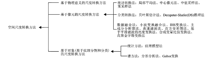
本文根据国内外已有的研究成果,系统的梳理了当前主要的空间尺度转换方法(图1),并重点阐述其中常用的统计转换法、分类转换法、数据融合转换方法、分形分析法、基于局域动态模型的转换方法和基于物理意义尺度转换方法。
图1 空间尺度转换方法示意
Fig.1 The mainly methodology of spatial scale transformation in quantitative remote sensing
统计转换方法主要指以遥感数据的像元亮度值(Digital Number, DN)为尺度转换的基础和依据,应用数理统计回归分析,通过建立某一特征量,如归一化植被指数NDVI(Normalized Difference Vegetation Index, NDVI),差值植被指数(Difference Vegetation Index, DVI),归一化水体指数(Normalized Difference Water Index, NDWI)等光谱指数在不同分辨率遥感影像之间的函数关系,从而由高空间分辨率遥感影像上获得的参数或变量的平均值推算出低空间分辨率遥感影像的参数或变量的平均特征,以此实现不同空间分辨率遥感影像之间的尺度转换。其中,先利用遥感影像计算光谱指数,再进行空间尺度上推的方法称为“分布式”,而先基于遥感影像进行空间尺度上推,再计算光谱指数的方法称为“聚合式”[22]。统计转换方法主要包括:局部平均法[23]、中心像元法[24]、中值采样法[25]和重采样方法[26,27](表1),其主要优点在于无需明晰遥感信息的物理机理,而是单纯从数据的角度出发用于遥感信息的尺度转换。
表1 基于统计的遥感尺度转换方法
Table 1 Scale transformation method in remote sensing based on statistics
| 方法名称 | 定义 | 优点 | 缺点 |
|---|---|---|---|
| (1)局部平均法[23] | 将高分辨率遥感影像中一定大小窗口内的像元合并,以其平均值作为合并后像元的值,通过计算所有窗口来获取转换后的较低分辨率影像 | 够较好地保持影像均值信息,且运算简单 | 易丢失部分细节信息 |
| (2)中心像元法[24] | 将高分辨率遥感影像中一定大小窗口内中心像元的值作为新像元的值,通过计算所有窗口来获取转换后的较低分辨率影像 | 方法简单易行,能够在一定程度上保持原影像的纹理特征 | 转换后的图像质量较差,且在窗口较大的情况下接近于随机图像 |
| (3)中值采样法[25] | 将高分辨率遥感影像中一定大小窗口内所有像元值的中位数值作为新像元的值,通过计算所有窗口来获取转换后的较低分辨率影像 | 该方法运算量小,能够较好地保持原图像的均值 | 尺度转换过程中信息损失量大,像元值不连续的问题 |
| (4)重采样法[26] ① 最近邻法 | 将高分辨率遥感影像中一定大小窗口内离采样点最近的像元值赋予转换后低分辨率影像所对应的像元值 | 算法简单、易实现 | 没有考虑除最近像元点以外的其它点,因而图像质量易受损失,像元不连续,且转换后的图像人为加工痕迹较明显 |
| ② 双线性内插法 | 将高分辨率遥感影像中2个正交方向上的像元值,按照先水平方向后垂直方向的顺序进行一阶线性插值,通过加权平均作为转换后较低分辨率影像中对应点的新像元值。 | 能够克服最近邻法的不足,避免转换后图像像元的不连续 | 运算量较大,转换精度不高、图像边缘信息易丢失 |
| ③ 无重叠平均法 | 将高分辨率遥感影像中无重叠方形窗口内的像元平均值赋予转换后低分辨率影像所对应的像元值 | Hay等[27]认为该方法的转换效果较好,而最近邻法、双线性内插法和立方卷积内插法在转换尺度超过5个像元时,不适用于遥感影像的尺度上推,转换可信度低 | 当影像中涉及大量复杂地物时,尺度转换精度不高 |
| ④ 立方卷积内插法 | 与双线性内插法原理相似,将高分辨率影像中的某像元周边的4个像元值改为16个进行加权平均,通过转换得到较低分辨率影像中对应点的新像元值 | 计算精度较高,考虑了相邻像元间的灰度值和其间的变化率,影像的边缘信息和纹理得到较好地保留 | 计算量大 |
分类转换就是针对不同分辨率的遥感数据进行地表分类,在分析各自特征影像的基础上,实现不同地物类型的空间尺度转换。其主要方法包括:贝叶斯估计法和Dempster-Shafer (DS)推理法等[21]。贝叶斯估计法的基本思路是在对不同尺度的遥感数据进行相容性分析的基础上,保留下可信度高的有用信息,剔除错误信息,利用样本信息和先验信息合成为后验分布,为求得目标数据最优的融合概率,对检测目标应用贝叶斯估计以此实现目标的识别决策[28]。该方法的优点在于在各个尺度遥感数据呈正态分布的情况下能获得最小的分类误差,而不足之处在于无法解决遥感影像的同物异谱和同谱异物的问题。此外,贝叶斯估计法的计算复杂度高、对细节信息保持能力较差[29]。DS推理法则是在20世纪70年代初由Dempster和Shafer师生二人共同在贝叶斯理论的基础上提出的,被称作是广义的贝叶斯估计法[30]。二者之间的区别在于前者对未知特征不赋予先验概率,而后者则相反。DS推理法通过构造无知函数、确认函数和概率函数将数理统计中的发生时间变为命题,同时赋予每个命题一个信任度以此代替先验概率,而基本概率分布函数则是通过提取不同尺度数据的特征参数来构造。该方法的应用领域从早期的人工智能逐步发展到遥感图像分类及尺度转换[31],其优势在于可以避免错误的数据分布假设,弥补传统方法要求数据必须服从正态分布的不足,还可以根据实际掌握的知识程度,清晰的表达数据融合过程中的不确定性。不足之处在于缺乏完善的数学基础做支撑,证据理论的使用范围受到组合规则要求的证据独立性条件的限制,证据本身存在的矛盾也会被组合规则的正规化过程所掩盖[21]。
随着遥感卫星数据产品的增多,不同空间尺度遥感数据之间的融合转换已成为遥感领域的关键技术。其实质在于:通过一定的算法,将低空间分辨率遥感影像融入到高空间分辨率遥感影像中,实现数据互补并消除数据冗余,以此提高影像的空间分辨率并达到尺度转换的目的[32]。当前应用较多的方法主要有小波变换融合法、IHS变换法、主成分分析算法、高通滤波法等。
小波变换融合法(Wavelet Decomposition, WD)的基本思路是将待融合的遥感影像通过小波变换分解成多级小波系数图像,同时将图像的频率信息分为体现光谱信息和结构特征的低频部分,以及体现空间信息和细节特征的高频部分,然后将每一级图像的高频部分和低频部分进行融合处理,再综合各级图像的融合结果进行重建从而得到转换后的图像[33]。该方法的优点是既可以保持图像的光谱特征,又能保留高分辨率影像的信息。不足之处在于:高分辨率影像的低频部分直接被低分辨率影像的低频部分替换,易损失高分辨率影像的细节信息,并产生明显的分块效应[34]。随着近年来小波理论的不断发展,基于小波变换方法的新算法不断涌现[35,36]。IHS变换法是将低分辨率的多光谱遥感影像经变换得到亮度(Intensity, I)、色调(Hue, H)和饱和度(Saturation, S)3个分量,然后保持H和S两个分量不变,将高分辨率的全色影像代替I分量,通过IHS空间逆变换得到新的高空间分辨率图像。该方法的优点在于既增强了影像的空间细节表现力,又保留了影像的光谱特征,同时还提高了影像的地物纹理特征,且操作简单,适用于不同分辨率影像的尺度转换。缺点在于转换易造成光谱信息失真,且处理的多光谱影像波段数必须为3[37]。
主成分分析算法(Principal Component Analysis, PCA)的提出就是由于遥感影像各个波段之间有很高的相关性,而其中相当一部分有用信息是重复和多余的。因此,PCA算法的目的就是尽可能的去除转换前低分辨率影像的冗余信息,通过特征提取和数据压缩,用变换后的高分辨率影像作为第一主成分量,再经过主成分逆变换得到转换后的影像。PCA算法的优点在于对于尺度不同,但成像机理相同的影像融合效果较好[38]。缺点是对成像机理不同的影像,在转换过程中会丢失大量光谱信息,从而导致转换后图像的光谱畸变严重[39]。
高通滤波法(High Pass Filtering, HPF)是一种将高频信息从高分辨率影像叠加到低分辨率影像的方法。按照叠加方式的不同又分为加权和不加权两种方法[40]。不加权方法是采用空间高通滤波器对高分辨率影像进行滤波,直接将高频信息进行叠加,以此获得空间分辨率增强的影像。其优点在于通过信息叠加,实现不同尺度影像的有效转换和融合,同时还具有一定的去噪功能;加权方法又称为高频调制融合法,主要通过空间配准,将不同分辨率影像进行相乘后得到的高分影像进行滤波处理、归一化处理后,将高频信息叠加到低分辨率影像上。该方法的优点在于可以有效保留影像的光谱信息,且对转换影像没有波段限制。总体上,滤波器的选择和构建是转换效果的关键。
分形理论是基于数学方法提出的一种非线性科学方法,并与孤波、混沌一起被称为非线性科学研究的前沿,在遥感尺度转换和改进影像空间方面具有很大的潜力。Xia和Clarke[41]基于分形方法开展了地形模拟研究,认为分形理论及其方法是当前遥感影像尺度转换的先进方法。徐希孺[42]认为以分形分析法为代表的数学方法是当前促进定量遥感理论体系建立,解决定量遥感问题的有效手段。其中,分维数是分形是反映特征空间分布变化、复杂程度和趋势的一个重要指标[43]。这是由于在遥感的研究对象——自然界中,许多现象和物体都具有统计自相关性,其结构特征只是会随着研究对象空间尺度变化而缩小或放大,整体为局部的无穷嵌套。遥感影像的分维数等于地面空间三维表面体在二维表面投影,也就是二维影像的灰度表面的分维法向向量,因而可以有效反映地面真实表面的分形特征。大量研究表明,遥感影像的分形分析能定量表达图像的信息量和空间复杂性。一方面,遥感影像能够真实记录地球表面的地物信息,而地球表面易形成形态多变且粗糙不平的复杂景观,这既是受随机因素的影响,也是分形表现的例证。另一方面,具有分形特征的表面与遥感接收的电磁波信息相互作用后的回波信号也具有部分反射面的分形特征。因此,不同尺度遥感影像能够根据分形的测量来进行比较和评价,从而实现遥感信息的尺度转换。
张娜从生态学的角度,总结了局域动态模型在生态学领域尺度转换的应用[44]。局域动态模型在遥感领域的应用主要通过选择基于该模型的尺度转换方法,并通过遥感影像反演的生态学变量进行尺度转换。在转换过程中,由于形成机制或主导过程的变化,因而易造成小尺度过程模型的实效,这就需要修正局域模型,或建立大尺度过程模型。当前常用的基于局域动态模型的转换方法包括:简单聚合法、显示积分法、期望外推法和直接外推法等[45](表2)。
表2 基于局域动态模型的尺度转换方法
Table 2 Scale transformation method based on local dynamic model in remote sensing
| 方法名称 | 定义 | 优点 | 缺点 |
|---|---|---|---|
| 简单聚合法 | 通过同时增加不同遥感影像的空间分辨率,将较高分辨率影像的参数或变量的平均值转换为较低分辨率影像 | 方法简单,容易实现 | 忽略了变量或参数在遥感影像尺度变化时发生的非线性变化,误差较大 |
| 显示积分法 | 要求高分辨率影像模型在空间上能够积分,是空间显示的数学函数,通过显示积分进行尺度转换,已连续函数表示空间异质性 | 计算复杂度较期望外推法和直接外推法有所降低,且在理论上是一种有效和精确的方法 | 以连续函数形式表达空间异质性的难度较大,方法尚待进一步完善,因而限制了该方法的推广应用 |
| 期望外推法 | 通过高分辨率影像模型按照地物类别的不同进行模拟,并根据结果计算较低空间分辨率影像的空间结构特征期望值与影像面积相乘,以此实现尺度转换 | 是当前较为通用的一种方法。通过蒙特卡罗模拟法估算得出的期望值,经得起不确定性分析 | 转换结果的准确性易受类别现象描述的准确性或空间变异性的影响 |
| 直接外推法 | 将局部分析模型从高分辨率影像应用到适合该模型的所有区域,通过计算不同地物的像素输出综合,实现尺度转换 | 计算方法简单直接,概念明晰,应用推广度最好 | 尺度转换的准确性易受到影像尺度转换过程中的误差积累影响 |
李小文等认为不同尺度之间存在“尺不变”的关系,即观测对象的过程和格局不会随着遥感数据尺度变化而变化,反之则称之为具有“尺度依赖性”[46]。一些学者基于物理、生物机理的融合影像因子尺度校正的“尺不变”模型。代表性研究如: Li和Wan[47],Albert等[48],Becker和Li[49]探讨了Helmholtz互易原理、Beer定律、Planck定律等物理学定律和原理在遥感像元尺度上的适用性。针对类似研究,栾海军等[50]做过较为详细的综述,这里就不再赘述。
时间尺度一般指年、月、旬、日、小时、瞬时等。基于遥感影像获取的地表下垫面信息为卫星过境时刻的瞬时值,在时间上是不连续的,因而难以满足不同研究对象对于特定时间尺度的需要,亟待将遥感反演得到的瞬时值进行时间尺度扩展。当前,地表蒸散发和农业旱情监测是当前遥感影像时间尺度转换应用最为广泛的2个主要研究领域,本研究重点从上述2个领域对时间尺度扩展方法进行总结。
蒸散发(Evapotranspiration, ET)作为陆面过程研究的关键参数和地面能量与水量平衡的重要组成部分,对于深入开展全球气候变化、水循环及水文过程、生态环境变化等相关研究工作具有重要的现实意义[51]。遥感技术因其能克服单点观测方法的不足,目前已成为模拟区域尺度地表ET最为主要的途径。基于遥感影像所获得的ET资料,为不同区域尺度范围卫星过境的瞬时数据,因而亟待将遥感数据进行时间尺度扩展,将瞬时尺度的数据转换为更有实际应用价值的日、旬、月、年等长时间序列数据,以满足ET研究的需要[52]。目前常见的时间尺度扩展方法主要有蒸发比法[53,54]、作物系数法[55,56]、冠层阻力法[57,58]和正弦关系法[59](表3)。
表3 常见的地表遥感蒸散发时间尺度转换方法对比
Table 3 Temporal transformation method for surface heat and water fluxes in remote sensing
| 方法名称 | 定义 | 优点 | 缺点 |
|---|---|---|---|
| 蒸发比法[53,54] | 在云量保持恒定或晴朗的白天,由于正午瞬时蒸发比近似日均蒸发比,以此建立基于蒸发比的尺度转换模型,实现区域ET的估算 | 方法简易,且较为常用 | 在实际应用中误差较大,需要进一步改进,并校正偏差,提高精度 |
| 作物系数法[55,56] | 由于实际ET与作物ET比值(作物系数)在日内变化较小,因而主要由联合国粮农组织提供的基于作物系数的时间尺度扩展方法,将遥感影像所获取的瞬时作物系数代替日作物系数,实现由瞬时 ET 到日的时间尺度扩展 | 在地表植被均匀的情况下,所得到的结果精度较高 | 在作物生育中后期,该方法所确定的作物系数与实测值有较大误差,必须进行参数调校,才能提高精度 |
| 冠层阻力法[57,58] | 以蒸散发估算最为有效,应用最为广泛的Penman-Monteith模型为基础,采用遥感瞬时数据估算模型中的下垫面、通量数据等相关参数,进而推导出卫星过境时刻的冠层阻力。据此,估算不同时间尺度区域ET值 | 大量研究结果表明,该方法可以有效实现大区域尺度,长时间序列ET数据的扩展 | 易受遥感数据及模型局限性的限制,估算结果的变异性较大 |
| 正弦关系法[59] | 太阳辐射在日尺度范围内呈现周期性变化。在晴朗的天气条件下,卫星过境时获取的瞬时辐射与日内辐射间存在正弦曲线关系,其比值可用于瞬时ET与日ET比值的替换,以此实现ET的时间尺度扩展 | 简单易用,便于理解,在天气晴朗的条件下,具有较好的可行性,结果精度较高 | 扩展后的日ET数值易受复杂天气和地面条件的影响,与实测数值日ET数值相比有所偏离 |
如表3所示,地表遥感蒸散发时间尺度转换方法存在的问题主要包括以下2个方面:一是时间尺度转换的不确定性较大。突出表现在遥感观测信息受地表状态、气象条件、辐射状况以及遥感传感器本身等因素的制约,难以实现区域ET的精准观测[60]。二是不同时间尺度转换方法其本身具有一定的不确定性,适用性差异较大。主要表现为不同方法对区域下垫面类型、气候条件的要求各异,方法本身的不确定性较大,相同方法在不同气候和下垫面条件下的模拟结果具有较大差异[61]。
农业旱情的发生、作物水分的亏缺是一个时间累积的过程,由于不同作物的生育期不同,不同生育期发生旱情对作物的产量影响亦不相同。因而亟待将遥感数据所获取的瞬时尺度旱情信息进行时间尺度转换,获取不同农作物关键生育时期的农业旱情监测信息,提高旱情评估精度。陈素华等[61]将作物受灾敏感值进行时间尺度转换,以此确定了内蒙古作物春播期、生长期、生育期和成熟期等4个关键时期旱情对作物减产量之间的关系,并建立了区域粮食产量旱情损失量评估模型,有效开展了内蒙古赤峰市粮食产量评估。Bayarjargal等[62]运用最大值合成法将月尺度遥感数据转换为植物生长季(4~9月)的农业旱情监测产品以监测农业旱情的时空变化。Tian等[63]基于MODIS数据构建了旬尺度条件植被温度指数(Vegetation Temperature Condition Index)用于中国关中平原冬小麦旱情监测。王蕾等[64]在此基础上提出对基于遥感数据获取的不同生育期旱情监测信息进行时间尺度转换的关键在于确定不同时期旱情的发生对农作物产量影响的权重系数。目前,常见的赋权方法主要包括以下3种:一是以层次分析法、专家调查法、因子权重排序法、特征值法为代表的主观赋权法。其优点在于解释性较强,缺点在于主观性和随意性较大[65]。二是以熵值法、变异系数法、主成分分析法、灰色关联法为代表的客观赋权法。其优点在于有较好的数据基础,不受人为因素的影响,缺点在于完全忽略了决策者的经验知识,容易导致赋权结果与实际情况出入较大[64]。三是综合主客观赋权方法的组合赋权法。其优势在于能够将数学方法和专家决策相结合,有效规避主、客观赋权法的不足,提高应用精度[66]。白雪娇等[67]在此基础上,尝试分别利用遗传算法、穷举法以及熵值法与因子权重排序法相结合的归一组合赋权法开展了关中平原冬小麦关键生育时期的遥感旱情监测指数的时间尺度扩展研究。研究结果表明,利用遗传算法获取的加权农业旱情监测指数所估测的区域单产精度较高,是该区域多时相遥感监测数据时间尺度转换的最佳方法。
本研究在厘清气象、水文、生态、地理等不同学科所涉及的尺度转换概念及方法的基础上,系统总结了当前遥感科学在空间尺度和时间尺度上的主要转换方法,重点比较分析了以统计转换法、分类转换法、数据融合转换方法、分形分析法、基于局域动态模型的转换方法和基于物理意义尺度转换方法等6种方法为代表的空间尺度转换方法,以及地表遥感蒸散发和农业旱情监测领域所涉及的时间尺度转换方法所包含的每种方法的优势与不足。研究结果表明,目前国内外在尺度效应和尺度转换研究方面所取得的成果较30 a前尺度问题刚提出时已取得较大突破,但在实际应用过程中还存在很大的发展提升空间。例如,应进一步加强地面遥感观测实验,以此获取不同时空尺度遥感数据与地面观测数据从而支持尺度转换研究。李新等[68]为此详细论述了在中国2012年启动的黑河生态水文遥感实验中关于进一步推进尺度转换问题研究所做的尝试以及在发展普适性尺度转换方法等方面取得的进展。此外,如何参考李小文院士[6]所提出的“自下而上归纳方法和自上而下的演绎方法”的思路,建立统一、严谨的定量遥感尺度转换理论,融合多学科交叉知识,推进尺度研究进一步向深层次迈进,始终是未来需要进一步研究的方向。最后,从最新国内外研究进展来看,进一步挖掘基于数学方法提出的分形理论在遥感尺度转换方面所具有的潜力,提高分形理论及其方法在尺度转换中的应用,从而构建具有较强普适性的遥感时空尺度转换方法亦是今后研究的热点方向之一。
The authors have declared that no competing interests exist.
| [1] |
地理空间数据的尺度转换 [J].https://doi.org/10.11867/j.issn.1001-8166.2013.03.0297 URL [本文引用: 1] 摘要
尺度一般是指空间范围的大小,地理空间数据的尺度转换是尺度研究的重要问题之一。针对地理信息系统(GIS)技术支持下的地理空间数据尺度转换问题,首先回顾了尺度转换的理论基础,即等级理论、分形理论、区域化随机变量理论、地理学第一定律等理论的基本内涵;然后总结了地理学不同研究领域内主要的尺度转换方法,重点分析了重采样法、变异函数法、分形分维法及小波分析法的基本原理、模型方法与典型应用案例;最后介绍了地理空间数据尺度转换效应研究的进展。基于上述总结和分析认为:构建一套无级变换的、系统的尺度转换方法,整合不同学科领域的数据与过程模型、形成数据模型同化的技术体系,这是地理空间数据尺度转换研究的重要课题。
A review of the scaling issues of geospatial data .https://doi.org/10.11867/j.issn.1001-8166.2013.03.0297 URL [本文引用: 1] 摘要
尺度一般是指空间范围的大小,地理空间数据的尺度转换是尺度研究的重要问题之一。针对地理信息系统(GIS)技术支持下的地理空间数据尺度转换问题,首先回顾了尺度转换的理论基础,即等级理论、分形理论、区域化随机变量理论、地理学第一定律等理论的基本内涵;然后总结了地理学不同研究领域内主要的尺度转换方法,重点分析了重采样法、变异函数法、分形分维法及小波分析法的基本原理、模型方法与典型应用案例;最后介绍了地理空间数据尺度转换效应研究的进展。基于上述总结和分析认为:构建一套无级变换的、系统的尺度转换方法,整合不同学科领域的数据与过程模型、形成数据模型同化的技术体系,这是地理空间数据尺度转换研究的重要课题。
|
| [2] |
A semantic-rich multi-scale information model for topography [J].https://doi.org/10.1080/13658816.2010.490218 URL [本文引用: 1] 摘要
National mapping agencies maintain topographic data sets at different scales. Keeping the data sets consistent, for example by means of automated update propagation, requires formal knowledge on how the different data sets relate to each other. This article presents a multi-scale information model that, first, integrates the data states at the different scales and, second, formalises semantics on scale transitions. This is expressed using the Unified Modelling Language (UML) class diagrams, complemented with Object Constraint Language (OCL). Based on a requirement analysis using the needs of the Netherlands' Kadaster as case study, this article examines several modelling alternatives and selects the optimal modelling approach for a multi-scale information model for topography. The model is evaluated through a prototype database implementation. The results show that UML/OCL provides an appropriate formalism to model rich semantics on both multi-scale data content and scale transitions, which can be used for guarding consistency based on automated generalisation of updates. Further research is required to express generalisation specifications that are currently not formalised and that are only available in software code or as cartographers' knowledge.
|
| [3] |
The heterogeneous multiscale metho [J].https://doi.org/10.1017/S0962492912000025 URL [本文引用: 1] 摘要
The heterogeneous multiscale method (HMM), a general framework for designing multiscale algorithms, is reviewed. Emphasis is given to the error analysis that comes naturally with the framework. Examples of finite element and finite difference HMM are presented. Applications to dynamical systems and stochastic simulation algorithms with multiple time scales, spall fracture and heat conduction in microprocessors are discussed.
|
| [4] |
遥感影像空间尺度特征与最佳空间分辨率选择 [J].https://doi.org/10.3321/j.issn:1007-4619.2008.04.001 URL Magsci [本文引用: 1] 摘要
尺度概念是理解地球系统复杂性的关键,尺度问题被认为是对地观测的主要挑战之一,而结合具体研究应用领域,由地学现象的尺度本身出发,选择所需遥感影像的最佳尺度和分辨率,是非常有现实意义的.本文在深入剖析了遥感影像的尺度特性和遥感影像尺度选择的意义的基础上,探讨了基于地统计学方法定量选择遥感影像最佳空间分辨率的方法.阐明了传统局部方差方法不能得到理想结果的原因:传统的局部方差方法的实质是基于变化地面面积计算影像局部方差的均值,而基于这样不同甚至是相差悬殊的地面面积进行局部方差计算,其结果必然不具有可比性.对此,本文提出了基于可变窗口与可变分辨率的改进局部方差方法,即依次降低空间分辨率时,高分辨率采用大窗口尺寸,低分辨率采用小窗口尺寸来维持计算窗口内的地面面积的一致,由此计算出的局部方差作比较来判定遥感影像最佳分辨率.进行了系列实验分析,得到了相关结论,分析得出这种基于地统计的方法来选择遥感影像最佳分辨率的方法,对遥感和GIS研究与地学应用具有一定的理论意义和指导意义.
Spatial scale of remote sensing image and selection of optimal spatial resolution .https://doi.org/10.3321/j.issn:1007-4619.2008.04.001 URL Magsci [本文引用: 1] 摘要
尺度概念是理解地球系统复杂性的关键,尺度问题被认为是对地观测的主要挑战之一,而结合具体研究应用领域,由地学现象的尺度本身出发,选择所需遥感影像的最佳尺度和分辨率,是非常有现实意义的.本文在深入剖析了遥感影像的尺度特性和遥感影像尺度选择的意义的基础上,探讨了基于地统计学方法定量选择遥感影像最佳空间分辨率的方法.阐明了传统局部方差方法不能得到理想结果的原因:传统的局部方差方法的实质是基于变化地面面积计算影像局部方差的均值,而基于这样不同甚至是相差悬殊的地面面积进行局部方差计算,其结果必然不具有可比性.对此,本文提出了基于可变窗口与可变分辨率的改进局部方差方法,即依次降低空间分辨率时,高分辨率采用大窗口尺寸,低分辨率采用小窗口尺寸来维持计算窗口内的地面面积的一致,由此计算出的局部方差作比较来判定遥感影像最佳分辨率.进行了系列实验分析,得到了相关结论,分析得出这种基于地统计的方法来选择遥感影像最佳分辨率的方法,对遥感和GIS研究与地学应用具有一定的理论意义和指导意义.
|
| [5] |
Impacts of remote sensing on U.S. geography [J].https://doi.org/10.1016/0034-4257(80)90098-x URL [本文引用: 1] 摘要
Examines some impacts of remote sensing on geography. As geographers involved in this new technology, the authors review and place in context its development; and with a vision of its value to their discipline, they are concerned at its modest impact on major research areas in geography. Even acknowledging that, in a broader view, remote sensing's impact on geography has been greater than in other disciplines does not alleviate their concerns that few senior academic geographers have remote sensing research underway; that few economic geographers have examined its potential; that even fewer regional geographers with interests in less-developed countries have remote sensing research interests; and that although there has been growth in the number of remote sensing courses taught in geography, this has not been accompanied by publication in reviewed geographic journals. The authors ask the questions: What does remote sensing permit the geographer to do better and/or cheaper than he or she could do in the past? What may remote sensing enable future geographers to do which would be significant to professional and academic geography?
|
| [6] |
定量遥感尺度效应刍议 [J].https://doi.org/10.11821/dlxb201309001 URL [本文引用: 2] 摘要
目前定量遥感在面向国家需求、面向基础研究方面,存在海量遥感数据无法有效利用、定量遥感研究缺乏普适性和系统性、遥感应用难以再上新台阶等主要问题。因此,目前的遥感科学研究需要整合,需要向前迈出一大步。由于地表的异质性,我们如果只停留在演绎普适的机理模型在特定地点作个性化的处理,是不能适合地学的应用和研究的。必须在已有的反演和实验数据的基础上,用归纳的方法,总结出一些规律性的东西。走我国自然地理学"自上而下的演绎方法和自下而上归纳方法的结合"研究"尺度综合"的路子,在解决遥感科学核心问题"尺度效应"方面先搭建一个方法框架,同时建立几个开放的相关平台(如数据,反演,计算机模拟,等等),与有关学科的专家共享。
Prospects on future developments of quantitative remote sensing .https://doi.org/10.11821/dlxb201309001 URL [本文引用: 2] 摘要
目前定量遥感在面向国家需求、面向基础研究方面,存在海量遥感数据无法有效利用、定量遥感研究缺乏普适性和系统性、遥感应用难以再上新台阶等主要问题。因此,目前的遥感科学研究需要整合,需要向前迈出一大步。由于地表的异质性,我们如果只停留在演绎普适的机理模型在特定地点作个性化的处理,是不能适合地学的应用和研究的。必须在已有的反演和实验数据的基础上,用归纳的方法,总结出一些规律性的东西。走我国自然地理学"自上而下的演绎方法和自下而上归纳方法的结合"研究"尺度综合"的路子,在解决遥感科学核心问题"尺度效应"方面先搭建一个方法框架,同时建立几个开放的相关平台(如数据,反演,计算机模拟,等等),与有关学科的专家共享。
|
| [7] |
Salt marsh vegetation radiometry: Data analysis and scaling [J].https://doi.org/10.1016/S0034-4257(01)00325-X URL [本文引用: 1] |
| [8] |
Ecological correlations and the behavior of individuals [J].https://doi.org/10.1093/ije/dyn357 URL PMID: 19179346 [本文引用: 1] 摘要
This paper aims to discuss the ecological correlation problem by stating mathematically the exact relation between ecological and individual correlations, and by showing the bearing of that relation upon the practice of using ecological correlations as substitutes for individual correlations. A specific example on the use of this method to describe the relationship between ethnicity and illiter...
|
| [9] |
Sensitivity of simulated climate to model resolution [J].https://doi.org/10.1175/1520-0442(1991)0042.0.CO;2 URL [本文引用: 1] 摘要
Abstract Dynamical measures of the climate (e.g., winds, eddy fluxes) simulated by a general circulation model are compared at different horizontal and vertical resolutions for the December, January, and February period. The simulations of the troposphere are found to improve significantly as the horizontal resolution increases in the range of spectral truncations from T21 to T63. Little sensitivity is found to changes in vertical resolution between about 2.8 km and 0.7 km vertical grid spacing. The improvements in the Southern Hemisphere troposphere are greater than in the Northern Hemisphere as the horizontal resolution increases. The eddy momentum fluxes and kinetic energies in both hemispheres increase monotonically with horizontal resolution. At T63, the Southern Hemisphere winds, eddy fluxes, and eddy kinetic energies agree favorably with observations, while serious discrepancies are present at lower resolutions. In the Northern Hemisphere, the eddy momentum flux at T63 is slightly larger than obser...
|
| [10] |
Sensitivity of dynamical quantities to horizontal resolution for a climate simulation using the ECMWF(Cycle33) Model [J].https://doi.org/10.1175/1520-0442(1993)0062.0.CO;2 URL [本文引用: 1] 摘要
Abstract The European Centre for Medium-Range Weather Forecasts (ECMWF) model (cycle 33) was integrated for a full seasonal cycle at four horizontal resolutions, T21, T42, T63, and T106. Within the limits imposed by the varying horizontal resolution all other aspects of the model were identical for each integration. In this paper a comparison is made of the dynamical aspects of the simulations. Fields of zonally averaged zonal wind, eddy heat and momentum fluxes, global divergent wind and vorticity, and stationary wave patterns are presented and compared for each resolution. The conclusions reached by this study are (i) T21 is qualitatively different from the higher resolutions; (ii) the highest resolution does not provide a simulation that is egregiously superior to T42. There are aspects of the T21 simulation, especially in tropical convection, that are clearly better than the higher resolutions; (iii) aside from differences in smaller-scale boundary forcing at the higher resolutions, the T42. T63, T106...
|
| [11] |
Statistical downscaling of daily precipitation over Greece [J].https://doi.org/10.1002/joc.1557 URL [本文引用: 1] 摘要
The capability of a multi-site non-homogeneous hidden Markov model (NHMM) to downscale winter daily precipitation over Greece is explored for the period 1971-2000. The input variables were selected from NCEP Reanalysis Data following an optimization procedure and include the precipitation rate as predictor. The most parsimonious NHMM identified five weather states. Successively, the forecast skill of the model was tested against sequentially withdrawn data. The NHMM reproduced successfully both the station-scale statistics like the occurrence and amount of precipitation as well as the spatial pattern of precipitation such as the correlations between stations and the Log-Odds ratios. Also, the temporal correlation in the data at most of the rain gauges was successfully captured at seasonal timescales. Finally, the model was capable of reproducing extreme precipitation events. It modelled successfully the dry spells as well as most of the indices corresponding to very wet events, including the maximum 5-day precipitation amount, the number of extreme precipitation events and their corresponding fraction of the total precipitation amount, better to the stations where the very wet events are not associated with local scale features that could not be captured by the large-scale predictors. The weakest reproduced indices correspond to the mean wet day precipitation and the 90th percentile of precipitation on wet days where the model captured their magnitude but not their interannual variability. Copyright 2007 Royal Meteorological Society
|
| [12] |
Scale issues in hydrological modelling: a review [J].https://doi.org/10.1002/hyp.3360090305 URL [本文引用: 1] |
| [13] |
水文尺度转换探讨 [J].
水文尺度问题是当今水文学研究的热点和前沿.水文尺度包括过程尺度、观测尺度和模拟尺度三方面含义.主导过程尺度作为尺度的特征量,是水文研究中的重点.水文尺度转换工作包括了对水文模式、参数、状态变量和输入的尺度转换四方面,每一方面都有其特殊的研究方法.水文系统的有组织复杂性、时空变异性和数据不足是当前水文研究的难点所在.自然河网的自相似特性使其成为水文尺度研究的重要组成部分.进一步深入研究水文尺度问题需要多种研究思路、技术手段和理论工具的结合.
Discussion on hydrological scaling .
水文尺度问题是当今水文学研究的热点和前沿.水文尺度包括过程尺度、观测尺度和模拟尺度三方面含义.主导过程尺度作为尺度的特征量,是水文研究中的重点.水文尺度转换工作包括了对水文模式、参数、状态变量和输入的尺度转换四方面,每一方面都有其特殊的研究方法.水文系统的有组织复杂性、时空变异性和数据不足是当前水文研究的难点所在.自然河网的自相似特性使其成为水文尺度研究的重要组成部分.进一步深入研究水文尺度问题需要多种研究思路、技术手段和理论工具的结合.
|
| [14] |
Scaling and uncertainty analysis in ecology [M]. |
| [15] |
生态学中的尺度问题 [J].
尺度推绎是生态学理论和应用的核心。如何在一个异质景观中进行尺度推绎仍然是一个悬而未决的科学难题,是对当今生态学家在全球变化背景下研究环境问题的重大挑战。就目前的研究,一般可分为四大类尺度推绎途径:空间分析法(如分维分析法和小波分析法)、基于相似性的尺度上推方法、基于局域动态模型的尺度上推方法、随机(模型)法。基于相似性的尺度上推方法来源于生物学上的异量关联,可将其思想延伸至空间上,研究物种丰富度、自然河网、地形特征、生态学格局或过程变量和景观指数等。基于局域动态模型的尺度上推方法需要首先确定是否进行跨尺度推绎,以及是否考虑空间单元之间的水平相互作用和反馈,然后再应用具体的方法或途径,如简单聚合法、有效值外推法、直接外推法、期望值外推、显式积分法和空间相互作用模拟法等。随机(模型)法以其它尺度上推方法为基础,根据研究的是单个景观,还是多个景观,采用不同的途径。理解、定量和降低尺度推绎结果的不确定性已经变得越来越重要,但相关研究仍然极少。以上所有有关尺度推绎的方法、途径和结果分析共同构成了尺度推绎的概念框架。
Scale issues in ecology: Upscaling .
尺度推绎是生态学理论和应用的核心。如何在一个异质景观中进行尺度推绎仍然是一个悬而未决的科学难题,是对当今生态学家在全球变化背景下研究环境问题的重大挑战。就目前的研究,一般可分为四大类尺度推绎途径:空间分析法(如分维分析法和小波分析法)、基于相似性的尺度上推方法、基于局域动态模型的尺度上推方法、随机(模型)法。基于相似性的尺度上推方法来源于生物学上的异量关联,可将其思想延伸至空间上,研究物种丰富度、自然河网、地形特征、生态学格局或过程变量和景观指数等。基于局域动态模型的尺度上推方法需要首先确定是否进行跨尺度推绎,以及是否考虑空间单元之间的水平相互作用和反馈,然后再应用具体的方法或途径,如简单聚合法、有效值外推法、直接外推法、期望值外推、显式积分法和空间相互作用模拟法等。随机(模型)法以其它尺度上推方法为基础,根据研究的是单个景观,还是多个景观,采用不同的途径。理解、定量和降低尺度推绎结果的不确定性已经变得越来越重要,但相关研究仍然极少。以上所有有关尺度推绎的方法、途径和结果分析共同构成了尺度推绎的概念框架。
|
| [16] |
The Irish national electrification scheme [J].https://doi.org/10.2307/211864 URL [本文引用: 1] 摘要
Two aqueous suspensions, one containing crystals of uniform size and the other containing colloidal particles, were made with each of seven solid contact poisons (two DDT-analogues, DDT, rotenone, 2-bromomercurithiophen, dieldrin and endrin). The relative toxicity of each pair of suspensions was found in dipping or measured-drop tests on as many as possible of the species Oryzaephilus surinamennsis L., Tribolium castaneum Herbst and Tenebrio molitor L. In addition, some tests were made by injection of colloidal suspensions. In each test, insects were kept after treatment at two temperatures: 28 degrees C. and 11, 17 or 20 degrees C.; counts of kill were made after 24 hr. The tests measured three different kinds of temperature coefficient of insecticidal action. In the contact tests, the colloid was nearly always more toxic than the crystals. In all the tests, except those with dieldrin, the relative toxicity (colloid : crystals) was greater at the lower after-treatment temperature, i.e. the temperature coeficient of the relative toxicity was negative. But in the case of dieldrin, the coefficient was positive. The DDT-analogues, DDT, rotenone and endrin were more toxic at the lower after-treatment temperature, i.e. they had negative temperature coefficients of kill by contact action. In all these cases the temperature coefficient of kill by contact action was greater for colloid than for crystals. Dieldrin and 2-bromomercurithiophen had positive temperature coefficients of kill by contact action. With dieldrin, the temperature coefficient was greater for colloid than for crystals; but with 2-bromomercurithiophen, the reverse was true. The temperature coeficient of kill by injection was negative for DDT, but positive for dieldrin and endrin; the other poisons were not tested by injection. A possible explanation for the results of the contact tests is given in an Appendix. The explanation is based on a number of assumptions about the penetration of insect cuticle by solid poisons. These assumptions lead to the conclusion that the effect of temperature on the relative toxicity depends on the temperature coefficient of kill by internal action of the poison on the insect. This can be measured by injection tests. If it is negative or zero, the ratio of toxicities (colloid: crystals) by contact action, measured quite soon after treatment of the insects, will be greater at a low temperature after treatment than at a high temperature after treatment; but if the coefficient is positive, the effect of temperature on relative toxicity cannot be foretold. The experimental results seem to confirm the assumptions.
|
| [17] |
Ecological fallacies and the analysis of the areal census data [J].https://doi.org/10.1068/a160017 URL PMID: 12265900 [本文引用: 1] 摘要
Abstract The author examines problems related to the fact that in many countries, census data are only reported for areal units and not at the individual level. Attention is paid to the question of ecological fallacy problems that arise from this situation. Data from a 10 percent sample of the United Kingdom population and individual census data from Italy are used to illustrate the problem. "It is concluded that ecological fallacy effects are endemic to areal census data, although their magnitude is perhaps not as large as might have been expected. The principal difficulty is that there is at present no way of predicting in advance the degree of severity likely to be associated with particular variables and particular techniques. Finally, a suggestion is made concerning how the potentially serious practical consequences can be reduced." excerpt
|
| [18] |
Understanding the scale and resolution effects in remote sensing and GIS [M]. |
| [19] |
Upscaling and downscaling methods for environmental research [M]. |
| [20] |
The factor of scale in remote sensing [J].https://doi.org/10.1016/0034-4257(87)90015-0 URL [本文引用: 1] 摘要
Thanks to such second- and third-generation sensor systems as Thematic Mapper, SPOT, and AVHRR, a user of digital satellite imagery for remote sensing of the earth's surface now has a choice of image scales ranging from 10 m to 1 km. The choice of an appropriate scale, or spatial resolution, for a particular application depends on several factors. These include the information desired about the ground scene, the analysis methods to be used to extract the information, and the spatial structure of the scene itself. A graph showing how the local variance of a digital image for a scene changes as the resolution-cell size changes can help in selecting an appropriate image scale. Such graphs are obtained by imaging the scene at fine resolution and then collapsing the image to successively coarser resolutions while calculating a measure of local variance. The local variance/resolution graphs for the forested, agricultural, and urban/suburban environments examined in this paper reveal the spatial structure of each type of scene, which is a function of the sizes and spatial relationships of the objects the scene contains. At the spatial resolutions of SPOT and Thematic Mapper imagery, local image variance is relatively high for forested and urban/suburban environments, suggesting that information-extracting techniques utilizing texture, context, and mixture modeling are appropriate for these sensor systems. In agricultural environments, local variance is low, and the more traditional classifiers are appropriate.
|
| [21] |
遥感尺度转换研究进展 [J].https://doi.org/10.3969/j.issn.1672-0504.2004.05.002 URL [本文引用: 3] 摘要
造成遥感问题复杂化的重要原因之一就是不同遥感测量方式获取的数据及地面测量数据在尺度上的不一致.在应用不同尺度的遥感数据时,尺度转换显得格外重要.该文阐述了遥感尺度转换所解决的问题,并针对国内外研究现状,分别论述基于像元和基于对象的遥感尺度转换的研究进展,对各种尺度转换方法的转换效果进行分析.最后对遥感尺度转换研究的发展趋势与前景进行展望.
Geography and Geo-Information Science, Geography and Geo- https://doi.org/10.3969/j.issn.1672-0504.2004.05.002 URL [本文引用: 3] 摘要
造成遥感问题复杂化的重要原因之一就是不同遥感测量方式获取的数据及地面测量数据在尺度上的不一致.在应用不同尺度的遥感数据时,尺度转换显得格外重要.该文阐述了遥感尺度转换所解决的问题,并针对国内外研究现状,分别论述基于像元和基于对象的遥感尺度转换的研究进展,对各种尺度转换方法的转换效果进行分析.最后对遥感尺度转换研究的发展趋势与前景进行展望.
|
| [22] |
Scale in remote sensing and GIS [M]. |
| [23] |
遥感影像尺度转换及最优尺度选择探讨 [J].https://doi.org/10.3969/j.issn.1672-0636.2011.02.006 URL [本文引用: 1] 摘要
从信息提取的角度阐述遥感影像尺度问题的重要性,评述了尺度效应、尺度转换以及最优尺度选择研究的国内、外现状。重点探讨几种不同尺度转换方法,以及基于像元和面向对象的最优尺度选择方法的技术特点,分析了尺度研究未来发展方向。
Review on scale transformation for remote sensing image and selection of optimal spatial resolution .https://doi.org/10.3969/j.issn.1672-0636.2011.02.006 URL [本文引用: 1] 摘要
从信息提取的角度阐述遥感影像尺度问题的重要性,评述了尺度效应、尺度转换以及最优尺度选择研究的国内、外现状。重点探讨几种不同尺度转换方法,以及基于像元和面向对象的最优尺度选择方法的技术特点,分析了尺度研究未来发展方向。
|
| [24] |
栅格数字地形分析中的尺度问题研究方法 [J].https://doi.org/10.11821/dlyj201402007 URL [本文引用: 1] 摘要
栅格数字高程模型(DEM)固有的尺度特征给以栅格DEM为基本输入的数字地形分析带来各种尺度问题。对栅格数字地形分析中涉及的尺度进行梳理,以分辨率和分析窗口为重点,对栅格数字地形分析中的多尺度表达、尺度效应、适宜尺度选择、尺度转换等尺度问题及其相互关系进行阐述;分别介绍各类尺度问题的现有定量研究方法,尤其对尺度效应定量刻画和适宜尺度选择方法,根据不同方法计算定量指标所利用的信息类别进行分类归纳;最后讨论了其中有待进一步开展研究的几方面工作。
Review on scale-related researches in grid-based digital terrain analysis .https://doi.org/10.11821/dlyj201402007 URL [本文引用: 1] 摘要
栅格数字高程模型(DEM)固有的尺度特征给以栅格DEM为基本输入的数字地形分析带来各种尺度问题。对栅格数字地形分析中涉及的尺度进行梳理,以分辨率和分析窗口为重点,对栅格数字地形分析中的多尺度表达、尺度效应、适宜尺度选择、尺度转换等尺度问题及其相互关系进行阐述;分别介绍各类尺度问题的现有定量研究方法,尤其对尺度效应定量刻画和适宜尺度选择方法,根据不同方法计算定量指标所利用的信息类别进行分类归纳;最后讨论了其中有待进一步开展研究的几方面工作。
|
| [25] |
Comparing effects of aggregation methods on statistical and spatial properties of simulated spatial data [J]. |
| [26] |
Quantitative remote sensing of land surfaces [M]. |
| [27] |
Spatial thresholds, image-objects, and upscaling: A multiscale evaluation [J].https://doi.org/10.1016/S0034-4257(97)81622-7 URL [本文引用: 1] 摘要
When examining a remotely sensed signal through various scale changes, what is the most appropriate upsealing technique to represent this signal at different scales? And how can this be validated? Solutions to these questions were approached by examining how the 660 nm signal of six forest stands vary through four different scales of same-.sensor imagery, four traditional resampling techniques, and a new object-specific resampling technique. Analysis of the original and modeled datasets suggests that appropriately upscaled imagery represents a more accurate scene-model than an image obtained at the upscaled resolution. Results further indicate the need for a multiscale approach to feature extraction and upscaling, as no single spatial resolution of imagery appears optimal for detecting or Upscaling the varying sized, shaped, and spatially distributed objects within a scene. By employing the human eye as a model, we describe a novel object-specific approach for addressing this challenge. Upscaling evaluation is based on visual interpretation, an understanding of the applied resampling theories, and the root mean square error results of 6000 samples collected from a 10 in CASI scene, and from 1.5 m, 3 in, and 5 m same site CASI images upscaled to 10 m. Potential application of this object-specific approach in hierarchical ecosystem modeling is also briefly described.
|
| [28] |
Spatial scaling between leaf area index maps of different resolutions [J].https://doi.org/10.1016/j.jenvman.2006.08.016 URL PMID: 17123700 [本文引用: 1] 摘要
We developed algorithms for spatial scaling of leaf area index (LAI) using sub-pixel information. The study area is located near Liping County, Guizhou Province, in China. Methods for LAI spatial scaling were investigated on LAI images with 960 m resolution derived in two ways. LAI from distributed calculation (LAID) was derived using Landsat ETM+ data (30 m), and LAI from lumped calculation (LAIL) was obtained from the coarse (960 m) resolution data derived through resampling the ETM+ data. We found that lumped calculations can be considerably biased compared to the distributed (ETM+) case, suggesting that global and regional LAI maps can be biased if surface heterogeneity within the mapping resolution is ignored. Based on these results, we developed algorithms for removing the biases in lumped LAI maps using sub-pixel land cover-type information, and applied these to correct one coarse resolution LAI product which greatly improved its accuracy.
|
| [29] |
|
| [30] |
An approach using Dempster-Shafer Theory to fuse spatial data and satellite image derived crown metrics for estimation of forest stand leading species [J].https://doi.org/10.1016/j.inffus.2012.05.004 URL [本文引用: 1] 摘要
Leading species at the forest stand level is a required forest inventory attribute. Information regarding leading species enables the calculation of volume and biomass in support of forest monitoring and reporting activities. In this study, approaches for leading species estimation based upon very high spatial resolution (pixel sided Among the data source combinations tested in the study, the QuickBird panchromatic combined with selected optical channels from Landsat-5 Thematic Mapper (TM) imagery provided the highest overall accuracy (70.4%) for identifying leading species and improved the accuracy by 3.1% over a baseline from a classification-tree based method applied on all data sources. Additional insights to the application of DST to fuse satellite imagery with ancillary data sources to map leading stand species in a boreal environment are also elaborated upon, including the range and distribution of training data and DST mass function establishment. (c) 2012 Elsevier B.V. All rights reserved.
|
| [31] |
A new technique for combining multiple classifiers using the Dempster-Shafer Theory of evidence [J].https://doi.org/10.1613/jair.1026 URL [本文引用: 1] 摘要
This paper presents a new classifier combination technique based on the Dempster-Shafer theory of evidence. The Dempster-Shafer theory of evidence is a powerful method for combining measures of evidence from different classifiers. However, since each of the available methods that estimates the evidence of classifiers has its own limitations, we propose here a new implementation which adapts to training data so that the overall mean square error is minimized. The proposed technique is shown to outperform most available classifier combination methods when tested on three different classification problems.
|
| [32] |
An IHS and wavelet integrated approach to improve pan-sharpening visual quality of natural color IKONOS and QuickBird images [J].https://doi.org/10.1016/j.inffus.2004.06.009 URL [本文引用: 1] 摘要
Image fusion is an important tool in remote sensing, as many Earth observation satellites provide both high-resolution panchromatic and low-resolution multispectral images. To date, many image fusion techniques have been developed. However, the available algorithms can hardly produce a satisfactory fusion result for IKONOS and QuickBird images. Among the existing fusion algorithms, the IHS technique is the most widely used one, and the wavelet fusion is the most frequently discussed one in recent publications because of its advantages over other fusion techniques. But the colour distortion of these two techniques is often obvious, especially when IKONOS or QuickBird natural colour multispectral images are fused with its panchromatic images. This study presents a new fusion approach that integrates the advantages of both the IHS and the wavelet techniques to reduce the colour distortion of IKONOS and QuickBird fusion results. Different IKONOS and QuickBird images have been fused with this new approach. Visual and statistical analyses prove that the concept of the proposed IHS and wavelet integration is promising, and it does significantly improve the fusion quality compared to conventional IHS and wavelet fusion techniques.
|
| [33] |
The nonsubsampled contourlet transform: theory, design, and applications [J].https://doi.org/10.1109/TIP.2006.877507 URL PMID: 17022272 [本文引用: 1] 摘要
In this paper, we develop the nonsubsampled contourlet transform (NSCT) and study its applications. The construction proposed in this paper is based on a nonsubsampled pyramid structure and nonsubsampled directional filter banks. The result is a flexible multiscale, multidirection, and shift-invariant image decomposition that can be efficiently implemented via the a trous algorithm. At the core of the proposed scheme is the nonseparable two-channel nonsubsampled filter bank (NSFB). We exploit the less stringent design condition of the NSFB to design filters that lead to a NSCT with better frequency selectivity and regularity when compared to the contourlet transform. We propose a design framework based on the mapping approach, that allows for a fast implementation based on a lifting or ladder structure, and only uses one-dimensional filtering in some cases. In addition, our design ensures that the corresponding frame elements are regular, symmetric, and the frame is close to a tight one. We assess the performance of the NSCT in image denoising and enhancement applications. In both applications the NSCT compares favorably to other existing methods in the literature
|
| [34] |
多源遥感影像融合方法研究 [J].
遥感影像融合处理能够综合利用来自同一场景的不同源的影像信息,获得更为准确、可靠的信息描述,是现代遥感技术的重要组成部分,是解决多源遥感数据综合、提高遥感影像空间分辨率和光谱信息以及挖掘遥感信息潜力的有效方法。针对多源遥感影像数据融合的技术原理及方法进行分析,比较其优缺点,同时给出影像融合的基本步骤以及评价准则。
The research on multi-source remote sensing images fusion technology .
遥感影像融合处理能够综合利用来自同一场景的不同源的影像信息,获得更为准确、可靠的信息描述,是现代遥感技术的重要组成部分,是解决多源遥感数据综合、提高遥感影像空间分辨率和光谱信息以及挖掘遥感信息潜力的有效方法。针对多源遥感影像数据融合的技术原理及方法进行分析,比较其优缺点,同时给出影像融合的基本步骤以及评价准则。
|
| [35] |
A modified statistical approach for image fusion using wavelet transform [J].https://doi.org/10.1007/s11760-008-0065-4 URL [本文引用: 1] 摘要
The fusion of images is an important technique within many disparate fields such as remote sensing, robotics and medical applications. For image fusion, selecting the required region from input images is a vital task. Recently, wavelet-based fusion techniques have been effectively used to integrate the perceptually important information generated by different imaging systems about the same scene. In this paper, a modified wavelet-based region level fusion algorithm for multi-spectral and multi-focus images is discussed. Here, the low frequency sub-bands are combined, not averaged, based on the edge information present in the high frequency sub-bands, so that the blur in fused image can be eliminated. The absolute mean and standard deviation of each image patch over 3 3 window in the high-frequency sub-bands are computed as activity measurement and are used to integrate the approximation band. The performance of the proposed algorithm is evaluated using the entropy, fusion symmetry and peak signal-to-noise ratio and is compared with recently published results. The experimental result proves that the proposed algorithm performs better in many applications.
|
| [36] |
Wavelet based image fusion techniques-An introduction, review and comparison [J].https://doi.org/10.1016/j.isprsjprs.2007.05.009 URL [本文引用: 1] 摘要
Image fusion involves merging two or more images in such a way as to retain the most desirable characteristics of each. When a panchromatic image is fused with multispectral imagery, the desired result is an image with the spatial resolution and quality of the panchromatic imagery and the spectral resolution and quality of the multispectral imagery. Standard image fusion methods are often successful at injecting spatial detail into the multispectral imagery but distort the colour information in the process. Over the past decade, a significant amount of research has been conducted concerning the application of wavelet transforms in image fusion. In this paper, an introduction to wavelet transform theory and an overview of image fusion technique are given, and the results from a number of wavelet-based image fusion schemes are compared. It has been found that, in general, wavelet-based schemes perform better than standard schemes, particularly in terms of minimizing colour distortion. Schemes that combine standard methods with wavelet transforms produce superior results than either standard methods or simple wavelet-based methods alone. The results from wavelet-based methods can also be improved by applying more sophisticated models for injecting detail information; however, these schemes often have greater set-up requirements.
|
| [37] |
Multisensor image fusion in remote sensing: Concepts, methods and applications [J].https://doi.org/10.1080/014311698215748 URL [本文引用: 1] 摘要
With the availability of multisensor, multitemporal, multiresolution and multifrequency image data from operational Earth observation satellites the fusion of digital image data has become a valuable tool in remote sensing image evaluation. Digital image fusion is a relatively new research field at the leading edge of available technology. It forms a rapidly developing area of research in remote sensing. This review paper describes and explains mainly pixel based image fusion of Earth observation satellite data as a contribution to multisensor integration oriented data processing.
|
| [38] |
多尺度多平台遥感影像在城市遥感中的应用研究 [D].Study on the application of multi-source and multi-scale images in the urban remote sensing . |
| [39] |
遥感影像融合技术理论与方法研究 [D].Research on the theory and method of remote sensing image fusion . |
| [40] |
基于像素级多源遥感影像融合技术的研究 [D].Study on pixel-level multi-source remote sensing data fusion technique . |
| [41] |
Approaches to scaling of geo-spatial data [M]. |
| [42] |
|
| [43] |
|
| [44] |
生态学中的尺度问题 [J].
尺度推绎是生态学理论和应用的核心。如何在一个异质景观中进行尺度推绎仍然是一个悬而未决的科学难题,是对当今生态学家在全球变化背景下研究环境问题的重大挑战。就目前的研究,一般可分为四大类尺度推绎途径:空间分析法(如分维分析法和小波分析法)、基于相似性的尺度上推方法、基于局域动态模型的尺度上推方法、随机(模型)法。基于相似性的尺度上推方法来源于生物学上的异量关联,可将其思想延伸至空间上,研究物种丰富度、自然河网、地形特征、生态学格局或过程变量和景观指数等。基于局域动态模型的尺度上推方法需要首先确定是否进行跨尺度推绎,以及是否考虑空间单元之间的水平相互作用和反馈,然后再应用具体的方法或途径,如简单聚合法、有效值外推法、直接外推法、期望值外推、显式积分法和空间相互作用模拟法等。随机(模型)法以其它尺度上推方法为基础,根据研究的是单个景观,还是多个景观,采用不同的途径。理解、定量和降低尺度推绎结果的不确定性已经变得越来越重要,但相关研究仍然极少。以上所有有关尺度推绎的方法、途径和结果分析共同构成了尺度推绎的概念框架。
Scale issues in ecology: Upscaling .
尺度推绎是生态学理论和应用的核心。如何在一个异质景观中进行尺度推绎仍然是一个悬而未决的科学难题,是对当今生态学家在全球变化背景下研究环境问题的重大挑战。就目前的研究,一般可分为四大类尺度推绎途径:空间分析法(如分维分析法和小波分析法)、基于相似性的尺度上推方法、基于局域动态模型的尺度上推方法、随机(模型)法。基于相似性的尺度上推方法来源于生物学上的异量关联,可将其思想延伸至空间上,研究物种丰富度、自然河网、地形特征、生态学格局或过程变量和景观指数等。基于局域动态模型的尺度上推方法需要首先确定是否进行跨尺度推绎,以及是否考虑空间单元之间的水平相互作用和反馈,然后再应用具体的方法或途径,如简单聚合法、有效值外推法、直接外推法、期望值外推、显式积分法和空间相互作用模拟法等。随机(模型)法以其它尺度上推方法为基础,根据研究的是单个景观,还是多个景观,采用不同的途径。理解、定量和降低尺度推绎结果的不确定性已经变得越来越重要,但相关研究仍然极少。以上所有有关尺度推绎的方法、途径和结果分析共同构成了尺度推绎的概念框架。
|
| [45] |
Quantitative methods in landscape ecology, ecological studies [M]. |
| [46] |
Scale effects and scaling-up by geo-metric-optical model [J]. |
| [47] |
Comments on reciprocity in the BRDF Modeling [J]. |
| [48] |
Radiometric measurements of gap probability in conifer tree canopies [J].https://doi.org/10.1016/0034-4257(90)90067-V URL [本文引用: 1] 摘要
Measurements of gap probability, defined as the probability that a photon of direct illumination at a given zenith angle will penetrate a tree canopy, were made for some moderate-sized, open-grown conifers of varying species in the National Arboretum, Washington, D.C. The measurements were collected by ratioing the standardizing readings in red and near-infrared bands of two radiometers with 6 fields of view that were pointed directly at the sun. One radiometer was located within the shadow of the conifer tree; the other was placed outside of the shadow. The path length associated with each radiometric measurement was calculated by fitting a simple conical geometric model to each tree from measurements of tree height and width. The radiometric measurements are best fit by a binomial model in which sunlight is either unobstructed or fully attenuated, and analysis show that the gap probability, which is taken as the mean of the binomial, fits a negative exponential function of path length quite well. The conifer shadow, then, is an object of almost uniform darkness with some bright holes or gaps that are found near the shadow's edge but rapidly disappear toward the shadow's center.
|
| [49] |
Surface temperature and emissivity at various scales: Definition, measurement, and related problems [J].https://doi.org/10.1080/02757259509532286 URL [本文引用: 1] 摘要
中国科学院机构知识库(CAS IR GRID)以发展机构知识能力和知识管理能力为目标,快速实现对本机构知识资产的收集、长期保存、合理传播利用,积极建设对知识内容进行捕获、转化、传播、利用和审计的能力,逐步建设包括知识内容分析、关系分析和能力审计在内的知识服务能力,开展综合知识管理。
|
| [50] |
定量遥感升尺度转换研究综述 [J].https://doi.org/10.11867/j.issn.1001-8166.2013.06.0657 URL Magsci [本文引用: 1] 摘要
<p>尺度转换问题是定量遥感领域基础而重要的科学问题之一。重点针对升尺度转换研究现状,从现象描述、尺度效应产生原因分析、尺度转换方法归纳及尺度转换效果评价4个方面进行细致论述。认为目前的研究主要存在3个问题:①基于离散的多传感器影像进行的反演量尺度转换研究,受到不同传感器间成像参数归一化精度的影响;②反演量物理模型发展有限,基于这些模型的反演量连续空间尺度转换研究仍不成熟;③基于分形理论等数学方法的反演量连续空间尺度转换研究取得了一定的进展,但仍受限于尺度上推理论与技术的发展水平。对于定量遥感升尺度转换研究的发展趋势,做出如下展望:①随着成像参数归一化技术的进步,问题①将得到更有效的处理,这将有助于实际应用问题的解决;②连续空间尺度转换模型构建是升尺度转换研究发展的重要趋势。随着多学科知识的融入,定量遥感反演理论的发展及尺度上推理论与技术的进步,问题②与③亦将得到较好的解决,这将有益于揭示遥感反演量真正意义上的尺度转换规律。</p>
Review of up-scaling of quantitative remote sensing .https://doi.org/10.11867/j.issn.1001-8166.2013.06.0657 URL Magsci [本文引用: 1] 摘要
<p>尺度转换问题是定量遥感领域基础而重要的科学问题之一。重点针对升尺度转换研究现状,从现象描述、尺度效应产生原因分析、尺度转换方法归纳及尺度转换效果评价4个方面进行细致论述。认为目前的研究主要存在3个问题:①基于离散的多传感器影像进行的反演量尺度转换研究,受到不同传感器间成像参数归一化精度的影响;②反演量物理模型发展有限,基于这些模型的反演量连续空间尺度转换研究仍不成熟;③基于分形理论等数学方法的反演量连续空间尺度转换研究取得了一定的进展,但仍受限于尺度上推理论与技术的发展水平。对于定量遥感升尺度转换研究的发展趋势,做出如下展望:①随着成像参数归一化技术的进步,问题①将得到更有效的处理,这将有助于实际应用问题的解决;②连续空间尺度转换模型构建是升尺度转换研究发展的重要趋势。随着多学科知识的融入,定量遥感反演理论的发展及尺度上推理论与技术的进步,问题②与③亦将得到较好的解决,这将有益于揭示遥感反演量真正意义上的尺度转换规律。</p>
|
| [51] |
How sensitive is SEBAL to changes in input variables, domain size and satellite sensor [J].https://doi.org/10.1029/2011JD016542 URL [本文引用: 1] 摘要
[1] Estimation of evapotranspiration (ET) over large heterogeneous areas using numerous satellite-based algorithms is increasing; however, further analysis of uncertainties is limited. The objective of this study was to evaluate impacts of varying input variables, size of the modeling domain, and spatial resolution of satellite sensors on sensible heat flux (H) estimates from the Surface Energy Balance Algorithm for Land (SEBAL). First, sensitivity analysis of SEBAL is conducted by varying its input variables using Moderate Resolution Imaging Spectroradiometer (MODIS) data for 29 cloud-free days in 2007 covering the Baiyangdian watershed in North China. Domain dependence of the H estimates is quantified by estimating H for subwatersheds of different sizes and the entire watershed using MODIS data for 4 cloud-free days in May 2007. Landsat Thematic Mapper (TM) and MODIS based H estimates are compared to evaluate the effect of spatial resolution of satellite sensors. Results of sensitivity analysis indicate that the H estimates from SEBAL are most sensitive to temperatures of hot and cold pixels and available energy of the hot pixel. Results of domain dependence show that the mean absolute percentage difference (MAPD) and root mean square deviation (RMSD) in the H estimates between different domain sizes up to 53.9% and 75.7 W m0908082, respectively. Although areally averaged H estimates from MODIS and Landsat TM sensors are similar, the MODIS-based H estimates show an RMSD of 52.3 W m0908082 and a bias of 26.5 W m0908082 relative to Landsat TM-based counterparts. Unlike other models, the standard deviation of H estimates from SEBAL using high spatial resolution images can be smaller than that using low spatial resolution images. Furthermore, H estimates from the input upscaling scheme (aggregating input variables) are generally consistent with those from the output upscaling scheme (aggregating the output) for the same sensor, given similar differences between hot and cold pixels for low and high spatial resolution. The resulting H flux and ET estimates from SEBAL can therefore vary with differing extreme pixels selected by the operator, domain size, and spatial resolution of satellite sensors. This study provides insights into various factors that should be considered when applying SEBAL to estimate ET and helps correctly interpret the SEBAL outputs.
|
| [52] |
Estimating Land Surface Evaporation: A review of methods using remotely sensed surface temperature data [J].https://doi.org/10.1007/s10712-008-9037-z URL [本文引用: 1] 摘要
This paper reviews methods for estimating evaporation from landscapes, regions and larger geographic extents, with remotely sensed surface temperatures, and highlights uncertainties and limitations associated with those estimation methods. Particular attention is given to the validation of such approaches against ground based flux measurements. An assessment of some 30 published validations shows an average root mean squared error value of about 5002W02m 612 and relative errors of 15–30%. The comparison also shows that more complex physical and analytical methods are not necessarily more accurate than empirical and statistical approaches. While some of the methods were developed for specific land covers (e.g. irrigation areas only) we also review methods developed for other disciplines, such as hydrology and meteorology, where continuous estimates in space and in time are needed, thereby focusing on physical and analytical methods as empirical methods are usually limited by in02situ training data. This review also provides a discussion of temporal and spatial scaling issues associated with the use of thermal remote sensing for estimating evaporation. Improved temporal scaling procedures are required to extrapolate instantaneous estimates to daily and longer time periods and gap-filling procedures are needed when temporal scaling is affected by intermittent satellite coverage. It is also noted that analysis of multi-resolution data from different satellite/sensor systems (i.e. data fusion) will assist in the development of spatial scaling and aggregation approaches, and that several biological processes need to be better characterized in many current land surface models.
|
| [53] |
Analysis of evaporative fraction diurnal behaviour [J].https://doi.org/10.1016/j.agrformet.2006.11.002 URL [本文引用: 2] 摘要
Experimental studies indicate that evaporative fraction (EF), the ratio between the latent heat flux and the available energy at the land surface, is a normalized diagnostic that is nearly constant during daytime under fair weather conditions (so-called daytime self-preservation). This study examines this observation and investigates contributions to the variability of EF due to environmental factors (air temperature, solar incoming radiation, wind velocity, soil water content or leaf area index). It is shown here that the phase difference between soil heat flux and net radiation needs to be characterized fully in application models that invoke EF daytime self-preservation. Further conditions under which the diurnally constant EF assumption can hold are also discussed.
|
| [54] |
The Surface Energy Balance System (SEBS) for estimation of turbulent heat fluxes [J].https://doi.org/10.5194/hess-6-85-2002 URL [本文引用: 2] |
| [55] |
FAO-56 dual crop coefficient method for estimating evaporation from soil and application extensions [J].https://doi.org/10.1061/(ASCE)0733-9437(2005)131:1(2) URL [本文引用: 2] |
| [56] |
Satellite-based energy balance to assess within population variance of crop coefficient curves [J].https://doi.org/10.1061/(ASCE)0733-9437(2005)131:1(94) URL [本文引用: 2] |
| [57] |
Comparison of evapotranspiration temporal scaling methods based on lysimeter measurements [J].
The performance of evapotranspiration(ET) temporal scaling methods is affected by a number of factors.This paper compares the statistical characteristics of actual ET data measured by Lysimeter with ET data estimated on the basis of temporal scaling models.The study shows that on an "hourly-to-daily" scaling basis,the measured daily ET data show a closer agreement with the ET data estimated on the basis of surface resistance using morning measurements than with ET data estimated on the basis of evaporative fraction and crop coefficient.Additionally,the observed daily ET data show a closer agreement with ET data estimated on the basis of crop coefficient by using afternoon measurements than with ET data estimated using evaporative fraction and surface resistance.On a "daily-to-seasonal" scaling basis,the measured ET data show a higher correlation with ET data estimated on the basis of crop coefficient than that with data estimated on the basis of evaporative fraction and surface resistance.From the view of these results,we recommend considering the particular weather region,crop growing conditions,soil moisture content,temporal scale and observation facilities available before selecting an ET temporal scaling method for a given site.
|
| [58] |
Comparison of five models to scale daily evapotranspiration from one time of day measurements [J].https://doi.org/10.13031/2013.22056 URL [本文引用: 2] |
| [59] |
Estimation of daily evapotranspiration from one time-of-day measurements [J].https://doi.org/10.1016/0378-3774(83)90095-1 URL [本文引用: 2] 摘要
The estimation of evapotranspiration (ET) on a regional basis requires remote sensing inputs. When obtained from air or space platforms, remotely sensed measurements are usually made at periodic intervals, and are essentially instantaneous in nature. A problem, then, is the estimation of daily values of ET from one time of day measurements. A technique is presented that allows the calculation of the coefficient necessary to convert one time of day measurements to daily totals. Input requirements are latitude, day of year, and time of day. This coefficient was applied to measured one time of day ET values and the results were compared to lysimetrically determined daily totals obtained at five locations and for four crops. One time of day ET was also calculated using an ET model that requires remotely sensed surface temperatures. These values were converted to daily totals and compared with measured values. The results indicated that reliable estimates of daily total ET from one time of day measurements could be made for cloud free days. For cloudy days the results are less reliable, but they suggest that estimates may be improved by considering the amount and temporal distribution of cloud cover.
|
| [60] |
遥感估算蒸散发量的日尺度扩展方法综述 [J].https://doi.org/10.6046/gtzyyg.2016.04.02 URL Magsci [本文引用: 1] 摘要
<p>遥感是获取大面积地表蒸散发量(evapotranspiration,ET)的主要手段,但是其所获得的ET是卫星过境时刻的瞬时值,而日尺度的ET才有实际意义和参考价值。目前,已有多种由瞬时ET经过时间尺度扩展成日尺度ET的方法,如恒定蒸发比法,时间积分法、正弦关系法、作物系数法和冠层阻力法等。为了对这些方法有一个清晰的了解和在应用时为方法选择提供依据,对以上5种常用方法的原理和特点进行了总结、对比和分析,并对当前该研究领域依然存在的难点问题和研究热点进行了总结。</p>
Review of methods on estimation of daily evapotranspiration from one time of day remotely sensed transient evapotranspiration .https://doi.org/10.6046/gtzyyg.2016.04.02 URL Magsci [本文引用: 1] 摘要
<p>遥感是获取大面积地表蒸散发量(evapotranspiration,ET)的主要手段,但是其所获得的ET是卫星过境时刻的瞬时值,而日尺度的ET才有实际意义和参考价值。目前,已有多种由瞬时ET经过时间尺度扩展成日尺度ET的方法,如恒定蒸发比法,时间积分法、正弦关系法、作物系数法和冠层阻力法等。为了对这些方法有一个清晰的了解和在应用时为方法选择提供依据,对以上5种常用方法的原理和特点进行了总结、对比和分析,并对当前该研究领域依然存在的难点问题和研究热点进行了总结。</p>
|
| [61] |
干旱对内蒙古粮食产量的影响及其评估方法的建立 [J].https://doi.org/10.3321/j.issn:1000-7091.2004.z1.019 Magsci [本文引用: 2] 摘要
介绍了无干旱时“期望产量”的确定方法,并据此可以求算出历年干旱对内蒙古粮食产量的损失量值,依据农作物不同生长期所发生的干旱的强度、范围以及作物对干旱的敏感度等关系,建立了干旱损失量的统计评估模式。并在2000~2003年赤峰市粮食产量评估中进行应用,效果较好。
Effect on the grain yield for the drought and establish the model in Inner Mongolia .https://doi.org/10.3321/j.issn:1000-7091.2004.z1.019 Magsci [本文引用: 2] 摘要
介绍了无干旱时“期望产量”的确定方法,并据此可以求算出历年干旱对内蒙古粮食产量的损失量值,依据农作物不同生长期所发生的干旱的强度、范围以及作物对干旱的敏感度等关系,建立了干旱损失量的统计评估模式。并在2000~2003年赤峰市粮食产量评估中进行应用,效果较好。
|
| [62] |
A comparative study of NOAA-AVHRR derived drought indices using change vector analysis [J].https://doi.org/10.1016/j.rse.2006.06.003 URL [本文引用: 1] 摘要
The objective of this study was to compare the spatial occurrences of droughts, detected by remotely sensed drought-indices over the desert-steppe and desert geo-botanical zones of Mongolia. All indices were derived from reflectance and thermal data sets, obtained from the NOAA VHRR data between 1982 and 1999. One group of the drought-indices is based on vegetation state derived from the reflective channels. This group includes the Normalized Difference Vegetation Index (NDVI), Anomaly of Normalized Difference Vegetation Index (NDVIA), Standardized Vegetation Index (SVI), and Vegetation Condition Index (VCI). Another group, based on surface brightness temperature derived from the thermal channel of NOAA VHRR, includes the Temperature Condition Index (TCI). The third group is based on combination between the reflective and thermal channels includes the ratio between Land Surface Temperature (LST) and NDVI (LST/NDVI), the Vegetation Health Index (VH), and the Drought Severity Index (DSI). Change detection procedure was performed by using the Change Vector Analysis in the temporal domain. Comparison analysis among the drought-indices reveals that there is no spatial coincidence between them, even when the vegetation growing period was divided into 2-month sub-periods beginning, middle, and end. Based on the statistical analysis, higher correlations were found among the reflective indices while lesser or no relationships were found between the thermal and combination of the thermal and reflective indices. Furthermore, no agreement was found between the spatial extent of the satellite-derived drought-indices and the meteorological-based Palmer Drought Severity Index (PDSI) and also between the traditional ground-observed drought-affected-areas (DAA) maps. It was found that the combination of satellite-derived drought-indices can identify wider drought-occurred areas rather than the PDSI and the DAA maps. In summary, this study concludes that it is difficult to point out the most reliable drought index, and that the ground observations cannot provide sufficient information for validation of satellite derived drought indices.
|
| [63] |
Drought forecasting with vegetation temperature condition index using ARIMA Models in the Guanzhong Plain [J].https://doi.org/10.3390/rs8090690 URL [本文引用: 1] 摘要
This paper works on the agricultural drought forecasting in the Guanzhong Plain of China using Autoregressive Integrated Moving Average (ARIMA) models based on the time series of drought monitoring results of Vegetation Temperature Condition Index (VTCI). About 90 VTCI images derived from Advanced Very High Resolution Radiometer (AVHRR) data were selected to develop the ARIMA models from the erecting stage to the maturity stage of winter wheat (early March to late May in each year at a ten-day interval) of the years from 2000 to 2009. We take the study area overlying on the administration map around the study area, and divide the study area into 17 parts where at least one weather station is located in each part. The pixels where the 17 weather stations are located are firstly chosen and studied for their fitting models, and then the best models for all pixels of the whole area are determined. According to the procedures for the models development, the selected best models for the 17 pixels are identified and the forecast is done with three steps. The forecasting results of the ARIMA models were compared with the monitoring ones. The results show that with reference to the categorized VTCI drought monitoring results, the categorized forecasting results of the ARIMA models are in good agreement with the monitoring ones. The categorized drought forecasting results of the ARIMA models are more severity in the northeast of the Plain in April 2009, which are in good agreements with the monitoring ones. The absolute errors of the AR(1) models are lower than the SARIMA models, both in the frequency distributions and in the statistic results. However, the ability of SARIMA models to detect the changes of the drought situation is better than the AR(1) models. These results indicate that the ARIMA models can better forecast the category and extent of droughts and can be applied to forecast droughts in the Plain.
|
| [64] |
基于条件植被温度指数的冬小麦主要生育期干旱影响评估研究 [D].Estimation of drought impact on the main growth stage of winter wheat based on vegetation temperature condition index . |
| [65] |
On consistency of the weighted geometric mean complex judgement matrix in AHP [J].https://doi.org/10.1016/S0377-2217(99)00082-X URL [本文引用: 1] 摘要
The weighted geometric mean method (WGMM) is the most common group preference aggregation method in the Analytic Hierarchy Process. This paper reports on research concerning the consistency of WGMM and proves that the weighted geometric mean complex judgement matrix (WGMCJM) is of acceptable consistency. In Saaty's (T.L. Saaty, The Analytic Hierarchy Process, McGraw-Hill, New York, 1980) opinion, a consistency ratio (CR) of 0.1 or less is acceptable under the condition that all judgement matrices given by experts for the same problem of decision-making are of acceptable consistency. Accordingly, a theoretic basis has been developed for the application of the WGMM in group decision making.
|
| [66] |
条件植被温度指数的时空尺度上推方法研究 [D].Temporal and spatial up-scaling methods for vegetation temperature condition index . |
| [67] |
基于遗传算法的条件植被温度指数的时间尺度转换方法 [J].
多时相VTCI遥感数据具有更多的旱情信息,能充分反映旱情对作物生长及产量的影响。不同时段发生干旱导致的作物减产率不同,研究基于多时相VTCI时间尺度转换的干旱影响评估的方法具有重要意义。针对关中平原冬小麦主要生育期VTCI的时间尺度转化问题进行了建模分析,研究了求解该问题的基于因子权重排序法与熵值法的归一组合赋权法(CAFE)、穷举法(EA)和遗传算法(GA)的过程和结果,其中EA可得到问题的最优权重值。结果表明:CAFE确定的冬小麦不同生育时期干旱对产量影响的权重值与EA获得的最优权重值相差较大,而GA获得的权重值等于或接近于最优权重值,其获得的加权VTCI与冬小麦单产的回归分析结果亦接近于EA而优于CAFE,精度较高,同时其运算过程的时间复杂度大大低于EA。GA对关中平原冬小麦各生育时期干旱对产量影响权重的确定较为合理,更适合于关中平原多时相VTCI数据时间尺度转换研究和干旱对冬小麦生产的影响评估研究。
Time-scale transform of multi-temporal vegetation temperature condition index based on the genetic algorithm .
多时相VTCI遥感数据具有更多的旱情信息,能充分反映旱情对作物生长及产量的影响。不同时段发生干旱导致的作物减产率不同,研究基于多时相VTCI时间尺度转换的干旱影响评估的方法具有重要意义。针对关中平原冬小麦主要生育期VTCI的时间尺度转化问题进行了建模分析,研究了求解该问题的基于因子权重排序法与熵值法的归一组合赋权法(CAFE)、穷举法(EA)和遗传算法(GA)的过程和结果,其中EA可得到问题的最优权重值。结果表明:CAFE确定的冬小麦不同生育时期干旱对产量影响的权重值与EA获得的最优权重值相差较大,而GA获得的权重值等于或接近于最优权重值,其获得的加权VTCI与冬小麦单产的回归分析结果亦接近于EA而优于CAFE,精度较高,同时其运算过程的时间复杂度大大低于EA。GA对关中平原冬小麦各生育时期干旱对产量影响权重的确定较为合理,更适合于关中平原多时相VTCI数据时间尺度转换研究和干旱对冬小麦生产的影响评估研究。
|
| [68] |
黑河遥感实验中尺度上推研究的进展与前瞻 [J].https://doi.org/10.11834/jrs.20166241 URL [本文引用: 1] 摘要
尺度问题是遥感科学研究的一个关键科学问题,但其理论和方法的发展严重受限于稀缺的多尺度观测数据。黑河生态水文遥感试验(Hi WATER)的核心目标之一是开展多尺度观测以支持尺度转换研究。本文综述了Hi WATER中定点观测的尺度上推研究进展,内容包括:(1)尝试严格定义了空间平均、空间尺度上推、观测足迹、代表性误差、观测真值等概念;(2)介绍了Hi WATER获取的多尺度(单点—像元—区域—流域)生态水文观测数据;(3)发展了基于地统计理论的多尺度采样方法,改进了基于时间稳定性的采样方法;(4)定量评估了辐射、碳通量、土壤水分、地表温度单点观测的代表性误差,实证了异质性地表遥感产品真实性检验的不确定性主要来源于观测的时空代表性;(5)发展了定点观测的尺度上推方法,将克里格方法推广至回归克里格、面到面、不等精度观测等情形,发展了贝叶斯框架下的非线性尺度上推方法,实证了引入遥感观测作为协同信息可显著提高尺度上推的精度。总之,Hi WATER初步形成了从采样设计、多尺度观测、代表性误差的度量、尺度上推新方法到真实性检验的研究框架。
Upscaling research in Hiwater: Progress and prospects .https://doi.org/10.11834/jrs.20166241 URL [本文引用: 1] 摘要
尺度问题是遥感科学研究的一个关键科学问题,但其理论和方法的发展严重受限于稀缺的多尺度观测数据。黑河生态水文遥感试验(Hi WATER)的核心目标之一是开展多尺度观测以支持尺度转换研究。本文综述了Hi WATER中定点观测的尺度上推研究进展,内容包括:(1)尝试严格定义了空间平均、空间尺度上推、观测足迹、代表性误差、观测真值等概念;(2)介绍了Hi WATER获取的多尺度(单点—像元—区域—流域)生态水文观测数据;(3)发展了基于地统计理论的多尺度采样方法,改进了基于时间稳定性的采样方法;(4)定量评估了辐射、碳通量、土壤水分、地表温度单点观测的代表性误差,实证了异质性地表遥感产品真实性检验的不确定性主要来源于观测的时空代表性;(5)发展了定点观测的尺度上推方法,将克里格方法推广至回归克里格、面到面、不等精度观测等情形,发展了贝叶斯框架下的非线性尺度上推方法,实证了引入遥感观测作为协同信息可显著提高尺度上推的精度。总之,Hi WATER初步形成了从采样设计、多尺度观测、代表性误差的度量、尺度上推新方法到真实性检验的研究框架。
|

/
| 〈 |
|
〉 |