曹可 , 李飞, 高宁
Cao Ke, Li Fei, Gao Ning
中图分类号: P748
文献标识码: A
文章编号: 1000-0690(2017)10-1593-07
通讯作者:
收稿日期: 2016-11-1
修回日期: 2017-02-28
网络出版日期: 2017-10-20
版权声明: 2017 《地理科学》编辑部 本文是开放获取期刊文献,在以下情况下可以自由使用:学术研究、学术交流、科研教学等,但不允许用于商业目的.
基金资助:
作者简介:
作者简介:曹可(1978-),男,博士,副研究员,主要从事海域使用动态监测与评价方面的研究。 E-mail:caokecn@163.com
展开
摘要
基于遥感和GIS技术,提取了南黄海辐射沙洲1979年、1990年、2002年和2014年4个时期的潮滩脊线,并对时空变化特征进行系统分析。研究显示:① 辐射沙洲潮滩脊线可分为主线和支线2级,滩脊主线为条子泥-高泥-东沙潮滩脊线,支线为滩脊主线两侧分支;② 辐射沙洲潮滩脊线空间组合形态总体稳定,条子泥段滩脊主线总体呈东西向,东沙段滩脊主线总体呈南北向,高泥段滩脊主线连接条子泥和东沙;③ 滩脊线演变呈显著空间分异,条子泥段滩脊主线南向迁移显著,东沙段和高泥段滩脊主线总体向东迁移,迁移距离条子泥段滩脊主线>高泥段、东沙段,条子泥段滩脊主线中部>两侧、东沙段滩脊主线北段>南段,条子泥滩脊支线形态和位置变化均较东沙滩脊支线显著。
关键词:
Abstract
The tidal flat ridge line is the typical geomorphic feature line of the tidal flat area in radiation sandbank, and it is important for understanding the temporal and spatial changes of the tidal flat with the analysis of the beach ridge lines changes. Based on remote sensing and GIS technology, the tidal flat ridges of radiation sandbank in 1979, 1990, 2002 and 2014 were extracted, and the spatial-temporal changes were systematically analyzed. The study shows that, the ridge lines of radiation tidal flat can be divided into main line and branch line, the main line of tidal flat ridge is the Tiaozini-Gaoni-Dongsha tidal flat ridge, the branch lines are located on both sides of the main line. The spatial pattern of the tidal flat ridge line is generally stable. The main line of Tiaozini section is generally east-west, Dongsha section is north-south, Gaoni section connects the Tiaozini and Dongsha. The ridge line evolution has significant spatial differentiation, the main line of Tiaozini section migrated southward obviously, Dongsha and Gaoni section mainly migrated eastward. The migration distance of the main tidal flat ridge line showed as Tiaozini section > Gaoni section and Dongsha section, the middle part >both ends in the main line of Tiaozini section, northern > southern in the main line of Dongsha section. The morphological and positional changes of branch lines in Tiaozini were more obvious than that in Dongsha.
Keywords:
南黄海辐射沙洲是分布在南黄海西侧的大型地貌体系,受南黄海旋转潮波和东海前进潮波控制,其地貌特征主要表现为大型潮流沙脊和潮汐通道以弶港为顶点呈辐射状相间分布,近岸海域大规模低潮出露潮滩不断发展。由于其特殊的动力地貌特征,辐射沙洲形成与演变一直是国内海岸地貌研究的热点[1~4],近年来随着大规模滩涂围垦不断发展,区域动力地貌演变趋势和稳定性成为辐射沙洲研究的热点问题。
潮滩脊线是发育在大规模低潮出露潮滩滩面的分水线。它是相邻潮汐水道控制区域的地形分界线,两侧涨落潮流在此汇聚、分散[5,6],其位置和形态随区域潮流动力不断变化,是区域动力地貌过程的重要表征[7]。已有研究多集中在条子泥滩脊线[8~12],结合潮流特征、水文地貌特征对区域动力地貌进行分析,也有学者对东沙滩脊线[13]、辐射沙洲潮滩脊线[14,15]动态进行探讨。潮滩脊线是辐射沙洲独特动力地貌发育形成的典型地貌特征线,其时空格局反映了区域空间动力地貌过程。本研究基于典型时期遥感影像,探讨了低潮出露潮滩脊线的空间组合态势,采用遥感和GIS技术系统分析了滩脊主线和滩脊支线的时空变迁过程,揭示了辐射沙洲潮滩脊线演变特征,可为进一步探究认识辐射沙洲动力地貌演变特征提供参考。
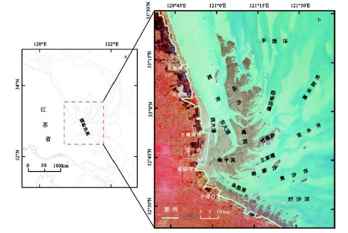
研究区位于江苏中部沿海,120°45′E~121°45′E、32°30′N~33°30′N,是南黄海辐射沙洲的近岸区域,在辐射状交汇潮波控制下发育了大范围的低潮出露潮滩,包括条子泥、高泥、东沙、蒋家沙、竹根沙等(图1),西洋、平涂洋、草米树洋、苦水洋、黄沙洋、烂沙洋等大型潮汐通道通过西大港、东大港、陈家坞槽、王家槽、条鱼港等潮汐水道深入潮滩内部,并在潮滩内形成了大量的潮沟。
研究数据为美国陆地卫星Landsat系列遥感数据。根据研究区成像质量和潮滩出露情形,筛选1979年以来潮滩大范围出露影像数据4期(表1),其中MSS影像1期、TM影像2期、OLI影像1期。MSS影像空间分辨率为78 m、TM/OLI空间分辨率为30 m。对所有影像统一进行配准校正,地图投影UTM51度投影带,坐标系统为WGS-84坐标系,校正误差均小于0.5个像元。
表1 遥感影像列表
Table 1 List of remote sensing images
| 成像日期 | 空间分辨率 | 卫星 | 传感器 |
|---|---|---|---|
| 1979.09.10 | 78 m | Landsat-3 | MSS |
| 1990.04.15 | 30 m | Landsat-5 | TM |
| 2002.11.10 | 30 m | Landsat-5 | TM |
| 2014.12.13 | 30 m | Landsat-8 | OLI |
潮滩脊线是潮流沙脊低潮出露潮滩的滩面分水线,两侧滩面归槽水分别汇入不同的潮汐水道,其位置变化与两侧潮流水道动力密切相关,是区域动力地貌环境的重要表征。低潮出露潮滩滩面潮沟地物特征明显,通过遥感影像图像增强处理,结合潮滩两侧潮流水道动力特点,可目视判别滩面潮沟末梢相对位置,进而提取潮滩脊线。
研究区地貌空间分异显著,受潮汐水道主槽和支槽组合影响,潮滩脊线呈现组合态势,结合潮滩主体演变特征,将潮滩脊线划分为主线和支线2级。采用ArcGIS10.1对提取的潮滩脊线进行矢量化,对不同时期矢量要素进行空间分析,分析潮滩脊线空间组合和时空演变特征。
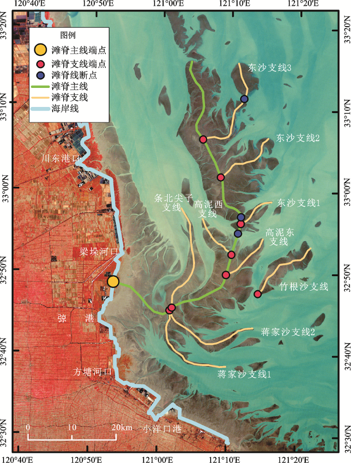
辐射沙洲大范围低潮出露潮滩有条子泥、高泥和东沙,潮滩主体长期存在,是辐射沙洲基本的地貌单元。依据低潮出露潮滩动力地貌形态特征,将辐射沙洲潮滩脊线分为主线和支线2级(图2)。与潮滩主体相对应,辐射沙洲发育了条子泥-高泥-东沙滩脊主线。条子泥与高泥间无显著地貌界限,高泥和东沙间潮汐水道相对稳定存在,滩脊主线在高泥和东沙间发育了滩脊线断点,滩脊主线两侧发育滩脊支线。
图2 滩脊线空间组合示意图(2002年遥感影像)
Fig.2 The spatial combination of the beach ridge lines (remote sensing image in 2002)
条子泥段滩脊主线总体呈东西走向,近岸西段与岸线基本垂直,中段南北两侧分别发育蒋家沙滩脊支线和条北尖子支线,东段通过高泥与东沙段滩脊主线相接;高泥段滩脊主线是条子泥滩脊主线的向北延伸,东侧竹根沙支线呈分离态势(2014年影像显示与高泥并滩),向北延伸方向发育了东西2条滩脊支线;东沙段滩脊主线总体呈南北走向,与岸线基本平行,滩脊东西两侧支线发育不平衡,东侧平行发育多条支线,西侧支线不发育。
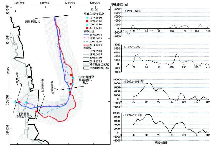
滩脊主线是辐射沙洲大型低潮出露潮滩宏观形态特征的表征,其迁移变化反映了辐射沙洲区域范围动力地貌的演变特征。从图3可以看出,滩脊主线连岸端点和豆腐渣腰门滩脊断点是滩脊主线上的典型特征点。滩脊主线连岸端点是滩脊主线与海岸线的交接位置,受岸滩围垦活动的影响连岸端点持续向海推进。1979~2014年端点总体呈东南方向迁移、迁移距离达14 094 m,其中1979~1990年和1990~2002年2个时段呈相对稳定的东向迁移、迁移距离分别为1 770 m和4 446 m,2002~2014年东南向大幅迁移、迁移距离达8 721 m。豆腐渣腰门滩脊断点位于高泥滩脊主线和东沙滩脊主线之间,是高泥和东沙间的豆腐渣腰门水道演变的体现。1979年和1990年均为单一断点,2002年和2014年发育为2个断点组合存在,断点位置总体呈北向迁移态势,最大迁移距离达9 833 m,其中1979~1990年断点南向迁移1 117 m,1990~2002年由一个断点演化为2个断点、北向迁移距离分别达5 275 m、8 961 m,2002~2014年2个断点持续北向迁移、迁移距离分别为363 m、2 349 m。
在不同时期滩脊线提出的基础上,采用测量断面统计分析法[15]对滩脊线的空间位置变化进行分析(图3)。条子泥-高泥-东沙滩脊主线空间摆动幅度累计平均距离约4 235 m,滩脊主线条子泥段>高泥段>东沙段,最大距离10 135 m、位于条子泥段中部(测量断面68),最小距离200 m、位于东沙段北部(测量断面182)。由于滩脊主线的条子泥段和高泥段相连,将条子泥-高泥段、东沙段分别统计显示,条子泥-高泥段摆动幅度平均距离6 158 m、东沙段2 414 m,且条子泥-高泥段中部>东西两侧、东沙段南部>北部。滩脊主线摆动幅度极小值分布在高泥段与东沙段交界处、东沙段北部,条子泥西段的统计低值目前在围垦区域内部。
对滩脊主线条子泥-高泥段、东沙段在1979~1990年、1990~2002年、2002~2014年3个时段迁移摆动特征统计分析显示,条子泥-高泥段3个时期平均迁移距离分别为-487 m(北向)、1 226 m(南向)、4 537 m(南向),平均速率分别为-46 m/a、98 m/a、375 m/a;东沙段3个时期平均迁移距离分别568 m(东向)、1 050 m(东向)、430 m(东向),平均速率分别为54 m/a、84 m/a、36 m/a。可以看出,3个时段滩脊主线条子泥-高泥段总体迁移摆动呈先北向后南向、且迁移速率呈显著逐步增大趋势,东沙段总体持续东向迁移摆动、迁移速率呈先增大后减小特征。
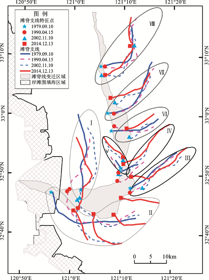
在不同时期滩脊支线提出的基础上,对滩脊支线时空变迁特征进行分析(图4),滩脊支线端点变迁特征统计结果如表2所示。1979~1990年滩脊支线端点变化较为显著的为条北尖子支线、蒋家沙支线,其迁移距离分别4 169 m、4 767 m;1990~2002年滩脊支线端点迁移变化较1979~1990年更为显著,支线端点变化最大的为东沙支线1、东南向迁移6 283 m;2002~2014年蒋家沙支线和竹根沙支线形态显著变化,蒋家沙支线长度萎缩的同时分支增多,竹根沙支线根部与高泥并滩涂;1979~2014年各支线端点迁移变化显著,其中蒋家沙支线变化最为显著,高泥东支线和东沙支线3变化相对较小。不同时期滩脊支线总体特征表现为,滩脊支线演变随相连的滩脊主线不断发展变化,潮滩支线动态空间分异明显,条子泥滩脊线分支形态变化均较高泥和东沙滩脊线分支显著,其中条北尖子支线南向迁移、形态稳定,蒋家沙支线东南向移动、分支增多缩短,竹根沙支线北移、逐步向高泥并滩,高泥东西两支东北向移动、逐步发展延伸,东沙滩脊支线1东向移动、并逐渐萎缩,东沙滩脊支线2和3的东段总体稳定、西段分别表现为北向移动和南向移动,东沙滩脊支线3中部发育有断点、其位置相对稳定。
表2 不同时期滩脊支线端点变迁统计
Table 2 Statistics of the endpoints of the branch ridge lines in different periods
| 滩脊支线名称 | 端点迁移距离(m)、方向 | |||
|---|---|---|---|---|
| 1979~1990年 | 1990~2002年 | 2002~2014年 | 1979~2014年 | |
| 条北尖子支线 | 4 169 ← | 4 500 →↓ | 2 601 ↓ | 5 772 ↓ |
| 蒋家沙支线 | 4 767 → | 4 642 →↓ | 3 080 ←↓ | 9 039 →↓ |
| 6 312 →↓ | 14 724 →↓ | |||
| 12 051 →↓ | 20 636 →↓ | |||
| 13 641 → | 21 730 → | |||
| 竹根沙支线 | 1 430 ←↓ | 4 164 →↑ | 5 240 ←↑ | 3 608 ↑ |
| 高泥东支线 | 3 431 ↓← | 1 849 ↑→ | 4 459 ↑→ | 2 878 ↑→ |
| 高泥西支线 | 1 304 ↓← | 3 969 ↑→ | 866 ↑→ | 3 569 ↑→ |
| 东沙支线1 | 1 338 ↑→ | 6 283 →↓ | 3 306 ↑← | 4 769 → |
| 东沙支线2 | 1 560 →↓ | 2 943 ↑→ | 2 531 ↑← | 4 781 ↑→ |
| 东沙支线3 | 528 ↓→ | 2 907 ↓ | 765 →↑ | 3 119 ↓→ |
图4 不同时期滩脊支线变迁注:Ⅰ. 条北尖子支线;Ⅱ. 蒋家沙支线;Ⅲ. 竹根沙支线;Ⅳ.高泥东支线;Ⅴ.高泥西支线;Ⅵ.东沙支线1;Ⅶ.东沙支线2;Ⅷ.东沙支线3。
Fig.4 Changes of the branch ridge lines in different periods
大范围低潮出露潮滩有条子泥、高泥和东沙是辐射沙洲基本地貌单元。潮滩脊线可分为主线和支线,滩脊主线为条子泥-高泥-东沙潮滩脊线,主线两侧发育滩脊线分支。潮滩脊线空间组合形态总体较为稳定,条子泥滩脊线总体呈东西向,南北两侧分布发育蒋家沙滩脊支线和条北尖子支线,高泥滩脊线连接条子泥和东沙滩脊,东侧和北侧发育有竹根沙支线、高泥东支线、高泥西支线,东沙滩脊线总体呈南北向,其东侧平行发育3条支线。
滩脊主线连岸端点和豆腐渣腰门滩脊断点是条子泥-高泥-东沙滩脊主线上的典型特征点。条子泥滩脊线西侧连岸端点随着围垦工程的实施逐步向海推进,1979~2014年累计东南方向迁移距离达14 094 m;高泥滩脊主线和东沙滩脊主线之间的豆腐渣腰门滩脊断点呈北向迁移态势,1979~2014年累计北向迁移距离达9 833 m。
潮滩脊线演变动态存在显著空间分异,条子泥-高泥段总体迁移摆动呈先北向后南向、且迁移速率呈显著逐步增大趋势,东沙段总体持续东向迁移摆动、迁移速率呈先增大后减小特征。1979~2014年条子泥-高泥-东沙滩脊主线空间摆动幅度平均距离约4 235 m ,条子泥-高泥段6 158 m、东沙段2 414 m,且条子泥-高泥段中部>东西两侧、东沙北部>南部,滩脊主线摆动幅度极小值分布在高泥与东沙交界处和东沙北部。滩脊支线演变随相连的滩脊主线不断发展变化,条子泥滩脊线分支形态和位置变化均较东沙滩脊线分支显著。
潮滩脊线空间组合形态基本稳定,反映了辐射沙洲潮流水道及其之间潮滩总体位置形态相对稳定,区域动力地貌环境处于相对稳定的状态,这与已有研究成果认为辐射沙洲以弶港为中心呈辐射状与宏观稳定岸线格局下辐聚辐散潮流动力相适应的特征较为一致。滩脊主线条子泥段南向迁移显著、东沙段和高泥段总体向东迁移,反映了北侧西侧西洋水道动力持续增强,这也符合已有研究认为辐射沙洲大范围区域水动力主轴逐步向南偏移的认识。滩脊支线位置和形态变化特征详细刻画了辐射沙洲内部的变化特点,反映了辐射沙洲内部动力地貌变化的活跃度和发展方向。潮滩脊线作为辐射沙洲区域典型的地貌特征线,其时空变化深刻反映了区域空间动力地貌演变发展过程,而辐射沙洲规模宏大、潮滩冲淤多变,传统地形地貌调查难度大,遥感地貌特征线可与实测数据相互支撑用于区域动力地貌演变特征的研究。
The authors have declared that no competing interests exist.
| [1] |
|
| [2] |
Sediment transport over an accretional intertidal flat with influences of reclamation, Jiangsu coast, China [J].https://doi.org/10.1016/j.margeo.2011.01.004 URL 摘要
78 Hydrodynamic and sediment transport have responses to reclamations on tidal flat. 78 Suspended sediment fluxes are dominated by the longshore component. 78 Onshore–offshore fluxes provide sufficient sediment supply for tidal flat accretion. 78 Fine-grained sediment transport onshore, together with coarse sediment offshore. 78 Tidal flat equilibrium shape of cross-section cannot maintain under reclamations.
|
| [3] |
Seasonal pattern of Tidal-Flat topography along the Jiangsu middle coast, China, using HJ-1 optical images [J].https://doi.org/10.1007/s13157-013-0445-6 URL 摘要
Seasonal topographical changes in the intertidal zone are of high interest in many parts of the world. Due to existing challenges in mapping this dynamics, little is known about the seasonal pattern o
|
| [4] |
Evolution of sedimentary environments of the middle Jiangsu coast, South Yellow Sea since late MIS 3 [J].https://doi.org/10.1007/s11442-013-1051-5 URL [本文引用: 1] 摘要
An evolutionary model of sedimentary environments since late Marine Isotope Stage 3 (late MIS 3, i.e., ca. 39 cal ka BP) along the middle Jiangsu coast is presented based upon a reinterpretation of core 07SR01, new correlations between adjacent published cores, and shallow seismic profiles recovered in the Xiyang tidal channel and adjacent northern sea areas. Geomorphology, sedimentology, radiocarbon dating and seismic and sequence stratigraphy are combined to confirm that environmental changes since late MIS 3 in the study area were controlled primarily by sea-level fluctuations, sediment discharge of paleo-rivers into the South Yellow Sea (SYS), and minor tectonic subsidence, all of which impacted the progression of regional geomorphic and sedimentary environments (i.e., coastal barrier island, freshwater lacustrine swamp, river floodplain, coastal marsh, tidal sand ridge, and tidal channel). This resulted in the formation of a fifth-order sequence stratigraphy, comprised of the parasequence of the late stage of the last interstadial (Para-Sq2), including the highstand and forced regressive wedge system tracts (HST and FRWST), and the parasequence of the postglacial period (Para-Sq1), including the transgressive and highstand system tracts (TST and HST). The tidal sand ridges likely began to develop during the postglacial transgression as sea-level rise covered the middle Jiangsu coast at ca. 9.0 cal ka BP. These initially submerged tidal sand ridges were constantly migrating until the southward migration of the Yellow River mouth to the northern Jiangsu coast during AD 1128 to 1855. The paleo-Xiyang tidal channel that was determined by the paleo-tidal current field and significantly different from the modern one, was in existence during the Holocene transgressive maxima and lasted until AD 1128. Following the capture of the Huaihe River in AD 1128 by the Yellow River, the paleo-Xiyang tidal channel was infilled with a large amount of river-derived sediments from AD 1128 to 1855, causing the emergence of some of the previously submerged tidal sand ridges. From AD 1855 to the present, the infilled paleo-Xiyang tidal channel has undergone scouring, resulting in its modern form. The modern Xiyang tidal channel continues to widen and deepen, due both to strong tidal current scouring and anthropogenic activities.
|
| [5] |
辐射沙脊群地貌结构遥感解析 [J].https://doi.org/10.3969/j.issn.1672-0504.2014.04.007 URL [本文引用: 1] 摘要
Due to lack of the contemporary hydrographic and bathymetric data,details of the dynamic geomorphology structure are rarely studied.In this paper,based on remote sensing images,morphological skeleton line was introduced to illustrate structure elements of sand ridges.The elements such as the trend of sand ridges,the trend of sandbars,offset direction and angular separation were calculated.The result showed that wing-feather shape of geomorphologic structure was the main characteristic in radial sand ridges.From this study,we will not only deepen the understanding of dynamic geomorphology of radial sand ridges and also obtain the basis for further exploring the geomorphology evolution.
Geomorphologic structure analysis of radial sand ridges .https://doi.org/10.3969/j.issn.1672-0504.2014.04.007 URL [本文引用: 1] 摘要
Due to lack of the contemporary hydrographic and bathymetric data,details of the dynamic geomorphology structure are rarely studied.In this paper,based on remote sensing images,morphological skeleton line was introduced to illustrate structure elements of sand ridges.The elements such as the trend of sand ridges,the trend of sandbars,offset direction and angular separation were calculated.The result showed that wing-feather shape of geomorphologic structure was the main characteristic in radial sand ridges.From this study,we will not only deepen the understanding of dynamic geomorphology of radial sand ridges and also obtain the basis for further exploring the geomorphology evolution.
|
| [6] |
辐射沙脊群地貌遥感制图 [J].https://doi.org/10.6046/gtzyyg.2014.01.21 URL Magsci [本文引用: 1] 摘要
<p>江苏省苏北岸外辐射沙脊群是由潮流沙脊组成的大型砂质堆积体,其海区水动力环境及地质地貌复杂多变,难以开展实地调查。根据遥感图像反映的色调、纹理信息,结合实测地形数据以及历史海图、历史地貌图等,进行了辐射沙脊群地貌遥感制图,并对辐射沙脊群地貌进行了空间特征分析。利用遥感图像绘制辐射沙脊群地貌图,对研究辐射沙脊群的地貌结构及辐射沙脊群空间资源开发利用,都能提供切实可靠的科学依据。</p>
Geomorphologic mapping by remote sensing in radial submarine sand ridges. https://doi.org/10.6046/gtzyyg.2014.01.21 URL Magsci [本文引用: 1] 摘要
<p>江苏省苏北岸外辐射沙脊群是由潮流沙脊组成的大型砂质堆积体,其海区水动力环境及地质地貌复杂多变,难以开展实地调查。根据遥感图像反映的色调、纹理信息,结合实测地形数据以及历史海图、历史地貌图等,进行了辐射沙脊群地貌遥感制图,并对辐射沙脊群地貌进行了空间特征分析。利用遥感图像绘制辐射沙脊群地貌图,对研究辐射沙脊群的地貌结构及辐射沙脊群空间资源开发利用,都能提供切实可靠的科学依据。</p>
|
| [7] |
南黄海辐射沙洲内缘区演变驱动机制及围垦布局研究[D] .The driving mechanism and reclamation spatial layout of the inner part of radial sandbanks in the South Yellow Sea. |
| [8] |
|
| [9] |
辐射沙脊群条子泥动力地貌演变遥感分析 [J].https://doi.org/10.3876/j.issn.1000-1980.2011.02.021 URL 摘要
针对辐射沙脊群汇聚带条子泥冲淤多变的特性,采用遥感与地面测量相结合的方法,重点选用10期低潮位遥感影像和2006-2009年4期地形测量数据,研究了条子泥二分水动力均衡、沙洲稳定性、主要潮水沟演变和近期地形冲淤.研究结果表明:条子泥相对稳定区主要分布于弶港近岸边滩和二分水滩脊;二分水总体稳定、先北后南摆动;近40年来,条子泥总体冲淤剧烈,呈现北冲南淤的新动向.条子泥中心主体稳定,除西部边滩外,外缘边滩相对冲淤活跃,条子泥围垦应充分考虑此特征.采用多时相遥感,将潮滩稳定性和二分水演变作为潮滩动力地貌分析要素,该方法新颖、实用.
Tidal flat evolution analysis using remote sensing on Tiaozini flat of the radial sand ridges. https://doi.org/10.3876/j.issn.1000-1980.2011.02.021 URL 摘要
针对辐射沙脊群汇聚带条子泥冲淤多变的特性,采用遥感与地面测量相结合的方法,重点选用10期低潮位遥感影像和2006-2009年4期地形测量数据,研究了条子泥二分水动力均衡、沙洲稳定性、主要潮水沟演变和近期地形冲淤.研究结果表明:条子泥相对稳定区主要分布于弶港近岸边滩和二分水滩脊;二分水总体稳定、先北后南摆动;近40年来,条子泥总体冲淤剧烈,呈现北冲南淤的新动向.条子泥中心主体稳定,除西部边滩外,外缘边滩相对冲淤活跃,条子泥围垦应充分考虑此特征.采用多时相遥感,将潮滩稳定性和二分水演变作为潮滩动力地貌分析要素,该方法新颖、实用.
|
| [10] |
江苏岸外条子泥二分水滩脊的沉积特征 [J].
Sedimentarry characteristics of the erfenshui tidal ridge of the tiaozini sandbank of Jiangsu province.
|
| [11] |
条子泥二分水滩脊地貌动力与演变特征研究 [J].
Hydrodynamic-morphodynamic characteristics and evolution tendency of the Erfenshui water-dividing beach ridge of the Tiaozini tidal sandbank, Jiangsu coast, China. Hydro-Science and
|
| [12] |
南黄海辐射沙洲趋势性演变的动力机制分析 [J].
南黄海辐射沙洲区水道及其之间的沙洲普遍存在逐渐向南偏移的趋势,对这种趋势性演变机理及驱动力的认识成为辐射沙洲区海岸开发过程中亟待解决的问题。在恢复黄河北归以来苏北黄河三角洲海岸不同发育阶段的岸线位置和水下地形的基础之上,通过所建立的潮波数学模型,研究了在苏北黄河三角洲不同演变阶段南黄海潮波系统的特征及其变化。研究表明,随着岸线后退和水下三角洲的夷平,辐射沙洲地区潮差不断增大;水动力不断加强,而且加强的区域逐渐向南偏移,这种大范围区域性水动力主轴的向南偏移有可能是导致辐射沙洲整体南移的主导因素之一。
Hydrodynamic mechanism of evolvement trends in radial sandbank of South Yellow Sea, China.
南黄海辐射沙洲区水道及其之间的沙洲普遍存在逐渐向南偏移的趋势,对这种趋势性演变机理及驱动力的认识成为辐射沙洲区海岸开发过程中亟待解决的问题。在恢复黄河北归以来苏北黄河三角洲海岸不同发育阶段的岸线位置和水下地形的基础之上,通过所建立的潮波数学模型,研究了在苏北黄河三角洲不同演变阶段南黄海潮波系统的特征及其变化。研究表明,随着岸线后退和水下三角洲的夷平,辐射沙洲地区潮差不断增大;水动力不断加强,而且加强的区域逐渐向南偏移,这种大范围区域性水动力主轴的向南偏移有可能是导致辐射沙洲整体南移的主导因素之一。
|
| [13] |
基于MSS/ETM影像辐射沙脊群沙脊地貌遥感演变分析 [J].Sand ridge geomorphic remote sensing evolution analysis of radial sand ridges based on MSS/ETM [J]. |
| [14] |
辐射沙脊群蒋家沙西段地貌演变特征 [J].Geomorphic evolution characteristics of western segment of Jiangjiasha in radial sand ridge group area. |
| [15] |
The Digital Shoreline Analysis System(DSAS) Version 4. 0- An ArcGIS Extension for Calculating Shoreline Change [R]. |

/
| 〈 |
|
〉 |