隋雪艳 , 吴巍, 汪婧
SUI Xue-yan, WU Wei, WANG Jing
中图分类号: F407.9
文献标识码: A
文章编号: 1000-0690(2015)06-0683-07
通讯作者:
收稿日期: 2013-11-1
修回日期: 2014-06-11
网络出版日期: 2015-06-20
版权声明: 2015 《地理科学》编辑部 本文是开放获取期刊文献,在以下情况下可以自由使用:学术研究、学术交流、科研教学等,但不允许用于商业目的.
基金资助:
作者简介:
作者简介:隋雪艳(1982-),女,山东安丘人,博士研究生,高级工程师,研究方向:土地经济、土地利用规划。E-mail:xueyan322@sina.com
展开
摘要
以南京市江宁区为例,基于2004~2011年住宅用地出让数据,利用空间扩展模型和GWR模型对都市新区住宅地价空间异质性及其驱动因素进行研究。结果表明:① 空间扩展模型与GWR模型分别可解释采样区63%、61%的住宅地价变化,较全局回归模型(47%)有显著提升,更有利于研究土地市场的空间异质性。② 空间扩展模型可有效表征各解释变量及其交互项对住宅地价作用的空间结构总体趋势,其拟合效果相对较优。GWR模型则在局部参数估计方面存在优势,借助GIS可将各变量的地价作用模式可视化,从而比空间扩展模型更能有效刻画住宅地价影响因素的空间非平稳性特征,各因素对地价的平均边际贡献排序为水域> 地铁> 大学园区> CBD> 商业网点> 医院,且商业网点、 医院系数值具有方向差异性。③ 距地铁站点、水域、大学园区以及CBD的距离是研究区住宅地价的关键驱动因素,各自存在特有的地价空间作用模式,可为研究区住宅土地市场细分提供科学依据。
关键词:
Abstract
Based on the spatial properties of the database and the final retained Jiangning District Residential land transfer data from 2004 to 2011, spatial expansion method and geographically weighted regression (GWR) model are applied to simulate the spatial heterogeneity of residential land market in urban district. The influencing factors of residential land price were also tested and analyzed. The results show the following aspects.1)Spatial expansion method and geographically weighted regression (GWR) model can be well applied to simulate spatial heterogeneity of land market in target area. The model could respectively explain 63% of the price changes of residential land and 61% of the price changes of residential land. The interpreting abilities improve significantly than that based on global regression model (47%). Both explanations capacity increased by 16%, 14% and spatial expansion method is slightly better than geographically weighted regression (GWR) model. 2) Spatial expansion method can effectively characterize the spatial structure of the overall trend, which is reflected from the explanatory variables and their interaction term effects on residential land. Geographically weighted regression (GWR) model has advantages in terms of the local parameter estimation. It can make the mode of action of each variable premium visualization by means of GIS. This is a strong rebuttal of the traditional assumptions that hedonic price model has coefficient stability. Overall, the spatial expansion model fits relatively better results. Compared with spatial expansion method, geographically weighted regression (GWR) model can more effectively depict spatial non-stationarity of the influencing factors. In the geographically weighted regression(GWR) model, the order of the average marginal contribution on the land premium from high to low is the distance from water, subway, college and CBD, facility, hospital. Additionally, two variables, the distance from facility and hospital, have the directional difference. 3) The distance from subway, water, university and CBD all have positive effect on marginal residential land price in the entire sample area. They are the key driving factors of residential land price .Each of the affecting patterns has a unique land premium space mode of action. Therefore it can provide scientific basis for segmentation of residential land market in target area. Marginal price effect of waters in residential areas of rapid urbanization is generally greater than industrial areas surrounding. The construction of the subway greatly contributed to construction land expansion of Crisscross and upgrading of residential land price. The construction of University City is also an important strategy for urban development in Urban District, The higher the density of University City, the more significant Its role in promoting residential land price. The marginal price effect of entral business dstrict(CBD) on residential land is progressively decreasing trend from the periphery inward City, but it still has upgrading effect on the surrounding residential land price.
Keywords:
城市土地具有空间异质性,在土地制度转型和空间重构背景下,价格信号在土地的区位配置及空间结构塑造方面发挥出有效性,运用空间数据模型研究城市土地价格影响因素及其空间结构变异,探索变异规律已受到关注并成为土地科学的重要研究课题[1~3]。传统特征价格模型重视城市土地自身特征、区位条件、环境设施等因素对地价的边际贡献作用[4,5]。以此为基础,部分学者引入空间滞后与空间误差模型,一定程度提升了模型的拟合效果与解释能力[6]。然而,上述模型一致认为房地价影响因素具备空间稳定性,各因素的边际价格效应在研究区域内为固定常数,忽视了城市土地空间异质性的存在。已有证据表明[7],无论是总体市场或是细分区域,受物业属性、市场供求、消费者偏好等的作用,房地产市场空间异质性普遍存在,房地价影响因素的边际效应随区位变化而变化,具有空间非平稳性特征。
近年来,国外学者应用空间扩展模型与地理加权回归 (Geographically Weighted Regression, GWR) 模型开展关于房地产市场异质性的研究。Fik等构建二阶空间扩展模型模拟研究区住宅市场影响因素的变化特征,发现扩展模型的解释能力远胜于特征价格模型,有力地证明了住宅市场空间异质性的存在 [8];Yates 和Farber研究发现较之全局回归模型,GWR模型能解释研究区90%的住宅价格变化 [9] ;Bitter等发现上述两类模型均能有效探索该区域房地产市场的空间异质性问题,且GWR模型的拟合效果与预测准确率均高于空间扩展模型 [10] ;Gao等也进行了几种回归模型的实证分析[11]。房地产市场空间异质性的研究也逐渐受到国内部分学者的重视,如吕萍[12]、曾晖[13]、汤庆园 [14] 、董冠鹏[15]等分别借助GWR模型和空间扩展模型对房地产市场进行分析,探究房地价格的空间分布规律及其驱动因素,并对其空间异质性进行模拟与预测。然而,已有研究以住宅市场为主,土地市场为辅,且不同计量模型在刻画房地产价格影响因素空间分异准确性方面的对比研究较为鲜见。另外,当前研究地域主要关注社会经济发达、城市建设密集的中心城市区域,而对城市用地快速增长,土地市场逐渐活跃的都市新区有所忽视。本文以都市新区的南京市江宁区为例,构建空间扩展模型与GWR模型进行对比分析,以期深刻理解都市新区住宅土地市场空间异质性的驱动机理,从方法和实践上充实土地经济学的研究案例,同时可为类似地区土地管理工作提供有益借鉴。
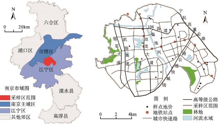
江宁区位于南京市中南部,东、西、南三面环绕主城区,是《南京城市总体规划(2007~2030)》提出的“南北向城镇发展轴”向南延伸的关键枢纽,具有承北接南、内联外引的重要作用。近二十年来,江宁区社会、经济发展取得了巨大进步,是南京市域内区位条件最优,经济发展最快的郊区。2010年,常住人口达114.62万人,实现地区生产总值678.58亿元,其中,一、二、三产增加值比例为4.73:60.07:35.20①【① 南京市江宁区统计局.江宁统计年鉴2010,2011.】速增长的城市新区,江宁较大程度受到南京主城区城市要素的辐射与扩散,土地市场日益活跃,城市基础设施逐渐完善,为研究都市新区住宅地价空间异质性的典型区域。
本文地价样点的采样范围设置为江宁区核心城市发展区域,东至将军山风景区,南以南京绕城高速公路为界,西至宁杭高速公路,北与南京主城相邻接(图1)。该区域土地市场日趋成熟,地价交易样点众多,各类生活设施齐全,已具备了空间异质性研究的基础条件。本文选取2004~2011年江宁区住宅用地出让数据,参照基准地价评估中的基准地价系数修正法经开发水平、出让年限、容积率修正后,以南京市土地交易价格指数[16~18]一同修正至基准日(2010年1月1日),统一地价内涵并建立空间属性数据库,剔除属性残缺与地价特异样点后最终保留住宅地价样点共91个。
图1 2010年采样区及住宅地价样点
Fig.1 Sampling points of residential land price in sampling area in 2010
1) 地价空间扩展模型。空间扩展模型由俄亥俄州立大学地理系的Casetti教授提出[19],利用空间坐标扩展自变量系数以建立驱动因素与地理位置的联系,是一种考虑空间区位并依然采用传统OLS分析框架的多元回归模型,适用于探索房地产市场的空间异质性问题。
本文借鉴已有研究[15,20],设样点K空间坐标为(uk,vk),采用极差标准化公式对各样点的坐标予以标准化,建立三阶多项式空间扩展模型以分析研究区住宅市场价格空间异质性特征,扩展阶段子模型的表述式为:
式中
2) 样点地价地理加权回归(GWR)模型。地理加权回归模型一种探测空间非平稳性的有效方法,允许自变量系数存在空间分异,其实质是利用基于距离加权的局部样本估计出每个样本点各自独立的参数值,在局域立地尺度上的存在空间回归优势[6,9]。 GWR模型的一般形式为:
式中,
式中,
房地产价格由其自身结构特征、经济区位和公共服务设施便利程度构成[21]。地价样点经容积率修正后已基本消除地块特征对住宅地价的影响,结合已有研究[22~25],在此基础上本文主要考虑居住用地的区位条件和公共服务设施便利性两方面因素,初步选取8个解释变量,见表1。设置CBD后连同其他设施要素,包括商业网点、大学园区、医院等,以空间点状要素形式标注在采样区GIS底图上,用以获取住宅地价样点到各类公共服务设施的道路距离。距离变量采用GIS网络分析功能(Network Analyst)进行测算,建立基于路段连接的道路网络模型,并对高等级公路、城市快速路赋予相应权重,求得各地价样点到空间要素点的最短路线,也即最小道路距离。
已有研究认为[26],变量之间相关程度的提高会导致系数估计标准误差的增加,当变量间的相关系数超过0.5时,只允许其中一个变量进入模型可以降低多元共线性对研究结果的影响。应用SPASS 16.0对上述解释变量相关分析发现,各变量间的相关系数普遍偏小,仅中小学 与大学园区、商业网点的皮尔逊相关系数超过0.5,分别为0.564、0.506且通过显著性检验,故将中小学剔除以降低共线性问题对模型解释能力的影响。
表1 解释变量的选取与描述
Table 1 Selection and description of explanation variations
| 解释变量 | 变量描述 | 均值(m) | 最大值(m) | 最小值(m) |
|---|---|---|---|---|
| D(CBD) | 地块至CBD的道路距离 | 5336.25 | 9959.93 | 36.41 |
| D2(Subway) | 地块至地铁站点的道路距离 | 2139.35 | 6089.06 | 64.12 |
| D2(Facility) | 地块至商业网点、银行等商业设施的道路距离 | 1270.03 | 4366.96 | 22.01 |
| D2(College) | 地块至大学园区的道路距离 | 2970.70 | 6736.49 | 153.18 |
| D2(School) | 地块至中小学的道路距离 | 2094.34 | 5814.86 | 95.36 |
| D2(Hospital) | 地块至大型医院的道路距离 | 2814.49 | 7696.28 | 117.19 |
| D2(Water) | 地块至河流、水域的道路距离 | 1443.32 | 4308.05 | 7.51 |
| D2(Green) | 地块至森林、绿地的道路距离 | 1272.04 | 3375.31 | 56.83 |
三阶多项式空间扩展模型回归系数的估算应用OLS逐步回归方法建模,借助Stata12.0编程命令实现,结果见表2,低于5%显著水平的变量未纳入最终模型。扩展模型总体拟合优度R2为0.63,标准估计误差为665.96,可以解释采样区63%的居住用地价格变化。纳入最终模型的变量共计14项,包括3个基础解释变量(临近大学园区、地铁站点、水域的距离),2个坐标项,8个交互项以及常数项。
除交通便利、绿化及其互项统计不显著则被剔除,其余5个解释变量及其与空间坐标的交互项均进入了空间扩展模型。模型结果表明,距大学园区、地铁站点、水域、CBD以及大型医院的距离是影响采样区住宅地价变化的主要因素。由此可判断,地铁站点、水域是采样区住宅地价最为关键的2个驱动因素,地块与其越临近,住宅地价就越高。
在满足显著性条件下,解释变量的交互项越多,说明该变量对居住用地的边际价格效应在空间上的变化模式就越为复杂[27]。由表2可知,地铁、水域、医院分别存在多个交互项,间接地表明这些因素的边际价格效应在空间上并不是固定不变,而是具有非稳定性特征,其对居住用地存在复杂的地价作用模式,这有力地证实了采样区住宅土地市场空间异质性的存在。
表2 住宅地价变化的空间扩展模型估计结果
Table 2 Estimate results for the change of residential land price with spatial expansion model
| 变量 | 标准化B值 | T | sig. | 变量 | 标准化B值 | T | sig. |
|---|---|---|---|---|---|---|---|
| Constant | - | 12.630 | 0.000 | D2(Subwayukvk ) | 1.013 | 2.377 | 0.021 |
| D2(College) | -0.367 | -2.542 | 0.014 | D2(Subway | -0.800 | -2.048 | 0.045 |
| D2(Subway) | -0.975 | -5.856 | 0.000 | D2(Water uk) | -1.754 | -2.361 | 0.022 |
| D2(Water) | -0.914 | -3.336 | 0.002 | D2(Water vk) | 1.192 | 2.756 | 0.008 |
| D2(CBDvk) | -0.253 | -1.988 | 0.050 | D2(Water | 1.352 | 2.461 | 0.017 |
| D2(Hospitalukvk ) | -0.567 | -2.893 | 0.005 | vk | -0.556 | -2.392 | 0.020 |
| D2(Hospital | 0.477 | 3.262 | 0.002 | -0.762 | -2.365 | 0.021 |
地理加权回归模型的参数估计采用相同解释变量,借助GWR 4.0软件实现,输出结果见表3、表4。全局OLS回归即为基于最小二乘法的一般多元线性回归,在进行地理回归建模时,GWR软件同时输出全局回归结果以进行模型拟合效果对比。GWR模型的总体拟合优度R2为0.61,略低于3次空间扩展模型(0.63),但是较全局OLS回归模型提升了0.14,标准估计误差为688.52,可以解释采样区61%的住宅地价变化。表4对住宅地价样点的局部回归系数进行了详细统计,各变量显著性检验表明,除Intercept(截距项)和绿地两变量外,其他变量都分别在1%或5%水平上显著。
各变量边际价格效应的空间非平稳性可从其系数变化范围和四分位差异看出,这进一步量化了居住用地市场的局部空间异质性。表4中系数平均值反应了各变量对采样区住宅地价的平均边际贡献,对通过显著性检验的变量排序为:水域> 地铁> 大学园区> CBD> 商业网点> 医院,平均系数均为负值,表明各类设施对住宅地价均有正向促进作用。
水域、地铁站点对居住用地价格的边际贡献依然位于前列,与前述扩展模型关键驱动因素识别结论相吻合。大学园区对住宅地价的提升效应也在GWR模型中得到证实,其平均系数值为-0.241 9,紧随其后的变量是CBD,平均系数值为-0.080 8。以上4个变量的系数最大、最小值都为负,也即在整个采样区内对居住用地均具有正向边际价格效应,可认为它们是研究区住宅地价变化的关键驱动因素。
表3 全局OLS回归与地理加权回归的拟合结果比较
Table 3 Fitting results comparison between global OLS regression and geographically weighted regression
| 模型类型 | 标准误差估计 | AIC值 | 调整R2 | 残差平方和 |
|---|---|---|---|---|
| GLOBAL OLS Regression | 814.64 | 1174.23 | 0.47 | 47118515.71 |
| GWR Regression | 688.52 | 1166.75 | 0.61 | 33658414.09 |
| GWR Improvement | 126.12 | 7.48 | 0.14 | 13460101.62 |
表4 住宅地价变化的地理加权回归模型估计结果
Table 4 Estimate results for the change of residential land price with geographically weighted regression model
| Variable | 平均值 | 最小值 | 最大值 | 标准差 | 下四分位值 | 中值 | 上四分位值 |
|---|---|---|---|---|---|---|---|
| Intercept | 7441.3968 n/s | 7335.8693 | 7904.3510 | 187.51320 | 7419.8039 | 7507.6871 | 7615.7023 |
| D2(CBD) | -0.0808* | -0.1138 | -0.0641 | 0.0141 | -0.0885 | -0.0785 | -0.0701 |
| D2(College) | -0.2419* | -0.3160 | -0.0475 | 0.0332 | -0.2680 | -0.2544 | -0.2385 |
| D2(Green) | -0.1395 n/s | -0.3551 | 0.0338 | 0.1284 | -0.2530 | -0.1805 | 0.0049 |
| D2(Hospital) | -0.0442** | -0.1919 | 0.1341 | 0.1407 | -0.1960 | -0.0384 | 0.1065 |
| D2(Facility) | -0.0562* | -0.1340 | 0.0821 | 0.0538 | -0.0964 | -0.0752 | -0.0299 |
| D2(Subway) | -0.2961** | -0.3900 | -0.2261 | 0.0341 | -0.3099 | -0.3040 | -0.2751 |
| D2(Water) | -0.2999* | -0.3633 | -0.2596 | 0.0330 | -0.3300 | -0.3086 | -0.2719 |
另外2个变量医院、商业网点的边际效应则存在方向差异性。以医院为例,其系数变化范围为-0.191 9~0.134 1,意味着在某一个空间区位,到大型医院的距离每增加1 000 m,住宅地价将会下降191.9元,而在另一个空间位置,到大型的距离每增加1 000 m,住宅地价则提升134.1元,这进一步验证了扩展模型交互项关于变量复杂地价作用模式的判断。大型商业设施对住宅地价的平均效用偏小,主要是因为采样区为江宁城市发展核心区域,商业网点、银行较为齐全,相对其他变量而言并非关键性因素。
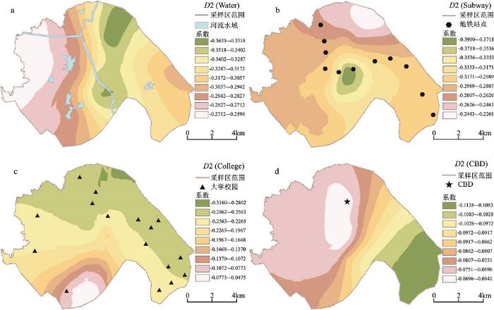
两类模型结果表明,距地铁站点、水域、大学园区以及CBD的距离是研究区住宅地价变化的关键驱动因素,其中,最为核心的2类要素为地铁站点、水域,其对居住用地价格的边际贡献位于前列。利用GIS表面分析功能(Surface Analysis),将GWR模型输出的各地价样点局部参数估计值进行反距离权重插值,见图2。
水域的边际效应主要表现为秦淮河对采样区住宅地价的促进作用,且D2(Water)的系数值东面普遍大于西面。究其原因,秦淮河以西尤其是百家湖周边区域,布置了大量的工业生产性用地,居住用地分布零散,水域对该区域住宅地价的提升作用显然小于东南面快速城市化居住区。地铁站点边际效应的空间分布规律十分有趣,在城市快速扩展区域其对住宅地价的边际贡献较大,南面大学园区次之,主城等已高度发达地区则相对较小。小龙湾、天印大道2个地铁站之间, D2(Subway)的系数值高达0.39,也即每接近地铁站点1 000 m,单位住宅地价将提升390元。该处为江宁区城市发展边缘地带,地铁的建设极大促进了该地带的建设用地扩展与住宅地价提升。
与已有研究区域[11]不同,研究表明大学园区对住宅地价具有显著促进作用,尤其在采样区东南面的江宁大学城,大学园区密度越高,对住宅地价的促进作用就越为显著。该区域交通便利,中国药科大学、中国传媒大学以及南京医科大学等多个大中专院校在此集中建设。CBD边际价格效应从外围向内城呈逐级递减趋势,至CBD周边区域减至最小,但仍对周边地价有提升作用。究其原因,CBD周边以及接近南京主城的北面区域,城市建设密集,经济区位普遍较优,故CBD对该区域住宅地价的影响相对偏小,而在南面快速城市化区域,CBD的辐射作用得到增强,尤其是地铁的开通,有力地延伸了CBD的作用半径。
图2 关键驱动因素对住宅地价边际效用的空间非平稳性
Fig.2 Spatial non-stationarity of residential land price marginal effect of key drivers
空间扩展模型与GWR模型均能够适用于研究区住宅土地市场的空间异质性研究,分别可以解释采样区63%、61%的居住用地价格变化,较之于全局OLS模型(47%),二者的解释能力分别提高16%、14%,扩展模型略优于GWR模型。空间扩展模型可有效表征各解释变量及其交互项对住宅地价作用的空间结构总体趋势,GWR模型则在局部参数估计方面存在优势,借助GIS可将各变量的地价作用模式可视化,有力地辩驳了传统特征价格模型的系数稳定性假设。总体而言,空间扩展模型拟合效果相对较优,但GWR模型对住宅地价影响因素的空间异质性刻画更为准确。
综合两类模型结果,距地铁站点、水域、大学园区以及CBD的距离是研究区住宅地价的关键驱动因素,水域对快速城市化居住区的边际价格效应普遍大于周边的工业区域,地铁的建设极大促进了城乡交错带建设用地扩展与住宅地价提升,而大学城的建设是也是都市新区城市发展的重要策略,大学园区密度越高,其对住宅地价的促进作用就越为显著。这些分析结论都可为研究区住宅土地市场细分提供科学依据。
The authors have declared that no competing interests exist.
| [1] |
Calder. An assessment of coefficient accuracy in linear regression models with spatially varying coefficients [J].https://doi.org/10.1007/s10109-006-0040-y URL [本文引用: 1] 摘要
The realization in the statistical and geographical sciences that a relationship between an explanatory variable and a response variable in a linear regression model is not always constant across a study area has led to the development of regression models that allow for spatially varying coefficients. Two competing models of this type are geographically weighted regression (GWR) and Bayesian regression models with spatially varying coefficient processes (SVCP). In the application of these spatially varying coefficient models, marginal inference on the regression coefficient spatial processes is typically of primary interest. In light of this fact, there is a need to assess the validity of such marginal inferences, since these inferences may be misleading in the presence of explanatory variable collinearity. In this paper, we present the results of a simulation study designed to evaluate the sensitivity of the spatially varying coefficients in the competing models to various levels of collinearity. The simulation study results show that the Bayesian regression model produces more accurate inferences on the regression coefficients than does GWR. In addition, the Bayesian regression model is overall fairly robust in terms of marginal coefficient inference to moderate levels of collinearity, and degrades less substantially than GWR with strong collinearity.
|
| [2] |
城市间土地价格及影响因素的空间差异研究 [J].https://doi.org/10.3969/j.issn.1006-3862.2014.03.021 URL 摘要
不可移动的土地具有空间异质性,研究在分析城市间土地价格空间差异特征的基础上,进行了城市 间土地价格影响因素的理论模型构建和实证分析,进而通过地理加权回归模型分析不同区域城市地价影响因素的差别研究发现,(1)全国尺度看,城市间土地价格 存在空间自相关,城市地价受城市优势和土地需求的正向影响,土地供给的负向影响(2)区域尺度看,城市土地价格受到周边城市土地市场中供求因素和土地价格 的影响,各因素的影响规律存在空间差异性(3)城镇居民人均可支配收入对三大城市群的城市地价的影响均很大,其余各因素则略有不同
|
| [3] |
国内外城市地价时空演变研究进展 [J].https://doi.org/10.3321/j.issn:1007-7588.2008.01.010 URL Magsci [本文引用: 1] 摘要
城市地价时空演变是研究随时间的推进,反映城市土地收益能力的地 价在城市内部空间如何分布的问题,实质是二维地理空间、时间维、地价水平等元素综合构成的四维空间问题.文章在分析地价时空演变内涵的基础上,分别阐述国 内外城市地价空间演变与时序变化的影响因素、研究方法、主要研究成果,并对国内外城市地价时空演变研究的技术方法、成果予以评论,指出现有研究成果对城市 地价的时空演变分析还局限于不同时期地价的静态对比,未将地价空间变迁与时序变化紧密融合起来,没有真正体现城市地价的时空一体化演变过程.最后提出,选 择合适的时空统计分析工具与方法,运用Temporal GIS技术,把影响城市地价时空演变的空间与非空间因素结合起来,探索城市地价在时空上的演变模型,进而监测城市地价时空变化动态,将是城市地价时空演变 研究的主要趋势.
|
| [4] |
Deck L B, Mcconnell K E. On the choice of functional form for hedonic price functions [J].https://doi.org/10.1080/00036849000000002 URL [本文引用: 1] 摘要
This study examines how errors in measuring marginal attribute pric es vary with the form of the hedonic price function. In simulations, consumers with known utility functions bid for houses with given attributes. Various forms of the hedonic function are estimated using equilibrium housing prices. Errors in estimating marginal attribute prices are calculated by comparing each consumer's equilibrium marginal bid vector with the gradient of the hedonic function. When all attributes are observed, linear and quadratic Box-Cox forms produce lowest mean percentage errors; however, when some attributes are unobserved or are replaced by proxies, linear and linear Box-Cox functions perform best. Copyright 1988 by MIT Press.
|
| [5] |
Morgan A. Integrating lidar, GIS and hedonic price modeling to measure amenity values in urban beach residential property markets [J].https://doi.org/10.1016/j.compenvurbsys.2009.10.007 URL Magsci [本文引用: 1] 摘要
Hedonic property price models have been used extensively in the economics literature to measure the value households place on locating properties close to a given resource, such as a beach, river, or lake. This proximity premium consists of two components. First, property owners derive benefit from living close to the resource for access purposes. Second, they also derive benefit from the view of the resource. Critical to the analyses is the identification and measurement of these two components. We augment previous research by providing more accurate and objective measures of access and view for urban beach residential properties. Using GIS, we calculate the distance from each property to the nearest designated public access point. Using lidar data, we calculate the ocean view from each property. These measures are then integrated into a hedonic property price model to disentangle and estimate households鈥 willingness to pay for beach access and view.
|
| [6] |
基于空间计量经济学模型的城市公共服务价值估计 [J].
为估计城市公共服务的价值,并评价城市公共政策,建立了一种空间计量经济学模型。该模型考虑了空间自相关与空间滞后因素,修正了传统特征价格模型(即Hedonic方法)中由于空间相关性造成的影响。利用北京的住宅市场微观交易数据,进行了数据检验,将估计结果与传统的Hedonic方法的结果进行了对比。结果表明:空间相关性显著存在于住宅市场中;不考虑空间作用的模型将会略微高估城市公共服务的价值;该估计结果比用传统的Hedonic方法的结果更可靠。
|
| [7] |
Miyamoto K, Spatial association and heterogeneity issues in land price models [J].https://doi.org/10.1080/00420980120076768 URL [本文引用: 1] 摘要
Urban planners frequently use regression analysis for the empirical estimation of land price models, which are used to investigate the spatial structure of a city or to calculate the implicit price of environmental characteristics. A concern with this kind of analysis is that often spatially associated or heterogeneous data are used, which leads to estimation pitfalls, most notably spatial autocorrelation and model structural instability over space. In this paper, we introduce a modelling methodology that combines a spatial autoregression with a switching regression to incorporate effectively both association and heterogeneity as part of the analysis. In addition, using Sendai City in north-eastern Japan as a case study, we use local statistics of spatial association to assist us in the exploration and definition of heterogeneous regimes. Finally, we show how some measures commonly used to counter spatial effects fail at times, thus highlighting the importance of a spatial modelling methodology such as the one presented here.
|
| [8] |
Modeling spatial variation in housing prices: a variable interaction approach [J].https://doi.org/10.1046/j.1080-8620.2003.00079.x URL [本文引用: 1] 摘要
The absolute location of each real estate parcel in an urban housing market has a unique location-value signature. Accessibility indices, distant gradients and locational dummies cannot fully account for the influence of absolute location on the market price of housing because there are an indeterminable number of externalities (local and nonlocal) influencing a given property at a given location. Furthermore, the degree to which externalities affect real estate values is not only unique at each location but highly variable over space. Hence, absolute location must be viewed as interactive with other determinants of housing value. We present an interactive variables approach and test its ability to explain price variations in an urban residential housing market. The statistical evidence suggests that the value of location, as embodied in the selling price of housing units, may not be separable from other determinants of value. It is recommended that housing valuation models, therefore, be specified to allow site, structural and other independent attributes to interact with absolute location鈥攞, } coordinates鈥攚hen accounting for intraurban variation in the market price of residential housing. This approach is especially useful when estimating the value of housing for geographic areas where very little is known a priori about the neighborhoods or submarkets.
|
| [9] |
A comparison of localized regression models in an hedonic price context [J]. |
| [10] |
Incorporating spatial variation in housing attribute prices: a comparison of geographically weighted regression and the spatial expansion method [J].https://doi.org/10.1007/s10109-006-0028-7 URL Magsci [本文引用: 1] 摘要
Hedonic house price models typically impose a constant price structure on housing characteristics throughout an entire market area. However, there is increasing evidence that the marginal prices of many important attributes vary over space, especially within large markets. In this paper, we compare two approaches to examine spatial heterogeneity in housing attribute prices within the Tucson, Arizona housing market: the spatial expansion method and geographically weighted regression (GWR). Our results provide strong evidence that the marginal price of key housing characteristics varies over space. GWR outperforms the spatial expansion method in terms of explanatory power and predictive accuracy.
|
| [11] |
Chung Chang-Jo F. An empirical evaluation of spatial regression models, https://doi.org/10.1016/j.cageo.2006.02.010 Magsci [本文引用: 2] 摘要
<h2 class="secHeading" id="section_abstract">Abstract</h2><p id="">Conventional statistical methods are often ineffective to evaluate spatial regression models. One reason is that spatial regression models usually have more parameters or smaller sample sizes than a simple model, so their degree of freedom is reduced. Thus, it is often unlikely to evaluate them based on traditional tests. Another reason, which is theoretically associated with statistical methods, is that statistical criteria are crucially dependent on such assumptions as normality, independence, and homogeneity. This may create problems because the assumptions are open for testing. In view of these problems, this paper proposes an alternative empirical evaluation method. To illustrate the idea, a few hedonic regression models for a house and land price data set are evaluated, including a simple, ordinary linear regression model and three spatial models. Their performance as to how well the price of the house and land can be predicted is examined. With a cross-validation technique, the prices at each sample point are predicted with a model estimated with the samples excluding the one being concerned. Then, empirical criteria are established whereby the predicted prices are compared with the real, observed prices. The proposed method provides an objective guidance for the selection of a suitable model specification for a data set. Moreover, the method is seen as an alternative way to test the significance of the spatial relationships being concerned in spatial regression models.</p>
|
| [12] |
基于GWR模型的北京市住宅用地价格影响因素及其空间规律研究 [J].
通过选择住宅地价影响因素并设定量化标准、构建地理加权回归(GWR)模型对1997--2004年北京市住宅用地出让数据进行了统计及空间可视化分析,探索了不同影响因素对北京市住宅用地价格的影响及其空间差异性。发现北京市住宅地价多中心影响效应显现;“生活质量型”较之“生活便利型”基础设施对住宅用地价格的影响更大;地铁与城市快速路对于住宅用地价格的影响具有明显的空间“互补效应”;土地面积对地面单价影响显著。
|
| [13] |
城市住宅价格影响因素的空间非平稳性分析 [J].https://doi.org/10.3969/j.issn.1674-2974.2012.05.018 URL [本文引用: 1] 摘要
应用住宅特征价格法,选取南京 市2011年9月份住宅小区均价作为因变量,选取8个影响住宅价格的因素并量化作为自变量,进行地理加权回归(GWR).与传统的OLS估计相比 较,GWR模型具有更好的拟合优度,同时得出具有显著性的各因素对住宅价格的影响在空间分布上是有差异的,并揭示了这种差异的特点.
|
| [14] |
基于地理加权回归的上海市房价空间分异及其影响因子研究 [J].
利用上海市外环以内2010年12月1014个小区的平均房价数 据,通过构建地理加权回归模型,并与基于全局最小二乘法(OLS)进行比较,揭示上海小区房价的空间分异和不同影响因子的影响。研究发现,每增加或减少一 个单位各影响因子对房价的影响大小依次为:建成时间,到CBD距离,绿化率,到公园距离,距地铁站距离,距超市距离和距学校距离。同时,地理加权回归分解 成局部参数估计优于OLS提供的全局参数估计,它可以深刻的揭示出房价和空间影响因子之间复杂的关系,而且可视化的工具可以用地图的形式更详细的呈现出城 市房价的整体景观,这些都是传统OLS无法比拟的。
|
| [15] |
北京城市住宅土地市场空间异质性模拟与预测 [J].https://doi.org/10.11821/xb201106004 URL Magsci [本文引用: 2] 摘要
土地制度转型和空间重构背景下,价格信号在土地区位配置及空间结构塑造方面发挥出有效性。基于北京市2004-2009年居住用地出让地块微观数据,利用空间扩展模型、地理加权回归模型和特征价格模型对居住用地价格影响因素及其空间异质性进行了有效检验和预测。模型结果表明①居住用地价格影响因素存在着显著的空间异质性,重点小学、轨道交通和公园等设施便利性因素在不同区域对地价的作用强度存在明显差异。②相比于特征价格模型和空间扩展模型,GWR模型能够有效刻画土地市场空间异质性的离散性、突变性和跳跃性,因而其对居住用地影响因素的空间异质性刻画和居住用地价格的预测最为准确。③居住用地价格影响因素的空间异质性表明居住用地子市场存在的可能性,利用GWR模型对地价影响因素的估计可以为土地子市场的划分提供方法借鉴。
|
| [16] |
长春市商业用地基准地价演变过程及驱动因子分析 [J].
基准地价作为中国城市地价体系的重要组成部分,是政府法定的公示地价之一,也是目前中国地价评估的基础。城市基准地价的动态变化过程中,基准地价价格水平的提升和基准地价空间格局的变化是城市经济发展、城市规划建设共同作用的综合结果。论文以长春市商业用地基准地价为例,探索城市基准地价演变的规律。首先计算长春市1995年至2010年商业用地不同级别的地价环比结构的特征值,分析长春市商业用地基准地价的价格动态变化特征;然后利用ESDA分析工具,通过2006年和2010年长春市商业区段路线价的空间格局变化分析来概括讨论长春市商业用地基准地价的空间格局变化;最后结合数学模型分析确定长春市商业用地基准地价演变的驱动因子,最终归纳总结了基准地价演变的规律,即经济发展推动机制、供求机制和规划引导机制共同推进和制约了基准地价的价格和空间格局的演变。
|
| [17] |
|
| [18] |
|
| [19] |
Generating models by the expansion method: applications to geographical research [J].https://doi.org/10.1111/j.1538-4632.1972.tb00458.x URL [本文引用: 1] 摘要
First page of article
|
| [20] |
The temporal and spatial dynamics of income and population growth in Ohio, 1950-1990 [J].https://doi.org/10.1080/00343409412331348226 URL PMID: 12318666 [本文引用: 1] 摘要
"This paper focuses on spatial variation of growth within a state. Using Ohio as a case study, two hypotheses are extracted from the literature. First, the theories of polarization and polarization reversal suggest that in the old industrial core the leading sector role of manufacturing has diminished in old manufacturing poles, and that income growth trends differ substantially between these old poles and new centres of development. Second, the theories of suburbanization and migration reversals suggest that population growth is contingent upon level of urbanization, and that the relationship has changed drastically between the pre-1970s, 1970s, and post-1970s periods." (SUMMARY IN FRE AND GER) excerpt
|
| [21] |
Hedonic prices and implicit markets: product differentiation in pure competition [J].https://doi.org/10.3109/03009734.2012.757682 URL [本文引用: 1] 摘要
No abstract is available for this item.
|
| [22] |
Geographically weighted regression- the analysis of spatially varying relationships [M]. |
| [23] |
基于GWR 模型的南京市住宅地价影响因素及其边际价格作用研究 [J].https://doi.org/10.3969/j.issn.1001-8158.2009.10.004 URL 摘要
研究目的:以南京市为例,探索 城市住宅地价影响因素及其边际作用空间变化性及各因素边际作用大小空间分布状况,为城市土地科学管理提供帮助。研究方法:地理加权回归模型(GWR)。研 究结果:(1)地铁站点、商业网点、水景观、绿地公园对住宅地均价的边际影响能力的空间变化性强,高等学校、医院等其他因素边际作用的空间变化性较弱; (2)容积率住宅地价边际增值能力高于其他因素,各因素在具体不同地块上边际作用能力高低不同。研究结论:GWR模型可以改进传统空间回归方法,可对城市 地价影响因素边际价格作用空间变化性进行良好的估计;住宅土地价格对快速交通、商服条件及自然景观因素较为敏感,反映主城区人们对住宅便捷性及休憩性呈强 偏好;容积率边际增值能力空间变化弱与土地的住宅性用途有关,但容积率始终是边际增值能力最高的因素;GIS良好的输出图像可视化技术能够指导相关部门调 控具体地块的主要规划因素,促进城市土地科学管理。
|
| [24] |
江苏省城市地价影响因素分析与空间结构研究 [J].URL 摘要
本文以江苏省68个地级与县级 市的城市地价为样本,运用因子分析方法对影响地价的诸多变量进行分析,发现城市集聚规模与城市经济发展水平是影响地价的重要因素。对江苏省城市地价进行地 统计分析,发现江苏省城市地价明显表现出区域空间分布规律,表现为江苏省城市地价存在南北、东西两个方向上的梯度变化,运用线性回归方法求得两个方向上的 梯度值;江苏省城市地价整体有一定正相关性,但局域自相关性表现不强;地价以南京、苏州为高地价点,省内地价存在沿沪宁铁路与长江的高地价条带区域。结合 因子分析结果对以上规律做出解释。
|
| [25] |
等 .基于GWR模型的城市住宅地价的时空演变研究——以江苏省为例 [J].
本文通过构建城市住宅地价的GWR模型,对1997、2005和2008年三个时段的江苏省不同区域城市住宅地价影响因素对地价作用的空间变异特征进行了探究,揭示了各个因素因子对地价的影响程度和区域差异,丰富和发展了城市地价影响因素时空变化规律的理论研究。结果表明:①距中心城市距离对地价的贡献为负,且影响区域逐渐增大;②GDP对地价的贡献为正,影响较大区域逐渐向北移动;③城镇化率对地价的贡献逐步减小;④对外交通状况对地价贡献为正,影响逐步增大;⑤从业人口数量对地价的贡献为正,苏南比苏北影响大;⑥苏北房地产投资总额对地价影响高于苏南地区。
|
| [26] |
Urban growth pattern modeling: a case study of Wuhan city, PR China [J].https://doi.org/10.1016/S0169-2046(02)00150-0 URL [本文引用: 1] 摘要
Urban expansion has been a hot topic not only in the management of sustainable development but also in the fields of remote sensing and geographic information science (GIS). After land reform initiated in 1987, Chinese cities are facing a new development wave, which is the mixture of urban expansion and redevelopment. Local urban planners are also facing a huge challenge to require the understanding of complex urban growth process, which involves various actors with different patterns of behavior. Modeling an urban development pattern is the prerequisite to understanding the process. This paper presents a spatial data analysis method to seek and model major determinants of urban growth in the period 1993鈥2000 by a case study of Wuhan City in PR China. The method comprises exploratory data analysis and spatial logistic regression technique. The former is able to visually explore the spatial impacts of each explanatory variable. The latter can provide a systematic confirmatory approach to comparing the variables. The study shows that the major determinants are urban road infrastructure and developed area, and master planning is losing its role in the specific period.
|
| [27] |
Space-varying regression coefficients: a semi-parametric approach applied to real estate markets [J].https://doi.org/10.1111/1540-6229.00801 URL [本文引用: 1] 摘要
This paper presents a method for estimating home values by non-parametrically incorporating the physical location of the properties. Specifically, I allow the parameters of the observed covariates to vary in space. This approach mitigates one of the biggest deficiencies inherent in hedonic pricing models-omitted variables. I demonstrate the advantages of the proposed method using real estate transaction data from Los Angeles County. The estimation finds a substantial spatial variation of the marginal values of the hedonic characteristics and provides an insight into the segmentation of the market. The proposed method is an extension of semi-parametric multi-dimensional k-nearest-neighbor smoothing. It alleviates a fundamental problem known as the curse of dimensionality by incorporating parametric components into a non-parametric estimation. Copyright American Real Estate and Urban Economics Association.
|

/
| 〈 |
|
〉 |