城市群是城镇化发展到高级阶段的空间组织形式。城市群已成为当今世界城镇化发展的趋势[1 ] 。在新的全球化时代背景下,城市群正在成为国家参与全球竞争和国际分工的重要地域单元,其发展深刻地影响着一个国家或地区的国际竞争力,并正在影响着21世纪全球经济的新格局[2 ] 。对城市群空间结构及发展阶段的准确判断,有利于把握城市群发展趋势,明确城市群规划建设实践中的工作重点。
“核心- 边缘”理论是一种揭示区域经济空间结构变化的理论模式[3 ,4 ,5 ,6 ] ,运用这种空间结构模型,在城市群空间格局、城市群区域整合以及促进城市群联动发展方面都有着独到的理论应用价值。“核心- 边缘”理论对于早期发育阶段城市群核心区和外围区的划分提供了理论思路,同时对于诊断早期发育阶段城市群区域不平衡特征有着重要的实践指导意义。根据“核心- 边缘”理论的空间结构模式,城市群可划分为核心区和外围区。核心区是城市群内经济增长领先、最富有持久活力的地区,是能代表城市群形象、承载重要功能、具有较强的集聚效应(人、物、信息流等的集聚)、并对周边地区产生辐射作用的核心地域[7 ] 。外围区城市化水平较低,城镇体系发育不够完善,城市之间的内在联系较弱,区域基础设施仍不够完善[8 ] 。目前对城市群空间结构的划分主要以定性分析方法为主,理论支撑不够,而与城市群空间结构划分相关的定量化研究主要集中在单核和双核都市圈的范围测定方面[9 ,10 ] 。此外,深入理解城市群空间结构特征还需要了解城市群发育程度,所以研究判断城市群发展阶段水平成为与城市群空间结构研究紧密相关的问题。早期代表性的学者弗里德曼认为,城市群的形成发展可分为工业化以前的农业社会、工业化初期、工业化成熟期、工业化后期等4个阶段[11 ] ;法国地理学家戈特曼对于纽约都市区的案例研究,从城市群内城市间相互联系程度出发,把纽约都市区的形成和演化划分为4个阶段:孤立分散阶段、城市间弱联系阶段、大都市带的雏形阶段和大都市带的成熟阶段[12 ] ;而比尔·斯特将城市群空间结构的演化划分为3个阶段,即单中心、多中心和网络化阶段[13 ] ,实际上是将时间、空间属性融合起来研究城市群发展阶段。国内学者对城市群发展阶段的研究主要是以城市群发展水平或发育成熟度来划分的[14 ,15 ,16 ,17 ] ,整合时空二维属性特征的研究明显不足。本文认为城市群发展需要经历雏形发育、快速发育、趋于成熟和稳定发展4个阶段,从核心- 边缘理论视角出发,划分城市群核心区与外围区并研判城市群发展阶段特征对于深化认识城市群空间结构及发育程度具有理论和现实意义。
2014年,国家颁布的《国家新型城镇化规划(2014~2020)》中明确指出:“加快培育成渝、中原、长江中游、哈长等城市群率先发展,使之成为推动国土空间均衡开发、引领区域经济发展的重要增长极”[18 ] 。哈长城市群作为国家新型城镇化战略的重要组成部分,亦为带动东北老工业基地创新发展、协调发展、绿色发展、开放发展、共享发展和全面振兴的重要引擎,目标是将其发展成为面向东北亚开放的城市群,成为中蒙俄经济走廊的核心区域[19 ,20 ] 。然而哈长城市群跨越黑龙江、吉林两省,为东北老工业基地核心地域,城市群发展不成熟,区域发展不平衡。因此,本文基于“核心- 边缘”理论,将哈长城市群划分为核心区和外围区,评判城市群发展阶段水平,探讨针对性发展对策,为哈长城市群发展建设提供科学依据。
1 研究区概况与研究方法
1.1 研究区概况
哈长城市群位于东北地区腹地,南邻辽中南城市群和京津冀城市群,北、东邻俄罗斯远东地区和朝鲜半岛,西邻蒙古国和俄罗斯东西伯利亚地区,由陆路和航空可便捷联通欧洲、北美地区,是中国东北地区对外开放的重要门户。该区域是中国重要的老工业基地和最大的商品粮基地,煤炭、石油、天然气、金属等矿产资源禀赋条件良好,已形成以汽车、装备、能源、石化、农产品加工、医药等为主的现代工业体系,边境贸易、国际物流等服务业快速发展的开放型经济体系初步形成。本文研究的哈长城市群空间范围依据国家批复的《哈长城市群发展规划》划定的范围,包括10个地级市,1个自治州(延边朝鲜族自治州),63个县(含县级市),以及10个地级市的42个市辖区,共计105个县区级研究单元。该城市群国土面积32.31万km2 ,总人口4 711万人,城镇人口2 043万人,2015年GDP为24 836亿元,第一、二、三产业生产总值所占GDP比重分别为13.04%、44.04%和42.92%[21 ,22 ] 。与中国十大城市群的发展主要指标相比,哈长城市群的土地面积较大,但是人口规模和GDP都处于末位,与国内发达的城市群之间的差距明显(表1 )。
本研究数据主要来源于《中国城市统计年鉴2016》[23 ] 、《中国县域统计年鉴2016》[24 ] 、《黑龙江统计年鉴2016》[21 ] 、《吉林统计年鉴2016》[22 ] 和各县(市)区2015年《国民经济和社会发展统计公报》以及各县(市)区政府网站。考虑到公路交通是哈长城市群内经济联系的主要方式,城市间可达性数据选择公路交通网络最短旅行时间数据,作为研究各市县之间可达性及经济联系的基础数据,并参考相关研究,数据采用高德地图自驾选项下的城市间最短旅行时间[25 ] 。查询过程,首先以研究单元当地的汽车站作为出发地和目的地,如果地图中无法搜索到汽车站,则以县(市)政府所在地为出发地或目的地,10个地级市的市辖区均作为县级单元处理,最终获得73×73的最短旅行时间矩阵。部分指标通过间接计算得到。
1.2 研究方法
1.2.1 核心区和外围区划分
本文对核心外围区域划分主要根据城市群内经济发展水平和空间联系的差异性。在确保指标的科学性和可获取性前提下,选取城市化率、人口密度、经济密度、人均GDP、第二产业占GDP比重、第三产业占GDP比重以及公路网密度等7项指标对哈长城市群进行核心区和外围区划分。根据城市群发展规律,核心区为人口和经济社会要素密集、发展水平相对领先的地域,一般情况下应同时具备如下条件:城市化率60%以上,人口密度300人/km2 以上,经济密度1 000万元/km2 以上,人均GDP 50 000元/人以上,第二产业占GDP比重50%以上,第三产业占GDP比重45%以上以及公路网密度7 000 km/104 km2 以上。本文主要参照以上标准,也考虑到哈长城市群发展水平相对落后的现实,将具有4项及以上指标同时满足条件的研究单元判定为具有核心区特征的区域。由于城市群核心区要达到一定的人口和经济规模并能够承担区域中心城市功能,所以哈长城市群核心区判定在上述7项指标判定的基础上,还设定了以下3个原则:一是在空间形态上,核心区为连片的具有核心区特征的空间单元;二是每个核心区空间单元总人口在100万人以上;三是每个核心区空间单元的GDP在2 000亿元以上。基于以上原则和标准,最终划定出哈长城市群核心区,余下则为外围区。
1.2.2 评价指标体系的构建
城市群是一个复杂的系统,目前构建科学合理的指标体系准确评价一个城市群发展阶段仍是一个科学难题。由于城市群所在国家或地区的经济社会发展水平、区域发展环境,以及城市群自身发展状况存在一定的差异,对于城市群发展阶段的划分均有影响。因此,这就要求在建立城市群发展阶段的评判指标体系时要采用定性与定量、理论与实证相结合的方法,以得到客观并具有实际意义的结果。本文采用模糊综合评价法对哈长城市群的发展阶段进行划分。模糊综合评价法是根据模糊数学原理,模拟人脑评判事物的思维过程,将人的主观判断用数量形式加以表达和处理,能够较好地克服指标属性的模糊性,是一种定性和定量评判相结合的方法,也是目前比较成熟的系统评判方法。因此,该方法对于综合评判城市群等复杂系统是比较适用的。
国内外对城市群发展阶段的界定尚没有统一的标准,也没有完善的评价系统。国内已有研究主要集中在城市群处于成熟期以后的特征表述,本文根据模糊综合评价法的原理与城市群系统本身的特征设定评价指标体系。在具体指标选取过程中,依据科学性、可比性和可操作性、定性与定量相结合原则,借鉴已有研究成果[26 ,27 ] ,选取了整体发育水平、经济发展水平、基础设施水平、内部联系水平和外部联系水平5项一级指标,下设18项二级指标(表2 ),各个指标权重的赋值采用AHP方法获得,对城市群发展阶段评价指标体系及其权重赋值如表2 所示。
1.2.3 评判标准的设定
目前,国内外对城市群发展阶段的界定标准不统一。本文借鉴前人研究成果[26 ,27 ,28 ,29 ] ,指标的界定标准主要参考陈群元等人的研究结论[17 ] ,赋值区间部分参考姚士谋[14 ] 和刘荣增对城镇密集区发展阶段判定指标标准[16 ] ,制定了哈长城市群发展阶段的评判指标标准(表3 )。根据哈长城市群的实际情况,本文将“人口密度”和“实际利用外资(近3 a平均)”这二项指标的评判标准作了适当调整。根据城市群发展阶段判断评价赋分方法的相关研究,分值区间90~100分为稳定发展阶段,80~90分为趋于成熟阶段,60~80分为快速发育阶段,低于60分为雏形发育阶段。
2 结果分析
2.1 哈长城市群核心区与外围区
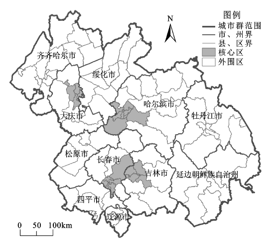
根据“核心- 边缘”理论,按照上述的计算方法和判定原则与标准,考虑到地域单元的规模和功能要求,将哈长城市群划分为核心区和外围区2个空间层次,其空间结构如图1 ,核心区包括黑龙江省哈尔滨市的道里区、南岗区、道外区、香坊区、平房区、松北区、阿城区、双城区,大庆市的萨尔图区、龙凤区、让胡路区、红岗区;吉林省长春市的朝阳区、南关区、宽城区、二道区、绿园区、九台区以及吉林市的昌邑区、龙潭区、船营区、丰满区,共22个单元;其余为外围区,包括核心区以外的83个单元。
图1 哈长城市群核心- 外围区划分
Fig.1 The division of core-peripheral area of Harbin-Changchun Urban Agglomeration
从图1 可见,哈长城市群具有较为明显的核心- 外围特征,目前呈现“3核心- 外围区”空间结构,由长春市和吉林市市辖区为主的区域连片形成的核心区规模最大,由哈尔滨市辖区为主的区域构成的核心区规模次之,由大庆市市辖区为主的区域构成的核心区规模最小。从人口、产业与土地要素配置关系看(表4 ),核心区土地面积仅占哈长城市群6.29%,总人口占25.34%,而外围区土地面积占93.71%,总人口占74.66%,核心区人口密度是外围区的5.06倍;核心区第二产业、第三产业产值均占哈长城市群50%以上;核心区城镇化水平高达73.53%,而外围区城镇化水平仅为33.12%。所以,哈长城市群空间发展不平衡,核心区与外围区之间的经济社会发展差距较大。
2.2 哈长城市群发展阶段判断分析
依据表3 和表4 设定的城市群发展阶段评价指标体系与评判标准,对城市群各指标进行赋值和专家打分,特征分值反映各个指标实际情况分值,换算分值为特征分值经过区间换算法计算的结果,阶段分值为换算分值乘以权重的结果,将所有单项指标阶段分值加总得到合计分值,为判断城市群发展阶段的依据。计算结果如表5 所示,哈长城市群发展阶段评价总体得分为59.42分,在60分以下,处于雏形发育阶段。
依据表5 评价结果,哈长城市群尚处于雏形发育阶段的末期,即将进入快速发育阶段。然而,各项指标换算分值差别较大,表明哈长城市群各个方面发展很不平衡,如人均GDP、人均固定资产投资额、实际利用外资以及年接待旅游人次与本区总人口比值,换算分值均在100分,工业总产值占全省、区比重(90.19分)等,这些指标具备稳定发展阶段的特征。作为典型的老工业基地,哈长城市群的哈尔滨、长春等城市产业发展基础较好,拥有以汽车制造、机械设备、石油化工等为主的产业集群,为吉林省和黑龙江省经济增长重心和人口集聚中心,经济发展水平和工业化水平较高。同时,哈尔滨、长春等旅游业相对发达提升了哈长城市群的对外联系水平。第二产业占GDP比重换算分值为87.02分,达到趋于成熟阶段的水平。
然而,大部分指标的换算分值在60~80分之间,包括城市化率(73.46分),城镇等级规模结构(60.00分),中心城市等级(60.00分),第三产业占GDP比重(72.92分)以及城市间协调机制状况(60.00分)等。从计算结果来看,哈长城市群的城市化率为43.36%,而同期中国城镇化率为56.1%,低于全国平均水平12.74个百分点,城市化率在城市群内部不均衡,部分县市城市化率较低,农业人口比重仍然较大。据统计,2015年哈长城市群三次产业结构比例为13∶44∶43,而同期全国三次产业结构比例分别为8.8∶40.9∶50.2,哈长城市群产业结构相对落后。在城市群空间结构和城市群基础设施方面,城市群等级规模结构、中心城市等级和城市间协调机制状况换算分值均处于成长初期阶段,表明哈长城市群城镇体系发育不足,中心城市的首位度低和集聚水平较低,城市群规模结构和空间结构有待进一步优化。
部分指标的换算分值尚处于雏形发育阶段,得分较低,如人口密度(17.49分),城市间可达性(26.78分),公路网密度(20.22分),城市群信息化程度、城市间功能互补程度和城市间联系密切程度得分均为40分,出口占社会消费品零售额比重(28.92分)等。哈长城市群的人口密度特征分值为145.74人/km2 ,换算分值为17.49分,而2015年长三角城市群的人口密度特征分值为709.92人/km2 。城市群信息化程度、城市间功能互补程度和城市间联系密切程度换算分值均为40分,处在雏形发育的中后期阶段,表明城市群内的产业互补性较弱,区域竞争力不强,城市群内产业分工协作关系不协调,需要政府的引导协作,促进城市群的协同发展。出口占社会消费品零售额比重换算分值为28.92分,表明哈长城市群外向型经济发展严重滞后,这些因素影响了城市群发展的活力,制约了城市群内部的产业结构调整和开放创新活动。
3 结论与启示
本文依据“核心- 边缘”理论,将哈长城市群空间结构划分为核心区和外围区,并采用定性和定量相结合的模糊综合评价方法,对哈长城市群的发展阶段进行了判断分析。研究结果表明,哈长城市群空间结构表现为“3核心- 外围区”空间结构特征,核心区包括22个单元;其余为外围区,包括83个单元。哈长城市群处在雏形发育的末期阶段,城镇体系发育不成熟,核心区以集聚为主,辐射作用不强,外围区产业结构呈现趋同化特征,城市间可达性和信息化水平较低,基础设施不够发达,外向型经济发展活力不足,城市群内区域发展不平衡。哈尔滨和长春作为区域的两个中心城市,城市空间扩张明显,影响范围不断扩大,导致要素流动以向两大城市集聚为主,周边其他城市间的联系相对较弱,城市群整体动力不强。
根据哈长城市群“3核心- 外围区”空间结构及其发展阶段的判断,核心区需要继续强化哈尔滨和长春作为区域中心城市的地位,加强中心城市建设[30 ] ,外围区应加强与核心区的经济社会联系,提高同中心城市之间的连通性,加强区域合作,促进区域协调发展[31 ] 。在国家新一轮振兴东北老工业基地战略和中蒙俄经济走廊建设背景下,哈长城市群面临新的发展机遇。核心区一是大力发展现代服务业,强化对制造业升级的支撑,实现城市群经济发展转型;二是加快城市群基础设施建设,完善综合交通运输体系,加强交通枢纽和交通通道等基础设施建设,提高区域对外综合运输能力和智能化水平;三是在国家“一带一路”倡议和“中蒙俄经济走廊”建设的引导下,重点加强哈大齐牡、长吉图对外开放陆路大通道建设,打造东北亚物流交通枢纽,提升对外开放服务功能。外围区一是要强化节点城市空间连接、功能传导作用,引导产业转移承接和布局优化。以哈尔滨、大庆、长春、吉林城区为中心,联动安达、尚志、五常、舒兰、蛟河、伊通等县(市),形成城市群联动发展区,推动产业协同、功能联动、基础设施共建共享;二是加快尚志、五常、伊通、永吉、蛟河等周边县(市)发展,承接中心城市功能转移;三是加强主要城市和重点城镇的互联互通,突出区域间、经济发展轴间的连接线建设,重点推进国家高速公路,完善大中城市绕城高速公路,新建改造区域间干线公路,完善农村公路网络。
从空间和时间两个维度综合研究判断城市群空间结构和发展状态,是深入认识城市群发展特征与规律的关键。哈长城市群核心区与外围区的划分,表明核心- 边缘理论对认识城市群内部空间发展不平衡性有理论指导意义,可为城市群规划建设实践提供科学依据。本文构建的城市群发展阶段评判指标体系与评判原则标准对于综合评价哈长城市群发展阶段具有较好的适用性,有助于细化认识城市群发展的不同侧面,但受到数据获取限制,选取的评价指标还不够十分全面,下一步需要研究如何将文化、生态等方面指标纳入到评价指标体系中。城市群的发展是一个动态的复杂系统,外部环境变化和内部结构演变规定了城市群空间结构及其发展阶段判断仅仅是某一特定时期的状态判断。除了需要不断完善评价理论和评价技术方法外,还需要通过历史的纵向比较和与其它区域城市群之间的横向比较分析,增强对特定城市群发展阶段判断的科学性。
The authors have declared that no competing interests exist.
参考文献
文献选项
[1]
刘士林 , 刘新静 . 中国城市群发展报告2016 [M]. 上海 :东方出版中心 , 2016 :3 .
[本文引用: 1]
[Liu Shilin Liu Xinjing. Report on the development of China's urban agglomeration in 2016 . Shanghai : Orient Publishing Center , 2016 :3 .]
[本文引用: 1]
[2]
方创琳 . 科学选择与分级培育适应新常态发展的中国城市群
[J]. 中国科学学院刊 ,2015 ,30 (2 ):127 -136 .
[本文引用: 1]
[Fang Chuanglin Scientific selection and grading cultivation of China’s urban agglomeration adaptive to new normal in China
. Bulletin of Chinese Academy of Sciences ,2015 ,30 (2 ):127 -136 .]
[本文引用: 1]
[3]
Friedmann J Regional development policy: A case study of Venezuela
[J]. Urban Studies , 1966 , 4 (3 ):309 -311 .
[本文引用: 1]
[4]
Krugman P Increasing Returns and Economic Geography
[J]. Nber Working Papers , 1990 , 99 (3 ):483 -499 .
https://doi.org/10.1086/261763
URL
[本文引用: 1]
摘要
This paper develops a simple model that shows how a country can endogenously become differentiated into an industrialized "core" and an agricultural "periphery." In order to realize scale economies while minimizing transport costs, manufacturing firms tend to locate in the region with larger demand, but the location of demand itself depends on the distribution of manufacturing. Emergence of a core-periphery pattern depends on transportation costs, economies of scale, and the share of manufacturing in national income.
[5]
Fujita M Krugman P Venables A. The spatial economy: Cities regions and international trade [M]. Cambridge , MT: MIT Press , 1999 :261 -265 .
[本文引用: 1]
[6]
刘艳军 , 李诚固 , 徐一伟 . 城市产业结构升级与空间结构形态演变研究——以长春市为例
[J]. 人文地理 , 2007 , 22 (4 ):41 -45 .
URL
[本文引用: 1]
摘要
产业结构演变与城市空间拓展的互动是城市实现可持续发展的重要路径。本文从产业结构演进与城市用地结构变化、产业结构更新与城市功能地域调整、产业结构调整与城市空间形态优化等方面分析了城市产业结构升级与城市空间形态演变的互动机制,并以长春市为例,研究了长春市产业结构演变与城市空间形态演变的互动变化过程,提出了二者未来互动变化的趋势。
[Liu Yanjun Li Chenggu Xu Yiwei Research on urban industrial structure upgrading and spatial structure from evolvement——A case study of Changchun
. Human Geography , 2007 ,22 (4 ):41 -45 .]
URL
[本文引用: 1]
摘要
产业结构演变与城市空间拓展的互动是城市实现可持续发展的重要路径。本文从产业结构演进与城市用地结构变化、产业结构更新与城市功能地域调整、产业结构调整与城市空间形态优化等方面分析了城市产业结构升级与城市空间形态演变的互动机制,并以长春市为例,研究了长春市产业结构演变与城市空间形态演变的互动变化过程,提出了二者未来互动变化的趋势。
[7]
褚艳华 . 城市地域经济核心区与腹地特征、功能及协调发展研究——以济南市为例[D]
. 济南: 山东师范大学 , 2003 .
[本文引用: 1]
[Zhu Yanhua The Study on the Basic Features and Functions of Urban Area Economic Core Region and Hiterland, and the Coordinating Development Between them—Sampling of Jinan City
. Jinan: Shandong Normal University ,2003 .]
[本文引用: 1]
[8]
顾朝林 , 丁金宏 . 中国大城市边缘区特性研究
[J]. 地理学报 , 1993 ,48 (4 ):317 -328 .
https://doi.org/10.11821/xb199304003
URL
[本文引用: 1]
摘要
论述城市边缘区研究及其进展,城市边缘区的划分,城市边缘区的功能及其组成要素等。
[Gu Chaolin Ding Jinhong The study of the urban fringes in Chinese Megalopolises
. Acta Geographica Sinica , 1993 ,48 (4 ):317 -328 .]
https://doi.org/10.11821/xb199304003
URL
[本文引用: 1]
摘要
论述城市边缘区研究及其进展,城市边缘区的划分,城市边缘区的功能及其组成要素等。
[9]
姜世国 . 都市区范围界定方法探讨——以杭州市为例
[J]. 地理与地理信息科学 , 2004 , 20 (1 ):67 -72 .
https://doi.org/10.3969/j.issn.1672-0504.2004.01.018
URL
[本文引用: 1]
摘要
当前关于都市区范围的界定,主要基于“功能主义方法”,是一种定性分析。根据断裂点公式、距离衰减效应的“简单计算方法”可以定量分析都市区的地域范围。用定性、定量分析方法划分的杭州都市区空间范围基本吻合。根据杭州市与周边县市的关系以及杭州未来发展的需要,针对近期、远期两个发展阶段,可以得到杭州都市区范围的两个可行性方案。笔者认为划分都市区范围,可以用定量分析来弥补定性分析理论依据不足的缺陷。
[Jiang Shiguo The determination of the regional limits of metropolitan area—A case study of a Hangzhou City. Geography and
Geo-Information Science , 2004 , 20 (1 ):67 -72 .]
https://doi.org/10.3969/j.issn.1672-0504.2004.01.018
URL
[本文引用: 1]
摘要
当前关于都市区范围的界定,主要基于“功能主义方法”,是一种定性分析。根据断裂点公式、距离衰减效应的“简单计算方法”可以定量分析都市区的地域范围。用定性、定量分析方法划分的杭州都市区空间范围基本吻合。根据杭州市与周边县市的关系以及杭州未来发展的需要,针对近期、远期两个发展阶段,可以得到杭州都市区范围的两个可行性方案。笔者认为划分都市区范围,可以用定量分析来弥补定性分析理论依据不足的缺陷。
[10]
聂伟 . 都市圈道路网络优化及其评价理论研究[D]
.北京: 北京交通大学 ,2007 .
[本文引用: 1]
[Nie Wei Theory of road network planning and evaluating in metropolitan area
. Beijing: Beijing Jiaotong University ,2007 .]
[本文引用: 1]
[11]
Friedmann J Alonso W Regional Development And Planning: A Reader
[J]. New Zealand Geographer , 1964 , 23 (2 ):179 -179 .
[本文引用: 1]
[12]
Gottmann J Megalopolis or the Urbanization of the Northeastern Seaboard
[J]. Economic Geography , 2007 , 33 (3 ):189 -200 .
https://doi.org/10.2307/142307
URL
[本文引用: 1]
摘要
【Key Words】:
[13]
熊剑平 , 刘承良 , 袁俊 . 国外城市群经济联系空间研究进展
[J]. 世界地理研究 , 2006 , 15 (1 ):63 -70 .
https://doi.org/10.3969/j.issn.1004-9479.2006.01.011
URL
[本文引用: 1]
摘要
城市群经济联系的复杂性空间规律已经成为城市地理学、区域地理学、经济地理学研究的重点范畴。现代意义的城市群经济联系空间发展研究始于50年代,城市群体化现象大规模出现,城市化进程迅速发展的时期。经过二战前的启蒙发展、二战后-60年代的初步发展、70-80年代的丰富深化、90年代的全面发展阶段,50多年来城市群空间研究领域不断深化、研究队伍不断壮大、研究成果不断涌现、研究范式不断丰富,呈现多视角、多层次、多尺度,理论与实证、定性与定量相结合的研究体系,研究内容上文章着重对国外大都市区、都市带等城市群经济联系的空间组织与结构研究进行总结,并指出当前研究的热点与焦点。
[Xiong Jianping Liu Chengliang Yuan Jun Progress in foreign research on economic linkages of city agglomeration
. World Regional Studies ,2006 ,15 (1 ):63 -70 .]
https://doi.org/10.3969/j.issn.1004-9479.2006.01.011
URL
[本文引用: 1]
摘要
城市群经济联系的复杂性空间规律已经成为城市地理学、区域地理学、经济地理学研究的重点范畴。现代意义的城市群经济联系空间发展研究始于50年代,城市群体化现象大规模出现,城市化进程迅速发展的时期。经过二战前的启蒙发展、二战后-60年代的初步发展、70-80年代的丰富深化、90年代的全面发展阶段,50多年来城市群空间研究领域不断深化、研究队伍不断壮大、研究成果不断涌现、研究范式不断丰富,呈现多视角、多层次、多尺度,理论与实证、定性与定量相结合的研究体系,研究内容上文章着重对国外大都市区、都市带等城市群经济联系的空间组织与结构研究进行总结,并指出当前研究的热点与焦点。
[14]
姚士谋 , 陈振光 , 朱英明 . 中国城市群.第3版 [M]. 合肥 :中国科技大学出版社 , 2006 :37 -43 .
[本文引用: 2]
[Yao Shimou Chen Zhenguang Zhu Yingming. The urban agglomeration of China. Third edition. Hefei : University of Science and Technology of China Press , 2006 :37 -43 .]
[本文引用: 2]
[15]
方创琳 , 宋吉涛 , 张蔷 ,等 . 中国城市群结构体系的组成与空间分异格局
[J]. 地理学报 , 2005 , 60 (5 ):827 -840 .
https://doi.org/10.3321/j.issn:0375-5444.2005.05.014
URL
[本文引用: 1]
摘要
The Structures Systems of Urban Agglomerations (SSUAs) in China are the spatial and synthetic polymers coupled organically by Urban Agglomerations with different development degrees, grades, political relationship, formative reasons and spatial locations through various flows of substance, power, information and knowledge. Based on the synthetic analysis of the SSUAs at home and abroad, it is found out that world SSUAs are in the process of formation, the functions with different grades for Urban Agglomerations are fabricating profoundly now through new international division of labor and region, and at the same time, although Urban Agglomerations are in the incipient phase as a whole, they are the most vigorous strategic strong point and growth pole with the greatest potential in the economic development framework in the future, and they will dominate the economic development orientation in China. The paper identifies three grades according to the calculating results using of model subject to the index of development degree for Urban Agglomerations in China. The first grade group constitutes Urban Agglomerations on the Yangtze River Delta, Pearl River Delta and of capital Metropolitan Coordinating Region. The second grade consists of 11 Urban Agglomerations in Shandong Peninsula, Chengdu and Wuhan metropolitan coordinating regions. The third grade group is composed of 14 Urban Agglomerations in the central Yunnan Province and the north Tianshan Mountains. Further analyses indicate that there are great differences among the 28 Urban Agglomerations, but such differences are reasonable to some degree. They have showed some characteristics of regional heterogeneities including different development phases, non-equilibrium in overall distribution, regularities in regional heterogeneous pattern, distinct disintegration and heterogeneity in inter-conglomeration. Based on the above analyses, the paper suggests that future studies should focus on the theoretical studies of the multi-dimension, regularity and phase subject of the SSUAs in China, enhance studies on the differences in heterogeneity and competitiveness in the formation and development of the SSUAs and reinforce research on their internationalization, globalization and dynamic monitoring.
[Fang Chuanglin Song Jitao et al . The formation, development and spatial heterogeneity patterns for the structures system of urban agglomerations in China
. Acta Geographica Sinica , 2005 , 60 (5 ):827 -840 .]
https://doi.org/10.3321/j.issn:0375-5444.2005.05.014
URL
[本文引用: 1]
摘要
The Structures Systems of Urban Agglomerations (SSUAs) in China are the spatial and synthetic polymers coupled organically by Urban Agglomerations with different development degrees, grades, political relationship, formative reasons and spatial locations through various flows of substance, power, information and knowledge. Based on the synthetic analysis of the SSUAs at home and abroad, it is found out that world SSUAs are in the process of formation, the functions with different grades for Urban Agglomerations are fabricating profoundly now through new international division of labor and region, and at the same time, although Urban Agglomerations are in the incipient phase as a whole, they are the most vigorous strategic strong point and growth pole with the greatest potential in the economic development framework in the future, and they will dominate the economic development orientation in China. The paper identifies three grades according to the calculating results using of model subject to the index of development degree for Urban Agglomerations in China. The first grade group constitutes Urban Agglomerations on the Yangtze River Delta, Pearl River Delta and of capital Metropolitan Coordinating Region. The second grade consists of 11 Urban Agglomerations in Shandong Peninsula, Chengdu and Wuhan metropolitan coordinating regions. The third grade group is composed of 14 Urban Agglomerations in the central Yunnan Province and the north Tianshan Mountains. Further analyses indicate that there are great differences among the 28 Urban Agglomerations, but such differences are reasonable to some degree. They have showed some characteristics of regional heterogeneities including different development phases, non-equilibrium in overall distribution, regularities in regional heterogeneous pattern, distinct disintegration and heterogeneity in inter-conglomeration. Based on the above analyses, the paper suggests that future studies should focus on the theoretical studies of the multi-dimension, regularity and phase subject of the SSUAs in China, enhance studies on the differences in heterogeneity and competitiveness in the formation and development of the SSUAs and reinforce research on their internationalization, globalization and dynamic monitoring.
[16]
刘荣增 . 我国城镇密集区发展演化阶段的划分与判定
[J]. 城市规划 , 2003 , 27 (9 ):78 -81 .
[本文引用: 2]
[Liu Rongzeng Classification of the evolution stages of the towns concentrated area in China
. City Planning Review , 2003 , 27 (9 ):78 -81 .]
[本文引用: 2]
[17]
陈群元 , 宋玉祥 , 喻定权 . 城市群发展阶段的划分与评判——以长株潭和泛长株潭城市群为例
[J]. 长江流域资源与环境 ,2009 ,18 (4 ):301 -306 .
Magsci
[本文引用: 2]
摘要
<p>城市群的发展阶段是研究城市群或城市群规划建设中首先需要搞清楚的问题。鉴于目前对城市群发展阶段的划分没有统一标准,综合国内外对城市群发展演化阶段的划分方法,借鉴生命成长规律,把城市群发展划分为雏形发育阶段、快速发育阶段、趋于成熟阶段和成熟发展阶段,并对城市群各发展阶段的特征进行了概述。结合城市群各发展阶段的特征,构建了定性指标与定量指标相结合的城市群发展阶段评判指标体系,并制定了指标评判的界定标准。最后,运用模糊综合评判法和层次分析法,对长株潭城市群与泛长株潭城市群的发展阶段进行了实证评判。评判结果表明,长株潭城市群已处于快速发育阶段,但仍处于快速发育阶段的中前期;泛长株潭城市群仍处于雏形发育阶段,但已处于雏形发育阶段的中期。</p>
[Chen Qunyuan Song Yuxiang Yu Dingquan On dividing and evaluating the development stages of urban agglomerations—Chang-Zhu-Tan and Pan Chang-Zhu-Tan Agglomerations as cases
. Resources and Environment in the Yangtze Basin , 2009 ,18 (4 ):301 -306 .]
Magsci
[本文引用: 2]
摘要
<p>城市群的发展阶段是研究城市群或城市群规划建设中首先需要搞清楚的问题。鉴于目前对城市群发展阶段的划分没有统一标准,综合国内外对城市群发展演化阶段的划分方法,借鉴生命成长规律,把城市群发展划分为雏形发育阶段、快速发育阶段、趋于成熟阶段和成熟发展阶段,并对城市群各发展阶段的特征进行了概述。结合城市群各发展阶段的特征,构建了定性指标与定量指标相结合的城市群发展阶段评判指标体系,并制定了指标评判的界定标准。最后,运用模糊综合评判法和层次分析法,对长株潭城市群与泛长株潭城市群的发展阶段进行了实证评判。评判结果表明,长株潭城市群已处于快速发育阶段,但仍处于快速发育阶段的中前期;泛长株潭城市群仍处于雏形发育阶段,但已处于雏形发育阶段的中期。</p>
[18]
中共中央 , 国务院 . 国家新型城镇化规划 (2014 -2020)
. 新华社, 2014-03-16.
[本文引用: 1]
[The CPC Central Committee The State Council. National New Urbanization Plan(2014 -2020)
. Xinhua News Agency, 2014-03-16.]
[本文引用: 1]
[19]
陈金英 , 杨青山 , 刘贺贺 , 等 . 哈长城市群划界与空间培育战略
[J]. 资源开发与市场 , 2016 , 32 (2 ):178 -182 .
https://doi.org/10.3969/j.issn.1005-8141.2016.02.011
URL
[本文引用: 1]
摘要
基于城市综合承载力评价方法、城市综合质量评价方法、城市相互作用的引力模型等定量测度方法和模型,把握国家战略意图,遵循空间范围划定原则,确定哈长城市群的空间范围,主要包括黑龙江省的哈尔滨、齐齐哈尔、大庆、绥化、牡丹江,吉林省的长春、吉林、四平、松原、辽源、延边朝鲜族自治州在内的11个地级市州,并对空间范围划定结果进行评价与论证,提出打造"二核、三群、四轴、一网"的空间结构,实施"内聚外联"的开发开放联动战略,"枢纽—枢纽区域—枢纽网络"的培育战略和适度超前的基础设施建设战略。
[Chen Jinying Yang Qingshan et al . Space demarcation and spatial cultivating strategy of harbin-changchun urban agglomeration
. Resource Development & Market , 2016 , 32 (2 ):178 -182 .]
https://doi.org/10.3969/j.issn.1005-8141.2016.02.011
URL
[本文引用: 1]
摘要
基于城市综合承载力评价方法、城市综合质量评价方法、城市相互作用的引力模型等定量测度方法和模型,把握国家战略意图,遵循空间范围划定原则,确定哈长城市群的空间范围,主要包括黑龙江省的哈尔滨、齐齐哈尔、大庆、绥化、牡丹江,吉林省的长春、吉林、四平、松原、辽源、延边朝鲜族自治州在内的11个地级市州,并对空间范围划定结果进行评价与论证,提出打造"二核、三群、四轴、一网"的空间结构,实施"内聚外联"的开发开放联动战略,"枢纽—枢纽区域—枢纽网络"的培育战略和适度超前的基础设施建设战略。
[20]
王士君 , 宋飏 , 冯章献 ,等 . 东北地区城市群组的格局、过程及城市流强度
[J].地理科学 , 2011 (3 ):287 -294 .
URL
[本文引用: 1]
摘要
The urban agglomerations in Northeast China group grew up in the special historical period, under a special economic background, and its unique structure and function has been the regional labor division of the old industrial bases in Northeast China, even controled the economy development in Northeast China. According to the connotation of urban agglomeration, cities group and urban agglomeration group, this paper pointed out there currently exist objectively three large urban agglomerations, namely, urban agglomerations of Central Southern Liaoning, Central Jilin and Harbin-Daqing-Qiqihar in Northeast China. According to the formation, development process and the present situation, Central Southern Liaoning has already developed into a mature urban agglomeration, while Central Jilin and Harbin-Daqing-Qiqihar are still in intermediate stage of urban group development. Thus it has been formed a spatial structure with'an agglomeration and two groupsn Northeast China. By the analysis on the urban extroversion meritorious energy and urban flows intensity in three large urban agglomerations in Northeast China, it was found that there is not any city location quotient for the main extrovert service of the urban agglomeration being greater than 1. And their development levels were lower than that of domestic advanced urban agglomeration. The future development should focus on urban agglomeration organization structure, network development pattern, function division and complementary, development relationship coordination, etc., and further control and optimization are needed. Central Southern Liaoning should strengthen the benefit mechanism and efficiency mechanism when the heavy industry and equipment manufacturing continuously develop; Central Jilin should consolidate industrial relation, sticking to the development of automobile industry and emerging industries; Harbin-Daqing-Qiqihar should lay emphasis on resources-substitute industry and emerging industries.
[Wang Shijun Song Yang Feng Zhangxian et al
.Pattern and progress of large urban agglomerations and urban flows intensity in Northeast China. Science Geographic Sinica , 2011 (3 ):287 -294 .]
URL
[本文引用: 1]
摘要
The urban agglomerations in Northeast China group grew up in the special historical period, under a special economic background, and its unique structure and function has been the regional labor division of the old industrial bases in Northeast China, even controled the economy development in Northeast China. According to the connotation of urban agglomeration, cities group and urban agglomeration group, this paper pointed out there currently exist objectively three large urban agglomerations, namely, urban agglomerations of Central Southern Liaoning, Central Jilin and Harbin-Daqing-Qiqihar in Northeast China. According to the formation, development process and the present situation, Central Southern Liaoning has already developed into a mature urban agglomeration, while Central Jilin and Harbin-Daqing-Qiqihar are still in intermediate stage of urban group development. Thus it has been formed a spatial structure with'an agglomeration and two groupsn Northeast China. By the analysis on the urban extroversion meritorious energy and urban flows intensity in three large urban agglomerations in Northeast China, it was found that there is not any city location quotient for the main extrovert service of the urban agglomeration being greater than 1. And their development levels were lower than that of domestic advanced urban agglomeration. The future development should focus on urban agglomeration organization structure, network development pattern, function division and complementary, development relationship coordination, etc., and further control and optimization are needed. Central Southern Liaoning should strengthen the benefit mechanism and efficiency mechanism when the heavy industry and equipment manufacturing continuously develop; Central Jilin should consolidate industrial relation, sticking to the development of automobile industry and emerging industries; Harbin-Daqing-Qiqihar should lay emphasis on resources-substitute industry and emerging industries.
[21]
黑龙江统计局 . 黑龙江统计年鉴2016 [M]. 北京 :中国统计出版社 ,2016 .
[本文引用: 2]
[Heilongjiang Statistical Bureau. Heilongjiang statistical yearbook. Beijing : China Statistics Press , 2016 .]
[本文引用: 2]
[22]
吉林省统计局 . 吉林统计年鉴2016 [M]. 北京 :中国统计出版社 ,2016 .
[本文引用: 2]
[Jilin Statistical Bureau. Jilin statistical yearbook. Beijing : China Statistics Press , 2016 .]
[本文引用: 2]
[23]
国家统计局城市社会经济调查司 . 中国城市统计年鉴2016 [M]. 北京 :中国统计出版社 , 2016 .
[本文引用: 1]
[National Bureau of Statistics of China . China city statistical yearbook. Beijing : China Statistics Press , 2016 .]
[本文引用: 1]
[24]
国家统计局农村社会经济调查司 . 中国县域统计年鉴2016 [M]. 北京 :中国统计出版社 , 2016 .
[本文引用: 1]
[National Bureau of Statistics of China . China county statistical yearbook. Beijing : China Statistics Press , 2016 .]
[本文引用: 1]
[25]
史琴琴 , 康江江 , 鲁丰先 ,等 . 山西省县域可达性及城市经济联系格局
[J]. 地理科学进展 , 2016 , 35 (11 ):1340 -1351 .
[本文引用: 1]
[Shi Qinqin Kang Jiangjiang et al . Accessibility and urban economic linkages of counties in Shanxi Province
. Progress in Geography ,2016 , 35 (11 ):1340 -1351 .]
[本文引用: 1]
[26]
雷朝阳 , 陈永秀 . 环鄱阳湖城市群发展阶段的判定分析
[J]. 城市发展研究 , 2009 , 16 (11 ):39 -42 .
https://doi.org/10.3969/j.issn.1006-3862.2009.11.007
URL
[本文引用: 2]
摘要
城市群发展阶段的判定是研究和建设规划城市群的前提。借鉴国内外关于城市群发展阶段的划分和判定标准,对环鄱阳湖城市群的发展阶段进行了实证评判。结果表明,环鄱阳湖城市群已经处于快速发育阶段,但仍处于快速发育阶段的初期阶段,整体发育水平较低。
[Lei Chaoyang Chen Yongxiu On dividing and evaluating the development stages of urban agglomeration around the Poyang Lake
. Urban Studies ,2009 ,16 (11 ):39 -42 .]
https://doi.org/10.3969/j.issn.1006-3862.2009.11.007
URL
[本文引用: 2]
摘要
城市群发展阶段的判定是研究和建设规划城市群的前提。借鉴国内外关于城市群发展阶段的划分和判定标准,对环鄱阳湖城市群的发展阶段进行了实证评判。结果表明,环鄱阳湖城市群已经处于快速发育阶段,但仍处于快速发育阶段的初期阶段,整体发育水平较低。
[27]
朱邦耀 , 宋玉祥 , 李汝资 . 吉林省中部城市群发展阶段评价与分析
[J]. 国土资源科技管理 , 2017 , 34 (1 ):1 -8 .
https://doi.org/10.3969/j.issn.1009-4210.2017.01.001
URL
[本文引用: 2]
摘要
城市群是在工业化、城镇化进程中出现的区域空间形态的高级现象,城市群发展阶段的分析是城市群建设中需要认清的首要问题。分析了城市群发展生命周期和城市群发展的空间结构演变过程,对城市群的发展过程进行了四阶段划分,并以吉林省中部城市群为例,采用模糊综合评价方法对吉林省中部城市群的发展阶段进行了计算与分析。结果表明:吉林省中部城市群处于成长阶段的中期,城市群内城市化发展总体水平较高,但是基础设施水平、城镇体系结构、城市群内部联系水平与外部联系水平尚处于城市群发展阶段中的萌芽期与成长期,需要通过市场与政府的共同作用,来推进城市群的发展和演变,为吉林省内产业与人口的集聚提供支撑载体。
[Zhu Bangyao Song Yuxiang Li Ruzi Evaluation and analysis on urban agglomeration development stage in central Jilin Province
. Scientific and Technological Management of Land and Resources , 2017 , 34 (1 ):1 -8 .]
https://doi.org/10.3969/j.issn.1009-4210.2017.01.001
URL
[本文引用: 2]
摘要
城市群是在工业化、城镇化进程中出现的区域空间形态的高级现象,城市群发展阶段的分析是城市群建设中需要认清的首要问题。分析了城市群发展生命周期和城市群发展的空间结构演变过程,对城市群的发展过程进行了四阶段划分,并以吉林省中部城市群为例,采用模糊综合评价方法对吉林省中部城市群的发展阶段进行了计算与分析。结果表明:吉林省中部城市群处于成长阶段的中期,城市群内城市化发展总体水平较高,但是基础设施水平、城镇体系结构、城市群内部联系水平与外部联系水平尚处于城市群发展阶段中的萌芽期与成长期,需要通过市场与政府的共同作用,来推进城市群的发展和演变,为吉林省内产业与人口的集聚提供支撑载体。
[28]
Zhou Yixing Definition of urban place and statistical standards of urban population in China: Problem and solution
[J]. Asian Geography ,1988 ,7 (1 ):12 -18 .
URL
[本文引用: 1]
[29]
周一星 . 城市地理学 [M].北京 :商务印书馆 ,2003 .
[本文引用: 1]
[Zhou Yixing. Urban geography. Beijing : The Commercial Press ,2003 .]
[本文引用: 1]
[30]
张平宇 . 东北区域发展报告.2008 [M]. 北京 :科学出版社 , 2008 .
[本文引用: 1]
[Zhang Pingyu. Northeast regional development report in 2008. Beijing : Science Press , 2008 .]
[本文引用: 1]
[31]
杨青山 , 李红英 , 梅林 . 改革开放以来东北区城市化与产业结构变动关系研究
[J]. 地理科学 , 2004 , 24 (3 ):314 -319 .
https://doi.org/10.3969/j.issn.1000-0690.2004.03.010
URL
[本文引用: 1]
摘要
This article summarizes the characteristics of urbanization development and the changes of industrial structure in Northeast China, analyzes the relation of urbanization and the changes of industrial structure in Northeast China by applying the mutually prompt law of urbanization and industrialize, the law of the changes of industrial structure and the law of urbanization development, and discusses the reasons of forming this relation. Finally, this article puts forward harmonious strategy on the relation of urbanization and the changes of industrial structure in Northeast China. that is, promoting harmonious development of urbanization and industrial structure by optimining industrial structure, building the reasonable urban system and improving the level of infroastructure.
[Yang Qingshan Li Hongying Mei Lin Relation of urbanization and the changes of industrial structure in Northeast China
. Science Geographic Sinica , 2004 , 24 (3 ):314 -319 .]
https://doi.org/10.3969/j.issn.1000-0690.2004.03.010
URL
[本文引用: 1]
摘要
This article summarizes the characteristics of urbanization development and the changes of industrial structure in Northeast China, analyzes the relation of urbanization and the changes of industrial structure in Northeast China by applying the mutually prompt law of urbanization and industrialize, the law of the changes of industrial structure and the law of urbanization development, and discusses the reasons of forming this relation. Finally, this article puts forward harmonious strategy on the relation of urbanization and the changes of industrial structure in Northeast China. that is, promoting harmonious development of urbanization and industrial structure by optimining industrial structure, building the reasonable urban system and improving the level of infroastructure.
1
2016
... 城市群是城镇化发展到高级阶段的空间组织形式.城市群已成为当今世界城镇化发展的趋势[1 ] .在新的全球化时代背景下,城市群正在成为国家参与全球竞争和国际分工的重要地域单元,其发展深刻地影响着一个国家或地区的国际竞争力,并正在影响着21世纪全球经济的新格局[2 ] .对城市群空间结构及发展阶段的准确判断,有利于把握城市群发展趋势,明确城市群规划建设实践中的工作重点. ...
1
2016
... 城市群是城镇化发展到高级阶段的空间组织形式.城市群已成为当今世界城镇化发展的趋势[1 ] .在新的全球化时代背景下,城市群正在成为国家参与全球竞争和国际分工的重要地域单元,其发展深刻地影响着一个国家或地区的国际竞争力,并正在影响着21世纪全球经济的新格局[2 ] .对城市群空间结构及发展阶段的准确判断,有利于把握城市群发展趋势,明确城市群规划建设实践中的工作重点. ...
科学选择与分级培育适应新常态发展的中国城市群
1
2015
... 城市群是城镇化发展到高级阶段的空间组织形式.城市群已成为当今世界城镇化发展的趋势[1 ] .在新的全球化时代背景下,城市群正在成为国家参与全球竞争和国际分工的重要地域单元,其发展深刻地影响着一个国家或地区的国际竞争力,并正在影响着21世纪全球经济的新格局[2 ] .对城市群空间结构及发展阶段的准确判断,有利于把握城市群发展趋势,明确城市群规划建设实践中的工作重点. ...
科学选择与分级培育适应新常态发展的中国城市群
1
2015
... 城市群是城镇化发展到高级阶段的空间组织形式.城市群已成为当今世界城镇化发展的趋势[1 ] .在新的全球化时代背景下,城市群正在成为国家参与全球竞争和国际分工的重要地域单元,其发展深刻地影响着一个国家或地区的国际竞争力,并正在影响着21世纪全球经济的新格局[2 ] .对城市群空间结构及发展阶段的准确判断,有利于把握城市群发展趋势,明确城市群规划建设实践中的工作重点. ...
Regional development policy: A case study of Venezuela
1
1966
... “核心- 边缘”理论是一种揭示区域经济空间结构变化的理论模式[3 ,4 ,5 ,6 ] ,运用这种空间结构模型,在城市群空间格局、城市群区域整合以及促进城市群联动发展方面都有着独到的理论应用价值.“核心- 边缘”理论对于早期发育阶段城市群核心区和外围区的划分提供了理论思路,同时对于诊断早期发育阶段城市群区域不平衡特征有着重要的实践指导意义.根据“核心- 边缘”理论的空间结构模式,城市群可划分为核心区和外围区.核心区是城市群内经济增长领先、最富有持久活力的地区,是能代表城市群形象、承载重要功能、具有较强的集聚效应(人、物、信息流等的集聚)、并对周边地区产生辐射作用的核心地域[7 ] .外围区城市化水平较低,城镇体系发育不够完善,城市之间的内在联系较弱,区域基础设施仍不够完善[8 ] .目前对城市群空间结构的划分主要以定性分析方法为主,理论支撑不够,而与城市群空间结构划分相关的定量化研究主要集中在单核和双核都市圈的范围测定方面[9 ,10 ] .此外,深入理解城市群空间结构特征还需要了解城市群发育程度,所以研究判断城市群发展阶段水平成为与城市群空间结构研究紧密相关的问题.早期代表性的学者弗里德曼认为,城市群的形成发展可分为工业化以前的农业社会、工业化初期、工业化成熟期、工业化后期等4个阶段[11 ] ;法国地理学家戈特曼对于纽约都市区的案例研究,从城市群内城市间相互联系程度出发,把纽约都市区的形成和演化划分为4个阶段:孤立分散阶段、城市间弱联系阶段、大都市带的雏形阶段和大都市带的成熟阶段[12 ] ;而比尔·斯特将城市群空间结构的演化划分为3个阶段,即单中心、多中心和网络化阶段[13 ] ,实际上是将时间、空间属性融合起来研究城市群发展阶段.国内学者对城市群发展阶段的研究主要是以城市群发展水平或发育成熟度来划分的[14 ,15 ,16 ,17 ] ,整合时空二维属性特征的研究明显不足.本文认为城市群发展需要经历雏形发育、快速发育、趋于成熟和稳定发展4个阶段,从核心- 边缘理论视角出发,划分城市群核心区与外围区并研判城市群发展阶段特征对于深化认识城市群空间结构及发育程度具有理论和现实意义. ...
Increasing Returns and Economic Geography
1
1990
... “核心- 边缘”理论是一种揭示区域经济空间结构变化的理论模式[3 ,4 ,5 ,6 ] ,运用这种空间结构模型,在城市群空间格局、城市群区域整合以及促进城市群联动发展方面都有着独到的理论应用价值.“核心- 边缘”理论对于早期发育阶段城市群核心区和外围区的划分提供了理论思路,同时对于诊断早期发育阶段城市群区域不平衡特征有着重要的实践指导意义.根据“核心- 边缘”理论的空间结构模式,城市群可划分为核心区和外围区.核心区是城市群内经济增长领先、最富有持久活力的地区,是能代表城市群形象、承载重要功能、具有较强的集聚效应(人、物、信息流等的集聚)、并对周边地区产生辐射作用的核心地域[7 ] .外围区城市化水平较低,城镇体系发育不够完善,城市之间的内在联系较弱,区域基础设施仍不够完善[8 ] .目前对城市群空间结构的划分主要以定性分析方法为主,理论支撑不够,而与城市群空间结构划分相关的定量化研究主要集中在单核和双核都市圈的范围测定方面[9 ,10 ] .此外,深入理解城市群空间结构特征还需要了解城市群发育程度,所以研究判断城市群发展阶段水平成为与城市群空间结构研究紧密相关的问题.早期代表性的学者弗里德曼认为,城市群的形成发展可分为工业化以前的农业社会、工业化初期、工业化成熟期、工业化后期等4个阶段[11 ] ;法国地理学家戈特曼对于纽约都市区的案例研究,从城市群内城市间相互联系程度出发,把纽约都市区的形成和演化划分为4个阶段:孤立分散阶段、城市间弱联系阶段、大都市带的雏形阶段和大都市带的成熟阶段[12 ] ;而比尔·斯特将城市群空间结构的演化划分为3个阶段,即单中心、多中心和网络化阶段[13 ] ,实际上是将时间、空间属性融合起来研究城市群发展阶段.国内学者对城市群发展阶段的研究主要是以城市群发展水平或发育成熟度来划分的[14 ,15 ,16 ,17 ] ,整合时空二维属性特征的研究明显不足.本文认为城市群发展需要经历雏形发育、快速发育、趋于成熟和稳定发展4个阶段,从核心- 边缘理论视角出发,划分城市群核心区与外围区并研判城市群发展阶段特征对于深化认识城市群空间结构及发育程度具有理论和现实意义. ...
1
1999
... “核心- 边缘”理论是一种揭示区域经济空间结构变化的理论模式[3 ,4 ,5 ,6 ] ,运用这种空间结构模型,在城市群空间格局、城市群区域整合以及促进城市群联动发展方面都有着独到的理论应用价值.“核心- 边缘”理论对于早期发育阶段城市群核心区和外围区的划分提供了理论思路,同时对于诊断早期发育阶段城市群区域不平衡特征有着重要的实践指导意义.根据“核心- 边缘”理论的空间结构模式,城市群可划分为核心区和外围区.核心区是城市群内经济增长领先、最富有持久活力的地区,是能代表城市群形象、承载重要功能、具有较强的集聚效应(人、物、信息流等的集聚)、并对周边地区产生辐射作用的核心地域[7 ] .外围区城市化水平较低,城镇体系发育不够完善,城市之间的内在联系较弱,区域基础设施仍不够完善[8 ] .目前对城市群空间结构的划分主要以定性分析方法为主,理论支撑不够,而与城市群空间结构划分相关的定量化研究主要集中在单核和双核都市圈的范围测定方面[9 ,10 ] .此外,深入理解城市群空间结构特征还需要了解城市群发育程度,所以研究判断城市群发展阶段水平成为与城市群空间结构研究紧密相关的问题.早期代表性的学者弗里德曼认为,城市群的形成发展可分为工业化以前的农业社会、工业化初期、工业化成熟期、工业化后期等4个阶段[11 ] ;法国地理学家戈特曼对于纽约都市区的案例研究,从城市群内城市间相互联系程度出发,把纽约都市区的形成和演化划分为4个阶段:孤立分散阶段、城市间弱联系阶段、大都市带的雏形阶段和大都市带的成熟阶段[12 ] ;而比尔·斯特将城市群空间结构的演化划分为3个阶段,即单中心、多中心和网络化阶段[13 ] ,实际上是将时间、空间属性融合起来研究城市群发展阶段.国内学者对城市群发展阶段的研究主要是以城市群发展水平或发育成熟度来划分的[14 ,15 ,16 ,17 ] ,整合时空二维属性特征的研究明显不足.本文认为城市群发展需要经历雏形发育、快速发育、趋于成熟和稳定发展4个阶段,从核心- 边缘理论视角出发,划分城市群核心区与外围区并研判城市群发展阶段特征对于深化认识城市群空间结构及发育程度具有理论和现实意义. ...
城市产业结构升级与空间结构形态演变研究——以长春市为例
1
2007
... “核心- 边缘”理论是一种揭示区域经济空间结构变化的理论模式[3 ,4 ,5 ,6 ] ,运用这种空间结构模型,在城市群空间格局、城市群区域整合以及促进城市群联动发展方面都有着独到的理论应用价值.“核心- 边缘”理论对于早期发育阶段城市群核心区和外围区的划分提供了理论思路,同时对于诊断早期发育阶段城市群区域不平衡特征有着重要的实践指导意义.根据“核心- 边缘”理论的空间结构模式,城市群可划分为核心区和外围区.核心区是城市群内经济增长领先、最富有持久活力的地区,是能代表城市群形象、承载重要功能、具有较强的集聚效应(人、物、信息流等的集聚)、并对周边地区产生辐射作用的核心地域[7 ] .外围区城市化水平较低,城镇体系发育不够完善,城市之间的内在联系较弱,区域基础设施仍不够完善[8 ] .目前对城市群空间结构的划分主要以定性分析方法为主,理论支撑不够,而与城市群空间结构划分相关的定量化研究主要集中在单核和双核都市圈的范围测定方面[9 ,10 ] .此外,深入理解城市群空间结构特征还需要了解城市群发育程度,所以研究判断城市群发展阶段水平成为与城市群空间结构研究紧密相关的问题.早期代表性的学者弗里德曼认为,城市群的形成发展可分为工业化以前的农业社会、工业化初期、工业化成熟期、工业化后期等4个阶段[11 ] ;法国地理学家戈特曼对于纽约都市区的案例研究,从城市群内城市间相互联系程度出发,把纽约都市区的形成和演化划分为4个阶段:孤立分散阶段、城市间弱联系阶段、大都市带的雏形阶段和大都市带的成熟阶段[12 ] ;而比尔·斯特将城市群空间结构的演化划分为3个阶段,即单中心、多中心和网络化阶段[13 ] ,实际上是将时间、空间属性融合起来研究城市群发展阶段.国内学者对城市群发展阶段的研究主要是以城市群发展水平或发育成熟度来划分的[14 ,15 ,16 ,17 ] ,整合时空二维属性特征的研究明显不足.本文认为城市群发展需要经历雏形发育、快速发育、趋于成熟和稳定发展4个阶段,从核心- 边缘理论视角出发,划分城市群核心区与外围区并研判城市群发展阶段特征对于深化认识城市群空间结构及发育程度具有理论和现实意义. ...
城市地域经济核心区与腹地特征、功能及协调发展研究——以济南市为例[D]
1
2003
... “核心- 边缘”理论是一种揭示区域经济空间结构变化的理论模式[3 ,4 ,5 ,6 ] ,运用这种空间结构模型,在城市群空间格局、城市群区域整合以及促进城市群联动发展方面都有着独到的理论应用价值.“核心- 边缘”理论对于早期发育阶段城市群核心区和外围区的划分提供了理论思路,同时对于诊断早期发育阶段城市群区域不平衡特征有着重要的实践指导意义.根据“核心- 边缘”理论的空间结构模式,城市群可划分为核心区和外围区.核心区是城市群内经济增长领先、最富有持久活力的地区,是能代表城市群形象、承载重要功能、具有较强的集聚效应(人、物、信息流等的集聚)、并对周边地区产生辐射作用的核心地域[7 ] .外围区城市化水平较低,城镇体系发育不够完善,城市之间的内在联系较弱,区域基础设施仍不够完善[8 ] .目前对城市群空间结构的划分主要以定性分析方法为主,理论支撑不够,而与城市群空间结构划分相关的定量化研究主要集中在单核和双核都市圈的范围测定方面[9 ,10 ] .此外,深入理解城市群空间结构特征还需要了解城市群发育程度,所以研究判断城市群发展阶段水平成为与城市群空间结构研究紧密相关的问题.早期代表性的学者弗里德曼认为,城市群的形成发展可分为工业化以前的农业社会、工业化初期、工业化成熟期、工业化后期等4个阶段[11 ] ;法国地理学家戈特曼对于纽约都市区的案例研究,从城市群内城市间相互联系程度出发,把纽约都市区的形成和演化划分为4个阶段:孤立分散阶段、城市间弱联系阶段、大都市带的雏形阶段和大都市带的成熟阶段[12 ] ;而比尔·斯特将城市群空间结构的演化划分为3个阶段,即单中心、多中心和网络化阶段[13 ] ,实际上是将时间、空间属性融合起来研究城市群发展阶段.国内学者对城市群发展阶段的研究主要是以城市群发展水平或发育成熟度来划分的[14 ,15 ,16 ,17 ] ,整合时空二维属性特征的研究明显不足.本文认为城市群发展需要经历雏形发育、快速发育、趋于成熟和稳定发展4个阶段,从核心- 边缘理论视角出发,划分城市群核心区与外围区并研判城市群发展阶段特征对于深化认识城市群空间结构及发育程度具有理论和现实意义. ...
中国大城市边缘区特性研究
1
1993
... “核心- 边缘”理论是一种揭示区域经济空间结构变化的理论模式[3 ,4 ,5 ,6 ] ,运用这种空间结构模型,在城市群空间格局、城市群区域整合以及促进城市群联动发展方面都有着独到的理论应用价值.“核心- 边缘”理论对于早期发育阶段城市群核心区和外围区的划分提供了理论思路,同时对于诊断早期发育阶段城市群区域不平衡特征有着重要的实践指导意义.根据“核心- 边缘”理论的空间结构模式,城市群可划分为核心区和外围区.核心区是城市群内经济增长领先、最富有持久活力的地区,是能代表城市群形象、承载重要功能、具有较强的集聚效应(人、物、信息流等的集聚)、并对周边地区产生辐射作用的核心地域[7 ] .外围区城市化水平较低,城镇体系发育不够完善,城市之间的内在联系较弱,区域基础设施仍不够完善[8 ] .目前对城市群空间结构的划分主要以定性分析方法为主,理论支撑不够,而与城市群空间结构划分相关的定量化研究主要集中在单核和双核都市圈的范围测定方面[9 ,10 ] .此外,深入理解城市群空间结构特征还需要了解城市群发育程度,所以研究判断城市群发展阶段水平成为与城市群空间结构研究紧密相关的问题.早期代表性的学者弗里德曼认为,城市群的形成发展可分为工业化以前的农业社会、工业化初期、工业化成熟期、工业化后期等4个阶段[11 ] ;法国地理学家戈特曼对于纽约都市区的案例研究,从城市群内城市间相互联系程度出发,把纽约都市区的形成和演化划分为4个阶段:孤立分散阶段、城市间弱联系阶段、大都市带的雏形阶段和大都市带的成熟阶段[12 ] ;而比尔·斯特将城市群空间结构的演化划分为3个阶段,即单中心、多中心和网络化阶段[13 ] ,实际上是将时间、空间属性融合起来研究城市群发展阶段.国内学者对城市群发展阶段的研究主要是以城市群发展水平或发育成熟度来划分的[14 ,15 ,16 ,17 ] ,整合时空二维属性特征的研究明显不足.本文认为城市群发展需要经历雏形发育、快速发育、趋于成熟和稳定发展4个阶段,从核心- 边缘理论视角出发,划分城市群核心区与外围区并研判城市群发展阶段特征对于深化认识城市群空间结构及发育程度具有理论和现实意义. ...
都市区范围界定方法探讨——以杭州市为例
1
2004
... “核心- 边缘”理论是一种揭示区域经济空间结构变化的理论模式[3 ,4 ,5 ,6 ] ,运用这种空间结构模型,在城市群空间格局、城市群区域整合以及促进城市群联动发展方面都有着独到的理论应用价值.“核心- 边缘”理论对于早期发育阶段城市群核心区和外围区的划分提供了理论思路,同时对于诊断早期发育阶段城市群区域不平衡特征有着重要的实践指导意义.根据“核心- 边缘”理论的空间结构模式,城市群可划分为核心区和外围区.核心区是城市群内经济增长领先、最富有持久活力的地区,是能代表城市群形象、承载重要功能、具有较强的集聚效应(人、物、信息流等的集聚)、并对周边地区产生辐射作用的核心地域[7 ] .外围区城市化水平较低,城镇体系发育不够完善,城市之间的内在联系较弱,区域基础设施仍不够完善[8 ] .目前对城市群空间结构的划分主要以定性分析方法为主,理论支撑不够,而与城市群空间结构划分相关的定量化研究主要集中在单核和双核都市圈的范围测定方面[9 ,10 ] .此外,深入理解城市群空间结构特征还需要了解城市群发育程度,所以研究判断城市群发展阶段水平成为与城市群空间结构研究紧密相关的问题.早期代表性的学者弗里德曼认为,城市群的形成发展可分为工业化以前的农业社会、工业化初期、工业化成熟期、工业化后期等4个阶段[11 ] ;法国地理学家戈特曼对于纽约都市区的案例研究,从城市群内城市间相互联系程度出发,把纽约都市区的形成和演化划分为4个阶段:孤立分散阶段、城市间弱联系阶段、大都市带的雏形阶段和大都市带的成熟阶段[12 ] ;而比尔·斯特将城市群空间结构的演化划分为3个阶段,即单中心、多中心和网络化阶段[13 ] ,实际上是将时间、空间属性融合起来研究城市群发展阶段.国内学者对城市群发展阶段的研究主要是以城市群发展水平或发育成熟度来划分的[14 ,15 ,16 ,17 ] ,整合时空二维属性特征的研究明显不足.本文认为城市群发展需要经历雏形发育、快速发育、趋于成熟和稳定发展4个阶段,从核心- 边缘理论视角出发,划分城市群核心区与外围区并研判城市群发展阶段特征对于深化认识城市群空间结构及发育程度具有理论和现实意义. ...
都市圈道路网络优化及其评价理论研究[D]
1
2007
... “核心- 边缘”理论是一种揭示区域经济空间结构变化的理论模式[3 ,4 ,5 ,6 ] ,运用这种空间结构模型,在城市群空间格局、城市群区域整合以及促进城市群联动发展方面都有着独到的理论应用价值.“核心- 边缘”理论对于早期发育阶段城市群核心区和外围区的划分提供了理论思路,同时对于诊断早期发育阶段城市群区域不平衡特征有着重要的实践指导意义.根据“核心- 边缘”理论的空间结构模式,城市群可划分为核心区和外围区.核心区是城市群内经济增长领先、最富有持久活力的地区,是能代表城市群形象、承载重要功能、具有较强的集聚效应(人、物、信息流等的集聚)、并对周边地区产生辐射作用的核心地域[7 ] .外围区城市化水平较低,城镇体系发育不够完善,城市之间的内在联系较弱,区域基础设施仍不够完善[8 ] .目前对城市群空间结构的划分主要以定性分析方法为主,理论支撑不够,而与城市群空间结构划分相关的定量化研究主要集中在单核和双核都市圈的范围测定方面[9 ,10 ] .此外,深入理解城市群空间结构特征还需要了解城市群发育程度,所以研究判断城市群发展阶段水平成为与城市群空间结构研究紧密相关的问题.早期代表性的学者弗里德曼认为,城市群的形成发展可分为工业化以前的农业社会、工业化初期、工业化成熟期、工业化后期等4个阶段[11 ] ;法国地理学家戈特曼对于纽约都市区的案例研究,从城市群内城市间相互联系程度出发,把纽约都市区的形成和演化划分为4个阶段:孤立分散阶段、城市间弱联系阶段、大都市带的雏形阶段和大都市带的成熟阶段[12 ] ;而比尔·斯特将城市群空间结构的演化划分为3个阶段,即单中心、多中心和网络化阶段[13 ] ,实际上是将时间、空间属性融合起来研究城市群发展阶段.国内学者对城市群发展阶段的研究主要是以城市群发展水平或发育成熟度来划分的[14 ,15 ,16 ,17 ] ,整合时空二维属性特征的研究明显不足.本文认为城市群发展需要经历雏形发育、快速发育、趋于成熟和稳定发展4个阶段,从核心- 边缘理论视角出发,划分城市群核心区与外围区并研判城市群发展阶段特征对于深化认识城市群空间结构及发育程度具有理论和现实意义. ...
Regional Development And Planning: A Reader
1
1964
... “核心- 边缘”理论是一种揭示区域经济空间结构变化的理论模式[3 ,4 ,5 ,6 ] ,运用这种空间结构模型,在城市群空间格局、城市群区域整合以及促进城市群联动发展方面都有着独到的理论应用价值.“核心- 边缘”理论对于早期发育阶段城市群核心区和外围区的划分提供了理论思路,同时对于诊断早期发育阶段城市群区域不平衡特征有着重要的实践指导意义.根据“核心- 边缘”理论的空间结构模式,城市群可划分为核心区和外围区.核心区是城市群内经济增长领先、最富有持久活力的地区,是能代表城市群形象、承载重要功能、具有较强的集聚效应(人、物、信息流等的集聚)、并对周边地区产生辐射作用的核心地域[7 ] .外围区城市化水平较低,城镇体系发育不够完善,城市之间的内在联系较弱,区域基础设施仍不够完善[8 ] .目前对城市群空间结构的划分主要以定性分析方法为主,理论支撑不够,而与城市群空间结构划分相关的定量化研究主要集中在单核和双核都市圈的范围测定方面[9 ,10 ] .此外,深入理解城市群空间结构特征还需要了解城市群发育程度,所以研究判断城市群发展阶段水平成为与城市群空间结构研究紧密相关的问题.早期代表性的学者弗里德曼认为,城市群的形成发展可分为工业化以前的农业社会、工业化初期、工业化成熟期、工业化后期等4个阶段[11 ] ;法国地理学家戈特曼对于纽约都市区的案例研究,从城市群内城市间相互联系程度出发,把纽约都市区的形成和演化划分为4个阶段:孤立分散阶段、城市间弱联系阶段、大都市带的雏形阶段和大都市带的成熟阶段[12 ] ;而比尔·斯特将城市群空间结构的演化划分为3个阶段,即单中心、多中心和网络化阶段[13 ] ,实际上是将时间、空间属性融合起来研究城市群发展阶段.国内学者对城市群发展阶段的研究主要是以城市群发展水平或发育成熟度来划分的[14 ,15 ,16 ,17 ] ,整合时空二维属性特征的研究明显不足.本文认为城市群发展需要经历雏形发育、快速发育、趋于成熟和稳定发展4个阶段,从核心- 边缘理论视角出发,划分城市群核心区与外围区并研判城市群发展阶段特征对于深化认识城市群空间结构及发育程度具有理论和现实意义. ...
Megalopolis or the Urbanization of the Northeastern Seaboard
1
2007
... “核心- 边缘”理论是一种揭示区域经济空间结构变化的理论模式[3 ,4 ,5 ,6 ] ,运用这种空间结构模型,在城市群空间格局、城市群区域整合以及促进城市群联动发展方面都有着独到的理论应用价值.“核心- 边缘”理论对于早期发育阶段城市群核心区和外围区的划分提供了理论思路,同时对于诊断早期发育阶段城市群区域不平衡特征有着重要的实践指导意义.根据“核心- 边缘”理论的空间结构模式,城市群可划分为核心区和外围区.核心区是城市群内经济增长领先、最富有持久活力的地区,是能代表城市群形象、承载重要功能、具有较强的集聚效应(人、物、信息流等的集聚)、并对周边地区产生辐射作用的核心地域[7 ] .外围区城市化水平较低,城镇体系发育不够完善,城市之间的内在联系较弱,区域基础设施仍不够完善[8 ] .目前对城市群空间结构的划分主要以定性分析方法为主,理论支撑不够,而与城市群空间结构划分相关的定量化研究主要集中在单核和双核都市圈的范围测定方面[9 ,10 ] .此外,深入理解城市群空间结构特征还需要了解城市群发育程度,所以研究判断城市群发展阶段水平成为与城市群空间结构研究紧密相关的问题.早期代表性的学者弗里德曼认为,城市群的形成发展可分为工业化以前的农业社会、工业化初期、工业化成熟期、工业化后期等4个阶段[11 ] ;法国地理学家戈特曼对于纽约都市区的案例研究,从城市群内城市间相互联系程度出发,把纽约都市区的形成和演化划分为4个阶段:孤立分散阶段、城市间弱联系阶段、大都市带的雏形阶段和大都市带的成熟阶段[12 ] ;而比尔·斯特将城市群空间结构的演化划分为3个阶段,即单中心、多中心和网络化阶段[13 ] ,实际上是将时间、空间属性融合起来研究城市群发展阶段.国内学者对城市群发展阶段的研究主要是以城市群发展水平或发育成熟度来划分的[14 ,15 ,16 ,17 ] ,整合时空二维属性特征的研究明显不足.本文认为城市群发展需要经历雏形发育、快速发育、趋于成熟和稳定发展4个阶段,从核心- 边缘理论视角出发,划分城市群核心区与外围区并研判城市群发展阶段特征对于深化认识城市群空间结构及发育程度具有理论和现实意义. ...
国外城市群经济联系空间研究进展
1
2006
... “核心- 边缘”理论是一种揭示区域经济空间结构变化的理论模式[3 ,4 ,5 ,6 ] ,运用这种空间结构模型,在城市群空间格局、城市群区域整合以及促进城市群联动发展方面都有着独到的理论应用价值.“核心- 边缘”理论对于早期发育阶段城市群核心区和外围区的划分提供了理论思路,同时对于诊断早期发育阶段城市群区域不平衡特征有着重要的实践指导意义.根据“核心- 边缘”理论的空间结构模式,城市群可划分为核心区和外围区.核心区是城市群内经济增长领先、最富有持久活力的地区,是能代表城市群形象、承载重要功能、具有较强的集聚效应(人、物、信息流等的集聚)、并对周边地区产生辐射作用的核心地域[7 ] .外围区城市化水平较低,城镇体系发育不够完善,城市之间的内在联系较弱,区域基础设施仍不够完善[8 ] .目前对城市群空间结构的划分主要以定性分析方法为主,理论支撑不够,而与城市群空间结构划分相关的定量化研究主要集中在单核和双核都市圈的范围测定方面[9 ,10 ] .此外,深入理解城市群空间结构特征还需要了解城市群发育程度,所以研究判断城市群发展阶段水平成为与城市群空间结构研究紧密相关的问题.早期代表性的学者弗里德曼认为,城市群的形成发展可分为工业化以前的农业社会、工业化初期、工业化成熟期、工业化后期等4个阶段[11 ] ;法国地理学家戈特曼对于纽约都市区的案例研究,从城市群内城市间相互联系程度出发,把纽约都市区的形成和演化划分为4个阶段:孤立分散阶段、城市间弱联系阶段、大都市带的雏形阶段和大都市带的成熟阶段[12 ] ;而比尔·斯特将城市群空间结构的演化划分为3个阶段,即单中心、多中心和网络化阶段[13 ] ,实际上是将时间、空间属性融合起来研究城市群发展阶段.国内学者对城市群发展阶段的研究主要是以城市群发展水平或发育成熟度来划分的[14 ,15 ,16 ,17 ] ,整合时空二维属性特征的研究明显不足.本文认为城市群发展需要经历雏形发育、快速发育、趋于成熟和稳定发展4个阶段,从核心- 边缘理论视角出发,划分城市群核心区与外围区并研判城市群发展阶段特征对于深化认识城市群空间结构及发育程度具有理论和现实意义. ...
2
2006
... “核心- 边缘”理论是一种揭示区域经济空间结构变化的理论模式[3 ,4 ,5 ,6 ] ,运用这种空间结构模型,在城市群空间格局、城市群区域整合以及促进城市群联动发展方面都有着独到的理论应用价值.“核心- 边缘”理论对于早期发育阶段城市群核心区和外围区的划分提供了理论思路,同时对于诊断早期发育阶段城市群区域不平衡特征有着重要的实践指导意义.根据“核心- 边缘”理论的空间结构模式,城市群可划分为核心区和外围区.核心区是城市群内经济增长领先、最富有持久活力的地区,是能代表城市群形象、承载重要功能、具有较强的集聚效应(人、物、信息流等的集聚)、并对周边地区产生辐射作用的核心地域[7 ] .外围区城市化水平较低,城镇体系发育不够完善,城市之间的内在联系较弱,区域基础设施仍不够完善[8 ] .目前对城市群空间结构的划分主要以定性分析方法为主,理论支撑不够,而与城市群空间结构划分相关的定量化研究主要集中在单核和双核都市圈的范围测定方面[9 ,10 ] .此外,深入理解城市群空间结构特征还需要了解城市群发育程度,所以研究判断城市群发展阶段水平成为与城市群空间结构研究紧密相关的问题.早期代表性的学者弗里德曼认为,城市群的形成发展可分为工业化以前的农业社会、工业化初期、工业化成熟期、工业化后期等4个阶段[11 ] ;法国地理学家戈特曼对于纽约都市区的案例研究,从城市群内城市间相互联系程度出发,把纽约都市区的形成和演化划分为4个阶段:孤立分散阶段、城市间弱联系阶段、大都市带的雏形阶段和大都市带的成熟阶段[12 ] ;而比尔·斯特将城市群空间结构的演化划分为3个阶段,即单中心、多中心和网络化阶段[13 ] ,实际上是将时间、空间属性融合起来研究城市群发展阶段.国内学者对城市群发展阶段的研究主要是以城市群发展水平或发育成熟度来划分的[14 ,15 ,16 ,17 ] ,整合时空二维属性特征的研究明显不足.本文认为城市群发展需要经历雏形发育、快速发育、趋于成熟和稳定发展4个阶段,从核心- 边缘理论视角出发,划分城市群核心区与外围区并研判城市群发展阶段特征对于深化认识城市群空间结构及发育程度具有理论和现实意义. ...
... 目前,国内外对城市群发展阶段的界定标准不统一.本文借鉴前人研究成果[26 ,27 ,28 ,29 ] ,指标的界定标准主要参考陈群元等人的研究结论[17 ] ,赋值区间部分参考姚士谋[14 ] 和刘荣增对城镇密集区发展阶段判定指标标准[16 ] ,制定了哈长城市群发展阶段的评判指标标准(表3 ).根据哈长城市群的实际情况,本文将“人口密度”和“实际利用外资(近3 a平均)”这二项指标的评判标准作了适当调整.根据城市群发展阶段判断评价赋分方法的相关研究,分值区间90~100分为稳定发展阶段,80~90分为趋于成熟阶段,60~80分为快速发育阶段,低于60分为雏形发育阶段. ...
中国城市群结构体系的组成与空间分异格局
1
2005
... “核心- 边缘”理论是一种揭示区域经济空间结构变化的理论模式[3 ,4 ,5 ,6 ] ,运用这种空间结构模型,在城市群空间格局、城市群区域整合以及促进城市群联动发展方面都有着独到的理论应用价值.“核心- 边缘”理论对于早期发育阶段城市群核心区和外围区的划分提供了理论思路,同时对于诊断早期发育阶段城市群区域不平衡特征有着重要的实践指导意义.根据“核心- 边缘”理论的空间结构模式,城市群可划分为核心区和外围区.核心区是城市群内经济增长领先、最富有持久活力的地区,是能代表城市群形象、承载重要功能、具有较强的集聚效应(人、物、信息流等的集聚)、并对周边地区产生辐射作用的核心地域[7 ] .外围区城市化水平较低,城镇体系发育不够完善,城市之间的内在联系较弱,区域基础设施仍不够完善[8 ] .目前对城市群空间结构的划分主要以定性分析方法为主,理论支撑不够,而与城市群空间结构划分相关的定量化研究主要集中在单核和双核都市圈的范围测定方面[9 ,10 ] .此外,深入理解城市群空间结构特征还需要了解城市群发育程度,所以研究判断城市群发展阶段水平成为与城市群空间结构研究紧密相关的问题.早期代表性的学者弗里德曼认为,城市群的形成发展可分为工业化以前的农业社会、工业化初期、工业化成熟期、工业化后期等4个阶段[11 ] ;法国地理学家戈特曼对于纽约都市区的案例研究,从城市群内城市间相互联系程度出发,把纽约都市区的形成和演化划分为4个阶段:孤立分散阶段、城市间弱联系阶段、大都市带的雏形阶段和大都市带的成熟阶段[12 ] ;而比尔·斯特将城市群空间结构的演化划分为3个阶段,即单中心、多中心和网络化阶段[13 ] ,实际上是将时间、空间属性融合起来研究城市群发展阶段.国内学者对城市群发展阶段的研究主要是以城市群发展水平或发育成熟度来划分的[14 ,15 ,16 ,17 ] ,整合时空二维属性特征的研究明显不足.本文认为城市群发展需要经历雏形发育、快速发育、趋于成熟和稳定发展4个阶段,从核心- 边缘理论视角出发,划分城市群核心区与外围区并研判城市群发展阶段特征对于深化认识城市群空间结构及发育程度具有理论和现实意义. ...
我国城镇密集区发展演化阶段的划分与判定
2
2003
... “核心- 边缘”理论是一种揭示区域经济空间结构变化的理论模式[3 ,4 ,5 ,6 ] ,运用这种空间结构模型,在城市群空间格局、城市群区域整合以及促进城市群联动发展方面都有着独到的理论应用价值.“核心- 边缘”理论对于早期发育阶段城市群核心区和外围区的划分提供了理论思路,同时对于诊断早期发育阶段城市群区域不平衡特征有着重要的实践指导意义.根据“核心- 边缘”理论的空间结构模式,城市群可划分为核心区和外围区.核心区是城市群内经济增长领先、最富有持久活力的地区,是能代表城市群形象、承载重要功能、具有较强的集聚效应(人、物、信息流等的集聚)、并对周边地区产生辐射作用的核心地域[7 ] .外围区城市化水平较低,城镇体系发育不够完善,城市之间的内在联系较弱,区域基础设施仍不够完善[8 ] .目前对城市群空间结构的划分主要以定性分析方法为主,理论支撑不够,而与城市群空间结构划分相关的定量化研究主要集中在单核和双核都市圈的范围测定方面[9 ,10 ] .此外,深入理解城市群空间结构特征还需要了解城市群发育程度,所以研究判断城市群发展阶段水平成为与城市群空间结构研究紧密相关的问题.早期代表性的学者弗里德曼认为,城市群的形成发展可分为工业化以前的农业社会、工业化初期、工业化成熟期、工业化后期等4个阶段[11 ] ;法国地理学家戈特曼对于纽约都市区的案例研究,从城市群内城市间相互联系程度出发,把纽约都市区的形成和演化划分为4个阶段:孤立分散阶段、城市间弱联系阶段、大都市带的雏形阶段和大都市带的成熟阶段[12 ] ;而比尔·斯特将城市群空间结构的演化划分为3个阶段,即单中心、多中心和网络化阶段[13 ] ,实际上是将时间、空间属性融合起来研究城市群发展阶段.国内学者对城市群发展阶段的研究主要是以城市群发展水平或发育成熟度来划分的[14 ,15 ,16 ,17 ] ,整合时空二维属性特征的研究明显不足.本文认为城市群发展需要经历雏形发育、快速发育、趋于成熟和稳定发展4个阶段,从核心- 边缘理论视角出发,划分城市群核心区与外围区并研判城市群发展阶段特征对于深化认识城市群空间结构及发育程度具有理论和现实意义. ...
... 目前,国内外对城市群发展阶段的界定标准不统一.本文借鉴前人研究成果[26 ,27 ,28 ,29 ] ,指标的界定标准主要参考陈群元等人的研究结论[17 ] ,赋值区间部分参考姚士谋[14 ] 和刘荣增对城镇密集区发展阶段判定指标标准[16 ] ,制定了哈长城市群发展阶段的评判指标标准(表3 ).根据哈长城市群的实际情况,本文将“人口密度”和“实际利用外资(近3 a平均)”这二项指标的评判标准作了适当调整.根据城市群发展阶段判断评价赋分方法的相关研究,分值区间90~100分为稳定发展阶段,80~90分为趋于成熟阶段,60~80分为快速发育阶段,低于60分为雏形发育阶段. ...
城市群发展阶段的划分与评判——以长株潭和泛长株潭城市群为例
2
2009
... “核心- 边缘”理论是一种揭示区域经济空间结构变化的理论模式[3 ,4 ,5 ,6 ] ,运用这种空间结构模型,在城市群空间格局、城市群区域整合以及促进城市群联动发展方面都有着独到的理论应用价值.“核心- 边缘”理论对于早期发育阶段城市群核心区和外围区的划分提供了理论思路,同时对于诊断早期发育阶段城市群区域不平衡特征有着重要的实践指导意义.根据“核心- 边缘”理论的空间结构模式,城市群可划分为核心区和外围区.核心区是城市群内经济增长领先、最富有持久活力的地区,是能代表城市群形象、承载重要功能、具有较强的集聚效应(人、物、信息流等的集聚)、并对周边地区产生辐射作用的核心地域[7 ] .外围区城市化水平较低,城镇体系发育不够完善,城市之间的内在联系较弱,区域基础设施仍不够完善[8 ] .目前对城市群空间结构的划分主要以定性分析方法为主,理论支撑不够,而与城市群空间结构划分相关的定量化研究主要集中在单核和双核都市圈的范围测定方面[9 ,10 ] .此外,深入理解城市群空间结构特征还需要了解城市群发育程度,所以研究判断城市群发展阶段水平成为与城市群空间结构研究紧密相关的问题.早期代表性的学者弗里德曼认为,城市群的形成发展可分为工业化以前的农业社会、工业化初期、工业化成熟期、工业化后期等4个阶段[11 ] ;法国地理学家戈特曼对于纽约都市区的案例研究,从城市群内城市间相互联系程度出发,把纽约都市区的形成和演化划分为4个阶段:孤立分散阶段、城市间弱联系阶段、大都市带的雏形阶段和大都市带的成熟阶段[12 ] ;而比尔·斯特将城市群空间结构的演化划分为3个阶段,即单中心、多中心和网络化阶段[13 ] ,实际上是将时间、空间属性融合起来研究城市群发展阶段.国内学者对城市群发展阶段的研究主要是以城市群发展水平或发育成熟度来划分的[14 ,15 ,16 ,17 ] ,整合时空二维属性特征的研究明显不足.本文认为城市群发展需要经历雏形发育、快速发育、趋于成熟和稳定发展4个阶段,从核心- 边缘理论视角出发,划分城市群核心区与外围区并研判城市群发展阶段特征对于深化认识城市群空间结构及发育程度具有理论和现实意义. ...
... 目前,国内外对城市群发展阶段的界定标准不统一.本文借鉴前人研究成果[26 ,27 ,28 ,29 ] ,指标的界定标准主要参考陈群元等人的研究结论[17 ] ,赋值区间部分参考姚士谋[14 ] 和刘荣增对城镇密集区发展阶段判定指标标准[16 ] ,制定了哈长城市群发展阶段的评判指标标准(表3 ).根据哈长城市群的实际情况,本文将“人口密度”和“实际利用外资(近3 a平均)”这二项指标的评判标准作了适当调整.根据城市群发展阶段判断评价赋分方法的相关研究,分值区间90~100分为稳定发展阶段,80~90分为趋于成熟阶段,60~80分为快速发育阶段,低于60分为雏形发育阶段. ...
-2020)
1
2014
... 2014年,国家颁布的《国家新型城镇化规划(2014~2020)》中明确指出:“加快培育成渝、中原、长江中游、哈长等城市群率先发展,使之成为推动国土空间均衡开发、引领区域经济发展的重要增长极”[18 ] .哈长城市群作为国家新型城镇化战略的重要组成部分,亦为带动东北老工业基地创新发展、协调发展、绿色发展、开放发展、共享发展和全面振兴的重要引擎,目标是将其发展成为面向东北亚开放的城市群,成为中蒙俄经济走廊的核心区域[19 ,20 ] .然而哈长城市群跨越黑龙江、吉林两省,为东北老工业基地核心地域,城市群发展不成熟,区域发展不平衡.因此,本文基于“核心- 边缘”理论,将哈长城市群划分为核心区和外围区,评判城市群发展阶段水平,探讨针对性发展对策,为哈长城市群发展建设提供科学依据. ...
哈长城市群划界与空间培育战略
1
2016
... 2014年,国家颁布的《国家新型城镇化规划(2014~2020)》中明确指出:“加快培育成渝、中原、长江中游、哈长等城市群率先发展,使之成为推动国土空间均衡开发、引领区域经济发展的重要增长极”[18 ] .哈长城市群作为国家新型城镇化战略的重要组成部分,亦为带动东北老工业基地创新发展、协调发展、绿色发展、开放发展、共享发展和全面振兴的重要引擎,目标是将其发展成为面向东北亚开放的城市群,成为中蒙俄经济走廊的核心区域[19 ,20 ] .然而哈长城市群跨越黑龙江、吉林两省,为东北老工业基地核心地域,城市群发展不成熟,区域发展不平衡.因此,本文基于“核心- 边缘”理论,将哈长城市群划分为核心区和外围区,评判城市群发展阶段水平,探讨针对性发展对策,为哈长城市群发展建设提供科学依据. ...
东北地区城市群组的格局、过程及城市流强度
1
... 2014年,国家颁布的《国家新型城镇化规划(2014~2020)》中明确指出:“加快培育成渝、中原、长江中游、哈长等城市群率先发展,使之成为推动国土空间均衡开发、引领区域经济发展的重要增长极”[18 ] .哈长城市群作为国家新型城镇化战略的重要组成部分,亦为带动东北老工业基地创新发展、协调发展、绿色发展、开放发展、共享发展和全面振兴的重要引擎,目标是将其发展成为面向东北亚开放的城市群,成为中蒙俄经济走廊的核心区域[19 ,20 ] .然而哈长城市群跨越黑龙江、吉林两省,为东北老工业基地核心地域,城市群发展不成熟,区域发展不平衡.因此,本文基于“核心- 边缘”理论,将哈长城市群划分为核心区和外围区,评判城市群发展阶段水平,探讨针对性发展对策,为哈长城市群发展建设提供科学依据. ...
2
2016
... 哈长城市群位于东北地区腹地,南邻辽中南城市群和京津冀城市群,北、东邻俄罗斯远东地区和朝鲜半岛,西邻蒙古国和俄罗斯东西伯利亚地区,由陆路和航空可便捷联通欧洲、北美地区,是中国东北地区对外开放的重要门户.该区域是中国重要的老工业基地和最大的商品粮基地,煤炭、石油、天然气、金属等矿产资源禀赋条件良好,已形成以汽车、装备、能源、石化、农产品加工、医药等为主的现代工业体系,边境贸易、国际物流等服务业快速发展的开放型经济体系初步形成.本文研究的哈长城市群空间范围依据国家批复的《哈长城市群发展规划》划定的范围,包括10个地级市,1个自治州(延边朝鲜族自治州),63个县(含县级市),以及10个地级市的42个市辖区,共计105个县区级研究单元.该城市群国土面积32.31万km2 ,总人口4 711万人,城镇人口2 043万人,2015年GDP为24 836亿元,第一、二、三产业生产总值所占GDP比重分别为13.04%、44.04%和42.92%[21 ,22 ] .与中国十大城市群的发展主要指标相比,哈长城市群的土地面积较大,但是人口规模和GDP都处于末位,与国内发达的城市群之间的差距明显(表1 ). ...
... 本研究数据主要来源于《中国城市统计年鉴2016》[23 ] 、《中国县域统计年鉴2016》[24 ] 、《黑龙江统计年鉴2016》[21 ] 、《吉林统计年鉴2016》[22 ] 和各县(市)区2015年《国民经济和社会发展统计公报》以及各县(市)区政府网站.考虑到公路交通是哈长城市群内经济联系的主要方式,城市间可达性数据选择公路交通网络最短旅行时间数据,作为研究各市县之间可达性及经济联系的基础数据,并参考相关研究,数据采用高德地图自驾选项下的城市间最短旅行时间[25 ] .查询过程,首先以研究单元当地的汽车站作为出发地和目的地,如果地图中无法搜索到汽车站,则以县(市)政府所在地为出发地或目的地,10个地级市的市辖区均作为县级单元处理,最终获得73×73的最短旅行时间矩阵.部分指标通过间接计算得到. ...
1
2016
... 本研究数据主要来源于《中国城市统计年鉴2016》[23 ] 、《中国县域统计年鉴2016》[24 ] 、《黑龙江统计年鉴2016》[21 ] 、《吉林统计年鉴2016》[22 ] 和各县(市)区2015年《国民经济和社会发展统计公报》以及各县(市)区政府网站.考虑到公路交通是哈长城市群内经济联系的主要方式,城市间可达性数据选择公路交通网络最短旅行时间数据,作为研究各市县之间可达性及经济联系的基础数据,并参考相关研究,数据采用高德地图自驾选项下的城市间最短旅行时间[25 ] .查询过程,首先以研究单元当地的汽车站作为出发地和目的地,如果地图中无法搜索到汽车站,则以县(市)政府所在地为出发地或目的地,10个地级市的市辖区均作为县级单元处理,最终获得73×73的最短旅行时间矩阵.部分指标通过间接计算得到. ...
山西省县域可达性及城市经济联系格局
1
2016
... 本研究数据主要来源于《中国城市统计年鉴2016》[23 ] 、《中国县域统计年鉴2016》[24 ] 、《黑龙江统计年鉴2016》[21 ] 、《吉林统计年鉴2016》[22 ] 和各县(市)区2015年《国民经济和社会发展统计公报》以及各县(市)区政府网站.考虑到公路交通是哈长城市群内经济联系的主要方式,城市间可达性数据选择公路交通网络最短旅行时间数据,作为研究各市县之间可达性及经济联系的基础数据,并参考相关研究,数据采用高德地图自驾选项下的城市间最短旅行时间[25 ] .查询过程,首先以研究单元当地的汽车站作为出发地和目的地,如果地图中无法搜索到汽车站,则以县(市)政府所在地为出发地或目的地,10个地级市的市辖区均作为县级单元处理,最终获得73×73的最短旅行时间矩阵.部分指标通过间接计算得到. ...
环鄱阳湖城市群发展阶段的判定分析
2
2009
... 国内外对城市群发展阶段的界定尚没有统一的标准,也没有完善的评价系统.国内已有研究主要集中在城市群处于成熟期以后的特征表述,本文根据模糊综合评价法的原理与城市群系统本身的特征设定评价指标体系.在具体指标选取过程中,依据科学性、可比性和可操作性、定性与定量相结合原则,借鉴已有研究成果[26 ,27 ] ,选取了整体发育水平、经济发展水平、基础设施水平、内部联系水平和外部联系水平5项一级指标,下设18项二级指标(表2 ),各个指标权重的赋值采用AHP方法获得,对城市群发展阶段评价指标体系及其权重赋值如表2 所示. ...
... 目前,国内外对城市群发展阶段的界定标准不统一.本文借鉴前人研究成果[26 ,27 ,28 ,29 ] ,指标的界定标准主要参考陈群元等人的研究结论[17 ] ,赋值区间部分参考姚士谋[14 ] 和刘荣增对城镇密集区发展阶段判定指标标准[16 ] ,制定了哈长城市群发展阶段的评判指标标准(表3 ).根据哈长城市群的实际情况,本文将“人口密度”和“实际利用外资(近3 a平均)”这二项指标的评判标准作了适当调整.根据城市群发展阶段判断评价赋分方法的相关研究,分值区间90~100分为稳定发展阶段,80~90分为趋于成熟阶段,60~80分为快速发育阶段,低于60分为雏形发育阶段. ...
吉林省中部城市群发展阶段评价与分析
2
2017
... 国内外对城市群发展阶段的界定尚没有统一的标准,也没有完善的评价系统.国内已有研究主要集中在城市群处于成熟期以后的特征表述,本文根据模糊综合评价法的原理与城市群系统本身的特征设定评价指标体系.在具体指标选取过程中,依据科学性、可比性和可操作性、定性与定量相结合原则,借鉴已有研究成果[26 ,27 ] ,选取了整体发育水平、经济发展水平、基础设施水平、内部联系水平和外部联系水平5项一级指标,下设18项二级指标(表2 ),各个指标权重的赋值采用AHP方法获得,对城市群发展阶段评价指标体系及其权重赋值如表2 所示. ...
... 目前,国内外对城市群发展阶段的界定标准不统一.本文借鉴前人研究成果[26 ,27 ,28 ,29 ] ,指标的界定标准主要参考陈群元等人的研究结论[17 ] ,赋值区间部分参考姚士谋[14 ] 和刘荣增对城镇密集区发展阶段判定指标标准[16 ] ,制定了哈长城市群发展阶段的评判指标标准(表3 ).根据哈长城市群的实际情况,本文将“人口密度”和“实际利用外资(近3 a平均)”这二项指标的评判标准作了适当调整.根据城市群发展阶段判断评价赋分方法的相关研究,分值区间90~100分为稳定发展阶段,80~90分为趋于成熟阶段,60~80分为快速发育阶段,低于60分为雏形发育阶段. ...
Definition of urban place and statistical standards of urban population in China: Problem and solution
1
1988
... 目前,国内外对城市群发展阶段的界定标准不统一.本文借鉴前人研究成果[26 ,27 ,28 ,29 ] ,指标的界定标准主要参考陈群元等人的研究结论[17 ] ,赋值区间部分参考姚士谋[14 ] 和刘荣增对城镇密集区发展阶段判定指标标准[16 ] ,制定了哈长城市群发展阶段的评判指标标准(表3 ).根据哈长城市群的实际情况,本文将“人口密度”和“实际利用外资(近3 a平均)”这二项指标的评判标准作了适当调整.根据城市群发展阶段判断评价赋分方法的相关研究,分值区间90~100分为稳定发展阶段,80~90分为趋于成熟阶段,60~80分为快速发育阶段,低于60分为雏形发育阶段. ...
1
2003
... 目前,国内外对城市群发展阶段的界定标准不统一.本文借鉴前人研究成果[26 ,27 ,28 ,29 ] ,指标的界定标准主要参考陈群元等人的研究结论[17 ] ,赋值区间部分参考姚士谋[14 ] 和刘荣增对城镇密集区发展阶段判定指标标准[16 ] ,制定了哈长城市群发展阶段的评判指标标准(表3 ).根据哈长城市群的实际情况,本文将“人口密度”和“实际利用外资(近3 a平均)”这二项指标的评判标准作了适当调整.根据城市群发展阶段判断评价赋分方法的相关研究,分值区间90~100分为稳定发展阶段,80~90分为趋于成熟阶段,60~80分为快速发育阶段,低于60分为雏形发育阶段. ...
1
2008
... 根据哈长城市群“3核心- 外围区”空间结构及其发展阶段的判断,核心区需要继续强化哈尔滨和长春作为区域中心城市的地位,加强中心城市建设[30 ] ,外围区应加强与核心区的经济社会联系,提高同中心城市之间的连通性,加强区域合作,促进区域协调发展[31 ] .在国家新一轮振兴东北老工业基地战略和中蒙俄经济走廊建设背景下,哈长城市群面临新的发展机遇.核心区一是大力发展现代服务业,强化对制造业升级的支撑,实现城市群经济发展转型;二是加快城市群基础设施建设,完善综合交通运输体系,加强交通枢纽和交通通道等基础设施建设,提高区域对外综合运输能力和智能化水平;三是在国家“一带一路”倡议和“中蒙俄经济走廊”建设的引导下,重点加强哈大齐牡、长吉图对外开放陆路大通道建设,打造东北亚物流交通枢纽,提升对外开放服务功能.外围区一是要强化节点城市空间连接、功能传导作用,引导产业转移承接和布局优化.以哈尔滨、大庆、长春、吉林城区为中心,联动安达、尚志、五常、舒兰、蛟河、伊通等县(市),形成城市群联动发展区,推动产业协同、功能联动、基础设施共建共享;二是加快尚志、五常、伊通、永吉、蛟河等周边县(市)发展,承接中心城市功能转移;三是加强主要城市和重点城镇的互联互通,突出区域间、经济发展轴间的连接线建设,重点推进国家高速公路,完善大中城市绕城高速公路,新建改造区域间干线公路,完善农村公路网络. ...
改革开放以来东北区城市化与产业结构变动关系研究
1
2004
... 根据哈长城市群“3核心- 外围区”空间结构及其发展阶段的判断,核心区需要继续强化哈尔滨和长春作为区域中心城市的地位,加强中心城市建设[30 ] ,外围区应加强与核心区的经济社会联系,提高同中心城市之间的连通性,加强区域合作,促进区域协调发展[31 ] .在国家新一轮振兴东北老工业基地战略和中蒙俄经济走廊建设背景下,哈长城市群面临新的发展机遇.核心区一是大力发展现代服务业,强化对制造业升级的支撑,实现城市群经济发展转型;二是加快城市群基础设施建设,完善综合交通运输体系,加强交通枢纽和交通通道等基础设施建设,提高区域对外综合运输能力和智能化水平;三是在国家“一带一路”倡议和“中蒙俄经济走廊”建设的引导下,重点加强哈大齐牡、长吉图对外开放陆路大通道建设,打造东北亚物流交通枢纽,提升对外开放服务功能.外围区一是要强化节点城市空间连接、功能传导作用,引导产业转移承接和布局优化.以哈尔滨、大庆、长春、吉林城区为中心,联动安达、尚志、五常、舒兰、蛟河、伊通等县(市),形成城市群联动发展区,推动产业协同、功能联动、基础设施共建共享;二是加快尚志、五常、伊通、永吉、蛟河等周边县(市)发展,承接中心城市功能转移;三是加强主要城市和重点城镇的互联互通,突出区域间、经济发展轴间的连接线建设,重点推进国家高速公路,完善大中城市绕城高速公路,新建改造区域间干线公路,完善农村公路网络. ...
 , 杨青山
, 杨青山