罗桑扎西 , 甄峰, 尹秋怡
南京大学建筑与城市规划学院, 江苏 南京210093
Luo Sangzhaxi, Zhen Feng, Yin Qiuyi
中图分类号: U12/F57
文献标识码: A
文章编号: 1000-0690(2018)03-0332-10
收稿日期: 2017-04-4
修回日期: 2017-08-15
网络出版日期: 2018-03-21
版权声明: 2018 《地理科学》编辑部 本文是开放获取期刊文献,在以下情况下可以自由使用:学术研究、学术交流、科研教学等,但不允许用于商业目的.
基金资助:
作者简介:
作者简介: 罗桑扎西(1986-),男,云南香格里拉人,博士研究生,主要研究方向为大数据与城市规划研究。E-mail:tashi_lobsang@163.com
展开
摘要
公共自行车作为一种绿色低碳的交通出行方式,在国内外许多城市得到了快速发展。目前国内公共自行车相关研究多以使用特征分析为主,而与建成环境关系的研究较少。采用运营大数据与网络开放大数据相结合的方法,以南京市桥北区为案例,研究公共自行车站点使用特征及建成环境对其的影响。研究结果表明:① 公共自行车的使用存在明显的时空间差异;② 使用主要受站点300 m范围内日常服务设施网点密度、基础设施及公共交通条件等建成环境因子影响;③ 建成环境对不同时段使用的影响存在较大差异。研究结果可为片区站点的优化布局与管理建设,以及无桩型共享单车的投放与运营管理提供科学的参考依据。
关键词:
Abstract
In the content of sustainable and smart city development, more and more cites in the world start building Bicycle Sharing System (BSS) which is a green and low-carbon way to travel. Most previous studies on BSS focus on analysis of trip characteristics with small sample survey and simple statistical analysis in China, few studies focus on quantitatively exploring built environment factors that affecting public bicycle flows and usage employing real bicycle usage data. In this article we aim to build a method to examine the influence of the built environment attributes on arrival and departure flows at station level using real bicycle usage data and combined with internet open data. Then by taking Qiaobei area of Nanjing as study object, first we analyzed the temporal and spatial characteristics of public bicycle usage, then we examine the influence of bicycle infrastructure, daily service facilities (such as super market restaurant) and built environment attributes on arrival and departure flows at station level using the a multiple linear regression model. The results show that: 1) There are significant spatial difference between station distribution and usage. Meanwhile there are significant differences in the public bicycles usage at different periods; the use of public bicycles is mainly concentrated in the morning and evening peak stage. It indicates that bicyclists mainly use public bicycle for commuting during morning and evening peak. 2) In built environment factors that in a buffer zone of 300 m around each bike sharing station, the length of secondary road in station catchment and the distance to the closest metro station as well as the number of shopping network, restaurant, around station and the capacity of station were most important factors that influence the bike usage. There is a significant positive correlation between the usage of public bicycle and the density of nearby living facilities, including restaurants, shopping centres and metro stations etc.. The closer station of public bicycle sits from the metro station, the higher frequency of public bicycle usage will occur. Another interesting finding is that there is somewhat competition between bus and public bicycle. 3) In different time periods,there are also significant differences between the built environment factors that influencing bike usage. The developed methodology and findings provide some useful information for urban planners and BSS administrators who design or optimize BSS to improve the demand and turnover of bikes at bike stations with the goal of maximizing usage and availability. At the same time, these finds put forward scientific and reasonable reference for the operation and management of the non-pile-type shared bicycle.
Keywords:
公共自行车(以下简称为公自)作为一种绿色、高效、健康的出行方式,得到世界各城市的普遍重视,目前全球大约有450个城市建设了公自系统。近年来,中国公自也得到快速发展,至2014年末开通运行城市已达162个,公自的数量超过世界其他城市的总和[1, 2]。住建部公布的全国近300个智慧城市试点城市中,有100多个试点城市开展了公自的建设,公自在解决中国人口和城镇数量多、建设用地紧张、交通问题突出等问题方面具有重要的意义和巨大发展空间,鼓励公自发展已成为城市可持续发展政策的重要组成部分[3,4,5]。但是,已发展公自的城市中普遍存在部分区域站点车辆充足但无人租借,而部分区域一车难求的现象[6,7],这既给居民的使用带来了不便,削弱了公自的服务能力,也增加了公自日常运营调度的成本,造成了城市公共资源的闲置和浪费。另一方面,近年来的新型无桩共享单车在各大城市的迅猛发展,方便了城市居民的出行,为解决公共交通最后“一公里”的服务盲区带来了新的技术方案选择,但共享单车肆意停放、占用人行和车行通道造成城市交通混乱,以及因大量停放于非交通类公共空间所带来的管理等问题越来越突出。可见,进一步优化公自的服务能力,同时,有效的规范共享单车运营和管理是解决城市居民公共交通出行的重要手段之一,同时也是公自及共享单车健康持续发展的有力保障。
目前国内外有关公自的研究,研究对象主要集中于公自,研究内容主要围绕站点布局及其影响机制、公自出行需求预测、出行时空特征分析,公自运行、管理、调度系统模型建立及优化,公自使用与影响机制等方面[1,8,9]展开。朱玮等以上海闵行区使用者的刷卡数据样本以及实地问卷调查获得的样本为数据基础,从使用者社会经济属性角度探究其与公自使用间的关系[4]。Wang开展了站点附近商业区、工作区密度、社会人口统计,建成环境因子对公自年使用的影响,发现临近商业区的公自站点相比其他站点呈现出更高的使用率,此外临近站点的副食相关企业的占比对公自借还的使用率,相比没有副食相关企业的站点存
在更加积极的影响[10]。Rixey在美国的3个城市开展了人口、建成环境等因素调查,分析了对公自使用率的影响,发现人口密度、工作区密度、经济收入及替换乘客的数量是影响的主要因素[11];Faghih-Imani A通过加拿大蒙特利尔2012年4~8月的公自运营数据,基于站点尺度采用混合线性模型探索了气象因子、时间特性、公自基础设施、用地类型及建成环境对公自借还率的影响,结果表明公自的使用率与气温存在正相关而与湿度存在负相关,在站点周围一定范围内的道路类型及里程对使用率也存在明显的影响,使用率与次干道里程呈现正相关性,而与主干道里程呈现负相关性[12];Dung Tran选取2011年法国里昂近60 000条公自运行记录以使用人群属性、站点位置、站点密度、站点与其他公共交通网络的关系为影响因子,测度了它们对公自使用率的影响,结果表明高频使用者选择公自出行主要目的为通勤,而低频使用者的出行目的显示出多样性和差异性,学生是里昂公自使用主体中重要的组成部分,火车站附近站点使用率明显高于其他区域的站点[13]。
从研究方法看,已有公自站点使用及建成环境对其影响的研究多基于传统的问卷调查方法,以站点一定范围内的人口密度、公自基础设施、公共交通服务设施、购物网点数量、办公场所数量等作为影响因子,探究其对整合后不同时间尺度公自使用率的影响。近年来,大数据的出现为研究城市居民出行行为提供了新的视角与方法[14,15,16,17],但在公自研究中采用实际运营大数据开展的研究较少,且已有的研究多集中于法国、加拿大、美国等国家的城市,而国内目前此方面的研究相对较少[18,19,20]。
本文以南京市桥北片区为案例地,采用公自运营数据、网络开放大数据相结合的方法,试图探索和解释城市站点尺度的公自使用特征及其与建成环境的关系。研究结果不仅有助于进行公自站点的布局优化、提升公自使用效率,从而有效降低调度的成本,同时也可为公自站点选址与建设,以及共享单车投放、停放点的空间选择(如:投放及停放点电子围栏设置)以及投放量的配置提供科学的参考依据。
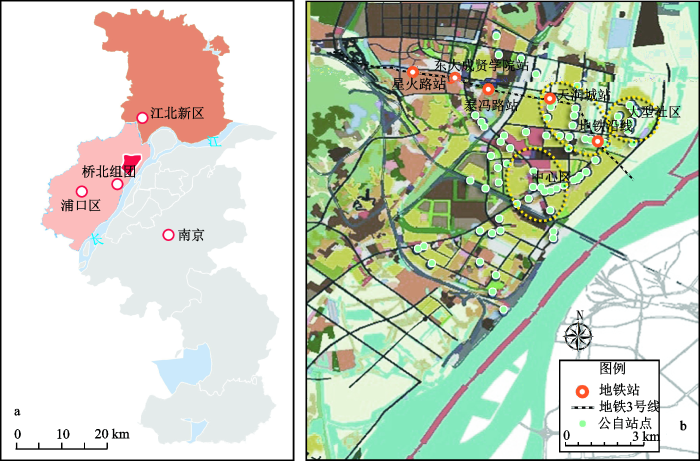
南京是国内发展公自较早的城市之一,桥北片区位于南京市浦口区长江大桥北部,是正在建设的国家级新区“南京江北新区”的核心建设区域。片区建成面积为16.5 km2,现状用地以商业、居住、工业为主,目前片区承担着国家江北新区主要的商住职能,已开通地铁3号及S8号线,同时已形成较为完善的对内外公共交通网络,规划该片区定位为以居住和服务功能为主,将建设成为设施配套完善、居住环境优良的现代滨江宜居生活区。早在2014年片区就已开始建设公自系统,自2015年第二季度正式运营以来,用户量逐步增多,目前已有近3万名持卡用户,选择公自出行已成为片区内居民短途出行的主要方式,片区内已布设有72个公自站点,3 205个车桩,运营车辆达到3 500辆(图1)。
图1 南京桥北片区(a)、桥北片区公共自行车站点(b)
Fig.1 Location of Qiaobei area (a) and the distribution of bike station in Qiaobei area (b) of Nanjing City
本研究涉及的数据包括公自运营数据和建成环境数据两部分。运营数据由南京市浦口公共自行车运营管理公司提供,采集了2015年4~9月桥北片区所有正常使用的公自IC卡数据,数据中记录了使用者每一次公自出行的完整记录,具体包括使用者IC卡的卡号、借还站点的代码,借还时间,骑行的时长,自行车状态,所使用公自的唯一编号(表1),得到216 205条记录数据,剔除使用时间小于2 min及人工调度及异常使用的记录后,本文最终选取了有效的记录数据192 681条。随着基于位置服务业(LBS)的不断发展,已有越来越多的地图服务商(百度地图、腾讯地图、Google map 等)逐步开放了丰富的地图服务应用接口,这一方面降低了地图数据获取的成本,同时也实现了基于用户的地图信息扩展与丰富。POI可理解为信息点(point of information)或兴趣点(point of interesting),是一种代表真实地理实体的点状数据,其主要包含地理坐标(经纬度)名称、类别、地址等信息,此类网络开放数据可作为研究建成环境的主要数据源[21,22,23]。本研究中片区建成环境数据的获取采用百度地图(http://lbsyun.baidu.com/)提供的PlaceAPI以及静态图API开放接口,基于python编写网页端的调用程序,一方面采集了覆盖研究区全域的公里网格所有单元格内17大类地理实体的名称,地理坐标、所属亚类、地址等属性信息数据,同时依照不同地理实体承担的功能及提供的服务,结合本研究的需求对原始POI数据开展重分类,采用其中4个大类(购物休闲、居住、交通、餐饮);另一方面,获取不同尺度的研究区静态地图,基于ArcGIS开展对地图道路交通数据的矢量化工作,从而获取研究区道路交通矢量数据,在此基础上采用GIS网络分析法分别获取不同站点距最近地铁站的距离等建成环境因子。
表 1 公共自行车刷卡数据样例
Table 1 The sample of public bike usage data
| 卡号 | 自行车状态 | 借出站点代码 | 借出时间 | 还入站点代码 | 还入时间 | 骑行时长 | 公自编号 |
|---|---|---|---|---|---|---|---|
| (年/月/日 时:分) | (年/月/日 时:分) | (s) | |||||
| 2078 | 201 | 1040 | 2015/5/23 10:16 | 1001 | 2015/5/23 10:30 | 789 | 141507 |
| 6477 | 201 | 1002 | 2015/4/3 7:12 | 1001 | 2015/4/3 7:18 | 371 | 141174 |
| 37475 | 201 | 1001 | 2015/9/10 7:51 | 1001 | 2015/9/10 8:00 | 547 | 153345 |
| 20686 | 201 | 1002 | 2015/5/26 7:48 | 1001 | 2015/5/26 7:54 | 358 | 80251077 |
| 6477 | 201 | 1040 | 2015/9/10 6:42 | 1001 | 2015/9/10 6:53 | 654 | 140825 |
| 9748 | 201 | 1015 | 2015/7/27 9:12 | 1001 | 2015/7/27 9:19 | 382 | 140977 |
| 3405 | 201 | 1001 | 2015/5/13 16:56 | 1001 | 2015/5/13 17:21 | 1486 | 141730 |
| 15950 | 201 | 1040 | 2015/8/17 8:04 | 1001 | 2015/8/17 8:15 | 650 | 141484 |
论文采用GIS的空间分析方法探索公自使用的空间分布特征,同时结合网络分析方法构建公自站点尺度的建成环境因子集,利用多元回归分析的方法探索公自使用与建成环境间的关系。
采用描述统计的方法分析计算片区内公自使用平均时长分布,使用时间分布特征,以及各站点单位时间内的公自使用总量、租借量、归还量等特征指标,进而采用核密度估计法分析站点及其使用指标的空间分布特征。参考国内外相关研究文献,采用GIS缓冲区分析,确立站点缓冲区的范围为300 m[24,25,26],提取站点缓冲区范围内的建成环境因子,并通过GIS网络分析方法提取公自站点至最近地铁站点间的距离,综合上述分析结果构建公自站点建成环境因子集。最后,根据公自使用时间特征,划分为不同的使用时段,分别获取不同时段内站点每小时使用量(借租量、归还量),以不同时段内小时使用量为因变量,以站点周围的各类建成环境因子为自变量,采用多元回归方法分析不同的建成环境因子与公自使用间的关系,并探讨同一因子在不同时段内对公自使用不同环节的影响变化。多元回归公式如下:
式中,
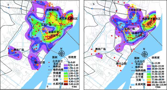
在空间分布上,站点主要分布于片区中心主干道大桥北路两侧,东侧集中分布在位于片区中心区域的江山路沿线、天润城和威尼斯等大型社区附近,以及南北走向的柳州东路沿线,西侧则零星分布在主干道柳州北路沿线、体育公园及澳林广场,片区站点的分布呈现出东侧集聚、西侧分散的现象。采用核密度分析方法分析片区站点的分布,结果显示(图2a)公自站点在空间上分布极不均衡,呈现出以区域商业中心区及大型住宅区为中心集聚,并逐步向边缘分散的特征。具体来讲,在片区内形成了较为明显的3个站点高密度集聚区,分别是片区东北角的大型社区(天润城、威尼斯水城)分布区、地铁3号线柳州东路站至天润城站沿线区域、以及片区中心大型商业购物中心集聚区。
图2 公共行车站点分布(a)、站点使用核密度(b)
Fig.2 The distribution of bike station(a) and the kernel density of the station usage(b)
根据用户刷卡数据,片区公自日均使用次数为1 107.36次,使用平均时长为12.81 min,公自的使用在时段上,也呈现出了明显的早晚高峰现象(图3),早晚高峰时段的骑行时长也存在明显差异,早高峰平均使用时长为10.32 min,晚高峰为14.11 min,这种差异的存在,可能是由于在早高峰通勤时段,居民选择公自的出行行为多为单目标、单任务,如前往公共交通换乘点、工作地等区域,而在晚高峰通勤时段,居民选择公自的出行行为倾向于多目标、多任务,如使用者可能会在骑行途中安排其他事宜,如购物、收发快递、骑行锻炼等,因此在骑行时长上较早高峰长。
为更好的揭示公自使用的时空特征,以站点单位小时内的借、还量作为使用指标,采用核密度分析方法,分析片区公自使用的空间特征,结果表明(图2b),片区公自使用在空间分布上呈现出明显的集聚特征,高使用量的站点主要集中在大桥北路以东的区域,且呈现出单核心圈层空间形态,高频使用的核心出现在地铁三号线柳州东路站至大型社区威尼斯的沿线区域,其次为片区中心大型购物中心集聚区域。这与站点多中心的空间分布存在明显的差异(图2)。
以片区公自使用的时间分布特征及所对应的时段为依据,同时结合该区域内其他公共交通的运营时段,将公自使用时段划分为早晚高峰及其他时段(早高峰为6~9时、晚高峰16~19时,其他时段为1~5、10~15以及20~0时),分别计算不同时段内每个站点的公自小时借还量,结合站点空间分布,采用核密度分析方法综合分析不同时段内的公自使用时空间差异特征。
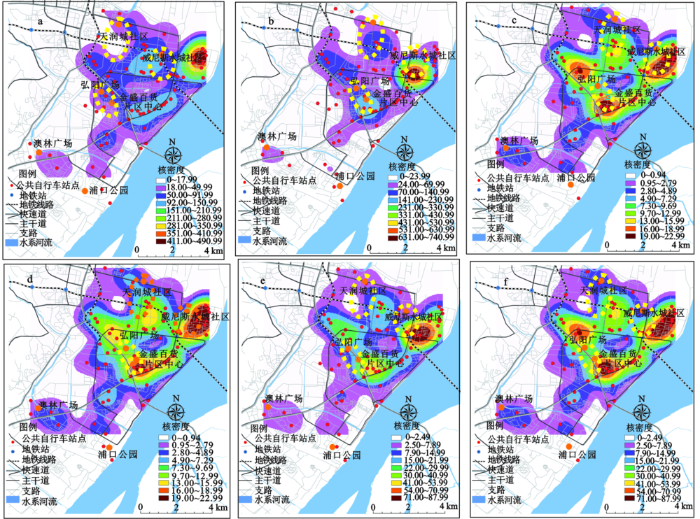
分析结果(图4)显示:在早高峰阶段,公自高使用量站点主要围绕在社区和邻近地铁站沿线,且呈现出社区附近的站点以借出为主,而以地铁站为中心的沿线邻近站点及片区中心的商务区站点以还入为主的使用特征。在晚高峰时段,地铁站及社区附近站点仍然是公自高使用量的集聚区域,但在空间分布上较早高峰分散,公自借出量最高的站点分布为邻近地铁站点的区域,其次是大桥北路沿线的片区中心商务区,高还入量站点集聚区则为以威尼斯社区为中心的片区东北部高密度住宅分布区,以及南北走向的江山路沿线住宅分布区;在其他时段,片区公自的高频使用空间分布,相比早晚高峰时段则更为分散,主要集聚在威尼斯社区、地铁站、片区主干道红山路沿线及大桥北路沿线的中心商务区,从而在空间上形成了“L”型的高频使用站点集聚区,公自高借出量的站点集聚区分别为临近地铁站及住宅区、以及片区中心商务区,而高还入量的站点集聚区则为片区内部主干道红山路及邻近地铁站点沿线区域。在空间上高频使用的公自站点,主要集中于高密度住宅区、中心商务区及邻近地铁站点的沿线区域。
图4 不同时段公共自行车借还时空分布特征
a、c、e为早高峰、其他时段、晚高峰借出;b、d、f为早高峰、其他时段、晚高峰还入
Fig.4 The spatio-temporal characteristics of bike arrival and departure in different time period
由上述的特征分析可知,片区公自使用存在明显的早晚潮汐现象,且不同时段公自使用的时空间差异显著,在空间上公自高使用量区域主要集聚在大型住宅社区分布区、中心商务区及邻近地铁站点的沿线区域,这与站点布置集聚区在空间上存在明显差异。公自使用的时空差异的形成与公自站点周围的建成环境存在紧密的关系[26],参考国内外相关文献,结合刷卡数据的属性,本研究主要采用多元回归方法,分析站点周围不同建成环境影响因子与公自站点使用量间的关系,并探讨不同时段间的影响差异。
随着LBS服务使用的普及,网络开放地图中的POI数据内容也日趋丰富,已有越来越多的城市出行行为研究中将POI数据作为表征建成环境的一项重要的数据源。但因POI数据中地物忽略了实体对象的建筑面积或占地面积,统一抽象成无面积、无体积的点[27],而本研究区内居住类站点多处于超大型社区内①(①参考百度百科显示天润城社区总建面积为2.84 km2,威尼斯社区总建筑面积为3 km),因此采用原始POI数据中的住宅区个数表征建成环境中的住宅类因子来测度对站点的影响不符合研究区的建成现状。在参照出行与建成环境研究中的建成环境测度规则[28,29]的基础上,同时结合研究区内数据的可获取性,本研究最终将建成环境因子分为,站点基础设施、公共交通、日常服务设施三大类因子(表2)。
表 2 建成环境因子选取
Table 2 Descriptive of sample characteristics
| 建成环境类别 | 建成环境因子 | 描述(内容) | 均值 | 标准差 |
|---|---|---|---|---|
| 站点基础设施 | 站点容量 | 站点桩位数量 | 44.81 | 9.27 |
| 支路里程(m) | 站点300 m缓冲区范围内支路总里程 | 200.19 | 102.5 | |
| 次干道里程(m) | 站点300 m缓冲区范围内次干道总里程 | 36.23 | 33.15 | |
| 主干道里程(m) | 站点300 m缓冲区范围内主干道总里程 | 14.47 | 41.5 | |
| 公共交通 | 公自站点 | 站点300 m缓冲区范围内的其他公自站点数量 | 0.72 | 0.9 |
| 公交站点 | 站点300 m缓冲区范围内的公交站点数量 | 0.95 | 1.35 | |
| 距地铁站的距离(m) | 站点距最近站点的距离 | 2016.69 | 1335.25 | |
| 日常服务设施 | 购物网点 | 站点300 m缓冲区范围内的超市、便利店等购物网点数量 | 2.2 | 2.33 |
| 餐饮网点 | 站点300 m缓冲区范围内的餐饮网点数量 | 8.4 | 10.23 | |
| 公园绿地广场 | 站点300 m缓冲区范围内的公园绿地广场数量 | 0.01 | 0.13 |
站点基础设施因子为站点的容量,以及站点一定范围内主、次、支路的里程;公共交通因子的选取,主要考虑了使用者出行过程中多种出行方式间衔接的便捷性、丰富性和站点的通达性,在本次研究中分别选取了围绕公自站点一定范围内的其他公自站点、公交车站点数量以及距最近地铁站点的距离;日常服务类的因子的选取,主要为日常生活中购物、餐饮以及休闲娱乐等活动开展的场所,居民对此类日常服务点的选择,主要以居住地、工作地为出发地,且选择出行成本较少的服务点完成,因此,站点周围此类因子的聚集与否,将在一定程度上影响居民对公自站点的选择及使用。
研究采用多元回归方法,分别分析不同的建成环境因子对3个时段,早高峰、晚高峰及其他时段内的每小时公自借出量、还入量的影响。模型结果显示:站点周围建成环境对公自的使用存在一定的影响,不同时段内影响公自使用的影响因素存在一定的差异,同一因子对公自使用中不同环节的影响也存在差异性,且在不同时段上影响的程度也不相同(表3)。
表 3 模型结果
Table 3 Results of model estimation
| 使用量 | 早高峰时段 | 晚高峰时段 | 其他时段 | |||||||||||
|---|---|---|---|---|---|---|---|---|---|---|---|---|---|---|
| 借出 | 还入 | 借出 | 还入 | 借出 | 还入 | |||||||||
| 系数 | t值 | 系数 | t值 | 系数 | t值 | 系数 | t值 | 系数 | t值 | 系数 | t值 | |||
| (常量) | 3.4963 | 12.1520*** | 0.1986 | 0.3350 | -0.3320 | -0.7390 | 1.3159 | 2.6720* | -0.0658 | -0.1980 | 0.4268 | 1.3480 | ||
| 餐饮网点 | - | - | 0.0253 | 2.7890** | - | - | - | - | - | - | - | - | ||
| 购物网点 | - | - | - | - | - | - | - | - | 0.0495 | 2.4550* | 0.0359 | 2.1120* | ||
| 距地铁站的距离 | -0.1864 | -2.3480* | -0.1535 | -2.1210* | -0.1616 | -2.6230* | -0.1595 | -2.1590* | -0.1257 | -2.8090** | -0.1170 | -2.8210** | ||
| 公交站点 | -1.6125 | -2.5781* | - | - | - | - | - | - | - | - | - | - | ||
| 公自站点 | -0.2857 | -2.7290** | - | - | - | - | -0.3024 | -3.5580*** | -0.1653 | -2.0670* | -0.2075 | -3.7900*** | ||
| 次干道里程 | - | - | 0.0097 | 3.6390*** | 0.0066 | 3.1420** | - | - | - | - | - | - | ||
| 站点容量 | - | - | 0.0549 | 4.7670*** | 0.0385 | 4.4160*** | - | - | 0.0251 | 3.8860*** | 0.0209 | 3.7630*** | ||
| R2 | 0.5314 | 0.5436 | 0.5192 | 0.743 | 0.5343 | 0.5298 | ||||||||
站点300 m范围内的餐饮网点、购物网点、公交站点、其他公自站点,次干道的里程,距最近的地铁站点的距离以及站点的容量(桩位数)是影响公自使用的主要建成环境因子,其中餐饮网点、购物网点的密度,次干道的里程及站点的容量与站点公自借出、还入都存在的正向相关,而站点距最近的地铁站的距离、以及站点缓冲区范围内的其他公自站点及公交站点的数量则与公自的使用存在负相关。
购物网点的密度在非通勤时段内与公自借出及还入存在较为显著的正相关,这表明此时段内站点周围的购物网点的数量会促进公自的使用,即站点周围购物网点聚集的越多,此类站点公自的使用也越多。公自站点与最近地铁站点的距离与所有时段内的公自借出,归还皆存在负相关,且相关性显著,即公自站点距地铁站越远,则站点公自使用量越少,换而言之,公自站点距地铁站越近,则站点公自使用量越高,这与上述公自使用空间分析中的早晚高峰时段公自使用空间分布特征相一致,进一步说明公自与地铁站间的短途通勤接驳是片区内尤为重要的公自使用模式。站点缓冲区范围内的次干道里程与公自的使用存在正相关;站点附近的公交站点数量则与公自使用间存在负相关,这与文献[30]研究结果一致,而与学者朱玮、刘冰等[4]研究结果存在一定的差异,这一方面是由于在一些较小的城市或大城市中相对独立的片区内,在短途出行选择中,相比公交出行公自在出行费用成本方面更为低廉(公自使用中前两个小时内免费),另一方面因片区较为独立,且建成区面积小,片区内大部分的短途出行可选择单一的交通出行方式独立完成整个行程,因此在一定程度上减弱了公自与公交站点间的接驳互通出行。同时,这也说明城市在选择开展公自系统建设前要紧密的结合建设区的实际,确立公自在公共交通系统中所承担的主要职能,以及服务的能力。公自站点的密度(300 m缓冲区范围内的其他公自站点)与公自使用的两个环节都存在负相关,而站点自身的容量则与公自使用量间存在正相关,表明公自站点一定范围内的站点间存在一定竞争关系,公自用户在使用中更倾向于选择大容量的站点,以便顺利的借还车辆完成出行。
本研究以公自实际运营的大数据为基础,结合网络开放数据,在分析公自使用时空特征的基础上,结合公自使用的时间分布特征,将公自的使用分为早晚高峰时段及其他时段,通过多元回归的方法分析不同建成环境因子对站点公自使用的影响,同时探讨因子在不同时段上与公自使用间的相关关系及影响程度,本研究得出以下结论:
1) 片区内的公自使用具有明显的早晚高峰现象,且主要集中在早晚通勤时段,从高频使用站点的空间分布来看,片区内的公自使用模式主要为社区、地铁站及商务中心三者相互间的短途接驳,这表明片区的公自使用主要用于早晚高峰时段的短途接驳通勤,同时,公自站点空间布局与使用的空间分布存在较大的差异,这种差异的形成受到了站点周围的建成环境的影响。
2) 临近站点的日常服务设施、公共交通供给以及站点容量等是影响站点公自使用的主要建成环境因子,这些因子对站点公自使用不同环节间的影响存在差异,同时,在不同时间段间对公自使用的影响程度也存差异。
3) 站点邻近的餐饮、购物网点的密度与公自的使用具有显著的正相关关系,这表明站点附近相关的设施越密集,站点公自的使用频率越高;站点距地铁站越近,则公自使用越高,且在使用环节中,早高峰以还入为主,晚高峰则以借出为主,表明公自与地铁间的短途通勤接驳是片区内公自出行的主要模式。在未来的公自站点规划调整中,应适当增加地铁站点周边的布局,从而进一步的提升公自在公共交通换乘、接驳方面的支撑能力,在站点设置中应遵循低密度高容量的配置原则,在保证公自服务辐射范围的基础上,有效的提升每个站点的使用效率。
4) 研究也发现:公自站点与临近的公交站点在存在一定出行竞争关系,这与部分已开展的研究结果,以及公自运营管理者的日常认知存在偏差,这可能与城市建成规模大小有关。本研究区相对于南京主城区较为独立且建成区面积较小、建成环境紧凑,因此居民的出行多为短途出行,而公自的低成本和易获取特征使其在短途出行中比公交更易吸引用户。这表明在公自站点规划中要紧密结合建设区内实际现状,如主要的公交出行方式、公交系统的运营现状等,明确公自系统在城市公共交通中所承载的职能,科学地预估公自服务的能力,避免盲目地开展大规模的公自系统建设;一定范围内的公自站点间存在竞争关系,因此要适当的设置公自站点的分布密度;站点的容量越大,则公自使用量越大,这是由于用户在选择公自出行中更倾向于选择大容量的站点,以确保站点具有充足的车辆及桩位用于借还,从而保证能够顺利的完成公自正常的借还。
在大数据的背景下,海量的交通运营数据及丰富的网络开放数据,为以参与者视角的研究城市公共交通问题提供了数据基础。本研究采用将公自运营数据与网络开放数据相结合的研究方法,在公自使用的时空间特征的细粒度分析基础上,探讨不同的时段内的站点公自使用与建成环境的关系,研究结果在揭示公自使用与建成环境间的关系的基础上,能够较好的诠释使用空间差异的成因,研究结果可为城市公自站点的空间布局优化、拟建站点的选址与容量配置以及为解决无桩型共享单车的停放和运营监管问题提供科学的参考依据。
此外,本文侧重于提出公自运营数据与网络开放数据相结合的研究方法,而在建成环境因子构建中因受限于案例地非网络开放数据的可获取性,所以在研究中多采用网络开放地图中的POI数量构建环境因子指标,而未能对与公自使用片区的土地利用类型,自行车车道条件,天气以及相关社会经济属性如人口密度、社区类型等因素做定量分析,未来可在此框架基础上进一步丰富的建成环境因子的多维性,同时结合公自使用主体的行为特征,更加深入地研究公自使用与建成环境关系,从而为更加科学合理的指导城市公自系统的建设与运营提供决策依据。另外,在共享单车停放与运营监督管理缺乏规范性等问题越来突出的背景下,可按照此研究方法框架采用共享单车的使用数据,深入开展车辆使用与建成环境关系的探讨,在解决目前共享单车发展面临的问题的基础上,为解决城市居民出行的需求问题,提供多样化的解决途径和科学的参考依据。
The authors have declared that no competing interests exist.
| [1] |
公共自行车文献综述 [J].Narelle Haworth et al.A review of public bike research . |
| [2] |
Optimizing the location of stations in bike-sharing programs: A GIS approach [J].https://doi.org/10.1016/j.apgeog.2012.07.002 URL [本文引用: 1] 摘要
A growing number of cities are implementing bike-sharing programs to increase bicycle use. One of the key factors for the success of such programs is the location of bike stations in relation to potential demand (population, activities and public transport stations). This study proposes a GIS-based method to calculate the spatial distribution of the potential demand for trips, locate stations using location llocation models, determine station capacity and define the characteristics of the demand for stations. The results obtained are compared with the most commonly used location llocation modeling approaches: minimizing impedance and maximizing coverage. For the objective of this study, the latter approach is more useful. Diminishing returns are observed in both cases: as the number of stations increases, there is less improvement in the fraction of the population covered and accessibility to stations. Because the spatial structure of the proposed network also plays an important role in bike-station use, an additional accessibility analysis was carried out to calculate the volume of activity to which a station has access. With this analysis, stations that are relatively isolated, and therefore of little use to potential users, can be eliminated.
|
| [3] |
公共自行车交通发展模式比较 [J].Mai Xianmin et al. Over review of bicycle transportation development in Urban Areas . |
| [4] |
上海市闵行区公共自行车出行特征研究 [J].
以上海闵行区公共自行车系统为例,考察该系统自实施以来对闵行区居民出行产生的影响,以期为闵行以及我国的公共自行车事业发展提供借鉴。研究以使用者的刷卡数据样本以及实地问卷调查获得的样本为数据基础,首先总结不同区域、不同用地类型的公共自行车网点的运行特征。接着以居民为对象,总结使用公共自行车的出行目的、频率变化、网点使用时空分布、出行方式转换、使用公共自行车的原因以及使用模式。最后分析在虚拟收费和费用返还的情景下,人们使用公共自行车的意愿变化。
Wang De et al. Research on the travel characteristics of Public Bicycle in Minhang district Shanghai .
以上海闵行区公共自行车系统为例,考察该系统自实施以来对闵行区居民出行产生的影响,以期为闵行以及我国的公共自行车事业发展提供借鉴。研究以使用者的刷卡数据样本以及实地问卷调查获得的样本为数据基础,首先总结不同区域、不同用地类型的公共自行车网点的运行特征。接着以居民为对象,总结使用公共自行车的出行目的、频率变化、网点使用时空分布、出行方式转换、使用公共自行车的原因以及使用模式。最后分析在虚拟收费和费用返还的情景下,人们使用公共自行车的意愿变化。
|
| [5] |
广州市自行车交通发展特征及对策分析 [J].Analysis on the characteristics and countermeasures of bicycle traffic in Guangzhou . |
| [6] |
公共自行车系统选址适宜性评价——以北京市地铁1号线为例 [J].
构建了表征公共自行车选址适宜性的土地利用复杂度指数,对北京市轨道交通1号线19个站点周边2公里范围内的土地利用复杂度进行了计算。结果表明:该19个站点的复杂度指数由中心区向外围区逐步降低,可以将其划分为3个区间,区间Ⅱ的适宜性最高,区间1次之,区间Ⅲ最低。通过对比北京市公共自行车系统的实际建设状况,可发现北京市目前的公共自行车系统主要覆盖了适宜性评价结果较高的区域。今后,应考虑在复杂度较高区域的各站点周边,规划设置更多的公共自行车租赁点。而对于复杂度较低的区域可以适当暂缓设置公共自行车系统,以免造成公共资源低效利用的问题。
Li Qiang et al.Suitability evaluation of site selection for public bicycle: A case study of Beijing metro line one .
构建了表征公共自行车选址适宜性的土地利用复杂度指数,对北京市轨道交通1号线19个站点周边2公里范围内的土地利用复杂度进行了计算。结果表明:该19个站点的复杂度指数由中心区向外围区逐步降低,可以将其划分为3个区间,区间Ⅱ的适宜性最高,区间1次之,区间Ⅲ最低。通过对比北京市公共自行车系统的实际建设状况,可发现北京市目前的公共自行车系统主要覆盖了适宜性评价结果较高的区域。今后,应考虑在复杂度较高区域的各站点周边,规划设置更多的公共自行车租赁点。而对于复杂度较低的区域可以适当暂缓设置公共自行车系统,以免造成公共资源低效利用的问题。
|
| [7] |
城市居民使用市内公共自行车的满意度影响因素分析——以苏州市为例 [J].Analysis of the influencing factors of urban resident to use urban public bikes: A case study of Suzhou . |
| [8] |
城市公共自行车系统发展研究 [D].Research on the development of urban public bicycle system . |
| [9] |
公共自行车出行质量实证研究 [J].https://doi.org/10.3969/j.issn.0253-374x.2014.07.014 URL [本文引用: 1] 摘要
以上海闵行区公共自行车系统为例,调查获得人们在公共自行车系统实施之后出行方式的转换,采用离散选择模型解释这种转换下的决策机制.发现公共自行车特征、出行时耗以及服务点可达性是出行方式转换的重要影响要素.应用模型发现公共自行车使用者的出行质量显著提升,而出行总质量提升最多的集中于较为功利性的出行目的.转换自公交方式的出行获得质量提升最多,转换自小汽车的出行质量提升最少.预估并比较服务站点密度增加和公共电动自行车两种服务方式的竞争力发现,后者对出行质量提升的效果明显高于前者.
Travel Quality by Public Bicycles: An empirical study .https://doi.org/10.3969/j.issn.0253-374x.2014.07.014 URL [本文引用: 1] 摘要
以上海闵行区公共自行车系统为例,调查获得人们在公共自行车系统实施之后出行方式的转换,采用离散选择模型解释这种转换下的决策机制.发现公共自行车特征、出行时耗以及服务点可达性是出行方式转换的重要影响要素.应用模型发现公共自行车使用者的出行质量显著提升,而出行总质量提升最多的集中于较为功利性的出行目的.转换自公交方式的出行获得质量提升最多,转换自小汽车的出行质量提升最少.预估并比较服务站点密度增加和公共电动自行车两种服务方式的竞争力发现,后者对出行质量提升的效果明显高于前者.
|
| [10] |
Ng W Y et al. A review on the effects of physical built environment attributes on enhancing walking and cycling activity levels within residential neighborhoods [J].https://doi.org/10.1016/j.cities.2015.08.004 URL [本文引用: 1] 摘要
The growing worldwide awareness of the significant impacts of physical activities on physical and physiological health has aroused great interest in the role of the physical built environment plays in walking and cycling activities. This comprehensive review shows how specific details of the built environment enhance people's walking and cycling. This was accomplished through identifying the barriers to walking and cycling activities as well as the general and specific characteristics of the major physical built environment attributes within a residential neighborhood that can help overcome these barriers and enhance the walking and cycling activity levels. Also the effectiveness of some individual attributes was also compared. Of particular value of this study is that its structure and level of details of information laid out in this review can facilitate building designers and neighborhood planners in creating a supportive environment within residential neighborhoods.
|
| [11] |
Station-Level forecasting of bikesharing ridership: Station network effects in Three US Systems [J].https://doi.org/10.3141/2387-06 URL [本文引用: 1] 摘要
This study investigated the effects on bikesharing ridership levels of demographic and built environment characteristics near bikesharing stations in three operational U.S. systems. Although earlier studies focused on the analysis of a single system, the increasing availability of station-level ridership data has created the opportunity to compare experiences across systems. In this study, particular attention was paid to data quality and consistency issues raised by a multicity analysis. This project also expanded on earlier studies with the inclusion of the network effects of the size and spatial distribution of the bikesharing station network, which contributed to a more robust regression model for the prediction of station ridership. The regression analysis identified a number of variables that had statistically significant correlations with station-level bikesharing ridership: population density; retail job density; bike, walk, and transit commuters; median income; education; presence of bikeways; nonwhite population (negative association); days of precipitation (negative association); and proximity to a network of other bikesharing stations. Proximity to a greater number of other bikesharing stations exhibited a strong positive correlation with ridership in a variety of model specifications. This finding suggested that, with the other demographic and built environment variables controlled for, access to a comprehensive network of stations was a critical factor to support ridership. Compared with earlier models, this model is more widely applicable to a diverse range of communities and can help those interested in the adoption of bikesharing systems to predict potential levels of ridership and to identify station locations that serve the greatest number of riders.
|
| [12] |
El-Geneidy A M et al. How land-use and urban form impact bicycle flows: Evidence from the bicycle-sharing system (BIXI) in Montreal [J].https://doi.org/10.1016/j.jtrangeo.2014.01.013 URL [本文引用: 1] 摘要
Installed in 2009, BIXI is the first major public bicycle-sharing system in Montreal, Canada. The BIXI system has been a success, accounting for more than one million trips annually. This success has increased the interest in exploring the factors affecting bicycle-sharing flows and usage. Using data compiled as minute-by-minute readings of bicycle availability at all the stations of the BIXI system between April and August 2012, this study contributes to the literature on bicycle-sharing. We examine the influence of meteorological data, temporal characteristics, bicycle infrastructure, land use and built environment attributes on arrival and departure flows at the station level using a multilevel approach to statistical modeling, which could easily be applied to other regions. The findings allow us to identify factors contributing to increased usage of bicycle-sharing in Montreal and to provide recommendations pertaining to station size and location decisions. The developed methodology and findings can be of benefit to city planners and engineers who are designing or modifying bicycle-sharing systems with the goal of maximizing usage and availability.
|
| [13] |
D Arcier B F. Modeling bike sharing system using built environment factors [J].https://doi.org/10.1016/j.procir.2015.02.156 URL [本文引用: 1] 摘要
This paper aims to present a modeling of bike sharing demand at station level in the city of Lyon. Robust linear regression models were used in order to predict the flows of each station. The data used in this project consists of over 6 million bike sharing trips recorded in 2011. The built environment variables used in the model are determined in a buffer zone of 300 meters around each bike sharing station. In order to estimate the bike sharing flow, we use the method of linear regression during the peak periods of a weekday. The results show that bike sharing is principally used for commuting purposes by long term subscribers while short term subscriber's trips purposes are more varied. The combination between bike sharing and train seems to be an important inter-modality. An interesting finding is that student is an important user of bike sharing. We found that there were different types of bikesharing usage which are influenced by socio-economic factors depending on the period within the day and type of subscribers. The present findings could be useful for others cities which want to adopt a bikesharing system and also for a better planning and operation of existing systems. Further, the solutions to encourage the use of bikesharing will be various depending on type of subscribers. The approach in this paper can be useful for estimating car-sharing demand.
|
| [14] |
信息时代的地理学与人文地理学创新 [J].
<p>在分析信息技术与地理学相关研究的基础上,重点讨论了中国人文地理学的发展与创新问题,包括基于大数据应用的方法革新、流动空间分析的框架、人地关系理论体系与应用研究等内容。未来中国人文地理学的发展,一方面要打破传统的学科框架,积极吸纳相关学科理论、方法和技术方面的创新成果,构建信息时代人文地理学理论与方法体系;另一方面,要立足中国国情与特色,紧扣国家战略,增强人文地理解决问题的能力,加强面向问题的综合应用研究。</p>
The iInnovation of geography and human geography in the information era .
<p>在分析信息技术与地理学相关研究的基础上,重点讨论了中国人文地理学的发展与创新问题,包括基于大数据应用的方法革新、流动空间分析的框架、人地关系理论体系与应用研究等内容。未来中国人文地理学的发展,一方面要打破传统的学科框架,积极吸纳相关学科理论、方法和技术方面的创新成果,构建信息时代人文地理学理论与方法体系;另一方面,要立足中国国情与特色,紧扣国家战略,增强人文地理解决问题的能力,加强面向问题的综合应用研究。</p>
|
| [15] |
“大数据”热潮下人文地理学研究的再思考 [J].Rethink human geography in the age of big data . |
| [16] |
基于交通网络中心性的长春市大型综合医院空间可达性研究 [J].
交通网络中心性是测度交通网络及社会经济活动可达性的有效手段。从交通网络中心性视角,结合可达时间研究长春市中心城区大型综合医院空间可达性。大型综合医院邻近度和中间性与距离(到人民广场路网距离)均呈负相关,在距人民广场最近处二者大致相等且最高,随着距离的增加,邻近度超过中间性。距人民广场4740—5799米处中间性超过邻近度并形成高值分布区,7862—8400米处二者均降到最低。约33.3%的大型综合医院空间可达性最好,其集中分布于以人民广场为中心的城市中心。空间可达性最差的大型综合医院约占总数的24.1%,多分布于城市边缘。空间可达性较差的大型综合医院为数不多,且多分布于城市周边。但高邻近度、高中间性、可达时间较长的大型综合医院主要分布于安达街沿线。高邻近度、低中间性,可达时间较短的大型综合医院则多分布于火车站前与新民大街沿线等城市中心位置。
Spatial accessibility of large general hospitals in changchun city center based on street network centrality .
交通网络中心性是测度交通网络及社会经济活动可达性的有效手段。从交通网络中心性视角,结合可达时间研究长春市中心城区大型综合医院空间可达性。大型综合医院邻近度和中间性与距离(到人民广场路网距离)均呈负相关,在距人民广场最近处二者大致相等且最高,随着距离的增加,邻近度超过中间性。距人民广场4740—5799米处中间性超过邻近度并形成高值分布区,7862—8400米处二者均降到最低。约33.3%的大型综合医院空间可达性最好,其集中分布于以人民广场为中心的城市中心。空间可达性最差的大型综合医院约占总数的24.1%,多分布于城市边缘。空间可达性较差的大型综合医院为数不多,且多分布于城市周边。但高邻近度、高中间性、可达时间较长的大型综合医院主要分布于安达街沿线。高邻近度、低中间性,可达时间较短的大型综合医院则多分布于火车站前与新民大街沿线等城市中心位置。
|
| [17] |
大数据与小数据结合: 信息时代城市研究方法探讨 [J].Combination between big data and small data: New methods of urban studies in the information era . |
| [18] |
城市公共自行车使用活动的时空间特征研究——以杭州为例 [J].https://doi.org/10.16361/j.upf.201603009 URL [本文引用: 1] 摘要
为考察公共自行车使用活动的时空间特征,首先提出了基于租赁点的若干使用特征指标,界定了时长势力商、租还潮汐比、桩位周转率等指标的概念及其计算方法.进一步利用杭州某一典型工作日的刷卡数据,通过数据挖掘技术,细粒度、全景式地测度了所有租赁点的使用特征,并对城市各类地域的使用状况进行了比较.研究发现,受空间布局和建成环境的影响,租赁点特征指标值存在明显的个体差异,总体上形成了“圈层式”的空间分异结构,即使用量大、潮汐性弱且周转率高的租赁点集中于中心区,而使用量小、潮汐性强和周转率低的租赁点多分布于主城区边缘和外围组团;非景区租赁点的使用时长普遍小于景区,但短时长使用比例并不高,表明公共自行车接驳作用有限.最后,针对租赁点使用冷热不均、绩效水平差异大、接驳功能弱等问题提出了相关建议.
Zhou Yujie et al.A study on the temporal-spatial features of Bicycle-sharing activities: A case of Hangzho .https://doi.org/10.16361/j.upf.201603009 URL [本文引用: 1] 摘要
为考察公共自行车使用活动的时空间特征,首先提出了基于租赁点的若干使用特征指标,界定了时长势力商、租还潮汐比、桩位周转率等指标的概念及其计算方法.进一步利用杭州某一典型工作日的刷卡数据,通过数据挖掘技术,细粒度、全景式地测度了所有租赁点的使用特征,并对城市各类地域的使用状况进行了比较.研究发现,受空间布局和建成环境的影响,租赁点特征指标值存在明显的个体差异,总体上形成了“圈层式”的空间分异结构,即使用量大、潮汐性弱且周转率高的租赁点集中于中心区,而使用量小、潮汐性强和周转率低的租赁点多分布于主城区边缘和外围组团;非景区租赁点的使用时长普遍小于景区,但短时长使用比例并不高,表明公共自行车接驳作用有限.最后,针对租赁点使用冷热不均、绩效水平差异大、接驳功能弱等问题提出了相关建议.
|
| [19] |
城市公共自行车选择行为研究 [D].Study on the dhoice behavior of urban public bike . |
| [20] |
城市常规公交空间演化过程研究——以广州市为例 [J].Spatial evolution features of transit bus: An empirical study of Guangzhou . |
| [21] |
基于POI数据的广州零售商业中心热点识别与业态集聚特征分析 [J].https://doi.org/10.11821/dlyj201604009 URL [本文引用: 1] 摘要
商业中心是城市零售活动的重要载体,优化商业资源在城市内部空间的合理配置,摸清不同零售经营形态的区位选择,显得尤为重要。以面向公众服务的商业机构兴趣点(POI)数据为研究对象,提出一种城市商业中心与零售业态集聚区识别的方法;以广州市为例,分析商业活动的热点地区以及零售业态集聚区的空间分布特征。研究表明:1根据核密度估计法提取的商业中心在等级上表现出由城市中心圈层向外围圈层扩散的趋势,结果符合客观事实。2以街区为单元,商业网点密度符合局域Getis-Ord G*指数统计特征的热点区域主要分布在越秀区和天河区,广州市零售业发展的双核心空间格局已经形成。3不同的零售业态对商业集聚的区位选择具有显著差异性,百货商店、超市、便利店等零售经营形态的空间集聚特征与该业态的市场定位、经营模式及选址策略基本吻合。总体来看,基于POI数据的广州零售业集聚空间分析结果能够反映实体零售企业行为与广州商业经济分布的相关性,有助于提高政府部门商业规划和零售商选址前期研究的客观性和科学性。
Retail center recognition and spatial aggregating feature analysis of retail formats in Guangzhou based on POI data .https://doi.org/10.11821/dlyj201604009 URL [本文引用: 1] 摘要
商业中心是城市零售活动的重要载体,优化商业资源在城市内部空间的合理配置,摸清不同零售经营形态的区位选择,显得尤为重要。以面向公众服务的商业机构兴趣点(POI)数据为研究对象,提出一种城市商业中心与零售业态集聚区识别的方法;以广州市为例,分析商业活动的热点地区以及零售业态集聚区的空间分布特征。研究表明:1根据核密度估计法提取的商业中心在等级上表现出由城市中心圈层向外围圈层扩散的趋势,结果符合客观事实。2以街区为单元,商业网点密度符合局域Getis-Ord G*指数统计特征的热点区域主要分布在越秀区和天河区,广州市零售业发展的双核心空间格局已经形成。3不同的零售业态对商业集聚的区位选择具有显著差异性,百货商店、超市、便利店等零售经营形态的空间集聚特征与该业态的市场定位、经营模式及选址策略基本吻合。总体来看,基于POI数据的广州零售业集聚空间分析结果能够反映实体零售企业行为与广州商业经济分布的相关性,有助于提高政府部门商业规划和零售商选址前期研究的客观性和科学性。
|
| [22] |
基于日常购物行为的广州社区居住-商业空间匹配关系 [J].The matching pattern of housing-shopping space based on residents’ daily shopping behaviors: A case study of communities in Guangzhou,China . |
| [23] |
竞争型公共设施区位决策——概念,选址原则及模型构建 [J].Competitive public facilities location decision: Concept, location selection principle and model construction [J]. |
| [24] |
Land use effects on bicycle ridership: A framework for state planning agencies [J].https://doi.org/10.1016/j.jtrangeo.2014.10.004 URL [本文引用: 1] 摘要
State and local agencies increasingly recognize the importance of bicycling activity and as the number of riders has grown over the past several years, the agencies are becoming more aware of the need to provide better bicycle infrastructure. This paper proposes a series of empirical models and applies them to the State of Maryland in the United States, using a spatial lag approach to explore land use, built environment, demographic, socio-economic, and traffic condition connections to bicycle ridership, defined as the number of bicycle trips generated by a given analysis zone per day. A set of models is proposed for three land-use typologies: urban, sub-urban and rural. The data that drives this analysis was obtained from a recently conducted Household Travel Survey (HTS) in the Baltimore ashington region in Maryland. Results show that some land uses, socio-economic and demographic characteristics, and transit accessibility are positively correlated with bicycle ridership. Other types of land use, transport system characteristics and income level have an inverse relationship with bicycle ridership. The contributing factors to bicycle ridership vary with land-use typology. This proposed approach could be used to evaluate factors relevant to bicycle demand. State and local agencies are advised to build designated bicycle paths according to traffic conditions and increase bicycle-parking capacity in specific establishments.
|
| [25] |
How accessible and convenient are the public bicycle sharing programs in China? Experiences from Suzhou city [J].https://doi.org/10.1016/j.habitatint.2015.11.007 URL [本文引用: 1] 摘要
61Public bicycle sharing program (PBSP) is becoming popular in Chinese cities.61However, there is still low participation of women, migrant workers and poor families.61Reduce PBSP registration fee.61Engage low income families and migrant workers in PBSP policy discussion.61Enforce traffic rules to create a safe environment for bicycle use.
|
| [26] |
Brussel M et al. Exploring the impact of built environment factors on the use of public bikes at bike stations: Case study in Zhongshan, China [J].https://doi.org/10.1016/j.jtrangeo.2016.11.014 URL [本文引用: 2] 摘要
Many countries have implemented public bike systems to promote sustainable public transportation. Despite the rapid development of such systems, few studies have investigated how built environment factors affect the use of public bikes at station level using trip data, taking account of the spatial correlation between nearby stations. Built environment factors are strongly associated with travel demand and play an important role in the success of public bike systems. Using trip data from Zhongshan's public bike system, this paper employed a multiple linear regression model to examine the influence of built environment variables on trip demand as well as on the ratio of demand to supply (D/S) at bike stations. It also considered the spatial correlations of PBS usage between nearby stations, using the spatial weighted matrix. These built environment variables mainly refer to station attributes and accessibility, cycling infrastructure, public transport facilities, and land use characteristics. Generally, we found that both trip demand and the ratio of demand to supply at bike stations were positively influenced by population density, length of bike lanes and branch roads, and diverse land-use types near the station, and were negatively influenced by the distance to city center and the number of other nearby stations. However, public transport facilities do not show a significant impact on both demand and D/S at stations, which might be attributed to local modal split. We also found that the PBS usage at stations is positively associated with usage at nearby stations. Model results also suggest that adding a new station (with empty capacity) within a 300 m catchment of a station to share the capacity of the bike station can improve the demand-supply ratio at the station. Referring to both trip demand models and D/S models, regression fits were quite strong with larger R 2 for weekdays than for weekends and holidays, and for morning and evening peak hours than for off-peak hours. These quantitative analyses and findings can be beneficial to urban planners and operators to improve the demand and turnover of public bikes at bike stations, and to expand or build public bike systems in the future.
|
| [27] |
基于城市网络空间的POI分布密度分析及可视化 [J].Analysis and visualization of POI distribution density based on urban network space . |
| [28] |
D Arcier B F. Modeling Bike Sharing System using Built Environment Factors [J].https://doi.org/10.1016/j.procir.2015.02.156 URL [本文引用: 1] 摘要
This paper aims to present a modeling of bike sharing demand at station level in the city of Lyon. Robust linear regression models were used in order to predict the flows of each station. The data used in this project consists of over 6 million bike sharing trips recorded in 2011. The built environment variables used in the model are determined in a buffer zone of 300 meters around each bike sharing station. In order to estimate the bike sharing flow, we use the method of linear regression during the peak periods of a weekday. The results show that bike sharing is principally used for commuting purposes by long term subscribers while short term subscriber's trips purposes are more varied. The combination between bike sharing and train seems to be an important inter-modality. An interesting finding is that student is an important user of bike sharing. We found that there were different types of bikesharing usage which are influenced by socio-economic factors depending on the period within the day and type of subscribers. The present findings could be useful for others cities which want to adopt a bikesharing system and also for a better planning and operation of existing systems. Further, the solutions to encourage the use of bikesharing will be various depending on type of subscribers. The approach in this paper can be useful for estimating car-sharing demand.
|
| [29] |
Travel and the built environment: A synthesis [J].https://doi.org/10.3141/1780-10 URL [本文引用: 1] 摘要
Abstract The potential to moderate travel demand through changes in the built environment is the subject of more than 50 recent empirical studies. The majority of recent studies are summarized. Elasticities of travel demand with respect to density, diversity, design, and regional accessibility are then derived from selected studies. These elasticity values may be useful in travel forecasting and sketch planning and have already been incorporated into one sketch planning tool, the Environmental Protection Agency's Smart Growth Index model. In weighing the evidence, what can be said, with a degree of certainty, about the effects of built environments on key transportation "outcome" variables: trip frequency, trip length, mode choice, and composite measures of travel demand, vehicle miles traveled (VMT) and vehicle hours traveled (VHT)? Trip frequencies have attracted considerable academic interest of late. They appear to be primarily a function of socioeconomic characteristics of travelers and secondarily a function of the built environment. Trip lengths have received relatively little attention, which may account for the various degrees of importance attributed to the built environment in recent studies. Trip lengths are primarily a function of the built environment and secondarily a function of socioeconomic characteristics. Mode choices have received the most intensive study over the decades. Mode choices depend on both the built environment and socioeconomics (although they probably depend more on the latter). Studies of overall VMT or VHT find the built environment to be much more significant, a product of the differential trip lengths that factor into calculations of VMT and VHT.
|
| [30] |
Duan Z et al.Sustainable bike-sharing systems: characteristics and commonalities across cases in urban China [J]. |

/
| 〈 |
|
〉 |
